#Eruption confirmed in Iceland
Explore tagged Tumblr posts
Visit Tumblr Blog
Explore Tumblr blogs with no restrictions, modern design and the best experience.
Last Seen Tumblr Blogs


Fun Fact
Tumblr was acquired by Yahoo for $1.1B in 2013.
Text
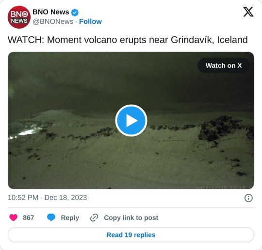
#Eruption confirmed in Iceland#volcanoes#volcanology#eruptions#current events#geology#iceland#Grindavik#fissure eruption
9 notes
·
View notes
Text
youtube
#On the Pulse with Silki
Please Watch, Like, Share Videos, Subscribe
#Magma#Chamber#confirmed#&#New#Risk#Assessment#Iceland#volcano#grindavik#eruption#earthquake#youtube videos#Volcanoes#🌋#Youtube
0 notes
Photo

Christianization of Iceland
The Christianization of Iceland was a smooth transition compared to other Scandinavian countries. While in Norway, Denmark, or Sweden, royal authority played a crucial role in conversion, in Iceland, it was a parliamentary decision, reached by mediation and compromise. Although the Althing proclaimed that everyone should be baptized, private pagan worship and practices were tolerated, reflecting a pragmatic approach to balancing political necessity and community cohesion.
Little Church, Westfjords, Iceland
Barry Marsh (Public Domain)
Political Evolution in Viking Age Iceland
The legendary settlement of Iceland, known as landnám (quite literally the land-taking), took place between approximately 870 and 930 as part of the larger Viking expansion across the North Atlantic. The island was likely discovered around 850, possibly by Scandinavian sailors who had been blown off course. The sources mention a couple of names associated with the island's sighting. First, a sailor from Norway, Naddod, was blown off course while sailing to the Faroe Islands around the mid-9th century, then Gardar Svavarsson from Sweden explored Iceland more systematically. He sailed around the island and confirmed it was a large landmass, settling briefly in Húsavík in the North (nowadays a whale-watching hotspot). Raven-Floki (Flóki Vilgerðarson) attempted a planned settlement in Iceland. He brought livestock but struggled with harsh winters, leading to the death of his cattle. Disheartened, he left, calling the island Ísland (Iceland), the name that eventually endured.
Tradition recognizes Ingólfr Arnarson as Iceland's first permanent settler, a Norwegian chieftain who left Norway allegedly due to conflicts related to King Harald Fairhair's unification efforts. Briefly put, around 874, he sailed to Iceland with his family and household, performed a ritual by throwing his high-seat pillars overboard, and settled where they landed, founding Reykjavík, but only after dealing with murderous slaves as tradition has it.
Ingolfr Arnarson Founding Reykjavik
Haukurth (Public Domain)
Shortly afterwards, news spread throughout Norse communities of vast, uninhabited land with rich pastures and ample fishing grounds. This sparked a wave of migration, primarily from Norway but also from Norse settlements in the British Isles, including Ireland, Scotland, and the Hebrides. Most early settlers were free farmers seeking new opportunities, though some were also minor chieftains. Many Norse settlers who arrived from the British Isles brought Gaelic wives, followers, and slaves, resulting in a mixed Norse-Gaelic population that left a lasting imprint on Icelandic culture.
The traditional date for Iceland's settlement, around 870, is supported by geological evidence, namely the tephra layer, a volcanic ash deposit from a known eruption at that precise time. Over the following decades, thousands of settlers arrived, and by around 930, most of the arable land had been claimed. This period is generally considered the end of the settlement phase and the beginning of the Icelandic Free State, a period that inspired many of the magnificent Icelandic sagas.
There were several reasons why so many people left their homelands to settle in Iceland. Many of those who came from Norway were fleeing the increasing power of King Harald Fairhair, whose efforts to unify Norway under his rule brought higher taxation and greater control over independent landowners. Others were drawn by the promise of free land and the opportunity to establish themselves without interference from kings or large landowners. Additionally, the wealth acquired through Viking raids in Britain and elsewhere in Europe provided the means for some families to finance the long journey and bring livestock and supplies with them. The settlers quickly adapted to their new environment, relying on livestock farming, hunting, and coastal fishing for survival. The island was heavily forested when they arrived, but large-scale tree-cutting for fuel, construction, and pasture led to rapid deforestation. Overgrazing by sheep and other livestock further contributed to soil erosion, a problem that would persist for centuries.
At first, land was taken freely, but as more people arrived, disputes arose over resources. These conflicts were usually resolved through negotiation and agreements among chieftains, rather than through large-scale warfare. The sagas, perhaps not surprisingly, rather tend to remember the troubles and conflicts. To maintain order in this new society, a decentralized system of governance was developed, unique in comparison to Europe's feudalism.
Local chieftains, known as goðar, played a crucial role in mediating disputes and leading communities. This title points out the bundling of political and religious power into a single function, with the chieftain being responsible for organizing rituals. Rather than forming a monarchy or centralized authority, wealth and power in medieval Iceland was distributed among chieftains and free farmers. Medieval Icelandic government had proto-democratic political structure, which culminated in the founding of the Althing in 930 at the site of Thingvellir near Reykjavik. The Althing served as a general assembly where laws were made, disputes were settled, and alliances were formed, marking the transition from a loosely organized settlement to an established commonwealth. Otherwise, the island was divided into 4 quarters and after a series of reforms, the number of chieftains would reach 48.
Continue reading...
28 notes
·
View notes
Text

First evidence of a volcanic spatter cone on Mars
While working under Erika Rader, an assistant professor in the Department of Earth and Spatial Sciences at University of Idaho, a postdoctoral researcher identified a volcanic vent on Mars as a potential spatter cone and compared it to a spatter cone formed during the 2021 eruption of Fagradalsfjall in Iceland.
Through a detailed morphological investigation and ballistic modeling, Ian T.W. Flynn discovered the Martian volcanic feature strongly resembles spatter cones found on Earth.
“Spatter cones are so common on Earth that it seemed extremely unlikely that they simply didn’t exist on Mars,” Rader said. “Since spatter cones can only form in the right conditions, their presence gives us a benchmark to shoot for when simulating Martian volcanoes.”
Spatter cones are created by hot lumps of flying lava falling to the surface during explosive volcanic eruptions, specifically during sustained periods of lava fountaining. They are found in many places on Earth — including in Idaho, most notably at Craters of the Moon National Monument and Preserve — and have long been suspected to be on Mars as well. However, until now, there wasn’t solid evidence of their existence.
“The similarity between the Mars and Icelandic spatter cones indicates that the eruption dynamics occurring in Iceland, over the last several years, also occurred on Mars,” Flynn said. “This is exciting as it expands the range of volcanic eruption styles possible on Mars.”
This discovery can give us clues about how volcanic eruptions happened on Mars, specifically regarding the gases in the magma and the environmental conditions at the time the eruption occurred. It’s also further confirmation that Icelandic — and Idahoan — volcanoes are erupting now the way volcanoes erupted millions of years ago on Mars.
“We are thrilled about this discovery because it fills a distinct observational gap in Martian volcanology, and it lays the groundwork for future investigations of spatter features on Mars,” Flynn said.
Flynn is now a research assistant professor at University of Pittsburgh, but he still collaborates with Rader.
IMAGE: (a) Nadir displayed HiRISE image (ESP_011413_1790) of the potential Martian spatter cone, located south of Pavonis Mons (1 degrees 5.45' S and 113 degrees 24.71' W). (b) Nadir displayed Pleiades visible image from 27 July 2021 (63 degrees 53.44' N and 22 degrees 16.13' W). (c) and (d) are hillshade DEMs of the Martian (2 vertical exaggeration) and Fagradalsfjall spatter cone (6 September 2022) (1 vertical exaggeration) volcanic vents, respectively. Black outlines in (c) and (d) indicate the exterior extent of the vent, and the black line transects are shown in Fig. 2 . (e) and (f) and zoomed in regions shown in (a), and (g) and (h) are zoomed in regions shown in (b).
3 notes
·
View notes
Note
🍄🤡💾
🍄 Describe your wip/one of your wips in the format of ____ + _____ = _______
“Small Enthusiastic Tracy + Uncle Virgil Getting Carried Away = Glitterpocalypse”
💾 What is your document of your wip/ a wip called? (not the stories actual title but what you’ve saved it as)
Hahaha “Final straight” - hilariously I titled it that when I thought the thing would be at least ten chapters less than it has turned out to be so I’ve been on that “Final Straight” since… um… May…
🤡 How many Wips are you actively working on?
Uhhhh *rubs back of neck* soooo it depends how you define “actively” but assuming we say it means I have at least half a plan for it and a decent chunk written (albeit not chronologically, let’s not kid ourselves here) … hmm lemme figure this out…
(Under the cut for rambling and links)
The big boys (2)
Resurface My Earth & Sky magnum opus (so so close to finishing this beastie now and I am so very proud of it)
Estera - my co-written mad sprawling razorfluff Scott-finds-a-friend-and-they-help-each-other-to-live universe… with parts for possibly two sequel fics which I may never use but I keep adding to them so… active… I’ll call it one WIP tho (at risk of @sofasurf locking me up because I keep trying to leap down plot rabbit holes). This one takes up a significant proportion of my brain in daily life, her back story, how that interweaves with Scott’s and their future story is vastly detailed now but will probably mostly not see the light of day. OC fics are never the best at getting engagement with people so I guess time would be better spent on others, maybe, but I’m inherently hopeless at writing the stuff I think I should be and so… yeah, I just love this story and how the two of them interact and the rest of the Tracys’ eyeview on it all (inc EOS, especially EOS) and I actually reread it a fair amount… your primary target audience is yourself, right?
Currently small but could easily get big:
Unnamed Wingman Ash story - so many notes and bits of prose and IDEAS. Constantly at the top of my “last updated” note files but other than posting some random snippets I haven’t actually worked out how to Start that one yet…
Octopus House - teeny adhd Scott at school
Red - the Alan & Havoc one
Shorter ones that should be easily finished off AND YET…
Play it Out - 3/4 just lacking that final chapter to fix what I broke
Sparkly cockroaches - a one-shot gift fic that I’ve been poking at for over a year 😏 whatever state it is in when I finally post it, it will not have been worth the wait but would be good to finish this at some point. Maybe before the second anniversary of the gift date 🙄
Fathers Day - 3/4 chapters done, 4th on its way slowly. Dad!Scott and the Tinies.
An Eyebrow-razing incident - 3/4 done, just gotta do the deed and raze those brows. Because I am a terrible, terrible human.
FishTanked-Up - 2/? I’ve got a morning-after chunk in draft but I have my doubts about them getting to the gallery. Also they might have accidentally adopted Juan… which could complicate things.
Music is Everything 4/? - my first ever TAG fic and although I haven’t made any progress on the finale in a while, I absolutely intend to finish it because it was my first. I might just have to rewrite half of it before that…
Misc insanity
A Very Silly Christmas Fic - the fic that confirmed I have no control over where a supposedly one-shot goes 🙄 Also ACTUAL ICELANDIC volcano erupted and made my crack Hrómundartinhurmindur fic a bit weird. Maybe I’ll finish it in time for this Christmas…
So… if we just count those and ignore the snippety / bullet points / too many exclamation marks plot bunnies then… twelve? That’s actually not as bad as I thought…
#ask answer#writing#thunderbirds fanfiction#I’m still not over the fact you can’t use yellow text in tumblr anymore#ok so this turned into an excuse to finally track everything down and make sure it’s properly tagged#hence it’s taken a while because me and rabbit holes… yeah…#I’ve made myself a to do list now#maybe that will help?#(it will not help)
4 notes
·
View notes
Text
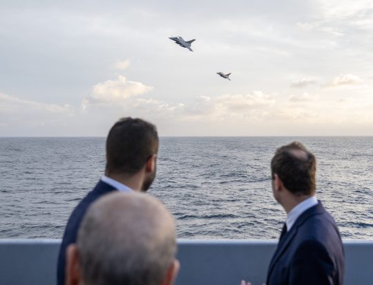
Saudi Defense Minister sees Rafale's demonstration while Riyadh wants 54 aircraft
The kingdom approached Dassault after Germany refused Riyadh's request for Eurofighters.
Fernando Valduga By Fernando Valduga 12/21/2023 - 08:29 in Military
The Saudi Minister of Defense, Prince Khalid bin Salman bin Abdulaziz, today visited the French frigate "Chevalier Paul" in the Mediterranean Sea, in the south of France, where he witnessed an air defense exercise with the participation of a series of Rafale aircraft.
Upon his arrival, His Highness was received by the Minister of the Armed Forces of the French Republic, Sébastien Lecornu, the Saudi Press Agency reported.

Prince Khalid bin Salman bin Abdulaziz received an explanation that included the capabilities of the Rafale jet and the sophisticated and advanced technologies and equipment it contains.
On Wednesday, the Saudi Defense Minister met with French President Emmanuel Macron, where the duo discussed bilateral relations between France and the Saudi Kingdom.
Separately, the CEO of Dassault Aviation, Eric Trappier, confirmed that Saudi Arabia is negotiating the purchase of 54 Rafale aircraft.
Speaking to the Association of Defense Journalists in Paris on December 14, Eric Trappier said that “although Saudi Arabia has traditionally purchased British aircraft, Saudi Arabia's request for 54 Rafales was “independent of the crisis in the Middle East,” he said, indirectly referring to Germany that blocked Saudi Arabia's request for additional Eurofighters due to the kingdom's intervention in the Yemen civil war.
Tags: Military AviationDassault AviationDassault RafaleRSAF - Royal Saudi Air Force/Royal Saudi Air Force
Sharing
tweet
Fernando Valduga
Fernando Valduga
Aviation photographer and pilot since 1992, he has participated in several events and air operations, such as Cruzex, AirVenture, Dayton Airshow and FIDAE. He has works published in specialized aviation magazines in Brazil and abroad. He uses Canon equipment during his photographic work in the world of aviation.
Related news
The Icelandic Coast Guard regularly transports scientists to observe the volcanic eruption near Grindavik. (Photo: Landhelgisgaesla Islands)
HELICOPTERS
VIDEO: Icelandic Coast Guard takes scientists in helicopter to evaluate volcanic eruption
20/12/2023 - 21:00
An F-35A Lightning II poachback returned to Kadena Air Base, Okinawa, on December 18, 2023, without a panel of the aircraft body. (Photo: Satoru Kuba)
INCIDENTS
F-35A fighter loses side panel while flying over Okinawa in Japan
20/12/2023 - 20:26
MILITARY
F-16 fighters will bring better weapons and radar to the Ukrainian Air Force
20/12/2023 - 17:00
HELICOPTERS
Tata Boeing Aerospace has already manufactured 250 AH-64 Apache helicopter fuselages
20/12/2023 - 16:00
MILITARY
Canada orders the remotely piloted air system MQ-9B SkyGuardian from GA-ASI
20/12/2023 - 12:00
MILITARY
Philippines closest to acquiring Saab JAS39 Gripen fighters
20/12/2023 - 11:00
3 notes
·
View notes
Text


For centuries, the country’s western volcanic peninsula has been dormant, but a new era of volcanic activity could be on the horizon.
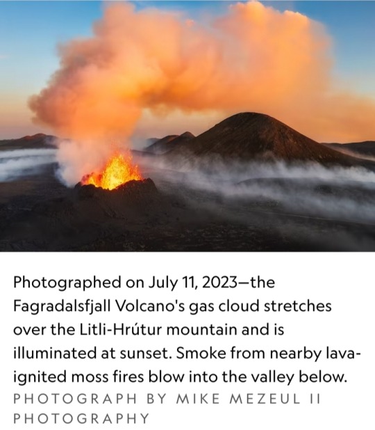
The Fagradalsfjall Volcano, a raised crater of bubbling lava — glowing bright yellow in an expanse of dark gray — is the latest eruption heralding Iceland’s new period of volcanic activity.
The eruption announced its approach on July 4 of this year, when southwest Iceland was rocked by more than 2,000 earthquakes in just 24 hours.
Not long after, seismic activity dropped off as magma rose to shallow depths and ultimately gave way to oozing molten rock on July 10.

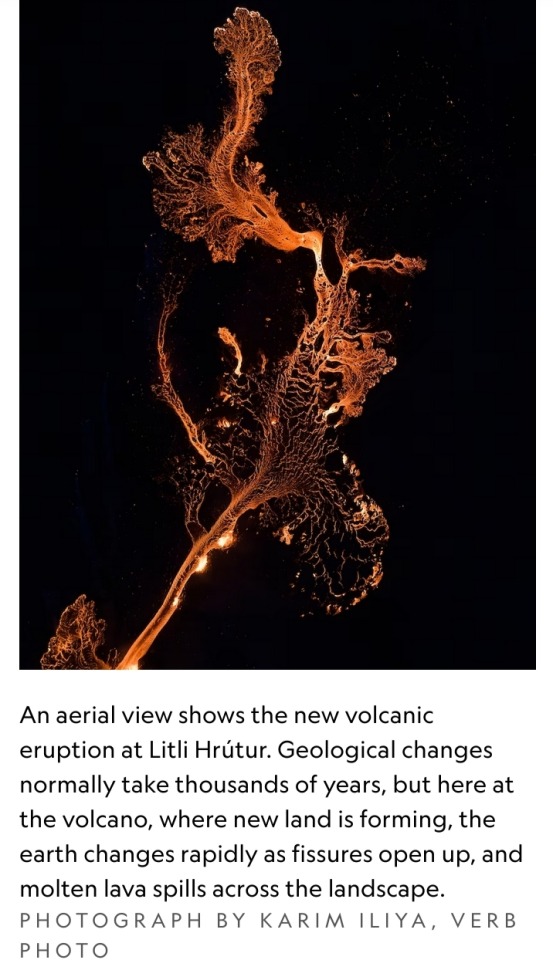
Located next to the small mountain of Litli-Hrútur, this eruption is taking place on Reykjanes, a volcanically active peninsula that has become a popular destination among tourists looking to see lava fountaining above and pouring onto the surface.
However, the site of the new eruption is potentially hazardous — new fissures may open nearby without warning, rivers of lava can form at a quick pace, and toxic gas can quickly fill the air, according to the Iceland Met Office.
This eruption is the peninsula’s third volcanic paroxysm in a row, following on from similar lava-spewing eruptions in 2021 and 2022 — and it’s unlikely to be the last.
After an eruption last summer, Dave McGarvie, a volcanologist at Lancaster University, told National Geographic that the recent uptick in volcanic activity, “... could herald the start of decades of occasional eruptions.”

Iceland’s volcanic geology
The Reykjanes Peninsula lies about 17 miles southwest of Iceland’s capital city Reykjavik.
It sits atop the continually spreading Mid-Atlantic Ridge, where the North American plate to the west and the Eurasian plate to the east are gradually pulling apart.
Superhot, gassy magma, which is less dense than the surrounding rock, can sometimes rise into the shallow crust from buoyancy alone, but all that regional stretching also creates cracks where molten rock can infiltrate.
The peninsula’s subterranean bedlam seems to manifest as periodic busts of volcanism.
Historical accounts and studies of ancient volcanic rocks show that times of volcanic repose transition into loud seismic and eruptive awakenings in a cycle that’s transpired several times in the past few millennia.
Although the region had been volcanically dormant for centuries, the tectonic sundering happening in the depths meant that the latest eruptions have long been in the works.
A fiery new beginning
And in recent years, several sheets of magma ascended toward the surface, indicated by the changing shape of the ground and swarms of earthquakes, says Tobias Dürig, a volcanologist at the University of Iceland.
But for some time, these magmatic serpents failed to see sunlight — their escape was stymied either from the loss of their own upward momentum or because the resilient crust didn’t offer an escape hatch.
Nevertheless, as earthquakes began to crescendo in both frequency and strength from late 2019 onwards, scientists suspected that an eruption sometime in the future seemed inevitable.
That was confirmed in dramatic fashion on 19 March 2021, when lava began gushing from a 1,650-foot-long fissure in a valley of the Geldingadalur region.
These ferocious fires are gifting scientists with an unparalleled look at the connective tissue between the igneous abyss below and the lava-licked landscape above.
Their efforts help improve our understanding of Earth’s viscera, of Iceland’s volcanic cadence, and of this peninsula’s volcanic dangers.

#Fagradalsfjall Volcano#Iceland#Reykjanes#Litli-Hrútur#Reykjavik#Mid-Atlantic Ridge#volcanic activity#volcanic era#volcanic eruption#volcanoes#magma#National Geographic#Nat Geo
5 notes
·
View notes
Text
Iceland’s Reykjanes Peninsula Eruption Forces Evacuations, Sparks Safety Concerns
A powerful volcanic eruption near Grindavík on Iceland’s Reykjanes Peninsula has led to widespread evacuations, including the Blue Lagoon spa. The eruption, which began at 9:45 AM local time, marks the 11th such event since 2021 in this geologically active region.
The Icelandic Meteorological Office (IMO) confirmed that the eruption followed a series of early-morning earthquakes along the Sundhnúkur crater row. By mid-morning, the fissure had extended southward, breaching defensive barriers north of Grindavík and threatening structures on the town’s outskirts. Officials estimate the fissure to be around 1,200 meters long, with lava advancing dangerously close to abandoned buildings.
Authorities swiftly completed the evacuation of Grindavík, although some residents refused to leave despite warnings. The Blue Lagoon luxury spa also cleared all visitors and staff ahead of the eruption. Iceland’s civil protection director, Runólfur Þórhallsson, stressed the importance of evacuation, warning that this eruption could be larger than recent events due to an extended magma tunnel and increased underground pressure.
Seismic activity remains intense, with emergency teams reporting significant fault movements within Grindavík. A ruptured hot water pipeline in the northern part of the town suggests ongoing ground deformation. IMO stated that magma movement appears stronger than in previous eruptions, signaling potential for further expansion of the fissure.
Despite the eruption, Icelandic officials confirmed no immediate risk to air travel, with Keflavík International Airport operating as usual. However, authorities warned of possible gas pollution in localized areas depending on wind patterns. The Icelandic Tourist Board assured visitors that safety precautions were in place, although affected areas remain closed.
Iceland’s tourism sector has proven resilient despite recurring volcanic activity. Following the devastating November 2023 eruption, foreign visitor numbers surprisingly increased by 2% year-over-year, reaching 2.26 million arrivals. Hotel stays also rose, indicating continued global interest in Iceland’s dramatic landscapes.
Looking ahead, experts anticipate continued volcanic activity on the Reykjanes Peninsula, potentially lasting for decades. The fissure-style eruptions characteristic of this region pose ongoing risks, but authorities remain committed to rigorous monitoring and emergency preparedness. As seismic activity persists, Icelandic officials continue to assess the evolving situation, ensuring public safety remains the top priority.
4o
0 notes
Text
Understanding Geopolitics From The Lens Of Arctic

What exactly is Geopolitics ? Why are we concerned about it? Is it really that important? What is the context of geopolitics in our daily lives? I will try to uncover helpful insights and along the way will throw an influx of information that can get us together out of this bucket with a brief dive into the Arctic as a standalone case study, so let’s dissect this topic and receive an insight into the world of geopolitics
Understanding basics
Learning from past mistakes and history has always been a great way to adapt, learn, and Grow! Isn’t it? In ancient times, before settling on a particular location people used to see geographical dynamics such as water nearby, whether the land was fertile or not, less frequent earthquakes, climate changes, etc. It was important then, it is definitely important now. Just the dynamics have shifted a little around. In the next section let’s lay the ground for some basics.
Under the broader umbrella of the world and society, there are politics and geopolitics. Politics is all about what happens inside a country, how people are governed, and how the government makes rules and laws to manage human society. Geopolitics on the other hand is the study of how geographical factors of a particular region will shape its foreign policies, economic drivers, military dynamics, and strategies which leads to deciding its international political behavior through geographical variables.
Importance of why?
We will explore some unknown directions to answer this question - Why is it really important?
Geopolitics is primarily important for planning the future vision of a state, organization, corporation, or institution. By looking at international political behavior and geographical conditions we can make a decision for the future that will either lead to sustainable cooperation or destabilize the ground that might erupt into a chain of conflicts.
While several entities including Governments experience the impact of geopolitics, we can take an example of modern-day businesses. The risks that modern businesses face arise from two main areas: geopolitical and political:
Political risks are those that arise from the actions of the government or people within a country, such as civil war, labor problems, strikes, or expropriation.
Geopolitical risks arise from interactions between countries, such as war, sanctions, trade agreements, energy, or military spending.
The Arctic Case Study
The Arctic region covers parts of eight countries in the world: Canada, Greenland, Iceland, Norway, Sweden, Finland, Russia, and the United States. This area's temperature depends on the region's proximity, but the coldest temperature recorded is -69 degrees. The Arctic is roughly 14 million square kilometers which is covered with water and solid ice, for most of the parts the region is inhospitable. In the coming decades the climate changes will make the resources and passages available in the Arctic more accessible, with abundant resources and land it should come as no surprise that the Arctic will turn into a geographical flashpoint.
Satellite images confirm melting of Arctic Ice is not a surprise, prediction forecasts summertime sea ice will likely completely cease to exist sometime during the 21st century. As the sea levels rise the flooding levels can increase for countries like the Netherlands, Bangladesh, and Maldives, but the limelight will be geopolitical consequences. The three most important resources in the Arctic are minerals, fish stocks, and huge oil and gas reserves, most of which are in Russian territories, including the North Sea in the European territory.
The USA used a geology-based probabilistic method in 2008 to estimate the treasure hidden in the Arctic. The results pointed out that in the north of the Arctic circle, there are roughly 90 billion barrels of oil, 47 trillion cubic meters of natural gas, and around 44 billion barrels of natural gas liquid, which is proportionate to roughly 13% of undiscovered oil and 30% natural gas reserves of the world.
It holds around 22% of the world's undiscovered natural resources, making it a real hotspot for governments and businesses to exploit energy resources. The energy giants like ExxonMobil, Shell, and Rosneft are already competing for the drilling license, however, with the current market energy prices it will not be a profitable affair. The claims of these companies and nations are based on United Nations (UN) convention law. Let's discuss more about this in the upcoming section.
UN Dynamics
The UN Convention Law Of The Sea (UNCLOS) oversees the Arctic region. The Exclusive Economic Zone (EEZ) lies beyond the territorial waters and extends up to 370 km from the shore. However, the EEZ can be extended to 650 km through scientific measurement of the continental shelf. Basically, by providing scientific evidence to measure continental shelf one can extend the EEZ and claim more resources and waters. The territorial disputes are already complicated, yet adding another layer of continental shelf discussion makes it more challenging. Denmark, Russia, the United States, Norway, and Canada have already alleged their claims to the UN. These claims overlap each other and it’s up to the UN to decide in which court the ball will be. The inhospitable weather conditions made these disputes pointless, however, this surprising turn of events in 2007 when the Arctic ice cover was 50% lower than in the 1950s grabbed the spotlight. In the near future as climate change opens up the Arctic, it will become a necessity to settle this dispute by law.
It's not just the natural resources and land debate. These geopolitical dynamics are extended to further issues such as using land routes for transportation. For instance, let’s see a future forecasted dispute. In the current scenario, the maritime traffic between Europe and East Asia is routed through the Panama Canal. As per the current predictions, it is most likely that the maritime traffic will shift to the Arctic Ocean by 2040. A new milestone was set when a cargo vessel went through in 2014 through the northwest passage of the Arctic without the escort of an icebreaker. This passage which connects markets of Europe and East Asia through the Canadian Arctic is nearly 40% shorter than the current route and the waters are deeper allowing vessels to carry more cargo. It is predicted that these passages will be open for nearly 2 months a year around 2040, however with the help of special icebreaker ships this can be extended to a few more months. These passages come under Canada’s internal waters from a legal framework but due to their geopolitical value Russia, the USA, and European countries claim it as internal straits. At present Canada is engaged in legal proceedings to delineate the limits of its continental shelf. Let’s wrap it up!
CONCLUSION
The three main objectives to explore or exploit the Arctic region should be summed up as :
Explore or exploit hydrocarbon and mineral resources.
Establish military bases to claim territory.
Establish authority over new trading routes.
The interests and involvement of such high powers across the world on this particular topic could destroy or develop new threads. Countries and Businesses can leverage the Arctic benefits to gain long-term success in this increasingly competitive global environment.
Join the conversation on IMPAAKT and contribute to impactful discussions shaping our world. Share your insights and make a difference today!
0 notes
Text
Complete Guide to Car Rental Requirements Iceland for Travelling Families In 2025
Hiring a car in Iceland is a great adventure that lets you travel through the country in your own time and with more freedom when touring with kids.
However, it is recommended to see and keep in mind a couple of factors that will give more pleasure in the process. For instance, when choosing a car, it would be worth it to focus on such parameters as the size of the trunk, availability of a child seat, and four-wheel drive if you are going to travel a lot on the F-road.

By carefully planning and preparing, you can make the most of your Icelandic road trip with your family. Here is a small list of all the important information for you!
What Will Travelling Families Need In Iceland In 2025?
· Age and License Requirements
Most car rental companies in Iceland require drivers to be at least 20 years old. However, some companies may have higher age limits, especially for specific vehicle categories like luxury cars or large SUVs. Drivers under this age often incur an additional young driver fee. An International Driving Permit (IDP) is highly recommended, especially if your driver's license is not in English, French, German, Spanish, or Italian.
An IDP serves as an official translation of your driver's license and can be helpful in case of unforeseen circumstances. A valid national driver's license from your home country is also essential.
· Insurance Coverage
These are probably the two most important kinds of insurance coverage: Collision Damage Waiver and Theft Protection. Both cover damage to the car as well as theft, respectively, but come with deductibles attached.
Super CDW and Super TP can be purchased for the rental of Ford Transit Rental Iceland with low or no deductible and the stress of financial loss is removed. One of the most important forms of car rental insurance covers sand and ash. This coverage safeguards the rental car against harm caused by volcanic ash, a major problem in Iceland.
· Winter Driving Considerations
Winter driving in Iceland can be challenging due to icy roads, snowstorms, and limited daylight. Such preparations are necessary. Iceland requires winter tires for winter. Most car rental firms include winter tires with rentals. However, always contact your rental firm for confirmation.
Experience with conditions of winter driving is a must. Be prepared to get into challenging road conditions and drive accordingly.
A 4WD vehicle is highly recommended for excellent winter driving conditions. In general, a 4WD vehicle is going to perform more favorably than other vehicles in handling conditions that are slick such as icy and snowy.
Here you will find the best cheap vehicle rental in our fleet.
· Knowing the Rental Terms & Conditions
Most car rental companies require the driver to be at least 20 years old and charge extra for drivers younger than 25. You will need a valid driver's license from your home country, and an International Driving Permit is recommended if your license is not in English.
Upgrades to Super Collision Damage Waiver (SCDW) and Super Theft Protection (STP) are needed for reduced or zero deductibles. Sand and Ash Protection is vital, especially in the case of volcanic eruptions.
Additional fees may apply, such as airport surcharges and winter tire fees. And these can add up over time even if you selected a cheap car rental Keflavik Airport in the beginning to save cost.
· Fuel Policy to Adhere To
Most of the car rental companies in Iceland will give you the vehicle on full-to-full, meaning the vehicle is to be returned with a full tank of fuel after receiving it with a full tank of fuel. The fuel level will be stated on the rental agreement at the time of picking up the car.
Look at the fuel gauge and ensure that you fill it up before handing it in. A number of the forestry gas stations in the rural parts of Iceland keep such limited hours that it is far more convenient for one to fill up the car in good time before they hand it back.
Some rentals have different fuel policies. Some rental companies may offer alternative fuel policies, such as paying a pre-paid fuel fee. The majority of the rental shops use fueling systems that measure fuel from full-full. Knowledge of fuel policy can effectively ensure that the renting of a car in Iceland experiences no drama.
Our detailed guide to Gas Stations in Iceland provides all the information you need, from current gas prices to tips on using self-service pumps, ensuring you’re well-prepared for your Icelandic adventure.
Click to read the full post and ensure your journey is as smooth and enjoyable.
· Preparing a Travel Kit
When planning a family road trip to Iceland, it's essential to prepare for unexpected situations. Every car should have an emergency kit, especially for the winter season including clothing, a blanket, food and water bottles, a first aid box, a flashlight, and a power bank. The tastes offered by Icelandic food are relatively varied, but it is advisable to carry some biscuits and other edibles in large quests for long travels. But, other concerns such as the diet of preference, food allergies, and restrictions within your family should also be considered.
Such a traveling kit can indeed make you have a good time on your trip and your family will have a very comfortable time. Some useful items include sunscreen, sunglasses, hats, raincoats, and walking shoes with good tread on them.
For kids, you might want to take snacks, candies, toys, etc for children so that they can keep themselves busy when on long journeys. It also recommended that one should also carry a car seat for better transport when carrying a child in the car. The above essentials are helpful for a family road trip planning and organizing while in advance in Iceland.
In Closing…
Having learned these requirements and tips, you can have a safe and fun road trip in Iceland even on crazy winter days. You should always read the conditions of renting provision and precisely check what is allowed in F-roads, and what penalties will be charged in case of returning the automobile late or infringing the requirements.
You must also be aware of the capacities of the car you are renting. For instance, Ford Transit Rental Iceland can open up avenues for many adventures that other base models cannot. All these tips when followed together can give you a trip of a lifetime with negligible worries to deal with!
#airport code kef#Car Rentals Iceland Airport#Car Rental Keflavik International Airport#Cheap Car Rental Keflavik Airport#code for iceland airport#car rentals iceland airport#rent a car iceland airport
0 notes
Link
Volcanoes are not restricted to the land, there are many undersea versions. One such undersea volcano known as Hunga Tonga-Hunga Ha’apai off the coast of Tonga. On 15th January 2022, it underwent an eruption which was one of the most powerful in recent memory. A recent paper shows that seismic waves were released 15 minutes before the eruption and before any visible disruption at the surface. The waves had been detected by a seismic station 750km away. This is the first time a precursor signal has been detected. Undersea volcanoes are openings in the Earth’s crust beneath the ocean, where magma from the mantle escapes, triggering eruptions. They are surprisingly common, with most of Earth’s volcanic activity occurring underwater, particularly along mid-ocean ridges and subduction zones. They play a vital role in creating new seafloor through seafloor spreading, as magma cools and solidifies into basaltic crust. Some grow so tall that they rise above the ocean’s surface, forming volcanic islands such as Iceland and Hawaii. Their eruptions release significant amounts of gas, heat, and minerals into the surrounding water, shaping marine ecosystems. An erupting undersea volcano forms a new island off the coast of Nishinoshima, a small unihabited island in the southern Ogasawara chain of islands. The image was taken on November 21, 2013 by the Japanese Coast Guard. The Hunga Tonga-Hunga Ha’apai volcano is an undersea volcano located in the South Pacific. It became well known after its massive eruption in January 2022. The eruption was one of the most powerful volcanic events of the 21st century, triggering tsunamis that affected coastlines as far away as Japan and the Americas. The explosion released a plume of ash, gas, and water vapour, reaching over 50 kilometres into the atmosphere, making it the highest plume ever recorded. It impacted global weather patterns and temporarily increased water vapour in the stratosphere. The eruption of January 2022 formed a caldera on Hunga Tonga-Hunga Ha’apai. There were disturbances that were recorded by many surface stations and satellites in orbit. The data which had been captured revealed that the eruptions began just after 04:00 UTC on 15 January. There were a number of reports of seismic waves from around 15 minutes before the onset of eruption. In a paper published recently by lead author Takuro Horiuchi and a team from the University of Tokyo, they explore the wave detection and mechanics of the eruption. Volcanic eruptions at Mt. Etna from orbiting NASA Terra Satellite. Acquired on January 11, 2011. NASA Earth Observatory Image of the Day on January 15, 2011. Credit: NASA Terra Satellite The team aim to confirm that the event actually occurred just before the 04:00 published timestamp. If they can confirm this, it will help understand the processes that led to the violent eruption. At the time of the eruption, no seismic stations had been working on Tonga but data had been recorded as far away as Fiji and Futuna, both of which around 750km away from the volcano. The study concluded that the waves which had been detected were Rayleigh waves – a type of seismic waves which are a combination of compression (longitudinal) and shearing (vertical) movements. The waves started around 03:45 on the 15th January 15 minutes before the onset of the eruption. This is the first time significant seismic activity has been seen before the eruption event. It demonstrates that seismic stations hundreds of kilometres away can be positively used to detect signals as precursors to eruptions. Source : A Seismic Precursor 15 min Before the Giant Eruption of Hunga Tonga-Hunga Ha’apai Volcano on 15 January 2022 The post There Was a 15 Minute Warning Before Tonga Volcano Exploded appeared first on Universe Today.
1 note
·
View note
Text
Planet in Fever: Volcanic Catastrophe - A New Threat to Humanity?
The world is shaking. Volcanoes all over the globe are waking up, like giant dragons, spewing fiery breath.
From Etna to Popocatepetl, from Sakurajima to Sangay - the planet is covered with a network of volcanic hot spots that threaten humanity more than ever before.
July 2024 witnessed unprecedented volcanic activity:
= Dukono, Indonesia, 9.07.2024.
= Sangay, Ecuador, 10.07.2024.
= Etna, Italy, 15.07.2024.
= Lewotobi, Indonesia, 20.07.2024.
= Merapi, Indonesia, 20.07.2024.
= Villarrica, Chile, 21.07.2024.
= Bezymianny, Russia, 24.07.2024
= Volcanic eruption on White Island, New Zealand, 26.07.2024.
= Stromboli, Italy, 26.07.2024.
= Sakurajima, Japan, 29.07.2024
= Popocatepetl, Mexico, 28.07.2024
But it is the supervolcanoes that are particularly worrying scientists and local populations.
For example, on July 23, a hydrothermal explosion occurred in Yellowstone National Park in the USA - this was an ejection of underground soil to a height of several meters along with hot water and steam.
Following this, on July 26, Campi Flegrei, Italy, produced an underground tremor with a magnitude of 4.0. The earthquake was recorded at a depth of only 4 kilometers.
Many major cities are located near or directly in volcanic calderas. For example, the city of Kagoshima in Japan is located in the Aira caldera, Naples and Pozzuoli are located in close proximity to the Campi Flegrei caldera in Italy.
And on the territory of Germany there is a huge supervolcano, Laach, which in recent years has also begun to show signs of activity.
The cause of the changes that have been occurring in the bowels of the Earth in recent decades is the increasing magmatic activity, and this is confirmed by the increase in the number of earthquakes in the area of volcanoes and supervolcanoes.
The increase in seismic activity near volcanoes indicates the activation of magmatic processes. That is, the magmatic chambers of volcanoes are filling up and being prepared for a potential eruption.
Given the current atypical magmatic activity in the bowels of our planet, the explosion of one supervolcano will trigger a chain reaction of volcanic explosions, which will lead to a global catastrophe.
Volcanologists today are recording another anomaly: the lava ejected by volcanoes has an atypical composition, characteristic of magma from the deep layers of the mantle.
This is not in vain, because in the last decade there has been an acceleration of the rise of magma from the depths of the earth's crust in many volcanic regions. Such as
= Iceland,
= Italy,
= Mayotte Island in the Indian Ocean,
= La Palma Island (Canary Islands) and others.
This indicates an increase in volcanic activity on a global scale.
Volcanologists are also concerned about the sharp increase in the speed of magma rising from the depths of the Earth. The process of magma rising, which previously took hundreds and thousands of years, is now happening in just six months in some regions.
This is exactly what happened in the Bransfield Strait in 2021, where the rise of magma from a depth of 10 km was accompanied by 85,000 earthquakes. The crust thickness in this area is 15 km, the localization of earthquakes showed that 10 km of crust had already been burned through by active magma and only 5 km remained before its breakthrough to the surface.
The rapid rise of magma from significant depths indicates the emergence of dangerous and previously unobserved processes inside the Earth. The activation of volcanoes suggests that a huge amount of energy has begun to accumulate in the bowels of the planet, which is striving to break out.
As we can see, this is a global threat. It is dangerous for people to ignore these facts. Countries alone cannot cope with the growing climate disaster. Therefore, humanity must urgently create a single scientific center to quickly address climate problems. A comprehensive approach to solving problems is needed.
After all, the lives of people and the sustainability of existing systems are at stake.
It is important to
= identify dangerous locations,
= calculate all the components for carrying out the degassing of volcanoes,
= consider the evacuation of people,
= accommodation locations, rescue forces, logistics routes,
= the safety of food and other systems. All these tasks can only be solved by people working together.
What is happening in the bowels of our planet?
Scientists are recording a rapid rise of magma from the depths of the Earth.
The process that used to take hundreds and thousands of years is now happening in some regions in just six months!
Volcanic activation is not just a natural phenomenon, it is an SOS signal from our planet.
ALLATRA and the volunteers of the Creative Society are people who hear this signal.
We understand that only the combined efforts of all humanity, a scientific breakthrough, and the introduction of new technologies can save us from the impending catastrophe.
We must act before it's too late!
Join us! Together we can change the world!
Spread this information on social media.
Like, repost, comment, and applaud. This is how you save people and the planet.
#ALLATRA #CreativeSociety #Volcanoes #ClimateCrisis #SaveTheEarth #FutureOfThePlanet #ScientificBreakthrough
#ALLATRA#CreativeSociety#Volcanoes#ClimateCrisis#SaveTheEarth#FutureOfThePlanet#ScientificBreakthrough
0 notes
Text
Experience Iceland’s Blue Lagoon with Erupting Volcano View

The Blue Lagoon in Iceland has reopened after a nearby volcano eruption. Authorities confirmed the volcano stabilized, ensuring tourist safety. Oddný Arnarsdóttir, head of Visit Iceland, said security zones were revised, allowing the lagoon to reopen.
Reopening after Volcano Stabilizes
The lagoon, a top tourist spot in southwest Iceland, reopened on June 2, 2024. Hundreds of visitors enjoyed the unique sight of an erupting crater while bathing. Among them were Cameron and Natalie Pacileo from North Carolina. Natalie expressed delight, describing the view as wild and beautiful. The reopened lagoon offered an unforgettable experience with the volcanic backdrop.
Record Lava Levels and Safety Measures
The eruption last Wednesday marked the fifth and strongest since December, releasing record lava levels. The fissure extended to 3.5 kilometers (2.1 miles). The eruption posed a threat to Grindavik, a town of 3,800 people. Authorities evacuated the geothermal spa due to safety concerns. However, they deemed it safe to reopen after reassessing the situation.
Read More:(https://theleadersglobe.com/life-interest/travel/experience-icelands-blue-lagoon-with-erupting-volcano-view/)
#Blue Lagoon#Volcano#global leader magazine#the leaders globe magazine#leadership magazine#world's leader magazine#best publication in the world#article#news#magazine#business
0 notes
Text

Study uncovers first evidence of a volcanic spatter cone on Mars
While working under Erika Rader, an assistant professor in the Department of Earth and Spatial Sciences at University of Idaho, a postdoctoral researcher identified a volcanic vent on Mars as a potential spatter cone and compared it to a spatter cone formed during the 2021 eruption of Fagradalsfjall in Iceland.
The study is published in the journal Icarus.
Through a detailed morphological investigation and ballistic modeling, Ian T.W. Flynn discovered the Martian volcanic feature strongly resembles spatter cones found on Earth.
"Spatter cones are so common on Earth that it seemed extremely unlikely that they simply didn't exist on Mars," Rader said. "Since spatter cones can only form in the right conditions, their presence gives us a benchmark to shoot for when simulating Martian volcanoes."
Spatter cones are created by hot lumps of flying lava falling to the surface during explosive volcanic eruptions, specifically during sustained periods of lava fountaining. They are common features on Earth—including in Idaho, most notably at Craters of the Moon National Monument and Preserve—and have long been suspected to be on Mars as well. However, until now, there wasn't solid evidence of their existence.
"The similarity between the Mars and Icelandic spatter cones indicates that the eruption dynamics occurring in Iceland, over the last several years, also occurred on Mars," Flynn said. "This is exciting as it expands the range of volcanic eruption styles possible on Mars."
This discovery can give us clues about how volcanic eruptions happened on Mars, specifically regarding the gases in the magma and the environmental conditions at the time the eruption occurred. It's also further confirmation that Icelandic—and Idahoan—volcanoes are erupting now the way volcanoes erupted millions of years ago on Mars.
"We are thrilled about this discovery because it fills a distinct observational gap in Martian volcanology, and it lays the groundwork for future investigations of spatter features on Mars," Flynn said.
IMAGE: A volcanic feature on Mars, left, and a spatter cone in Iceland. Credit: Ian T.W. Flynn
6 notes
·
View notes
Text
Gaza City, Forever Palestine 🇵🇸! A woman searches for items to salvage from buildings destroyed in Israeli airstrikes on al-Mukhabarat street. Photograph: AFP/Getty Images

Rafah, Gaza, Forever Palestine 🇵🇸! Smoke billows during an Israeli bombardment. Benjamin Netanyahu confirmed that the Israel Defense Forces had been instructed to commence operations in the southern Gaza city, where the population has been swelled by hundreds of thousands of displaced people. Photograph: Mahmud Hams/AFP/Getty Images

Rafah, Gaza, Forever Palestine 🇵🇸! A woman looks out from the window of a damaged house after an Israeli bombardment. The deadliest round of fighting in the conflict has killed more than 27,000 Palestinians, levelled entire neighbourhoods, driven the vast majority of Gaza’s population from their homes and pushed a quarter of the population to the brink of starvation. Photograph: Mohammed Abed/AFP/Getty Images

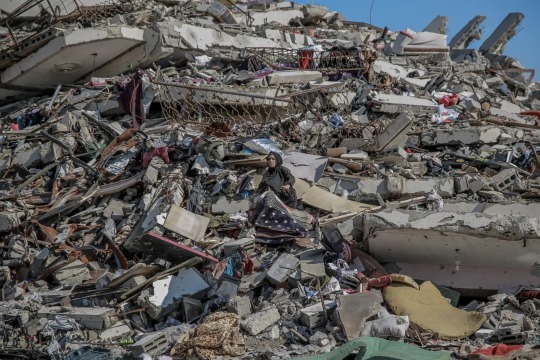
Hatay, Türkiye 🇹🇷! A woman mourns at the grave of a loved one killed during last year’s earthquake. A year ago a 7.8-magnitude earthquake struck southern Turkey, followed by another 7.5-magnitude tremor. The quakes caused widespread destruction in southern Turkey and northern Syria and killed more than 50,000 people. Photograph: Chris McGrath/Getty Images

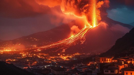
Grindavík, Iceland 🇮🇸! Smoke and lava pouring out of a new fissure during a volcanic eruption on the outskirts of the evacuated town of Grindavík. The lava flow hit thermal-based water pipes in the region just south of the capital, Reykjavík, disrupting the supply of hot water to more than 20,000 people and leading the civil protection agency to raise its alert level to emergency status. Photograph: Icelandic Coast Guard/AFP/Getty Images
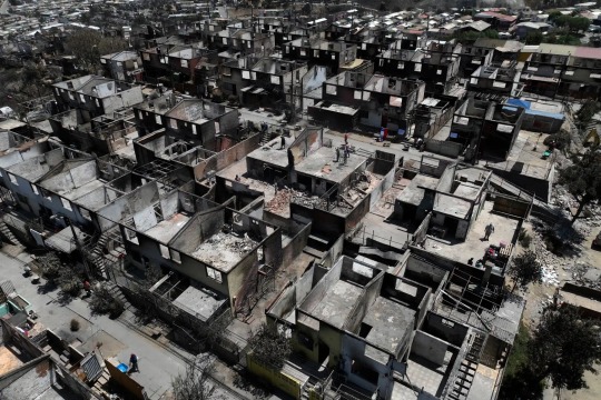
Viña Del Mar, Chile 🇨🇱! Homes destroyed by a wildfire in El Olivar neighbourhood. Chile, Argentina and other parts of South America’s southern cone have been facing a severe heatwave, something experts say will become more common during the southern hemisphere summer months as a result of climate change. Photograph: Javier Torres/AFP/Getty Images

Antarctica 🇦🇶! A whale breaches as a Turkish scientific team continue their voyage during the 8th National Antarctic Science Expedition. Photograph: Sebnem Coskun/Anadolu/Getty Images
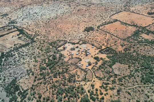
Anosy, Madagascar 🇲🇬! A village in southern Madagascar. The Indian Ocean island country, the first to face food shortages linked to climate change, has experienced poor rains in recent months. As the El Niño climate pattern takes hold, fears of a worsening hunger situation loom large. Photograph: Sarah Tetaud/AFP/Getty Images

Aba, China 🇨🇳! Giant pandas enjoy refreshments at the Shenshuping conservation and research centre. Photograph: VCG/Getty Images

San Vicente, El Salvador 🇸🇻! Officers in riot gear patrol inside a prison. El Salvador’s president, Nayib Bukele, won a resounding victory in elections this week after voters cast aside concerns about the erosion of democracy to reward him for a fierce gang crackdown that has transformed security in the country. Photograph: Alex Peña/Getty Images
#Photographs#Around the Globe 🌎#Gaza#Forever Palestine 🇵🇸#Türkiye 🇹🇷#Iceland 🇮🇸#Chile 🇨🇱#Antarctica 🇦🇶#Madagascar 🇲🇬#China 🇨🇳#El Salvador 🇸🇻
1 note
·
View note