#680 south
Explore tagged Tumblr posts
Visit Tumblr Blog
Explore Tumblr blogs with no restrictions, modern design and the best experience.
Last Seen Tumblr Blogs


Fun Fact
Mobile US users spent an average of 115.8 minutes on Tumblr app monthly.
Text


680 south - the story so far
84 notes
·
View notes
Text
wasted time... MOSTLY MINE!!!!!
0 notes
Text


Ushuaia, Argentina, is nestled between the Martial Mountains and the Beagle Channel near the southernmost tip of South America. Nicknamed “The End of the World,” the city of roughly 75,000 people is 680 miles (1,100 km) from the Antarctic Peninsula. Seen in these Overviews is Ushuaia – Malvinas Argentinas International Airport, the world’s southernmost international airport.
-54.801944°, -68.303056°
Source imagery: Maxar
152 notes
·
View notes
Photo
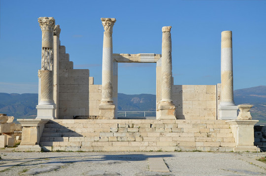
Phrygia
Phrygia was the name of an ancient Anatolian kingdom (12th-7th century BCE) and, following its demise, the term was then applied to the general geographical area it once covered in the western plateau of Asia Minor. With its capital at Gordium and a culture which curiously mixed Anatolian, Greek, and Near Eastern elements, one of the kingdom's most famous figures is the legendary King Midas, he who acquired the ability to turn all that he touched to gold, even his food. Following the collapse of the kingdom after attacks by the Cimmerians in the 7th century BCE, the region came under Lydian, Persian, Seleucid, and then Roman control.
Historical Overview
The fertile plain of the western side of Anatolia attracted settlers from an early period, at least the early Bronze Age, and then saw the formation of the Hittite state (1700-1200 BCE). The first Greek reference to Phrygia appears in the 5th-century BCE Histories of Herodotus (7.73). The Greeks applied the name to the Balkan immigrants who, sometime after the 12th century BCE, relocated to western Anatolia following the fall of the Hittite Empire in that region. The kingdom's traditional founder and first king was Gordios (aka Gordias). A legendary figure, Gordios is most famous today as the creator of the 'Gordian Knot', a fiendishly difficult piece of rope-work the king had used to tether his cart. The story goes that an oracle had foretold that the person who knew how to untie the knot would rule over all of Asia, even the whole world. The cart and the knot were, incredibly, still there at Gordium when Alexander the Great (356-323 BCE) arrived a good few centuries later. Alexander was said to have heard the story and, rather unsportingly, sliced the knot open with a single blow of his sword. In other accounts, the young general slipped the pin out of the cart's yoke pole and slid the knot off that way.
The neighbouring states of Phrygia, which similarly formed out of the remnants of the Hittite Empire, were Caria (south), Lydia (west), and Mysia (north). Phrygia's territory expanded to reach Daskyleon in the north and the western edge of Cappadocia. Phrygia prospered thanks to the fertile land, its location between the Persian and Greek worlds, and the skills of the state's metalworkers and potters. Chamber tombs, especially at the capital Gordium, have distinctive doorways and their excavated contents have revealed both the use of the language of Indo-European Phrygian (from the 8th century BCE) and the wealth which gave rise to the legend of the fabulously rich King Midas (see below).
Phrygia was conquered by the Cimmerians in the 7th century BCE but the period of domination by Lydia and Persia has left an impoverished archaeological record. We know that Lydia expanded under the reign of the Mermnad dynasty (c. 700-546 BCE), and especially King Gyges (r. c. 680-645 BCE). Phrygia was absorbed c. 625 BCE with Gordium conquered around 600 BCE. Lydia then continued to prosper with such famed kings as Croesus (r. 560-547 BCE). Over the next century, the Persians took over Anatolia following the victory of Cyrus II (d. 530 BCE) over the Lydians at the Battle of Halys in 546 BCE. The region was then made a Persian satrapy. Phrygia continued to be used as a label of convenience for the general and ill-defined geographical area which had once been ruled by the now-defunct kingdom of that name.
After the campaigns of Alexander the Great, the region of Phrygia/Lydia came under the control of one of Alexander's successors, Antigonus I (382-301 BCE). Shortly after, Anatolia became a part of the Seleucid Empire c. 280 BCE. As a consequence of this takeover, many settlers came from ancient Macedon and their Hellenistic culture with them. Notable Phrygian towns in this period besides Gordium included Hierapolis, Laodikeia by the Lykos (aka Laodicea), Aizanoi, Apamea, and Synnada, although most of the region's population lived in small, agriculturally-based villages.
Phrygia became a part of the Roman province of Asia (with a part in Galatia, too) in 116 BCE, and the region now grew in scope, at least as a geographical term. To quote the Oxford Classical Dictionary:
During the Roman period the region extended north to Bithynia, west to the upper valley of the Hermus and to Lydia, south to Psidia and to Lycaonia, and east as far as the Salt Lake (1142).
Phrygia then became embroiled in the Mithridatic Wars of the 1st century BCE between Rome and the kings of Pontus. With the reign of Augustus (27 BCE - 14 CE), there followed a period of peace and stability in the region. Prosperity was ensured by the continued fertility of the land and the important marble quarries near Dokimeion - stone from there would be used in such buildings as Trajan's Forum in Rome and the Library of Celsus at Ephesus. Into the 3rd century CE, the culture of the region had become a mix of indigenous Anatolian, Greek, Roman, Jewish, and Christian practices and customs. The Phrygian language, as attested by inscriptions, was still in use in the 3rd century CE, although it is called New Phrygian by historians to distinguish it from the Old Phrygian used when the kingdom itself was in existence (the link between the two was likely created by the language being spoken only as a vernacular in the interim).
Continue reading...
82 notes
·
View notes
Text
Sudan News Reports:
The preliminary committee of the Sudan Doctors Guild has revealed the death of more than 500,000 thousand infants due to malnutrition.
Adiba Ibrahim Al-Sayed, a member of the Omdurman special subdivision of the Preliminary Committee of the Doctors Guild, said that the number of child deaths reached 522 thousand infants, while malnutrition cases have risen to 286 thousand cases since the outbreak of the war until today.
She added that Darfur region has seen the deaths of
45 thousand children due to malnutrition, along with
680 thousand cases of infections among pregnant women with the same disease, in addition to tuberculosis among children in the south of Kordofan.
69 notes
·
View notes
Text

Great White Shark (Carcharodon carcharias)
Habitat & Distribution
Found in the Atlantic, Pacific, and Indian Oceans from Canada and the Mediterranean to South Africa and Aotearoa (New Zealand)
Can reside in open oceans, but is more commonly seen in coastal waters
Physical Description
Weight: 680–1,110 kg (1,500–2,450 lb)
Length: 3.4 to 4.0 m (11 to 13 ft) for males, 4.6 to 4.9 m (15 to 16 ft) for females
Great white sharks are grey with a white underbelly
The body is torpedo-shaped, with a narrow snout and large, triangular fins
Behaviour
In most areas, great white sharks are solitary, but where they do congregate they form hierarchies arranged mainly by size
The diet is varied, consisting of fish, dolphins, seals, sea turtles, squid, whale carcasses and other sharks
Their only known natural predators are killer whales
Key Advantages
Great white sharks have large, sharp teeth designed for grabbing and ripping prey; they have have an incredibly strong bite force, of up to 18,216 newtons (4,095 lbf)
They can swim very fast, up to 50 kph / 35 mph, and can reach top speed in less than two seconds
Photo by Bob Talbot
54 notes
·
View notes
Text

Morning Light on Sengokuhara: Silver Grass and Tradition at Mt. Hakone・仙石原すすき草原:箱根山北麓に広がる、伝統と美の保護
At an altitude of about 700 meters, the vast field of Sengokuhara is blanketed with tall susuki grass (Japanese silver grass, Miscanthus sinensis). Lush and deep green in summer, the grass transforms in early autumn into glistening silvery tufts that sway elegantly in the breeze.
A gently sloping path cuts straight through the field along the northern base of Mt. Daigatake, an inactive lava dome that’s part of the Hakone caldera. This dirt path stretches 680 meters (2,228 feet) across the full width of the slope, leading visitors on an immersive walk through this ocean of silver grass that has been designated as one of Kanagawa’s “50 Best Scenic Spots” and a “Top 100 Flower Viewing Spot.”
While traditionally used for grazing and roofing, Miscanthus species are now valued not only as beautiful ornamentals but also as a candidate for biomass energy resource. Originating in East Asia, these grasses have since spread across North and South America, Europe, Africa, and beyond.
Full write-up with references and Google Maps links (1-minute read): https://www.pix4japan.com/blog/20241015-sengokuhara2
Location: Hakone, Kanagawa Prefecture, Japan Timestamp: 08:05・2024/10/15 Pentax K-1 II + DFA 28-105mm F3.5-5.6 + CP 28 mm ISO 100 for 1/20 sec. at ƒ/11
#風景写真#箱根#仙石原ススキ草原#pix4japan#pentax_dfa28105#pentaxk1mkii#landscapephotography#Japan#Hakone#Sengokuhara
19 notes
·
View notes
Text

Terracotta tile from the 7th century CE found in Vinica, North Macedonia depicts a battle scene between the Bulgars and Slavs with the Latin inscription BOLGAR and SCLAVIGI.
"...on the other hand, the Bulgars have lost their original Turkish language; they now speak the language of the Slav peoples, to the south of the lower Danube, on whom the Bulgars imposed their rule in and after the year 680".
-Arnold Toynbee, Constantine Porphyrogenitus and his World, page 428
#bulgarian#slavic#history#european art#archaeology#europe#art#historical art#middle ages#medieval art#historical linguistics
18 notes
·
View notes
Text
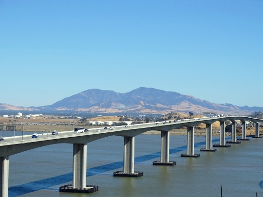

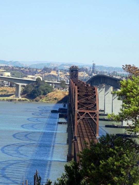
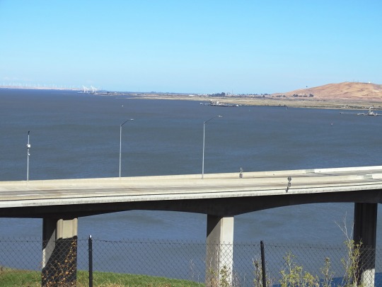


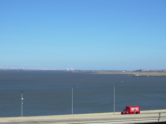
Benicia Bridge Vista Point, CA (No. 1)
The Benicia–Martinez Bridge refers to three parallel bridges which cross the Carquinez Strait just west of Suisun Bay in California; the spans link Benicia on the north side with Martinez on the south.
The original 1.2-mile (1.9 km) deck truss bridge opened in 1962 to replace the last automotive ferry service in the San Francisco Bay Area. The 1962 bridge has seven 528-foot (161 m) spans and 138 feet (42 m) of vertical clearance, now carrying four lanes of southbound traffic, as well as a path for pedestrians and bicyclists. It was named the George Miller Jr., Memorial Bridge in 1975 after California state legislator George Miller Jr. A 1.7-mile (2.7 km) bridge was built alongside and opened on August 25, 2007 with five lanes of northbound traffic. In 2007, it was named the Congressman George Miller Benicia–Martinez Bridge after U.S. Congressman George Miller, Miller Jr.'s son. The cost of the 1962 span was US$25 million and US$1.3 billion for the 2007 span. (Adjusted for inflation, equivalent to $252 million and $1.91 billion respectively.) The bridge is part of Interstate 680, a major transportation link connecting other heavily traveled freeways.
Between the two vehicle bridges is a Union Pacific Railroad bridge, the first bridge at this location, built between April 1929 and October 1930 by Southern Pacific. It is used by Union Pacific and BNSF (trackage rights) freight trains and 36 scheduled Amtrak passenger trains each weekday. Passenger trains include the long-distance trains California Zephyr and Coast Starlight and commuter-oriented Capitol Corridor services.
Source: Wikipedia
#Benicia Bridge Vista Point#Benicia–Martinez Bridge#Grizzly Bay#travel#original photography#vacation#tourist attraction#cityscape#landmark#architecture#summer 2022#nature#flora#Pacific Ocean#George Miller Jr. Memorial Bridge#I-680#Carquinez Strait#Mount Diablo#Union Pacific Railroad's Benicia-Martinez drawbridge#engineering#landscape#seascape#countryside#street scene#road trip#California#West Coast#USA
11 notes
·
View notes
Text
A Public Service
A silly little fic for Linktober 2023 Day 22 Prompt: NPC. Zelda 1. 680 words. Also on ao3. Big thanks to @bellecream for beta-reading!
Link peeked into the cavemouth flickering with torchlight, relieved to see an old man inside and not a moblin. “Oh! Hi. Sorry if I’m intruding-“
“It’s dangerous to go alone,” the old man said.
Link’s mouth snapped shut with a one-eyed squint.
“Take this,” the man continued, offering Link a wooden sword, hilt-first.
“Uh.” Link eyed the meager space, nothing but bare rock, the two torches, and this guy. There wasn’t even a reed carpet for him to sit on. “Do you… live here?” he asked.
The old man appeared not to have any idea what to do next. He continued inching his outstretched hand toward Link, as though proximity was the only reason Link hadn’t already gripped the hilt and charged into the great unknown.
“Why do you have a sword?”
The old man glanced around the cave, a bit of sweat appearing at his temple. “It’s dangerous to go alone.”
“Oookay. Why don’t you go with me, then?”
A nervous grin appeared on the old man’s face. “Ohh, oh no, lad. I should stay here.”
Link blinked at him a few times. “I could… stay with you, then? Do you feel unsafe?”
The man shook his head with vigor. “Of course not!” He threw his head back and laughed three “Ha!”s that sounded more like the guys who’d been running the same mud-show act at the carnival for the past three decades than anything else.
Link stared at him, then at the pommel of the sword. “So… why do you want me to take the sword so bad?”
The old man’s eyes peered all the way to one side, then all the way to the other. “Look, son, just take it.”
“Why?!”
“Don’t you want a sword?”
“Well, sure, I-“
“Then what’s the problem?”
“It’s just weird! Why are you hanging around in an empty cave waiting to hand a sword to the first total stranger who walks in?!”
“Why do you have a shield and no sword, young man? Isn’t that also ‘weird’ as the young’uns say?”
“I’m not standing in a cave waiting to give a rando my shield, am I?!”
“Just take the damn sword!”
“WHY?!”
“Because it’s dangerous to go alone!”
“I’m still alone if I have a sword!!”
“You’re a little safer!”
“You’re not, you’d be alone with no sword and apparently no home either because this sure doesn’t seem like a place of residence!”
“I live two screens south of here in Ordon, thank you very much!”
“Then what the hell are you doing here with that sword?!”
“WAITING TO GIVE IT TO THE NEXT IDIOT YOUNG MAN WHO DECIDES TO GO NORTH INTO THE LIVING HELL CALLED HYRULE!”
“OH SO I’M AN IDIOT, AM I?”
“YOU CERTAINLY SEEM TO BE CONSIDERING YOU BROUGHT A SHIELD AND NO SWORD!”
“A SHIELD’S BETTER THAN NOTHING!”
“A sword and a shield is better than that! NOW TAKE THE DAMN SWORD!” He waggled the hilt in Link’s face with a half-crazed, open-mouthed frown, his breath whistling between his teeth.
Link glared at him with narrow eyes and a curled lip.
The old man’s eyes narrowed right back at him.
Link snatched the hilt and held the sword begrudgingly at his side.
“Good. Now be careful,” the old man said.
“I’ll try.”
Now the old man’s finger was in his face. “NO trying. Do. I’m sick of all these young men off to take the triforce back from Ganon, as if they’re some kind of legendary hero.”
Link went pale.
“Take. Care. Of. Your. Self!” the old man said, each word punctuated by a hard poke of Link’s chest. “If it gets too rough, go home! Royals and their triforces – ha! They can stick them.”
Link blinked. He swallowed.
And he walked out.
The old man sighed, shaking his head as he deflated, his shoulders slouching. “Impa’d better hope I never see her again. What a right old she-wolfos. Single-handedly sending all the younglings off to slaughter.”
He continued muttering to himself as he reached inside his robes and pulled out the next wooden sword to wait.
24 notes
·
View notes
Text
Untouched Horizons Timeline 7/-
Cartography Golden Age
-699
Cartography golden age
With 2 “rival” scouting houses, there’s a competition over who can map the world around them better and faster
This starts a “ship building war” with the advantage to the South and their forests
But the North has the experience
-686
Most of the Caribbean is mapped and charted along with contact made (in some form or another) with other civilizations and indigenous peoples
-684
First contact with the Native Americans along the east coast of America
-681
First ships round South America
-680
Redesign of ships are happening at the same time as both houses (and nations) are copying each other and needing to do deeper sea voyages
-676
Another round of long voyages goes out
The various indigenous peoples start copying the Zlilfian boats they meet/find
-670
Most of the eastern coasts of the Americas have been charted
Starting on exploring up the Mississippi which is proving to be an interesting challenge to rework boats for river travel
-660
Unable to really compete with the North anymore the South starts to own Library of Alexandria to out do the uppercrust schools in the North and to also collect languages and history of the people’s around them
-632
Time for another Northern internal power struggle, this one goes on for a while
-625
Power struggle complete!
The sailing golden age is winding down as a lot of the Americas are mapped, including a decent amount of the riverways charted
Contact established with the people in Peru and Chile and everyone so cotton has been found at the source
Renewed Hostilities
-624
The South really doesn’t care for the new Northern house in charge, they are a bit more authoritarian than before, so they start to chafe
-623
The start of the escalating tensions between countries
The North is doing everything it can to provoke the South into attacking first but it just isn’t working as the South as no united plan to fight wars together
-622
The Southern zones, under extreme pressure from one house Sernlyi, send a formal peace treaty to the North to deescalate tensions
Surprisingly the North agrees as they know that forcing the South to break it first would give them the justification to start their war of conquest
-620
The North really jacked up tariffs on stuff from the South hoping to really stick it to them economically so the South cuts off all northern trade and starts going more outside the island for stuff
This enrages the North
-619
Spies from the South report large sieges works and things being built in the North so the fight to unify the confederacy and form an army is started but is extremely hard and slow going
So the House Sernlyi approves a clandestine strike on the siege works to burn it all down
This infuriates the North further, if they give up the secret that they were building war machines then they’ll have broken the treaty first but the South won’t admit to doing anything and implicating themselves
4 notes
·
View notes
Text
DES MOINES, Iowa (AP) — Floodwaters breached levees in western Iowa on Tuesday, creating dangerous conditions that prompted evacuations as the deluged Midwest faced another round of severe storms forecast for later in the day.
The sheriff’s office in Monona County, south of Sioux City near the Nebraska border, said the Little Sioux River breached levees in several areas. Evacuation orders were issued and roads closed in two small towns, emergency management officials said. No injuries were immediately reported.
“Please stay out of the area for your safety,” the sheriff’s office said in a social media post.
Patrick Prorok, emergency management coordinator in Monona County, described waking people in Rodney, a town of about 45 people, to recommend evacuation about 4 a.m. Later Tuesday morning, the water hadn’t yet washed into the community.
“People up the hill are saying it is coming our way,” Prorok said.
Iowa state transportation officials said they planned to close sections of I-29 and I-680 north of Council Bluffs Tuesday because of rising floodwaters.
The flooding has damaged roads and bridges, closed or destroyed businesses, required hospitals and nursing homes to evacuate, and left cities without power or safe drinking water, the governors of Iowa and South Dakota said. Officials reported hundreds of water rescues.
Severe storms were forecast for Tuesday afternoon and evening with large hail, damaging winds and even a brief tornado or two in parts of western Iowa and eastern Nebraska, according to the National Weather Service. Showers and storms were also possible in parts of South Dakota and Minnesota, the agency said.
The weather service also predicted more than two dozen points of major flooding in southern Minnesota, eastern South Dakota and northern Iowa, and over three dozen points of moderate flooding. Flood warnings are expected to continue into the week.
President Joe Biden approved a major disaster declaration for affected counties in Iowa on Monday, a move that paves the way for federal aid to be granted.
Late Monday in Correctionville, Iowa, the Little Sioux River rose to nearly 31 feet (9.5 meters), about 12 feet (3.7 meters) above flood stage, according to the National Weather Service. About a quarter to a third of residents had evacuated Monday, mayor pro-tem Nathan Heilman said, with homes on the west and south sides of town most affected.
On Tuesday, Heilman said the water was slowly starting to recede, potentially aided by a levee breach downstream.
“That makes everything feel a little bit better,” he said. But there’s still a lot “we’re just kind of waiting to see.”
The flooding in the region, which affected areas from Omaha, Nebraska, to St. Paul Minnesota also came during a vast, persistent heat wave. Dangerous hot, muggy weather was expected again Tuesday around the Omaha area.
Storms last week dumped heavy rains, with as much as 18 inches (46 centimeters) falling south of Sioux Falls, the weather service said.
Places that didn’t get as much rain had to contend with the extra water moving downstream. Many streams, especially with additional rainfall, may not crest until later this week as the floodwaters slowly drain down a web of rivers to the Missouri and Mississippi. The Missouri will crest at Omaha on Thursday, said Kevin Low, a weather service hydrologist.
The heavy rains were blamed in the deaths of at least two people. On Saturday, an Illinois man died while trying to drive around a barricade in Spencer, Iowa. The Little Sioux River swept his truck away, the Clay County Sheriff’s Office said. Officials recovered his body Monday. Another person died in South Dakota, Gov. Kristi Noem said without providing details.
“I’ve never had to evacuate my house,” Hank Howley, a 71-year-old North Sioux City, South Dakota, resident said Monday as she joined others on a levee of the swollen Big Sioux River, where a railroad bridge collapsed a day earlier.
Outside Mankato, Minnesota, the local sheriff’s office said Monday that there was a “partial failure” of the western support structure for the Rapidan Dam on the Blue Earth River after the dam became plugged with debris. Flowing water eroded the western bank.
Eric Weller, emergency management director for the Blue Earth County sheriff, said the bank would likely erode more, but he didn’t expect the concrete dam itself to fail. The two homes downstream were evacuated.
A 2019 Associated Press investigation into dams across the country found that the Rapidan Dam was in fair condition and there likely would be loss of property if it failed. A pair of 2021 studies said repairs would cost upward of $15 million and removal more than $80 million.
5 notes
·
View notes
Photo

Hilda of Whitby
Hilda of Whitby (also known as Saint Hilda of Whitby, l. 614-680 CE) was the founder and abbess of the monastery at Whitby, Kingdom of Northumbria, Britain. She was a Northumbrian princess who converted to Christianity with the rest of the court of her great-uncle, King Edwin of Deira (r. 616-633 CE), when she was 13. She was raised at Edwin's court in the tradition of Roman Catholicism, but at the age of 33 became an adherent of Celtic Christianity, tutored in the faith by Aidan of the monastery of Lindisfarne, and was abbess at Hartlepool Abbey before founding the monastery at Whitby.
She was highly educated and her wisdom was so legendary that her counsel was sought by nobility and commoners alike. Hilda was an able administrator, carefully overseeing the large estate of Whitby while also ministering to the needs of the community. She encouraged the shepherd Caedmon to share the famous hymn which came to him in a vision (Caedmon's Hymn, 7th century CE), the oldest extant poem in Old English, for which she is honored as patron saint of poetry in addition to her honor as patron saint of culture, literacy, and learning.
She hosted and presided over the Synod of Whitby in 664 CE which decided whether the traditions of Celtic or Roman Christianity would be adhered to in Britain and, even when the vote went against her side, stood beside the Church's decision and encouraged unity of vision in adhering to Roman tradition. Her story and Caedmon's Hymn is first recorded by Bede (l. 673-735 CE) in his Ecclesiastical History of the English People (published 731 CE). Hilda's virtuous life, wisdom, and unceasing care for others, no matter their social status, led to her veneration shortly after her death.
Northumbria & Early Life
The Kingdom of Northumbria (c. 604-954 CE) was originally divided between two separate, and hostile, political entities: Bernicia in the north and Deira in the south. These two were in continuous conflict until they were united in 604 CE under the reign of the king Aethelfrith (r. 593-616 CE) of Bernicia.
When Aethelfrith united the kingdoms, he disinherited the ruling house of Deira and drove the Deiran nobility, including Prince Edwin and his nephew Hereric, into exile. Hereric went to the Brittonic kingdom of Elmet (in present-day West Yorkshire) where he and his wife Breguswith had two daughters, Hereswith and Hilda. Hereric was poisoned while at the Elmet court and, after his death, the infant Hilda and her older sister were taken under the care of Edwin who was in exile in East Anglia.
When Aethelfrith died in 616 CE, Edwin returned and claimed the throne, ruling from Deira. Hereswith and Hilda were raised at Edwin's court. The peace established by Aethelfrith was threatened under Edwin by the Kingdom of Mercia at its border and the southern Kingdom of Wessex. In 626 CE, Cwichelm of Wessex (d. 636 CE) sent an assassin to kill Edwin but the plot was foiled and credit was given to the Christian god. Previously, the nobility of Northumbria was pagan but, in gratitude for his life, Edwin – and his entire court including Hilda – converted to Christianity in 627 CE.
Edwin had been victorious over the combined forces of Wessex and Mercia in late 626 CE at the Battle of Win-and-Lose Hill but King Penda of Mercia (r. c. 625-655 CE) turned on his allies, defeated them, and then struck at Northumbria. In 633 CE, Penda defeated the Northumbrians at the Battle of Hatfield Chase in which Edwin and his son Osfrith were both killed. Northumbria's power collapsed and Hilda fled with her mother and sister to Kent. Edwin was succeeded by Oswald (r. 634-642 CE), who devoted himself to turning his people from the religious errors of Roman Catholicism to what he viewed as the self-evident truth of Celtic Christianity.
Continue reading...
92 notes
·
View notes
Text
Submitted via Google Form - Follow Up:
Previous Ask: https://scriptaworld.wordpress.com/2024/03/11/submitted-via-google-form-how-big-can-a-desert-oasis-be/ Oops I sent you a wrong word as English is not my native language. I didn't want to ask about an oasis. I mistakenly thought oasis means fertile region. I wanted to ask how big can a desert fertile region be? I want a large area of fertile land like the Nile river delta.
Tex: To quote from the Wikipedia page:
The Nile Delta (Arabic: دلتا النيل, Delta an-Nīl or simply الدلتا, ad-Delta) is the delta formed in Lower Egypt where the Nile River spreads out and drains into the Mediterranean Sea.[1] It is one of the world's larger deltas—from Alexandria in the west to Port Said in the east, it covers 240 km (150 mi) of Mediterranean coastline and is a rich agricultural region.[2] From north to south the delta is approximately 160 km (100 mi) in length. The Delta begins slightly down-river from Cairo.[3]
The Selenga River’s delta is 680 square kilometers (Wikipedia), and the Ganges River delta is 105,000 square kilometers (Wikipedia). A lot of this depends on how big the river is, as well as other mitigating factors (Wikipedia).
Any other fertile region in a desert environment is likely to be an oasis.
Utuabzu: As I said last time, this already exists in real life in the form of inland deltas and inland seas, and these are often extremely fertile regions. So, you’re good to go. Just make sure it’s an endorheic basin and there’s somewhere for the water to have come from.
6 notes
·
View notes
Text

Footnotes, part 8
[651] Guardian Unlimited
[652] AirWise News
[653] Human Rights Watch, April 16, 2001
[654] Cincinnatti Business Courier
[655] Employment Litigation Reporter, May 29, 2001
[656] May 17, 2001
[657] The Associated Press, June 6, 2001
[658] The Orlando Sentinel, June 12, 2001
[659] The Washington Post, June 2, 2001
[660] Roanoke Times & World News, June 23, 2001
[661] ABC Lubbock Texas
[662] UK Newsquest Regional Press, June 25, 2001
[663] Corp Watch (www.corpwatch.org)
[664] The Cincinnati Enquirer
[665] Public Campaign (www.publicampaign.org/)
[666] The Car Connection (www.thecarconnection.com/)
[667] The New York Times, Dec 24, 2000
[668] Multinational Monitor, July/ August 1999
[669] The Kansas City Star, March 1, 2002
[670] Los Angeles Times, October 1, 1999
[671] Los Angeles Times, October 1, 1999
[672] The Dallas Morning News, July 24, 1997
[673] Associated Press, Sept. 26, 2001
[674] PR Newswire, November 27, 2000
[675] Ethical Investing (www.ethicalinvesting.com/)
[676] Canadian Newswire, December 15, 1998
[677] The Atlanta Journal & Constitution, Oct 31, 2000
[678] Associated Press, Sept. 26, 2001
[679] Mother Jones, July/August 1998
[680] The New York Times, October 25, 1998
[681] The New York Times, November 26, 1998
[682] The New York Times, November 12, 2000
[683] Associated Press, January 22, 2001/ Aug. 6, 2003
[684] The Arizona Republic, January 23, 1999
[685] The Associated Press, January 10, 2001
[686] Mother Jones Magazine, June 14, 1999
[687] PR Newswire, December 1, 1999
[688] The Nikkei Weekly, July 19, 1999
[689] Associated Press, Sept. 26, 2001
[690] Business Wire, April 28, 2000
[691] Public Citizen, October 27, 1999
[692] Providence Journal-Bulletin, October 21, 1999
[693] The AP State & Local Wire, March 7, 2000
[694] AP Online, December 23, 1999
[695] The Associated Press, December 1, 1999
[696] ZDNet
[697] The Chicago Tribune, April 6, 2001
[698] Mother Jones, January 3, 2001
[699] Greenpeace
[700] ATM & Debit News, November 16, 2000
[701] PC Week, January 31, 2000
[702] The AP State & Local Wire, March 12, 1999
[703] Consumer Product Litigation Reporter, Feb. 2000
[704] emagazine.com, march-april 2000
[705] U.S. Newswire, March 6, 2000
[706] Asian Economic News, January 1, 2001
[707] The AP State & Local Wire, April 20, 2000
[708] The Corporation Hall of Shame Report, May 16, 2000
[709] Reuters, May 1, 2000
[710] Associated Press, Sept. 26, 2001
[711] Lycos WebMD
[712] tele.com, July 31, 2000
[713] tele.com, July 31, 2000
[714] tele.com, July 31, 2000
[715] Associated Press, August 2, 2000
[716] The AP State & Local Wire, September 19, 2000S
[717] The Washington Post, September 27, 2000
[718] The AP State and Local Wire, September 13, 2000
[719] The AP State & Local Wire, September 17, 2000
[720] New York Times, September 12, 2000
[721] The Philadelphia Inquirer, September 26, 2000
[722] DailyNews.com
[723] Miami Daily Business Review, October 25, 2000
[724] San Francisco Chronicle, January 14, 2001
[725] Engineering News Record
[726] Las Vegas Review-Journal, October 26, 2000
[727] The New York Times, September 26, 1999
[728] New York Times, October 4, 2000
[729] Abilene Reporter-News, April 5, 2001
[730] New York Times, November 3, 1999
[731] The San Francisco Examiner November 4, 2000
[732] Workers’ Compensation Monitor, November 1, 2000
[733] The AP State & Local Wire, November 7, 2000
[734] The Associated Press, November 21, 2000
[735] The New York Times, November 21, 2000
[736] The Guardian (London), November 3, 2000
[737] Los Angeles Times, November 30, 2000
[738] The Atlanta Journal and Constitution, Nov.11, 2000
[739] South Bend Tribune, November 10, 2000
[740] The AP State & Local Wire, December 10, 2000
#class consciousness#capitalism#class#class struggle#communism#civilization#money#classism#anti capitalism#anti classism#consumption#economics#industrial society#poverty#workers#labor#anarchism#anarchy#anarchist society#practical anarchy#practical anarchism#resistance#autonomy#revolution#anti capitalist#late stage capitalism#daily posts#libraries#leftism#social issues
2 notes
·
View notes
Text

Muslim women pray at the shrine of Shiite Saint Abdulazim during Arbaeen, which ends the 40-day mourning period marking the killing of Imam Hussein, the Prophet Muhammad's grandson, in Karbala in present-day Iraq, in A.D. 680, in Shahr-e-Ray, south of Tehran, Iran, Sunday, Aug. 25, 2024. This year's Arbaeen was shrouded with sadness over the war in Gaza, now in its 11th month, and worries it may expand into a regional conflict with tensions spiking between Israel and Iran. (AP Photo/Vahid Salemi)
3 notes
·
View notes