#vocano
Explore tagged Tumblr posts
Text

Parque natural de los volcanes - Lanzarote - Canary Islands 🌍 4K link
#4k#wallpaper#google earth#satellite view#aerial photography#abstract#texture#aerial art#vocano#crater#black#landscape#volcanic#canary islands#lanzarote#atlas#earth art#earth from space#earth from above#worldview#dji
31 notes
·
View notes
Text
Vintage Volcano
"Atribuyo mis pasiones a la Naturaleza"
Pablo de Rokha
5 notes
·
View notes
Text

Volcanic Vortex Rings occurs when enough pressure builds up so that magma inside the crater propels condensed gases, predominantly water vapor, through the vent.
For a video of Mt Etna’s recent rings, click on the link.
instagram
2 notes
·
View notes
Photo

Source and details.
7 notes
·
View notes
Text
Uncover the Wonders of Volcanic Tourism and Recreation

Volcanic Tourism and Recreation: Exploring the Earth's Fiery Wonders
Imagine standing before a towering volcano, its fiery heart roaring deep within. The air crackles with anticipation, and the ground trembles beneath your feet. This is the allure of volcanic tourism, an exhilarating adventure that takes us to the edge of the Earth's most powerful forces.
From awe-inspiring landscapes to heart-pounding activities, volcanic tourism offers a unique blend of exploration, adventure, and geological marvel. Let's delve into this incredible world, but remember to always prioritize safety and responsible travel practices.
Embracing the Volcanic Experience
Volcanic tourism encompasses various experiences that cater to a wide range of interests:
Geotourism: Embark on a journey through time, exploring volcanic formations and landforms that tell the story of our planet's history.
Adventure Tourism: Seek thrills and challenges with volcano trekking, lava boating, and other adrenaline-pumping activities.
Ecotourism: Discover the delicate ecosystems that coexist with volcanoes, learning about the incredible plant and animal life that thrives in these unique environments.
Safety First: Essential Precautions for Volcanic Exploration
While the allure of volcanoes is undeniable, venturing near active sites requires responsible risk management. Here are some crucial safety tips to ensure a memorable and safe experience:
Assess Risks: Always evaluate potential hazards before embarking on a volcanic expedition. Check for recent volcanic activity, weather forecasts, and any other factors that could impact your safety.
Stay Informed: Keep yourself updated on the latest volcanic activity. Follow expert advice and consult with local authorities to make informed decisions.
Respect Boundaries: Observe restricted areas and avoid taking unnecessary risks. Remember that your safety should always come first.
Types of Volcanic Tourists: Passive vs. Active
In the world of volcanic tourism, there are two distinct types of visitors:
Passive Tourists: These individuals prefer to admire the beauty and power of volcanoes from a safe distance, often opting for guided tours or scenic vantage points.
Active Tourists: Adrenaline seekers and adventure enthusiasts, active tourists venture closer to active eruptions, seeking the thrill of experiencing these natural phenomena up close.
Risk Management for All: Strategies for Passive and Active Tourism
Effective risk management involves tailor-made strategies for both passive and active tourists:
Passive Tourism: Establish clear evacuation routes and communication systems to ensure swift and safe evacuation in case of any activity.
Active Tourism: Provide specialized gear, training, and experienced guides to minimize risks and maximize safety during close-range encounters with active volcanoes.
Benefits of Volcanic Tourism: Beyond the Thrill
Volcanic tourism offers more than just adventure and excitement. It brings a wealth of benefits that extend far beyond the initial experience:
Education: Gain a deeper understanding of geological processes and the history of our planet by witnessing the power of volcanoes firsthand.
Economic Development: Support local communities through tourism revenue, providing vital economic opportunities to areas often overlooked.
Conservation: Promote awareness and appreciation for the importance of protecting volcanic ecosystems, ensuring their preservation for future generations.
Conclusion: Unlocking the Wonders of Volcanoes Responsibly
Volcanic tourism is a captivating field that blends scientific exploration, adventure, and responsible travel. By embracing safety protocols, respecting the environment, and promoting sustainable practices, we can continue to unlock the wonders of these geological marvels while preserving their fragile beauty for generations to come. So, the next time you seek an experience that will leave a lasting impression, consider embarking on a volcanic adventure that will ignite your imagination and connect you with the raw power of nature.
Ready to explore the world's most iconic volcanoes? Check out Famous Volcanoes here.
What are the Risks of Volcano Tourism?
Delving into the world of volcanoes is an exhilarating adventure, but it's essential to acknowledge the potential risks associated with these awe-inspiring natural wonders.
Understanding the Threats
Volcanoes, like unpredictable friends, can become volatile at any moment. Hazards to watch out for include:
Eruptions: The ultimate show of volcanic might, spewing ash, lava, and gases skyward.
Ashfall: A rain of fine particles that can obscure skies, affect breathing, and disrupt transportation.
Gas Emissions: As volcanoes breathe, they release gases like sulfur dioxide and hydrogen sulfide, which can cause respiratory distress.
Lahars: Mudflows composed of volcanic ash, debris, and water, capable of crushing everything in their path.
Lava Flows: Rivers of molten rock that can engulf landscapes and leave behind a trail of destruction.
Pyroclastic Flows: Fast-moving clouds of hot volcanic gases and ash, as deadly as they sound.
Geysers and Hot Springs: Sizzling and bubbling pools that can cause burns or scalding if approached recklessly.
Mitigating the Hazards
To ensure a safe and enjoyable volcano tourism experience, destinations implement comprehensive safety measures:
Evacuation Plans: Clearly defined routes and communication systems for rapid evacuation in case of an emergency.
Safety Training and Gear: Equipping tourists with the necessary knowledge and equipment to respond to potential hazards.
Volcanic Monitoring: Keeping a watchful eye on volcanic activity and providing regular updates to visitors.
Safety Regulations: Enforcing rules and restricting access to high-risk areas to protect both tourists and the environment.
Personal Safety
As a volcano tourist, your safety is paramount. Here's what you can do:
Study Up: Get familiar with the volcano you're visiting, its history, and recent activity. It's like having an insider's scoop on the mountain's mood!
Stay Informed: Keep track of any warnings, alerts, or changes in volcanic activity. Don't be caught off guard by Mother Nature's unpredictable nature.
Follow the Rules: Stick to designated trails and boundaries, and always obey instructions from park rangers and local authorities. They know the volcano best.
Be Prepared: Pack essential gear like a flashlight, whistle, and first aid kit in case of emergencies. Think of it as your volcanic adventure survival kit!
Balancing Safety and Adventure
Volcano tourism is a unique blend of adventure and safety. By understanding the risks and taking appropriate precautions, you can embark on an unforgettable journey to these geological marvels without compromising your well-being. So, get ready for an adventure that's both thrilling and safe!
What are the benefits of volcano tourism?
Volcano tourism, a fascinating adventure, invites you to witness the wonders of our Earth's geological masterpieces. Discover why this extraordinary experience should top your travel bucket list:
1. Unforgettable Adventures:
Imagine standing on the edge of an active volcano, feeling the rumble beneath your feet and the heat radiating from its core. Volcano tourism offers a once-in-a-lifetime chance to hike through breathtaking volcanic landscapes, explore geothermal hot springs that pulsate with vibrant colors, and witness the awe-inspiring spectacle of volcanic eruptions. These adventures ignite a blend of excitement, wonder, and a profound understanding of nature's power.
2. Educational Explorations:
Delve into the realm of geology and earth sciences as you uncover the secrets whispered by volcanic formations, lava flows, and volcanic processes. Volcano tourism serves as a living classroom, providing hands-on experiences that enrich your knowledge of our planet's dynamic evolution.
3. Nature's Canvas Revealed:
Volcanic landscapes paint a vibrant tapestry of nature's artistry. From the rugged grandeur of lava plateaus to the lush greenery of crater lakes, each volcano unveils its own unique story. Witness the shaping forces of fire and earth, showcasing the beauty and diversity of our planet's geological wonders.
4. Economic Empowerment:
Volcano tourism extends its benefits beyond the thrill-seekers and nature enthusiasts. It supports local communities through job creation in geotourism, adventure tourism, and ecotourism. By promoting sustainable practices that protect the fragile ecosystems surrounding volcanic regions, volcano tourism contributes to their economic well-being.
5. Environmental Stewardship:
Visiting volcanoes ignites a deep respect for the power of nature and the importance of conservation. It encourages responsible tourism practices and fosters awareness about the preservation of these geological masterpieces for generations to come. Volcano tourism inspires a greater appreciation for the interconnectedness of our natural world and the need to protect its delicate balance.
Key Takeaways:
Volcano tourism offers an exhilarating blend of adventures, educational opportunities, and stunning natural beauty.
It empowers local economies and promotes sustainable practices that protect volcanic ecosystems.
Volcanoes draw people from all walks of life, captivating their curiosity, fueling their thirst for adventure, and inspiring their scientific minds.
Volcano tourism fosters environmental awareness, highlighting the significance of biodiversity conservation and responsible tourism practices.How to Plan a Safe and Responsible Volcano Tourism Trip
Feel the Earth's Might Safely and Ethically
Embracing the allure of volcanoes can be thrilling, but it's vital to tread cautiously. Here's a step-by-step guide to help you embark on a safe and respectful volcano tourism experience:
Plan Ahead Like a Pro
Before you lace up your hiking boots, take these preparatory measures:
Get the Inside Scoop: Visit local tourism websites and contact volcano observatories for the latest safety updates, restricted areas, and expert insights.
Safety First - Every Step of the Way
Once you're on the volcano's doorstep, prioritize these safety measures:
Stay Informed: Keep an ear to the ground for any activity updates. If officials issue warnings, heed them promptly.
Listen to the Locals: Park rangers and other experts know the volcano like the back of their hand. Trust their guidance and stay within designated safe zones.
Respect the Volcano: Don't push your luck by venturing into restricted areas, especially near active craters.
Be a Responsible Voyager
As a mindful traveler, embrace these ethical practices:
Tread Lightly: Stick to marked trails. Don't stray off the path or trample on delicate vegetation.
Pack In, Pack Out: Carry all your trash and leave the volcano as pristine as you found it.
Support Local: Patronize local businesses and lodgings to promote sustainable tourism and boost the community's economy.
Remember These Key Points
Research Thoroughly: Know the volcano's activity patterns and potential risks before you go.
Heed Safety Guidelines: Follow the rules and avoid unnecessary danger.
Practice Responsible Tourism: Respect the environment and support local communities.
Stay Updated: Monitor volcano activity and be prepared to alter your plans if necessary.

FAQ
Q1: What are the geological hazards associated with volcano tourism?
A1: Volcano tourism involves exploring active and dormant volcanoes, which pose inherent risks. Volcanic hazards to be aware of include eruptions, ash fall, lava flows, pyroclastic flows, gas emissions, lahars and mudflows, extreme hot springs, geysers, and fumarolic vents. Proper planning and preparation are essential to minimize these risks.
Q2: How can I stay safe while participating in volcano tourism?
A2: Safety should be a top priority during volcano tourism. Educate yourself about the volcano you're visiting by researching its history, potential hazards, and safety guidelines. Adhere to all safety regulations, heed warnings from local authorities, and avoid taking unnecessary risks.
Q3: What are the different types of tourism activities associated with volcanoes?
A3: Volcano tourism encompasses various types of tourism activities. Geotourism focuses on the educational and scientific aspects of volcanic regions. Adventure tourism includes thrilling activities such as hiking, climbing, and exploring lava caves around volcanoes. Ecotourism promotes responsible travel that supports conservation efforts in volcanic ecosystems.
Q4: How does volcano tourism benefit local communities?
A4: Volcano tourism can positively impact local economies through geotourism, adventure tourism, and ecotourism. Tourists visiting volcanic destinations bring revenue to local businesses, create employment opportunities, and support the development of infrastructure. It can also promote cultural exchange and raise awareness of the importance of volcanic conservation.
Q5: What are the ethical considerations associated with volcano tourism?
A5: Engaging in responsible volcano tourism involves respecting the local environment, wildlife, and cultural heritage of volcanic regions. Avoid disturbing or damaging natural formations, observe wildlife from a distance, and be mindful of noise and pollution. Additionally, support local communities by using their services, products, and accommodations.
0 notes
Text
Mount St. Helens Isn't Where It Should Be. Scientists May Finally Know Why.
The Volcano is Responsible for the Deadliest Eruption in the U.S., Yet Many Mysteries Remain About the Closely Watched Peak, Including Why it Formed in the First Place.
— By Maya Wei-Haas | Graphics By Diana Marques | Published: May 18, 2020 | September Wednesday 25, 2024

The gaping crater of Mount Saint Helens, seen here on September 5, 2019, is a reminder of the deadly volcanic blast that rocked the Pacific Northwest 40 years ago. Photograph By Amanda Lucier, The New York Times Via Redux
The frosty volcanic peaks of the Pacific Northwest stand in a remarkably straight line, rising from the crumpled landscape east of Interstate 5. But one volcano is conspicuously out of place. More than 25 miles to the west of the other explosive peaks, in the southwest corner of Washington State, sits Mount St. Helens.
It’s been 40 years since Mount St. Helens famously roared to life, sending ash and gas 15 miles high, flattening 135 square miles of forest, and killing 57 people in the country’s deadliest eruption. Today, the volcano is still one of the most dangerous in the United States, and the most active of the Cascade Range.
Where all this firepower comes from, however, has been an enduring mystery. The volcano’s defiant position out of line perches it atop a zone of rock too cold to produce the magma necessary to feed its furious blasts.
“There shouldn’t be a volcano where Mount St. Helens is,” says Seth Moran, scientist-in-charge at the U.S. Geological Survey’s Cascades Volcano Observatory in Vancouver, Washington.
Solving this puzzle is about more than satisfying geologic curiosity. The firestorm 40 years ago was a reminder of the dangers the Cascade volcanoes pose to millions of people—and a hard shove propelling volcanology into the future. In the decades since, scientists have used the extensive observations of that blast to better understand eruptions around the world, and bolster our readiness for those yet to come.

© NGP, Content may not reflect National Geographic's current map policy. Source: USGS
“This was a fundamental leap forward in our understanding of this style of eruption,” says Janine Krippner, a volcanologist with Smithsonian’s Global Volcanism Program.
Crucially, a more detailed view of the volcano’s inner workings could help researchers better track the shudders and shifts that foreshadow an eruption, potentially helping to hone volcanic forecasts and get people out of harm’s way.
Four decades after Mount St. Helens’ eruption, scientists finally are unearthing some clues to its curious position. In one of the most comprehensive efforts to trace a volcano’s roots, the Imaging Magma Under St. Helens project, or iMUSH for short, used a slew of analyses to bring these subterranean secrets to light. Overall, the volcano doesn’t follow the textbook picture of a peak sitting above a chamber of molten rock. Instead, it seems, a diffuse cloud of partially molten blobs lingers deep below the surface, offset to the east of the edifice, toward the neighboring Mount Adams.

A column of searing ash and gas rises from Mount St. Helens on May 18, 1980, seen here from the southwest. Less than two weeks after the eruption, some of this volcanic ash had drifted all the way around the world. Photograph By Corbis Via Getty Images
View From The Sky
On the crisp, clear morning of May 18, 1980, geologists Dorothy and Keith Stoffel were soaking up glorious views of Mount St. Helens from the air. As a special treat for Dorothy’s upcoming 31st birthday, the pair had secured permission from the USGS to charter a flight over the volcano. It had been rumbling for nearly two months, but the mountain was almost tranquil early that Sunday. When Dorothy called the USGS to check if the flight was a go, she was told: “Come on over, there’s nothing happening here.”
Usually covered in snow and glaciers, Mount St. Helen’s white flanks had been blackened by the volcano’s recent burbles. The pair snapped pictures of the symmetrical peak from the windows of the Cessna 182. “It was so calm and serene, I almost felt a sense of disappointment,” Dorothy recalls. “In my mind, I thought, Oh, the mountain’s become dormant again.”
A swollen bulge that protruded from its northern flank was one of the few visual reminders of its active state. Since late March of that year, the bulge had grown six and a half feet each day. As the Stoffels flew by, Dorothy spotted glistening white tracks of melted ice rolling down the volcano’s ashen face, a sign of the intense heat just below the surface. The plane then looped across the sky, eventually making two passes over the volcano’s crater.
At 8:30 a.m., they decided to make one last arc heading east above the bulge. That was when the volcano suddenly unraveled.
Faster than they could comprehend what was happening, a crack more than a mile long split the mountain, and the north side collapsed in the largest landslide ever recorded above water. The pair continued snapping images as the ground seemed to liquify, and more than 0.6 cubic miles of material—enough to fill a million Olympic swimming pools—churned downslope.
“As a geologist, you expect volcanoes to erupt,” Dorothy says. “You do not expect mountains to instantly fall apart.”
“As A Geologist, You Expect Volcanoes To Erupt. You Do Not Expect Mountains To Instantly Fall Apart.”
— Dorothy Stoffel, Retired Geologist
The landslide released the pressure on the magma building below—like popping the cork of a champagne bottle—and the volcano let loose. Billowing clouds of hot rock jetted northward in a massive sideways blast, the first of its kind observed in detail. Traveling as fast as 300 miles an hour, the explosion sheared the peak off the volcano, and wreaked devastation across hundreds of square miles.
Swelling clouds from the sideways blast began to overtake the Stoffels’ plane. The pilot dropped into a nosedive to gain speed. “I really thought our lives were over,” Dorothy says. But by veering south, the trio narrowly escaped.
As they retreated, Dorothy watched the plume of searing gas and ash billow skyward, flashes of volcanic lightning illuminating the crater. For more than nine hours, the plume towered over the volcano, blanketing the region in ash and blotting out the sun.

A helicopter drops off equipment at Mount St. Helens to monitor for potential activity. The array of instruments that keep close watch on the volcano has undergone multiple upgrades since the 1980 eruption. Photograph By Adam Mosbrucker, USGS
The Stoffels’ harrowing account is a vital piece of information among the numerous observations of the explosive event recorded by both citizens and scientists. Nearly 34 miles to the east, on Mount Adams, climber John Christiansen, raised his ice ax to the sky. The air was so electric, it shocked him through his woolen mitten. Some 45 miles to the southwest, on Oregon’s Sauvie Island, artist Lucinda Parker and her husband tracked the roiling plume as their three-year-old daughter played in the sand. More than 145 miles to the east, Douglas Bird and his family were leaving for church when he spotted the approaching clouds laden with ash, unlike anything he’d seen before.
The power of the blast has echoed through generations and brought researchers from around the world to Washington State to study the volcano. The iMUSH project was, in part, born from this intense fascination.
Peering Into The Deep
Mount St. Helens is a member of the Cascadia volcanic arc, which stretches from British Columbia to Northern California. Similar to many volcanoes around the world, this simmering range is the product of a subduction zone, a tectonic collision where, in this case, a dense oceanic plate plunges beneath a more buoyant continental plate. As the slab descends, pressures and temperatures climb, and fluids percolate out of the slab, triggering the solid mantle rocks to melt. Less dense than its surroundings, this molten magma shoves its way upward through the crust, creating volcanoes.
Most of the Cascade volcanoes—and others around the world—take shape above the spots where the plunging slab descends to roughly 62 miles deep, where temperatures get high enough for magma to form. But the situation is different at Mount St. Helens. Standing tens of miles to the west of other volcanoes, the infamous peak perches a mere 42 miles above the subducting plate.
The iMUSH project kicked off in the summer of 2014 in part to try and solve this conundrum. To craft images of the subsurface, scientists can study the speed at which seismic waves travel and their path underground; it’s not unlike taking a planetary ultrasound. Battling flat tires and unmaintained dirt roads, dozens of researchers assembled to deploy a fleet of seismometers all over the volcano’s flanks.
“As Far As The Group Was Able To Do, The Kitchen Sink Got Thrown At St. Helens.”
— Seth Moran, USGS Cascades Volcano Observatory
For one part of the analysis, the researchers detonated a series of blasts and watched the waves roll in. Another set of instruments recorded every tremble around the peak—such as the rumble of ocean waves and earthquakes on the other side of the world—for two years. Other researchers tackled the system by studying the chemistry of the rocks themselves. And still more scientists used Earth’s magnetic and electric fields to map out the conductivity of the subsurface.
“As far as the group was able to do, the kitchen sink got thrown at St. Helens,” says the USGS’s Moran, who was part of the iMUSH team.
The results show that seismic waves creep along slowly in a zone east of Mount St. Helens, some 10 to 25 miles deep. Differences in minerals can influence the speed of seismic waves, but magma can be another source of this sluggishness. Perhaps rocks melt as expected near the rest of the Cascade volcanoes, the analysis suggests, but some diverts westward to squeeze through the subsurface and feed Mount St. Helens.
The story from the rocks themselves fits with this picture. By melting samples of erupted rock under a variety of conditions in the lab, the team revealed that the sticky gas-rich magmas that give Mount St. Helens eruptions their punch form at a depth similar to the proposed reservoir, says Dawnika Blatter, an experimental petrologist on the iMUSH team who works with the USGS’ California Volcano Observatory.
The surprising offset of this magma “suggests we need to look more broadly than just right below a volcano if we’re going to understand where the magma is coming from,” says Geoffrey Abers, a geophysicist at Cornell University who was part of the iMUSH seismic analyses.
After the 1980 eruption, researchers may have even caught trembles from nearby this deep melt zone, as the earth adjusted to the draining of molten rock. For nearly a year after the blast, Moran says, tremors rumbled to the southeast of the peak. Subterranean shifts in magma can produce quakes around volcanoes, so knowing whether these tremors are in fact linked to Mount St. Helens’ magma pockets could help direct future monitoring efforts.
“We’ve known that the southeastern side of St. Helens is a little bit of a weak spot in the network,” Moran says. “Having insight into reasons why earthquakes are occurring out there gives more impetus to improving that side of the volcano.”
Mount St. Helens Sits Oddly Apart From The Other Cascade Volcanoes.
Ancient scars in the subterranean landscape may explain its unusual position, directing magma along
an unexpected route.
Million years ago, tectonic plate collisions sent a plateau called Siletzia inching toward ancient North America.
62-56 Million Years Ago

As the ocean between the two landmas-ses closed, sediments from the seafloor were scraped into a heap beneath the surface and squeezed into stone. This process formed what’s known as meta-sedimentary rock.
50-44 Million Years Ago

Meta-sedimentary rock Sinking ocean crust: The metasedimentary rock may have created a weak zone in the crust that helped molten rock rise to the surface. Some 20 million years ago, a massive slug of such melt pushed its way through, crystallizing and solidifying as a batholith.
28-18 Million Years Ago.

Analyses of Mount St. Helens hint that today, the magma originates from a zone of partially molten rock to the east. The different properties of the Spirit Lake batholith and the surrounding meta-
sedimentary rocks may alter the region’s geologic stresses, guiding magma west-ward to the oddly offset volcano.
Present Day
Mt. Adams. Mt. St.Helens. Batholith Fluid Release Drives Melting of Mantle Rocks Subducting Oceanic Plate:

Diana Marques, National Geographic Staff. Source: Paul Bedrosian, USGS; Alan Levander, Rice University
Ancient Scars
The choreographer of this magmatic dance is still being debated. Many scientists see clues in the surrounding landscape, which bears scars from millions of years of tectonic jostling that could help direct the modern flow of molten rock.
A volcanic plateau known as Siletzia once sat off North America’s west coast. But Earth’s continuous tectonic shifting slowly closed the gap, and some 50 million years ago, Siletzia collided with the continent. As the ocean between the two landmasses closed, seafloor sediments were scraped into a heap beneath the surface and squeezed into stone. According to the iMUSH team, this indelible tectonic suture may lie just beneath Mount St. Helens.
The scientists sketched out structures from this merger using a method known as Magnetotellurics, which tracks the conductivity of rocks. Minerals that are carbon- and sulfur-rich, similar to those that might form from marine sediments, “light up like a Christmas tree,” says Paul Bedrosian, a geophysicist with the USGS and a member of the iMUSH team. Sure enough, just beneath Mount St. Helens, a swath of such illumination marks the region where ancient marine sediments were turned into a particular rock type called metasedimentary.
The analysis unveiled another surprise just to the east of the volcano: A vast area of low-conductivity rock sits just above where deep magma may pond. The scientists believe this rock is a slug of now-cooled magma that formed millions of years before Mount St. Helens was born.
The differences in the properties of this volcanic plug, known as a batholith, and the metasedimentary rocks of the suture zone may alter the stresses in the region and thus direct the magma flow. The batholith limits magma from rising to the east of Mount St. Helens; the metasedimentary rocks could serve as a relief valve, drawing the volcano’s sticky, viscous magma to the surface.
A dense wall of rock beneath these metasediments, also revealed by the seismic array, may actually be part of this lost landscape, providing a westward stop for the flow of magma, says Jade Crosbie, a geophysicist with the USGS in Lakewood, Colorado, and part of the iMUSH team.
Navigating a Sea of Data
While the iMUSH analyses help sharpen our view deep inside the planet, the picture remains far from complete, Moran says. “One of the general rules in geophysical imaging is the deeper you go, the less you know.”
youtube
VOLCANOES 101. About 1,500 active volcanoes can be found around the world. Learn about the major types of volcanoes, the geological process behind eruptions, and where the most destructive volcanic eruption ever witnessed occurred.
Today, the remains of Siletzia can be seen only piecemeal at the surface, partially buried by flows of now solidified lava and soils studded with trees. This leaves scientists debating where the suture zone—and its role in magmatic direction—precisely lies. To actually put your hand on Siletzia rocks, you’d have to travel tens of miles to the west of Mount St. Helens, says seismologist Eric Kiser of the University of Arizona, who was an iMUSH team member.
As the researchers continue to sort through the sea of other data from iMUSH, many more questions dance in their heads. How does the system change over time? How quickly does the magma move? How does such a vast zone of partly melted rock focus into a volcanic pinprick on the surface? Each potential answer helps shape our understanding of how and why volcanoes erupt, which can help researchers connect what happens at one volcano to the broader picture of volcanism around the world, says seismologist Helen Janiszewski of the University of Hawaii at Manoa.
Since that fateful day in 1980, Mount St. Helens has awoken multiple times, even as the population living in its shadow has grown. That confluence reinforces the need to keep close watch on this particular peak, and scientists have embraced that task.
“Mount St. Helens is being monitored really well,” Kiser says. “The USGS people, they’ve got that under control.”
#Youtube#Geology#Volcanoes 🌋#Natural Disasters#Mount St. Helens#Scientists#United States 🇺🇸#Maya Wei-Haas#Graphics | Diana Marques#Deadliest Eruptions#Vocanoes Mysteries
24 notes
·
View notes
Text

Finished reading Heaven official’s blessing. It’s so damn romantic! I can’t help but be moved by their journey. Still, there’re so many side plots that still not properly cleared up and I really want to know more.
#hua cheng#xie lian#tian guan ci fu#heaven official's blessing#i want to know more about#mu qing and feng xin resolved? conflict?#hua cheng’s story in details during his time in the vocano and how e ming was forged#ling wen hx with the cursed brocade#he xuan and shi qingxuan!!#pei ming and yushi huang no i dont want romance btw them i just wanna see how they become platonic friends#quan yizhen and omg poor yin yu so so many misunderstandings i want a happy ending for them too#no i dont wanna know anything more about qi rong lol#tgcf#mxtx tgcf#mxtx#san lang#hualian fanart#danmei#hualian
101 notes
·
View notes
Text
youtube
Hydrothermal explosions at Yellowstone
3 notes
·
View notes
Text
youtube
#fall out boy#i've listened to this dozens of times#this performance is PERFECT#immortals and young vocanoes in acoustics are to die for#patrick is a sweet cinnamon roll#love them love them love them#Youtube
2 notes
·
View notes
Text
Four Stops on Big Island Hawaii
Hawaii Island, or Big Island, is the largest of Hawaii’s island chain. That means there is a lot to see and do on Big Island. We’ll tell you four stops to make on Big Island. We’ll also give you some ideas of places to stay. And we’ll let you know the auto tour app we use on all of our Big Island travels. Mauna Kea Visitors Information Center a look from Mauna Kea Visitors Information Center at…

View On WordPress
0 notes
Text
Discovering Kilauea Volcano Hawaii
Come discover the active volcano Kilauea on the Big Island, Hawaii. We will examine the crater / caldera, walk through a lava tube, get up close to a town and are destroyed by Kilauea volcano, check out some lava trees, pull out the thermo camera, and mor
Come discover the active volcano Kilauea on the Big Island, Hawaii. We will examine the crater / caldera, walk through a lava tube, get up close to a town and are destroyed by Kilauea volcano, check out some lava trees, pull out the thermo camera, and more. Learn more in the video by Epic Earth YouTube: Read more about this subject

View On WordPress
1 note
·
View note
Text
Will ChatGPT Replace Web Developers?
As technology continues to advance at an unprecedented pace, the role of artificial intelligence (AI) in various industries has become a topic of great interest and speculation. In the field of web development, the emergence of AI-powered language models such as ChatGPT has raised the question: can these technologies eventually replace web developers? In this article, we explore this intriguing topic and delve into a remark from Clifford Matamba, the CEO of Digital Vocano, a prominent web hosting company.

The Rising Potential of ChatGPT in Web Development
ChatGPT, developed by OpenAI, represents a significant leap in AI language models. It possesses the remarkable ability to comprehend and generate human-like text, including snippets of code. By leveraging vast amounts of training data, ChatGPT can assist developers in designing web applications, generating code, and providing valuable insights.
The Limitations and the Indispensability of Web Developers
Despite the impressive capabilities of ChatGPT, it is important to recognize the limitations of AI language models. While ChatGPT can provide assistance, it is not equipped with the creative, problem-solving abilities, and contextual understanding that web developers possess. Web development involves much more than writing code, as it also entails designing user-friendly interfaces, optimizing website performance, ensuring security, and solving complex technical challenges. These aspects require a high level of expertise, experience, and adaptability that an AI-powered language model alone cannot replicate.
Digital Vocano's CEO Remarks on the Role of ChatGPT
Clifford Matamba, the CEO of Digital Volcano, believes that while ChatGPT and similar language models have their merits, they cannot fully replace web developers. In his remark, Matamba emphasizes the vital role that developers play in creating unique and personalized web experiences for businesses and users. He acknowledges that AI-powered language models can be helpful in automating certain mundane tasks and streamlining the development process. However, he firmly asserts that the creativity, problem-solving skills, and deep understanding of client requirements that web developers possess are crucial and irreplaceable.
Matamba also highlights the complex nature of web development, pointing out that it extends beyond mere coding. Web developers are responsible for staying up-to-date with the latest tools, frameworks, and industry trends. They possess the necessary expertise to optimize websites for search engines, ensure cross-platform compatibility, and address user experience challenges. These multifaceted skills enable developers to create innovative and tailored solutions that align with a company's brand and objectives.
Conclusion
While AI language models, like ChatGPT, have undoubtedly demonstrated their potential in aiding web developers, it is unlikely that they will replace them entirely. Web development requires a range of skills that go beyond generating code snippets. Developers bring their expertise, problem-solving abilities, and creativity to create unique, high-performing web applications. Clifford Matamba's remark emphasizes the indispensability of web developers in the ever-evolving landscape of technology. Instead of replacing developers, AI can complement and assist them, leading to more efficient and productive workflows in the field of web development.
1 note
·
View note
Text

Vocano disposable vape by VapeCloud is now available with 7500 velvety puffs 🤩💨
Pre-filled with tantalizing and refreshing flavours of e-liquid with 50mg nicotine strength. Vocano is ready to deliver smooth and satisfying nicotine hit on the go 😎
With more puffs, you're sure to enjoy the next level of vaping with Vocano 7500 puffs. Get your hands on one of these while in stock 😉
Price: $29.99 | Buy 2 for $55 ���
Rechargeable disposable vape | 50mg nicotine level | Available in five fruity flavours | 40 VG / 60 PG
Available in-store and at vapecloud.co.nz
Come visit us in-store or at the website! 😉
Website: https://vapecloud.co.nz
Instagram: @vapecloudnz
Address: 2/117 Cascades Road, Pakuranga Heights, Auckland 2010, New Zealand Phone: +64 210 264 0908
🔞 Please note that you must be at least 18 years old in order to make a purchase with us.
0 notes
Text

Silvia Lermo, Cuando dormíamos sobre volcanes IV (When We Slept on Vocanos), 2022
Acrylic on canvas, 97 x 130 cm
54 notes
·
View notes
Text

So there was this Goodbye Vocano High fan game that was pretty popular. Y'know the one. You play as a closeted trans woman, and the dinogang helps you come out? Anyone else remember it?
#goodbye volcano high#dinosaur#archosaurs#velociraptor#micoraptor#aquilops#fang gvh#rosa gvh#sage gvh#fuck snoot game#transgender#trans pride
8 notes
·
View notes
Text
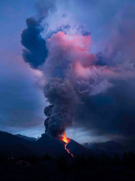
A view of Cumbre Vieja Volcano from El Paso against a purple-blue sky. On the afternoon of September 19, the Cumbre Vieja volcano roared to life, spewing molten rock down its flanks and sending a column of ash billowing skyward. The Island's abundant Volcanoes are fed by a plume of hot rock that extends deep underground.
Dramatic Photos Show La Palma Volcano’s Ongoing Eruption
“I Never Dreamed About Being So Close To Something Like This,” Says Photographer Arturo Rodríguez. “It’s So Big, So Powerful.”
Photographer Arturo Rodríguez was taking a shower at his home in Tenerife, the largest of the Spanish Canary Islands, when he heard an alarmed voice blare from the TV in the next room. "It just erupted! It just erupted—I can't believe it!" the reporter yelled into the camera.
In the weeks leading up to that fateful September day, a swarm of earthquakes had rattled the neighboring Island of La Palma, hinting at the movement of magma under the surface. Rodríguez, who was born and raised in La Palma, was preparing for a trip to photograph scientists as they monitored the island's volcanoes, which had slumbered for the past 50 years. And then one roared awake.
Rodriguez rushed out of the shower to change his flight and made it to the island a few hours later. That night, he snapped photos as fountains of lava shot from the Cumbre Vieja volcanic ridge, casting an eerie glow over nearby towns. The volcano's roar filled his ears, like waves crashing on a cliff. Glassy shards of ash rained from the skies, and the scent of spoiled eggs permeated the air.
“I Never Dreamed About Being So Close To Something Like This,” He Says. “It’s So Big, So Powerful.”
So far, the ongoing eruption has destroyed more than 2,500 buildings and displaced thousands of people. Ash has fallen in thick layers, collapsing roofs and burying agricultural lands—and the lava has paved over everything in its path. "This monster erupted in the middle of the most populated area," Rodríguez says. "I can feel the pain of all the people here."
That pain became particularly acute when Rodríguez spotted his cousin among crowds of people he was photographing as they packed up to flee the encroaching lava. He put down his camera and rushed to help his cousin hastily pack belongings in boxes.
Now, two months after the first glowing lava emerged, the volcano continues its fiery blasts, and Rodríguez fears for his home island's future. The economy depends in large part on banana farming, but hundreds of acres of land once used to grow bananas have become entombed in lava. Many of the banana trees that have survived are covered in ash that mars the fruits' skin, which makes it impossible for farmers to export their crops.
Some people are now moving away, their homes and livelihoods buried in rock. The years ahead remain uncertain, Rodríguez says. "It's going to be rough for the island."
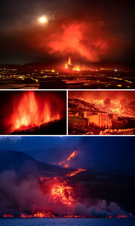
Over the course of the eruption, lava emerged from multiple points along a deep fracture in the volcanic ridge, sweeping across the island into nearby cities. Rodríguez arrived the day the eruption began, snapping the image on the bottom left during his first night. Photographs By Arturo Rodríguez
On September 28, nine days after the first blast, lava began flowing into the sea. The reaction between the sizzling hot rock and cold seawater generated laze—a noxious plume of steam laced with hydrochloric acid and shards of volcanic glass.
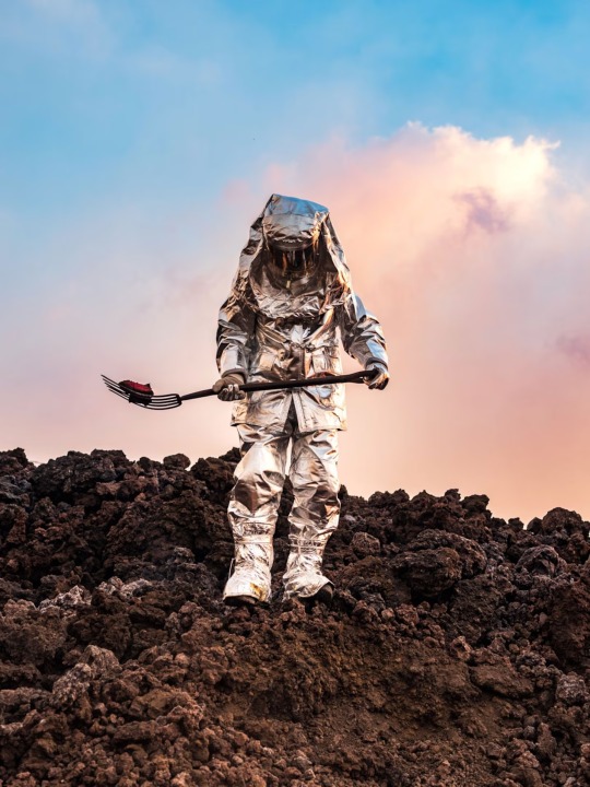
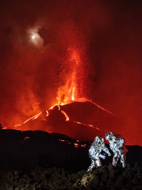
Scientists Have Collected Samples of Rock, monitored gasses, recorded earthquakes, and more to better understand the current eruption and the potential for more blasts. In this image, Sergeant Armando Salazar, who is part of an emergency response group with the Spanish military, wears a silver suit for protection against the volcano's scorching heat as he walks across the still-sizzling rocks.
Risking Their Lives For Science: Equipped like spacemen, in silver suits to protect them from lava and sizzling rocks, these researchers take measurements in the shadow of a still-erupting volcano.

Top: The ash that emerges from volcanoes is composed of shards of rock and glass. In some places on La Palma, the ash has built up so much that it's buried trees (shown above) and houses, some of which only have chimneys left poking through the volcanic blanket.
Bottom: Scientists from IGME and CSIC (the Spanish geological survey and National Research Council) are seeking any possible clues to better understand what's happening under the surface. A lava tube that formed in 1949 sits less than four miles away from Cumbre Vieja, so scientists placed gas sensors in the older tube to sniff out fractures that might connect to the ongoing eruption.
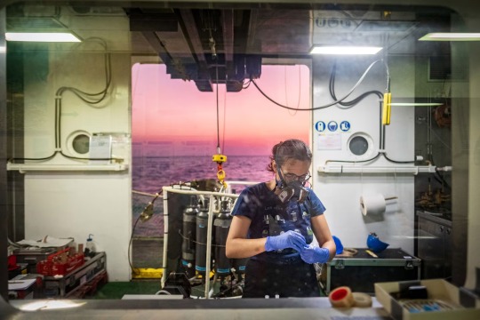
The night lava reached the ocean, scientists with the Spanish Institute of Oceanography studied the activity from the vessel Ramon Margalef. Since then, the eruption has built up a growing lava delta of jet-black rock.
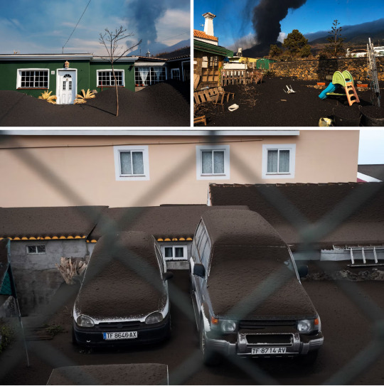
The volcanic ash can build up so much that it causes roofs to collapse. Many people added extra support inside their houses, propping up their roofs with extra pillars of wood, Rodríguez says. Volunteers and public workers continue cleaning off roofs every day, but it's taxing and potentially dangerous work.
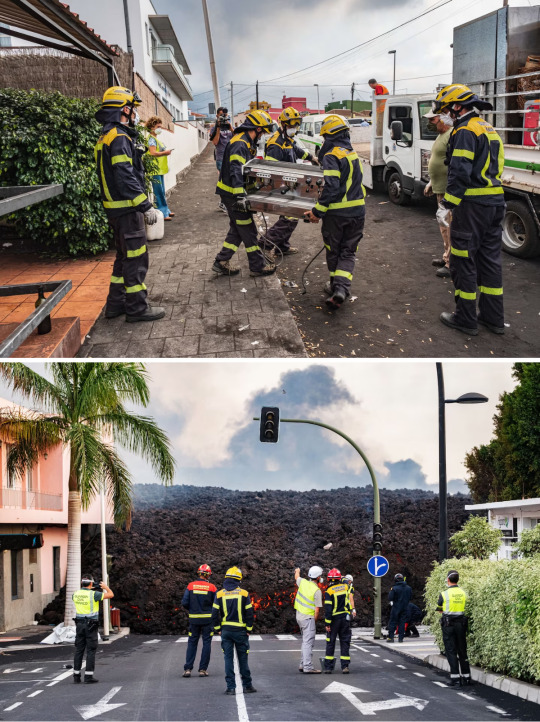
Top: Rodríguez ate breakfast each morning at a cafe near a banana plantation. One morning, he arrived to find volunteers helping move equipment from the restaurant to save whatever they could from the encroaching lava.
Bottom: Lava from Cumbre Vieja reached the village of La Laguna (above) at the end of October. In just a few hours, it had buried half the neighborhood. "There used to be a supermarket, a gas station," Rodríguez says. "Now there is nothing there. There's lava."
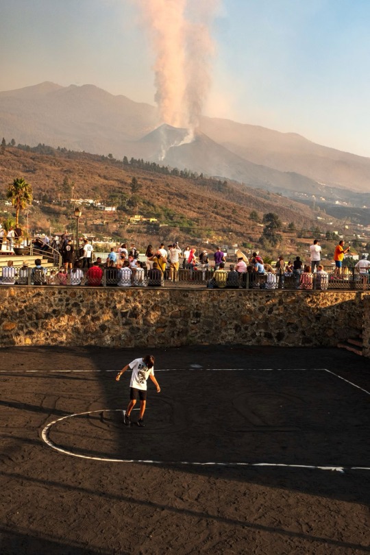
Locals and tourists watch the eruption from Tajuya Church, which is located almost two miles from the fiery peak. Meanwhile, a boy clears ash from the lines of a basketball court to play. "This is a relatively safe place to see the volcano," Rodríguez says.
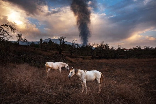
Two months after the Cumbre Vieja volcano rumbled to life, molten rock continues to flow from the fiery peak. Scientists do not yet know when the eruption might come to an end.
#Vocanoes#Volcanology#Volcanologists#Geology#Farms#Natural Disasters#Spanish Canary Islands 🇮🇨#Arturo Rodríguez#Cumbre Vieja Volcano 🌋 | El Paso#Island of La Palma#Science#Scientists#Village of La Laguna
6 notes
·
View notes