#Volcanoes 🌋
Explore tagged Tumblr posts
Text
Mount St. Helens Isn't Where It Should Be. Scientists May Finally Know Why.
The Volcano is Responsible for the Deadliest Eruption in the U.S., Yet Many Mysteries Remain About the Closely Watched Peak, Including Why it Formed in the First Place.
— By Maya Wei-Haas | Graphics By Diana Marques | Published: May 18, 2020 | September Wednesday 25, 2024

The gaping crater of Mount Saint Helens, seen here on September 5, 2019, is a reminder of the deadly volcanic blast that rocked the Pacific Northwest 40 years ago. Photograph By Amanda Lucier, The New York Times Via Redux
The frosty volcanic peaks of the Pacific Northwest stand in a remarkably straight line, rising from the crumpled landscape east of Interstate 5. But one volcano is conspicuously out of place. More than 25 miles to the west of the other explosive peaks, in the southwest corner of Washington State, sits Mount St. Helens.
It’s been 40 years since Mount St. Helens famously roared to life, sending ash and gas 15 miles high, flattening 135 square miles of forest, and killing 57 people in the country’s deadliest eruption. Today, the volcano is still one of the most dangerous in the United States, and the most active of the Cascade Range.
Where all this firepower comes from, however, has been an enduring mystery. The volcano’s defiant position out of line perches it atop a zone of rock too cold to produce the magma necessary to feed its furious blasts.
“There shouldn’t be a volcano where Mount St. Helens is,” says Seth Moran, scientist-in-charge at the U.S. Geological Survey’s Cascades Volcano Observatory in Vancouver, Washington.
Solving this puzzle is about more than satisfying geologic curiosity. The firestorm 40 years ago was a reminder of the dangers the Cascade volcanoes pose to millions of people—and a hard shove propelling volcanology into the future. In the decades since, scientists have used the extensive observations of that blast to better understand eruptions around the world, and bolster our readiness for those yet to come.

© NGP, Content may not reflect National Geographic's current map policy. Source: USGS
“This was a fundamental leap forward in our understanding of this style of eruption,” says Janine Krippner, a volcanologist with Smithsonian’s Global Volcanism Program.
Crucially, a more detailed view of the volcano’s inner workings could help researchers better track the shudders and shifts that foreshadow an eruption, potentially helping to hone volcanic forecasts and get people out of harm’s way.
Four decades after Mount St. Helens’ eruption, scientists finally are unearthing some clues to its curious position. In one of the most comprehensive efforts to trace a volcano’s roots, the Imaging Magma Under St. Helens project, or iMUSH for short, used a slew of analyses to bring these subterranean secrets to light. Overall, the volcano doesn’t follow the textbook picture of a peak sitting above a chamber of molten rock. Instead, it seems, a diffuse cloud of partially molten blobs lingers deep below the surface, offset to the east of the edifice, toward the neighboring Mount Adams.

A column of searing ash and gas rises from Mount St. Helens on May 18, 1980, seen here from the southwest. Less than two weeks after the eruption, some of this volcanic ash had drifted all the way around the world. Photograph By Corbis Via Getty Images
View From The Sky
On the crisp, clear morning of May 18, 1980, geologists Dorothy and Keith Stoffel were soaking up glorious views of Mount St. Helens from the air. As a special treat for Dorothy’s upcoming 31st birthday, the pair had secured permission from the USGS to charter a flight over the volcano. It had been rumbling for nearly two months, but the mountain was almost tranquil early that Sunday. When Dorothy called the USGS to check if the flight was a go, she was told: “Come on over, there’s nothing happening here.”
Usually covered in snow and glaciers, Mount St. Helen’s white flanks had been blackened by the volcano’s recent burbles. The pair snapped pictures of the symmetrical peak from the windows of the Cessna 182. “It was so calm and serene, I almost felt a sense of disappointment,” Dorothy recalls. “In my mind, I thought, Oh, the mountain’s become dormant again.”
A swollen bulge that protruded from its northern flank was one of the few visual reminders of its active state. Since late March of that year, the bulge had grown six and a half feet each day. As the Stoffels flew by, Dorothy spotted glistening white tracks of melted ice rolling down the volcano’s ashen face, a sign of the intense heat just below the surface. The plane then looped across the sky, eventually making two passes over the volcano’s crater.
At 8:30 a.m., they decided to make one last arc heading east above the bulge. That was when the volcano suddenly unraveled.
Faster than they could comprehend what was happening, a crack more than a mile long split the mountain, and the north side collapsed in the largest landslide ever recorded above water. The pair continued snapping images as the ground seemed to liquify, and more than 0.6 cubic miles of material—enough to fill a million Olympic swimming pools—churned downslope.
“As a geologist, you expect volcanoes to erupt,” Dorothy says. “You do not expect mountains to instantly fall apart.”
“As A Geologist, You Expect Volcanoes To Erupt. You Do Not Expect Mountains To Instantly Fall Apart.”
— Dorothy Stoffel, Retired Geologist
The landslide released the pressure on the magma building below—like popping the cork of a champagne bottle—and the volcano let loose. Billowing clouds of hot rock jetted northward in a massive sideways blast, the first of its kind observed in detail. Traveling as fast as 300 miles an hour, the explosion sheared the peak off the volcano, and wreaked devastation across hundreds of square miles.
Swelling clouds from the sideways blast began to overtake the Stoffels’ plane. The pilot dropped into a nosedive to gain speed. “I really thought our lives were over,” Dorothy says. But by veering south, the trio narrowly escaped.
As they retreated, Dorothy watched the plume of searing gas and ash billow skyward, flashes of volcanic lightning illuminating the crater. For more than nine hours, the plume towered over the volcano, blanketing the region in ash and blotting out the sun.

A helicopter drops off equipment at Mount St. Helens to monitor for potential activity. The array of instruments that keep close watch on the volcano has undergone multiple upgrades since the 1980 eruption. Photograph By Adam Mosbrucker, USGS
The Stoffels’ harrowing account is a vital piece of information among the numerous observations of the explosive event recorded by both citizens and scientists. Nearly 34 miles to the east, on Mount Adams, climber John Christiansen, raised his ice ax to the sky. The air was so electric, it shocked him through his woolen mitten. Some 45 miles to the southwest, on Oregon’s Sauvie Island, artist Lucinda Parker and her husband tracked the roiling plume as their three-year-old daughter played in the sand. More than 145 miles to the east, Douglas Bird and his family were leaving for church when he spotted the approaching clouds laden with ash, unlike anything he’d seen before.
The power of the blast has echoed through generations and brought researchers from around the world to Washington State to study the volcano. The iMUSH project was, in part, born from this intense fascination.
Peering Into The Deep
Mount St. Helens is a member of the Cascadia volcanic arc, which stretches from British Columbia to Northern California. Similar to many volcanoes around the world, this simmering range is the product of a subduction zone, a tectonic collision where, in this case, a dense oceanic plate plunges beneath a more buoyant continental plate. As the slab descends, pressures and temperatures climb, and fluids percolate out of the slab, triggering the solid mantle rocks to melt. Less dense than its surroundings, this molten magma shoves its way upward through the crust, creating volcanoes.
Most of the Cascade volcanoes—and others around the world—take shape above the spots where the plunging slab descends to roughly 62 miles deep, where temperatures get high enough for magma to form. But the situation is different at Mount St. Helens. Standing tens of miles to the west of other volcanoes, the infamous peak perches a mere 42 miles above the subducting plate.
The iMUSH project kicked off in the summer of 2014 in part to try and solve this conundrum. To craft images of the subsurface, scientists can study the speed at which seismic waves travel and their path underground; it’s not unlike taking a planetary ultrasound. Battling flat tires and unmaintained dirt roads, dozens of researchers assembled to deploy a fleet of seismometers all over the volcano’s flanks.
“As Far As The Group Was Able To Do, The Kitchen Sink Got Thrown At St. Helens.”
— Seth Moran, USGS Cascades Volcano Observatory
For one part of the analysis, the researchers detonated a series of blasts and watched the waves roll in. Another set of instruments recorded every tremble around the peak—such as the rumble of ocean waves and earthquakes on the other side of the world—for two years. Other researchers tackled the system by studying the chemistry of the rocks themselves. And still more scientists used Earth’s magnetic and electric fields to map out the conductivity of the subsurface.
“As far as the group was able to do, the kitchen sink got thrown at St. Helens,” says the USGS’s Moran, who was part of the iMUSH team.
The results show that seismic waves creep along slowly in a zone east of Mount St. Helens, some 10 to 25 miles deep. Differences in minerals can influence the speed of seismic waves, but magma can be another source of this sluggishness. Perhaps rocks melt as expected near the rest of the Cascade volcanoes, the analysis suggests, but some diverts westward to squeeze through the subsurface and feed Mount St. Helens.
The story from the rocks themselves fits with this picture. By melting samples of erupted rock under a variety of conditions in the lab, the team revealed that the sticky gas-rich magmas that give Mount St. Helens eruptions their punch form at a depth similar to the proposed reservoir, says Dawnika Blatter, an experimental petrologist on the iMUSH team who works with the USGS’ California Volcano Observatory.
The surprising offset of this magma “suggests we need to look more broadly than just right below a volcano if we’re going to understand where the magma is coming from,” says Geoffrey Abers, a geophysicist at Cornell University who was part of the iMUSH seismic analyses.
After the 1980 eruption, researchers may have even caught trembles from nearby this deep melt zone, as the earth adjusted to the draining of molten rock. For nearly a year after the blast, Moran says, tremors rumbled to the southeast of the peak. Subterranean shifts in magma can produce quakes around volcanoes, so knowing whether these tremors are in fact linked to Mount St. Helens’ magma pockets could help direct future monitoring efforts.
“We’ve known that the southeastern side of St. Helens is a little bit of a weak spot in the network,” Moran says. “Having insight into reasons why earthquakes are occurring out there gives more impetus to improving that side of the volcano.”
Mount St. Helens Sits Oddly Apart From The Other Cascade Volcanoes.
Ancient scars in the subterranean landscape may explain its unusual position, directing magma along
an unexpected route.
Million years ago, tectonic plate collisions sent a plateau called Siletzia inching toward ancient North America.
62-56 Million Years Ago

As the ocean between the two landmas-ses closed, sediments from the seafloor were scraped into a heap beneath the surface and squeezed into stone. This process formed what’s known as meta-sedimentary rock.
50-44 Million Years Ago

Meta-sedimentary rock Sinking ocean crust: The metasedimentary rock may have created a weak zone in the crust that helped molten rock rise to the surface. Some 20 million years ago, a massive slug of such melt pushed its way through, crystallizing and solidifying as a batholith.
28-18 Million Years Ago.

Analyses of Mount St. Helens hint that today, the magma originates from a zone of partially molten rock to the east. The different properties of the Spirit Lake batholith and the surrounding meta-
sedimentary rocks may alter the region’s geologic stresses, guiding magma west-ward to the oddly offset volcano.
Present Day
Mt. Adams. Mt. St.Helens. Batholith Fluid Release Drives Melting of Mantle Rocks Subducting Oceanic Plate:

Diana Marques, National Geographic Staff. Source: Paul Bedrosian, USGS; Alan Levander, Rice University
Ancient Scars
The choreographer of this magmatic dance is still being debated. Many scientists see clues in the surrounding landscape, which bears scars from millions of years of tectonic jostling that could help direct the modern flow of molten rock.
A volcanic plateau known as Siletzia once sat off North America’s west coast. But Earth’s continuous tectonic shifting slowly closed the gap, and some 50 million years ago, Siletzia collided with the continent. As the ocean between the two landmasses closed, seafloor sediments were scraped into a heap beneath the surface and squeezed into stone. According to the iMUSH team, this indelible tectonic suture may lie just beneath Mount St. Helens.
The scientists sketched out structures from this merger using a method known as Magnetotellurics, which tracks the conductivity of rocks. Minerals that are carbon- and sulfur-rich, similar to those that might form from marine sediments, “light up like a Christmas tree,” says Paul Bedrosian, a geophysicist with the USGS and a member of the iMUSH team. Sure enough, just beneath Mount St. Helens, a swath of such illumination marks the region where ancient marine sediments were turned into a particular rock type called metasedimentary.
The analysis unveiled another surprise just to the east of the volcano: A vast area of low-conductivity rock sits just above where deep magma may pond. The scientists believe this rock is a slug of now-cooled magma that formed millions of years before Mount St. Helens was born.
The differences in the properties of this volcanic plug, known as a batholith, and the metasedimentary rocks of the suture zone may alter the stresses in the region and thus direct the magma flow. The batholith limits magma from rising to the east of Mount St. Helens; the metasedimentary rocks could serve as a relief valve, drawing the volcano’s sticky, viscous magma to the surface.
A dense wall of rock beneath these metasediments, also revealed by the seismic array, may actually be part of this lost landscape, providing a westward stop for the flow of magma, says Jade Crosbie, a geophysicist with the USGS in Lakewood, Colorado, and part of the iMUSH team.
Navigating a Sea of Data
While the iMUSH analyses help sharpen our view deep inside the planet, the picture remains far from complete, Moran says. “One of the general rules in geophysical imaging is the deeper you go, the less you know.”
youtube
VOLCANOES 101. About 1,500 active volcanoes can be found around the world. Learn about the major types of volcanoes, the geological process behind eruptions, and where the most destructive volcanic eruption ever witnessed occurred.
Today, the remains of Siletzia can be seen only piecemeal at the surface, partially buried by flows of now solidified lava and soils studded with trees. This leaves scientists debating where the suture zone—and its role in magmatic direction—precisely lies. To actually put your hand on Siletzia rocks, you’d have to travel tens of miles to the west of Mount St. Helens, says seismologist Eric Kiser of the University of Arizona, who was an iMUSH team member.
As the researchers continue to sort through the sea of other data from iMUSH, many more questions dance in their heads. How does the system change over time? How quickly does the magma move? How does such a vast zone of partly melted rock focus into a volcanic pinprick on the surface? Each potential answer helps shape our understanding of how and why volcanoes erupt, which can help researchers connect what happens at one volcano to the broader picture of volcanism around the world, says seismologist Helen Janiszewski of the University of Hawaii at Manoa.
Since that fateful day in 1980, Mount St. Helens has awoken multiple times, even as the population living in its shadow has grown. That confluence reinforces the need to keep close watch on this particular peak, and scientists have embraced that task.
“Mount St. Helens is being monitored really well,” Kiser says. “The USGS people, they’ve got that under control.”
#Youtube#Geology#Volcanoes 🌋#Natural Disasters#Mount St. Helens#Scientists#United States 🇺🇸#Maya Wei-Haas#Graphics | Diana Marques#Deadliest Eruptions#Vocanoes Mysteries
24 notes
·
View notes
Text

ᴀɴᴅʏ ᴡᴀʀʜᴏʟ Vesuvius. 1985.
#andy warhol#pop art#volcano#art history#20th century#1980s#80s#lgbt#art#earth#science#vesuvius#landscape#mountains#fire#mountain#italy#pompeii#geology#nature#🌋
103 notes
·
View notes
Text


Everything you have, I will now take from you.


Everything you thought you were, I have proven you are not.


A fight is about who's left standing. Nothing else.
#kazuya mishima#tekken 1#tekken bloodline#tekken 7#tekken#happy t7 fated retribution day!!!!#aka heihachi death day#it's interesting to me how in the cliff toss ones kaz is cocky smiling but in the volcano one he looks contemplative#that sure is a thing i could analyze!!!#had to swap the 3rd and 4th bloodline gifs around to maintain the layout parallels i was going for#prayin the html doesn't break again on this kazuya volcano party morning#🌋🌋🌋
57 notes
·
View notes
Note
🌋 winter draws curtains closed, but in my world, curtains drop. what’s to be revealed lies under the fallen frost. melt away, and you will see me.
🌋
77 notes
·
View notes
Photo

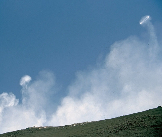
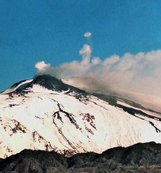
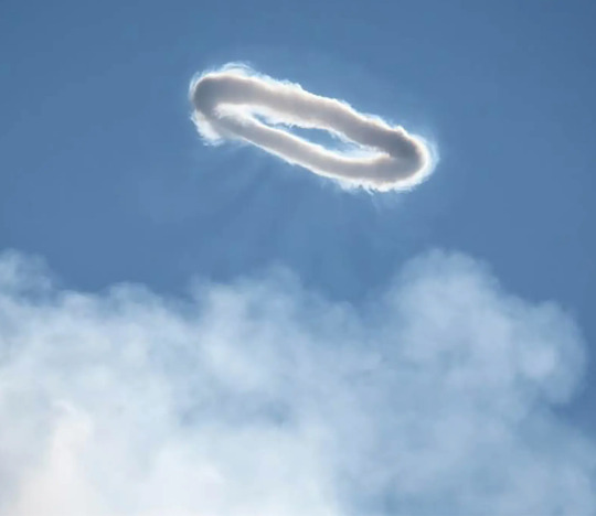
How Do Volcanic Smoke Rings Form? New Clues in the Vapor.
Some scientists think we can better understand volcanoes by learning how the gaseous vortices emerge.
Some volcanoes perform a rather subtle trick: blowing rings of vapor that waft near their craters. The short-lived rings have been observed occasionally at volcanoes like Etna in Italy and Eyjafjallajökull in Iceland. Now researchers have found new clues about how bursting gas bubbles create these curiosities in some volcanoes.
NYT: More here
119 notes
·
View notes
Note
helloooo! I just wanted to stop by and say hi! it's nice to meet you and be moots with you. I really enjoyed reading your ushijima drabble, so thanks for sharing it ^u^ I hope you'll have a lovely evening, Zevie!
HIHI new moot !! hi zebra !! you’re so kind ): your tags made me all giddy anjsjskk i was smiling like this -> 😊
i’m so happy u liked that one !!! AND I AM SO EXCITED TO READ YOUR WRITING AS WELL i literally have one of your works in my tbr / drafts rn omg.
wishing u the loveliest rest of your week ever !! THANK U FOR STOPPING BY.
2 notes
·
View notes
Text
♥ iloveuS
#love#passion#desire#embrace#i love you#lovers#romance#s#couples#vulnerable#loveinsurprisingplaces#volcano#volcanic#🌋 volcanologist#volcanology#vulcanologist#fire of love#trust#intimacy#mercy#grace#lavaflow#lava#iceland#danger#forceofnature#masculine feminine#spirituality#spiritual#nature
11 notes
·
View notes
Text
Iceland experiences another 800 earthquakes overnight as researchers find signs volcanic eruption is near. 🌋🇮🇸

3 notes
·
View notes
Text
if u need me i will in fact be listening to volcano for the next 12 or so hours bye
#i think this is my fav song from him lyrically#just gonna take the words and lock then in a special place in my heart#boba talks 💬#jisungie#volcano 🌋
4 notes
·
View notes
Text

Allison ⏳ 21277 With much discipline comes an easier life .. 💫💚 https://ift.tt/RtTzayX
#jttlpgroup#quotes#words of wisdom#life quotes#quoteoftheday#positive thinking#positive#positive thoughts#positive quotes#thinking smart#Allison ⏳#Green 💚#Nature 🌴💐#Trees 🌳#Volcano 🌋
0 notes
Text

Photographed on July 11, 2023—the Fagradalsfjall Volcano's gas cloud stretches over the Litli-Hrútur mountain and is illuminated at sunset. Smoke from nearby lava-ignited moss fires blow into the valley below. Photograph By Mike Mezeul II Photography
Iceland 🇮🇸 Has Entered A New Volcanic Era
The country’s volcanic peninsula has been dormant for centuries. But experts say the tectonic shifts behind the recent eruptions and earthquakes are a long time coming.
By Robin George Andrews | July 24, 2023
For centuries, the country’s western volcanic peninsula has been dormant, but a new era of volcanic activity could be on the horizon.
The Fagradalsfjall Volcano, a raised crater of bubbling lava—glowing bright yellow in an expanse of dark gray—is the latest eruption heralding Iceland’s new period of volcanic activity.
The eruption announced its approach on July 4 of this year, when southwest Iceland was rocked by more than 2,000 earthquakes in just 24 hours. Not long after, seismic activity dropped off as magma rose to shallow depths and ultimately gave way to oozing molten rock on July 10.
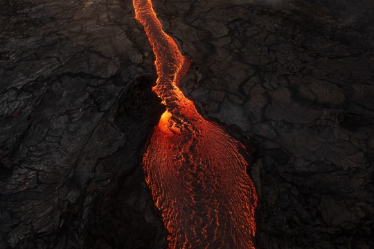
A river of lava cuts its way through the valley in between the Keilir and Litli-Hrútur mountains on the Reykjanes Peninsula. Photograph By Mike Mezeul II Photography
Located next to the small mountain of Litli-Hrútur, this eruption is taking place on Reykjanes, a volcanically active peninsula that has become a popular destination among tourists looking to see lava fountaining above and pouring onto the surface. However, the site of the new eruption is potentially hazardous—new fissures may open nearby without warning, rivers of lava can form at a quick pace, and toxic gas can quickly fill the air, according to the Iceland Met Office.
This eruption is the peninsula’s third volcanic paroxysm in a row, following on from similar lava-spewing eruptions in 2021 and 2022—and it’s unlikely to be the last.
After an eruption last summer, Dave McGarvie, a volcanologist at Lancaster University, told National Geographic that the recent uptick in volcanic activity, “... could herald the start of decades of occasional eruptions.”

A lava flow smolders, glowing red through black volcanic rock. While the Icelandic government has warned that this latest eruption is hazardous to visitors, the region is a popular destination for volcanic tourism. Photograph By Chris Burkard, Verb Photo
Iceland’s Volcanic Geology
The Reykjanes Peninsula lies about 17 miles southwest of Iceland’s capital city Reykjavik. It sits atop the continually spreading Mid-Atlantic Ridge, where the North American plate to the west and the Eurasian plate to the east are gradually pulling apart. Superhot, gassy magma, which is less dense than the surrounding rock, can sometimes rise into the shallow crust from buoyancy alone, but all that regional stretching also creates cracks where molten rock can infiltrate.
The peninsula’s subterranean bedlam seems to manifest as periodic busts of volcanism. Historical accounts and studies of ancient volcanic rocks show that times of volcanic repose transition into loud seismic and eruptive awakenings in a cycle that’s transpired several times in the past few millennia.
Although the region had been volcanically dormant for centuries, the tectonic sundering happening in the depths meant that the latest eruptions have long been in the works.
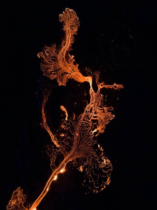
An aerial view shows the new volcanic eruption at Litli Hrútur. Geological changes normally take thousands of years, but here at the volcano, where new land is forming, the earth changes rapidly as fissures open up, and molten lava spills across the landscape. Photograph By Karim Iliya, Verb Photo
A Fiery New Beginning
And in recent years, several sheets of magma ascended toward the surface, indicated by the changing shape of the ground and swarms of earthquakes, says Tobias Dürig, a volcanologist at the University of Iceland. But for some time, these magmatic serpents failed to see sunlight—their escape was stymied either from the loss of their own upward momentum or because the resilient crust didn’t offer an escape hatch.
Nevertheless, as earthquakes began to crescendo in both frequency and strength from late 2019 onwards, scientists suspected that an eruption sometime in the future seemed inevitable. That was confirmed in dramatic fashion on March 19, 2021, when lava began gushing from a 1,650-foot-long fissure in a valley of the Geldingadalur region.
These ferocious fires are gifting scientists with an unparalleled look at the connective tissue between the igneous abyss below and the lava-licked landscape above. Their efforts help improve our understanding of Earth’s viscera, of Iceland’s volcanic cadence, and of this peninsula’s volcanic dangers.

An aerial view of the main cinder cone that has formed from the 2023 Fagradalsfjall Volcano eruption in Iceland. Photograph By Mike Mezeul II Photography
Iceland 🇮🇸 Eruption May Be the Start of Decades of Volcanic Activity
A second outburst of lava in under a year strongly suggests that the country’s Reykjanes Peninsula will become one of the most volcanically dynamic parts of the planet for several generations. (Some More Photographs August 2022)
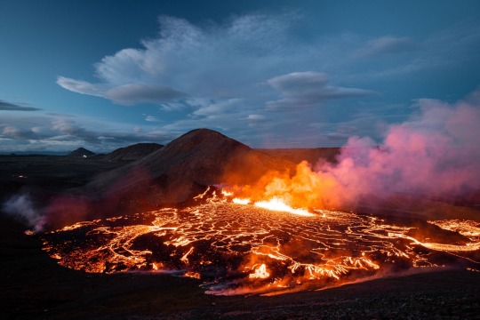
After centuries of quiescence, Iceland's Reykjanes Peninsula has erupted twice in less than a year, sending up fountains of incandescent rock. The latest eruption, which started at 1:18 p.m. local time on August 3, 2022, opened up at a fissure only a few hundred feet away from the cone crafted by last year’s volcanic outburst.

The incandescent rock is erupting with greater vigor than last year's outburst, but what the volcano will do in the days ahead—including how long this eruption will last—remains unknown. A small plane at the bottom of this image illustrates the scale of the new eruption. (August 2022)
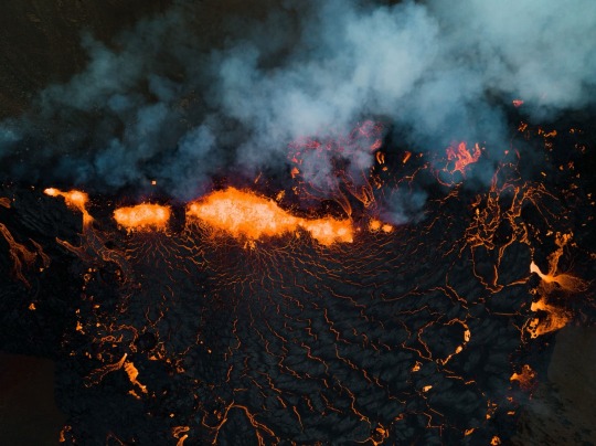
While the volcano currently poses little risk, authorities are keeping a close watch on the changing hazards. In the image below, members of the Icelandic Association for Search and Rescue are seen investigating the dangers near the lava's edge. (August 2022)
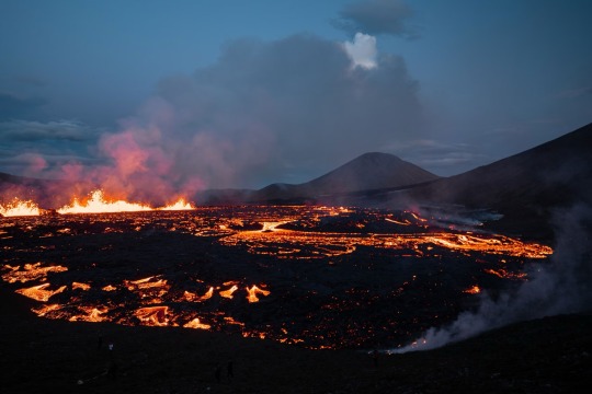
The sputtering lava has already begun building small mounds of spatter near the fissure and filling the valley with a pool of molten rock. It’s unclear for now if the lava will remain confined to these valleys or will travel further afield, perhaps reaching the sea. But for now, says Evgenia Ilyinskaya, a volcanologist at the University of Leeds, the eruption is providing scientists with “a fantastic natural experiment.” (August 2022)
#Volcanoes 🌋#Iceland 🇮🇸#Volcanic Peninsula#Volcanic Activity#Fagradalsfjall Volcano 🌋#Eruptions#Earthquakes#Potentially Hazardous#Fissures#Dave McGarvie#Lancaster University#The National Geographic#Litli-Hrútur#Reykjanes#Iceland 🇮🇸 Met Office#Geological Changes#Earth’s Viscera
0 notes
Text
instagram
0 notes
Text

Lucas ♨️ 6335 http://www.steveb29.com/2024/09/lucas-6335.html
0 notes
Note
*although it's far away, phanty will hear a muffled yell from somewhere upstairs that's soon followed by frantic and heavy footsteps!! the noise doesn't stop until it reaches the same room that phanty's in, and if he were to turn towards it he'll see that the one responsible is one incredibly pissed off mondo who chucks the prop skeleton head right at him!!*
"Bastard!! Can't even let a guy sleep without pullin' some shit!" *then he lunges at him, screaming all the while!!*
"Doh! There it is-!" The smile on Phanty's face instantly widens the moment he heard that muffled scream, cackling loudly! He immediately knew who it belonged to, of course. He doesn't even try to hide or escape when he hears Mondo coming, and in fact, still gives him that beaming smile when he flies the door open with that enraged expression on his face! The prop skeleton head smacks Phanty in the chest, and aside from the small 'oof-!' He gives, only makes him laugh even harder!!
"Gahahaha!!!! Blegheheheeeee~! Aww, ya didn't like my little wake up call? I was tryyying to wake you up normally, but you slept like a log! So I thought that the next best thing, of course, was to have you wake up next to this lovely-oh!!!" Seeing him begin to lunge at him, Phanty begins crawling away while laughing even harder! Not that he's trying too hard to really escape him, he just finds it funnier to give him a little challenge! That, and he's laughing too hard to be move quickly, anyway~! "Now, nowwww, let's not be sooo violent! Did you have a-hehehe-great sleeep? Gaaahahahaaaaah!!!"

#KJFNDVJDFNJK MODOOO!!! SUPER MEGA POPPED CORN!!!!#SO MUCH SO HE'S A VOLCANO!!!! 🌋🍿💢!!!!!!!!!!!!!!!!#AND PHANGTY OF COURSE!!! IS N O T SORRYYYY!!!#GET HIM MONDO!!!!#Phanty answers;;#essenceofjustice
1 note
·
View note
Text
most of my funny ffxiv au musings are on twitter but i will port them for you
since bright volcano is winning the conjurer poll atm and he wpuld be in gridania as well...
leaked first meeting
bright volcano and shifty lock eyes at the carline canopy
shifty, looking at his chest, thinking: man i miss splendont... i miss his big buff chest... i miss burying my face in his mantiddies
bright volcano, also thinking + staring at shifty's face but not realizing that he's looking at his chest: where him face marks
(i ended with 'this might be my stupidest htf thread yet by the way')
BUT THEN I ADDED MORE
the scene where estinien is working out shirtless in post endwalker
zero: shall we disrobe as well?
shifty, looking at splendont and raising his eyebrows: i think we shou-
lifty, covering his mouth: STOP
(this scene btw)
https://youtu.be/JLD2ZYNXPHw?si=euA-zzIkDSdNTIKn
0 notes


