#tercom
Explore tagged Tumblr posts
Visit Tumblr Blog
Explore Tumblr blogs with no restrictions, modern design and the best experience.
Last Seen Tumblr Blogs


Fun Fact
After the announcement of the deal with Yahoo!, there were 170K signatures of unhappy Tumblr users petitioning to prevent the sale in 2013.
Text
0 notes
Text
Babur Missile
Babur (named after the first Mughal Emperor Zahir ud-Din Babur), also designated Hatf VII, is the first land attack cruise missile to be developed byPakistan.
Launched from ground-based transporter erector launchers, warships and submarines, the Babur can be armed with a conventional or nuclear warhead and has a reported range of 700 km (430 mi). The missile is designed to avoid radar detection and penetrate enemy air defences. Serial production of the Babur started in October 2005.
Babur is believed to have been developed in response to reports that India was planning to acquire Patriot missiles from the US, in order to set up a ballistic missile defense system to counter Pakistan's arsenal of ballistic missiles.
Design
The Babur's airframe is made up of a tubular fuselage, with a pair of folded wings attached to the middle section and the empennage at the rear along with the propulsion system. Propelled by a jet engine (either turbofan orturbojet), the Babur has a maximum speed of approximately 550 mph. On launch, a booster rocket provides additional thrust to accelerate the missile away from the launch vehicle. After the launch the wings unfold, the booster rocket is jettisoned and the jet engine started.
Guidance
The Babur's guidance system uses a combination of inertial navigation systems, terrain contour matching (TERCOM) and GPS satellite guidance. The guidance system reportedly gives the missile pinpoint accuracy. GPS access is not guaranteed under hostile conditions so the latest production models have also reportedly incorporated the Russian GLONASS. Future software and hardware updates could include the European Union'sGALILEO and China's Beidou navigation system.
Features
The missile is stated to have a high degree of maneuverability, allowing it to "hug" the terrain, and "near-stealth" capabilities. Terrain hugging ability helps the missile avoid enemy radar detection by utilizing "terrain masking", giving Babur the capability to penetrate enemy air defence systems undetected and survive until reaching the target. The missile's design features can be compared with the American BGM-109 Tomahawkcruise missile.
More advanced versions of the Babur are under development. Later versions are planned to have a range of 1000 km and be capable of being launched from Pakistan Navy submarines such as the Agosta 90BKhalid class.
Operational history
On August 12, 2005, Pakistan publicly announced that it had successfully test fired a nuclear-capable cruise missile with a range of 500 km. The missile was launched from a land based transporter erector launcher(TEL). The unannounced launch on 11 August 2005 caught much of the international community by surprise due to the technically advanced nature of the missile, as well as the fact that Pakistan did not notify India of its test-firing as the existing notification agreement is limited to ballistic missile testing only.
On March 22, 2007, Pakistan test-fired an upgraded version of the Babur with an extended range of 700 km. Pakistan carried out two more tests of Babur on July 26, 2007 and December 11, 2007.
On May 6, 2009, Pakistan conducted another test-firing but did not announce the event until 9 May 2009, citing political reasons.
On October 28, 2011. Pakistan successfully test fire its Babur Cruise missile and has a range of 700 kilometer. The ISPR said Babur was capable of carrying conventional and atomic warheads. A special feature of this launch was the validation of a new multi tube Missile Launch Vehicle (MLV) during the test. The three tube MLV enhances manifold the targeting and deployment options in the conventional and nuclear modes. With its shoot-and-scoot capability, the MLV provides a major force multiplier effect for target employment and survivability.
On June 6, 2012 Pakistan conducted a successful test-fire of the multi-tube, indigenously developed Cruise Missile Hatf-VII (Babur), which can carry both nuclear and conventional warheads with stealth capabilities. It was the third test-fire conducted by Pakistan in the recent past, of different capacity and load. “It can carry both nuclear and conventional warheads and has stealth capabilities,” said an official announcement of the ISPR. “It also incorporates the most modern cruise missile technology of Terrain Contour Matching (Tercom) and Digital Scene Matching and Area Co-relation (DSMAC), which enhances its precision and effectiveness manifolds.”
0 notes
Photo

#Str33tMusicArtistProfile : @normal412 #Normal Source: https://str33tmusicprofiles.tumblr.com/post/157309314993/artist-normal #LegendsxIcons #Tercom #UntilThenEP #followth3music #hiphop #music #diversity #Str33tMusic #artist #rapper #rap #Profiles #SMAP #힙합
#힙합#diversity#legendsxicons#rapper#music#followth3music#hiphop#tercom#str33tmusic#rap#normal#str33tmusicartistprofile#profiles#smap#artist#untilthenep
2 notes
·
View notes
Photo

HAD TO STAY UP AND FINISH THIS. Ok so I have profiles being made for artists who are up-in-coming and slightly established. I am very picky with music and I'm trying to be more opwn-minded because I can't have a biased opinion while running a blog. Just know if I have said yes to you prior to this month I like your music.👍 Anyway- #repost @str33tmusic #Str33tMusicArtistProfile : @normal412 #Normal Source: https://str33tmusicprofiles.tumblr.com/post/157309314993/artist-normal #LegendsxIcons #Tercom #UntilThenEP #followth3music #hiphop #music #diversity #Str33tMusic #artist #rapper #rap #Profiles #SMAP #힙합 (at Las Vegas, Nevada)
#untilthenep#tercom#music#힙합#repost#diversity#profiles#rapper#artist#hiphop#str33tmusic#legendsxicons#str33tmusicartistprofile#rap#smap#normal#followth3music
1 note
·
View note
Photo

Today is a great day to be creative. #terxcom #terriblycommitted #TerCom #pittsburgh #local #apparel #paint #localbrand #apparel (at East End, Pittsburgh, Pennsylvania)
0 notes
Quote
下ではセクハラ・パワハラが横行し上は極右思想の温床になっている、日本の体育会系の悪いところを煮詰めたような組織
[B! 自衛隊] JGSDF TERCOM(陸上自衛隊 教育訓練研究本部) on Twitter: "8月23日(火)、 #TV 番組でお馴染みの #作家 #竹田恒泰 氏をお招きし #幹部高級課程 学生に対し「日本はなぜ世界で一番人気があるのか~自衛隊バージョン~」と題した #講話 をいただきました。 #学生 にとって興味深い内容… https://t.co/VCdaQi1QWn"
2 notes
·
View notes
Text
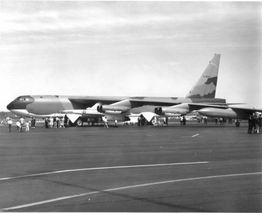
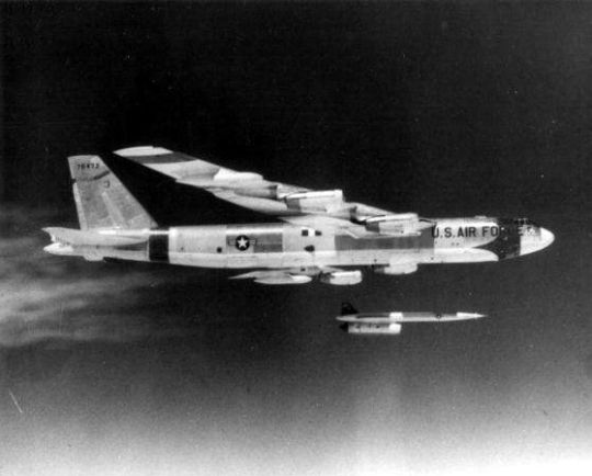
-A B-52E armed with two Hound Dog missiles at an airshow/open-house, sometime in the 60's. | Photo: AF GlobalStrike
FLIGHTLINE: 111 - AGM-28 HOUND DOG
The Hound Dog cruise missile was carried by B-52 bombers from 1960 to 1977, and (fortunately) was never fired in anger.
Developed in response to USAF General Operational Requirement 148, issued in 1956, the Hound Dog cruise missile (variously designated B-77, GAM-77 and finally AGM-28) was produced by North American Aviation (Later Rockwell International, now a part of Boeing) from 1959 to 1963 and was carried by B-52s from 1960 to 1977.
-Orthograph of the Hound Dog missile. | Illustration: North American Aviation
STAND-OFF WEAPONS, OR: HOW I LEARNED TO STOP WORRYING AND LOVE THE BOMB
During the 1950s, the US became aware of rapid developments by the Soviet Union in surface to air missile (SAM) technology. SAM sites soon began to proliferate around Moscow and other key sites, threatening SAC's B-36, B-47 and B-52 bombers. As the SAMs were located at fixed sites, easily discernable from aerial recon or satellite photos, the USAF determined that the best counter would be to develop "stand-off" weapon that could be fired from the approaching bombers and destroy the SAM site before they could threaten the attack force.
GOR-148 therefore called for a supersonic missile, to be carried in pairs by a B-52 Stratofortres, capable of flying to a predetermined target outside the SAM's range and to destroy the target with a nuclear bomb, allowing the bombers to then attack their main targets with impunity. In July of 1957, Chance Vought and North American submitted proposals, both based on existing weapons. Chance Vought's design was based on the SSM-N-9 Regulus II SLCM, while the NAA proposal was adapted from the SM-64 Navaho cruise missile. One month later, NAA received a contract to develop their design, which had been christened the GAM-77.
YOU AIN'T NOTHIN' BUT A HOUND DOG...
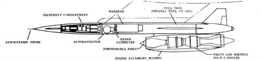
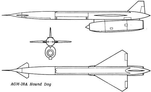
-Cutaway drawing of the GAM-77, later redesignated the AGM-28A. | Illustration: North American Aviation.
The GAM-77 was nicknamed the Hound Dog, a reference to a song made popular by Elvis at the time of development. The missile featured a canard and delta wing, with single vertical fin and rudder. It was powered by a version of the J52 turbojet, which also was used in the A-4 Skyhawk, A-6 Intruder and EA-6 Prowler, and, in its civilian form as the JT8D, propelled the Boeing 727 and 737-100/200, as well as the DC-9 and MD-80. Unlike with the other planes, the Hound Dog's engine was run at 100% output for its entire flight, resulting in an operational lifespan of only 6 hours (not an impediment to a missile expected to be destroyed by its own nuclear bomb well before reaching that run time, mind you). The Hound Dog’s fuel tank could be topped off from the B-52's own fuel supply, allowing the larger plane to use both missiles' engines to assist on take-off. Hound Dogs were guided by an inertial navigation system, which was updated by a star tracker mounted in the pylon. The B-52 would launch its missiles from an altitude of 5,000' or more, and from there the GAM-77 could fly at high (+5,000 feet) or low altitude (under 5,000 feet), though at the cost of decreased range; early models were not capable of terrain following/terrain avoidance, and thus no obstructions could be present along the flight path. A dogleg could also be added to flightpath to draw off interceptors. Later models of the GAM-77 added a radar altimeter, allowing flight down to 100 feet. This would allow the missile to hide in the radar clutter of low altitude. The Dog had a CEP of 2 miles, though with its W28 warhead, which had yields ranging from 70kt to 1.45mt, would effectively destroy its target even with a near-miss.
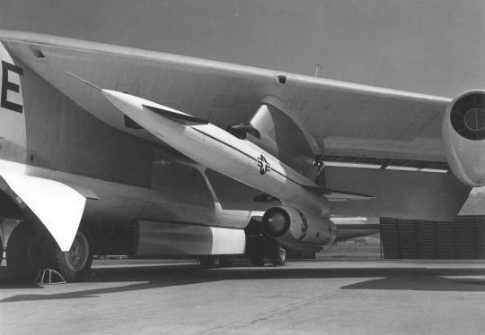
-A Hound Dog missile under the wing of a B-52. | Photo: USAF
TESTING, TESTING...
The first drop test of a dummy GAM-77 occurred in November 1958, and between April 1959 and August 1965 fifty-two missile tests were conducted at Cape Canaveral AFS, Eglin AFB and the White Sands Missile Range. Even before the drop test, the USAF had awarded NAA a production contract, with deliveries beginning on 21 December 1959. Late in 1961, production switched to the upgraded GAM-77A model, which included a upgraded INS with integrated star tracker and radar altimeter. The A model also had increased fuel capacity, and incorporated radar-absorbing materials into the nose cone, engine inlet spike and the intake duct to further reduce its already low radar cross-section.
-A Hound Dog separates from its B-52G launch aircraft during a test shot some time in the 1960s. | Photo: AF GlobalStrike
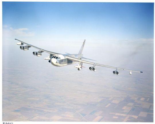
-Color photo of another B-52G carrying two GAM-77s. | Photo: AF GlobalStrike
A SHORT BUT UNEVENTFUL SERVICE...
Under the 1962 Tri-Service system, the GAM-77 was redesignated the AGM-28A, while the GAM-77A became the AGM-28B. In 1971, one Hound Dog was fitted with a prototype terrain contour matching (TERCOM) system. Had the USAF chosen to proceed with development of this version, it would have been designated the AGM-28C, but instead the technology continued in development until the AGM-86 ALCM was accepted for service in 1982. In 1972 Bendix was awarded a contract to develop a passive radar-seeker for the Hound Dog, which would have turned it into a long-range anti-radiation missile. At least one test flight occurred in 1973, but the type was not approved for conversion/production, and the last AGM-28B was retired from alert status on 30 July 1975.

-SAC crews scramble to man B-52s equipped with Hound Dogs. Despite (or perhaps because of) exercises like this, no Hound Dog was ever fired in anger. | Photo: USAF
SENT OFF TO A FARM...
Even after retirement, approximately 300 Hound Dogs were retained in storage between 1975 and 1977, but by 1978 they had mostly been scrapped. A large number of missiles, stripped and demilled, have been preserved in museums and air parks across the country.
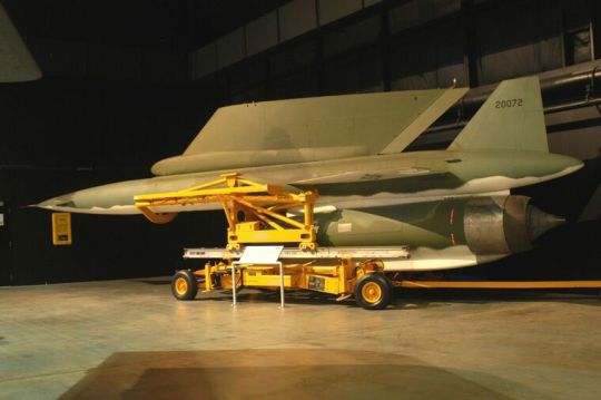
-An AGM-28, along with its mounting pylon, on display at the National Museum of the USAF in Dayton. | Photo: USAF Museum

-Another Hound Dog on display in its earlier all-white paint scheme. The black cylinder is a simulated nuclear warhead, while the silver object to the right is the INS. | Photo: Cliff
#aircraft#aviation#avgeek#cold war#airplanes#cold war history#airplane#usaf#coldwar#aviation history#b52#boeing b 52 stratofortress#buff#hound dog#gam77#agm128
61 notes
·
View notes
Text

JSM missile
Long-distance Anti-ship Missile
The Joint Strike Missile – or JSM – is a long-distance anti-ship missile designed to take on high value, heavily defended targets. The long standoff range (distance from the aircraft to the target) ensures that the aircraft and pilots remain out of harm’s way.
JSM has sophisticated target acquisition capability that uses Autonomous Target Recognition, made possible by an imaging infrared seeker. It is the only fifth-generation cruise missile that will be integrated on the F-35 and also available for integration on other aircraft intended for offensive anti-surface warfare (OASuW) applications.
FEATURES
Advanced engagement planning system that exploits the geography in the area
Accurate navigation system for flight close to terrain
High maneuverability to allow flight planning in close vicinity to land masses
Discriminating seeker with imaging infrared technology
Two-way networking datalink (compliant with standard military equipment) offering target-update, retargeting and mission-abort capabilities
The Joint Strike Missile is a partnership between Raytheon Company and Norwegian defense company Kongsberg Gruppen. Source raytheon.com
JSM Key Characteristics
Length : 4.00 m (157 in)
Height : 0.52 m (20.4 in)
Width : 0.48 m (18.9 in) (stowed)
Mass : 416kg (917 lbs)
Speed : High Subsonic
Agility : High
Guidance
Inertial Navigation, aided by GPS and
TERCOM.
Imaging Infra-Red Target Seeker.
Source kongsberg.com
11 notes
·
View notes
Photo

Avenger Drone for geographical mapping, such as DSMAC and TERCOM. And for greater detailed mapping of elevations. (*Lockheed Martin’s “Legion Pod”)


“We must face our weaknesses of Financial Security and Disease and address the issue of proper Facilitation and Rehabilitation.”
0 notes
Link
0 notes
Text
Санкции вещь не всегда вредная: ученый Андрей Терехов рассказал о перспективах экономики России
Санкции вещь не всегда вредная: ученый Андрей Терехов рассказал о перспективах экономики России
pixabay.com Экономические санкции могут послужить отличным мотиватором для движения вперед с учетом нашего менталитета. Такое мнение в беседе с корреспондентом ФАН высказал доктор физико-математических наук, гендиректор IT-компании Lanit-Tercom Андрей Терехов. С 24 февраля экономическое давление на Россию усилилось многократно. Так, по состоянию на 22 апреля 2022 года общее количество введенных…

View On WordPress
0 notes
Text
Digital Elevation Model Market,Revenue Poised for Significant Growth During the Forecast Period of 2020-2027
The Global Digital Elevation Model Market Report added by Reports and Data provides diligently analyzed data pertaining to the global Digital Elevation Model market including its market dynamics, industry environment, and leading segments of the market. The report provides an extensive analysis of the market growth and influential factors including latest technological advancements and product developments. The report presents a thorough analysis of the Digital Elevation Model market covering key trends, challenges, opportunities, market players’ profiles, and industrial chain analysis.
The latest report is furnished with a comprehensive impact analysis of the current COVID-19 pandemic on the market. The rapidly changing dynamics of the market and current and future growth potential of the market are covered in the report. The report offers crucial information about the initial and future assessment of the impact of the COVID-19 crisis on the overall market.
Get a Free Sample PDF Report to understand our report before you purchase @ https://www.reportsanddata.com/sample-enquiry-form/2807
Key companies operating in the industry and profiled in the report include:
TomTom International N.V.
Harris MapMart
LAND INFO Worldwide Mapping, LLC
CompassData Inc.
DHI GRAS A/S
Telespazio SPA
Apollo Mapping
CATUAV
VRICON
PASCO Corporation
NIRAS A/S
The report covers an exhaustive analysis of manufacturing processes, development policies, plans, product portfolio, and cost analysis. The data is represented in the form of tables, charts, graphs, diagrams, and figures and other pictorial representations. Moreover, the report also includes macroeconomic factors and regulatory policies pertaining to the Digital Elevation Model industry for evaluation and predictive analysis.
The report analyzes various product types and applications along with manufacturing and process analysis and cost analysis. The data is further validated via extensive primary and secondary research verified by industry experts and professionals of the profiled companies.
By Type (Revenue, USD Million; Volume in Tons, 2017–2027)
Raster (Heightmap when representing elevation)
Triangular Irregular Network (TIN)
Photogrammetry
Lidar
IFSAR
By Application Type (Revenue, USD Million; Volume in Tons, 2017–2027)
Engineering and infrastructure designing
Precision farming and forestry
Modelling water flow for hydrology and mass movement
Examining terrain conditions for geomorphology
Military Applications and flight simulations
Assisting in 3D planning and TERCOM
· Others
Grab Your Report at an Impressive Discount! Please Click Here @ https://www.reportsanddata.com/discount-enquiry-form/2807
Furthermore, the report includes an in-depth analysis of the competitive landscape. The segment covers comprehensive overview of the company profiles along with the product profiles, production capacities, products/services, pricing analysis, profit margins, and manufacturing process developments. The report provides insightful information about recent mergers and acquisitions, product launches, collaborations, joint ventures, partnerships, agreements, and government deals. It also covers a SWOT Analysis and Porter’s Five Forces Analysis to provide a better understanding of each market player.
GET THE ENTIRE MARKET INTELLIGENCE REPORT AT @ https://www.reportsanddata.com/report-detail/digital-elevation-model-market
Based on region, the Digital Elevation Model industry is segmented into North America, Latin America, Europe, Asia Pacific, and Middle East & Africa. Additionally, the report provides beneficial data about distribution, production, consumption patterns, export/import, and demand and supply ratio. The report also offers the strategic business steps taken by key market players in each region.
Regional Analysis Covers:
North America (U.S., Canada, Mexico)
Europe (U.K., Italy, Germany, France, Rest of EU)
Asia Pacific (India, Japan, China, South Korea, Australia, Rest of APAC)
Latin America (Chile, Brazil, Argentina, Rest of Latin America)
Middle East & Africa (Saudi Arabia, U.A.E., South Africa, Rest of MEA)
Highlights of the TOC of the Digital Elevation Model Market Report:
Global Digital Elevation Model Market Overview
Global Digital Elevation Model Market Size and Share by Types
Global Digital Elevation Model Market Size and Share by Applications
Global Digital Elevation Model Market Sales and Growth Rate
Global Digital Elevation Model Market Competitive Landscape
Global Digital Elevation Model Market Regional Analysis
Global Digital Elevation Model Market Forecast Estimation (2020-2027)
Global Digital Elevation Model Market Trends, Drivers, Challenges, Risks, and Opportunities
Global Digital Elevation Model Market Revenue, Price, and Gross Margin for Each Segment
Global Digital Elevation Model Market Industrial Chain Analysis
Read more about the TOC in the full report.
Request customization of the report @https://www.reportsanddata.com/request-customization-form/2807
Thank you for reading our report. Customization of this report is available in chapter-wise or region-wise sections. Kindly get in touch with us to know more about the report and our team will provide excellent assistance.
0 notes
Photo

Hope everyone enjoys their Saturday! Just a reminder to stay #TerCom & make moves towards your goals this weekend!#TerriblyCommitted #terxcom #TerCom #NMTD (at Pittsburgh, Pennsylvania)
0 notes
Quote
自衛隊は最高裁判所が認定した差別主義者(https://www.bengo4.com/c_23/n_14401/)を呼んでレイシストを養成するのか。
[B! 自衛隊] JGSDF TERCOM(陸上自衛隊 教育訓練研究本部) on Twitter: "8月23日(火)、 #TV 番組でお馴染みの #作家 #竹田恒泰 氏をお招きし #幹部高級課程 学生に対し「日本はなぜ世界で一番人気があるのか~自衛隊バージョン~」と題した #講話 をいただきました。 #学生 にとって興味深い内容… https://t.co/VCdaQi1QWn"
1 note
·
View note
Photo

The deserts of Rajasthan, Gujarat and the Arabian sea barely offers and distinct features for the TERCOM system to work properly. Read about why US had to send Tomahawks to its intended targets over Iran during the Gulf War. pic.twitter.com/DQI1t00qvo
— Aniruddha (@MI6GB) February 11, 2021
0 notes
Text
Digital Elevation Model Market Top Trends, Size, Share, Future Growth Opportunities & Forecast by 2027
This analysis of the Global Digital Elevation Model Market aims to offer relevant and well-researched insights into the contemporary market scenario and the emergent growth dynamics. The report on Digital Elevation Model Market also gives the market players and fresh contenders a holistic view of the global market landscape. The comprehensive study will help both established and emerging players formulate lucrative business strategies and realize their short-term and long-term goals. The Digital Elevation Model industry has witnessed a stable growth rate in the past decade and is expected to continue on the same path in the forthcoming decades. Therefore, it is crucial to recognize all investment opportunities, potential market threats, restraining factors, challenges, market dynamics, and technological development to intensify footholds in the Digital Elevation Model sector. This report has evaluated all the above mentioned aspects to present a detailed assessment to the reader to assist them in achieving the desired growth in their businesses.
This report covers the recent COVID-19 incidence and its impact on Digital Elevation Model Market. The pandemic has widely affected the economic scenario. This study assesses the current landscape of the ever-evolving business sector and the present and future effects of COVID-19 on the market.
Get a sample of the report @ https://www.reportsanddata.com/sample-enquiry-form/2807
Digital Elevation Model: Market Participants
TomTom International N.V.
Harris MapMart
LAND INFO Worldwide Mapping, LLC
CompassData Inc.
DHI GRAS A/S
Telespazio SPA
Apollo Mapping
CATUAV
VRICON
PASCO Corporation
NIRAS A/S
The forecast estimation states the global Digital Elevation Model market is expected to dominate the economic sphere of the world with significant growth in the coming years. The growth is boosted by a change in demand patterns, rapidly developing infrastructure, technological advancements, and product advancements. The current and emerging trends are expected to shape up the industry and help in gaining a strong foothold in the global market to contribute to the revenue generation.
The Global Digital Elevation Model market is further analyzed on the basis of key companies operating in the business sphere and major geographical regions where the market has a substantial size and growth rate.
By Type (Revenue, USD Million; Volume in Tons, 2017–2027)
Raster (Heightmap when representing elevation)
Triangular Irregular Network (TIN)
Photogrammetry
Lidar
IFSAR
To read more about the report @ https://www.reportsanddata.com/report-detail/digital-elevation-model-market
By Application Type (Revenue, USD Million; Volume in Tons, 2017–2027)
Engineering and infrastructure designing
Precision farming and forestry
Modelling water flow for hydrology and mass movement
Examining terrain conditions for geomorphology
Military Applications and flight simulations
Assisting in 3D planning and TERCOM
Zonal Partition of the Market: North America, Latin America, Europe, Asia-Pacific, and the Middle East & Africa.
The report covers extensive analysis of market segments that are anticipated to lead by the end of the forecast period (2020-2027). The report puts a special emphasis on the upstream raw materials, downstream buyers, industrial chain analysis, technological and product advancements, and production and manufacturing capacities of the Digital Elevation Model market. Moreover, the report provides an in-depth analysis of the core segments of the market by analysis of the applications, types, consumption patterns, market drivers and restraints, and challenges to be faced in the market.
The research study focuses on the emerging development patterns and manufacturing processes anticipated to boost the growth of the market. It also includes extensive profiles of prominent contenders of the industry and provides a complete analysis inclusive of their market share, market size, production capacity, sales and distribution network, import/export activity, and product portfolios.
Major objectives of the Global Digital Elevation Model Report:
· Analysis and forecast estimation of the Global Digital Elevation Model Market based on the market segmentation into types, applications, and regions
· Analysis of micro and macroeconomic factors affecting the global Digital Elevation Model market
· Valuable insight into the major drivers, limitations, opportunities, and challenges faced by the global Digital Elevation Model market and its players
· In-depth analysis of the prominent contenders along with their business strategies and expansion plans
· Strategic recommendations to the established companies as well as new entrants to assist in the formulation of investment plans
· Comprehensive analysis of the competitive landscape of the Digital Elevation Model industry
To summarize, the report provides a better understanding to the reader about the Digital Elevation Model industry by offering a detailed explanation of the competitive landscape, industry environment, market projections, growth driving and restraining factors, limitations, entry barriers, and opportunities. The report also covers the regulatory framework, investment opportunities, and other growth driving factors. The report allows the reader to gather insightful information about each segment of the market and provides a historical, present, and prospective outlook of the market.
Thank you for reading our report. To know more about the report or for any queries regarding customization, please connect with us. Our team will provide excellent assistance and make sure the report is tailored to meet your requirements.
Ask for Discount @ https://www.reportsanddata.com/discount-enquiry-form/2807
Contact Us
John W
Head of Business Development
40 Wall St. 28th floor New York City
NY 10005 United States
Direct Line: +1-212-710-1370
0 notes