#peninsula ridge
Explore tagged Tumblr posts
Visit Tumblr Blog
Explore Tumblr blogs with no restrictions, modern design and the best experience.
Last Seen Tumblr Blogs


Fun Fact
Premium Tumblr themes are available from anywhere between $9 to $49.
Text


anyone else have dark memories of driving down this road as a child
#main ridge you will always be famous#this is barkers for the losers who can’t identify mornington peninsula roads on sight#australian gothic#isabelle says things#australia#mornington peninsula
50 notes
·
View notes
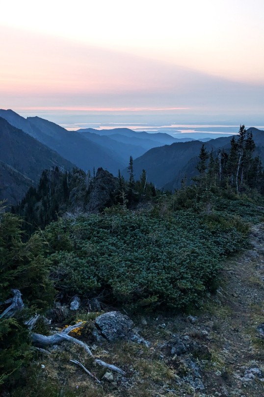
Text

3/21/2025
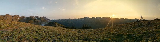
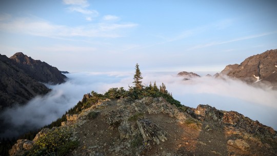
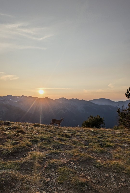
#pnw#my post#pnw photography#pnw vibes#pnw aesthetic#pnw gothic#pacific northwest#washington#olympic peninsula#hike#hiking#trail#wooden bridge#mountains#mountain hike#lake angeles#lake angeles trail#hurricane ridge#switchback trail
22 notes
·
View notes
Text
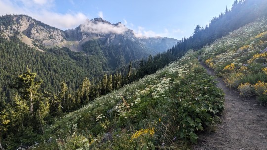
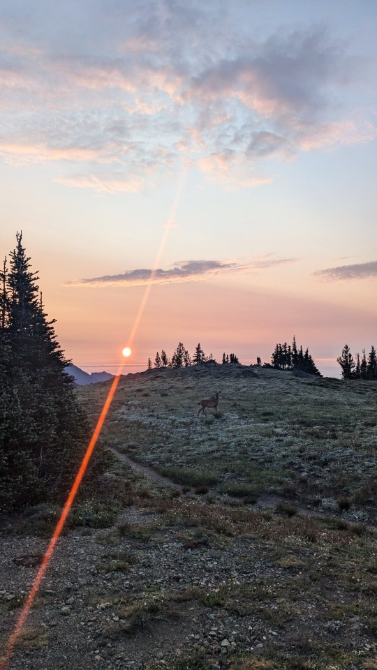
Various scenes from Boulder Ridge/Marmot Pass
#marmot pass#boulder ridge#buckhorn wilderness#olympic peninsula#outdoor photography#nature photography#original photography#pnw
3 notes
·
View notes
Text
Residential Plumbing Services In Main Ridge
At Refresh Plumbing & Gas, we pride ourselves on providing top-notch residential plumbing services in Main Ridge. Whether you need routine maintenance, urgent repairs, or expert installation, our team of experienced Main Ridge plumbers is here to assist you. We understand that plumbing issues can arise at any time, which is why our emergency residential plumbers are available around the clock to…
#Plumber In Mornington Peninsula#Plumbing In Mornington Peninsula#Residential Plumbing In Main Ridge#Residential Plumbing Main Ridge#Residential Plumbing Mornington Peninsula#Residential Plumbing Services#Residential Plumbing Services In Main Ridge
0 notes
Text
"RESIST PROJECT 2025" Stencil - BTS
I figured I'd share a behind-the-scenes look at how I made my stencil. Feel free to use what you find in this post (and my other posts) to make your own! Just be safe, as it requires sharp blades and chemical fumes.
I started by making the following graphic:

I did my usual thing of putting the graphic onto my phone, tracing it from my phone onto clear plastic with permanent marker, then projecting the shadow onto... well, usually I'd say "foam board" here, but this time it was card stock.


I first refined the pencil trace.

I then used a strip of cereal box I cut to help me consistently add bridges to the trace so no "islands" of the stencil would be completely cut off, and to "peninsulas" so they can remain ridged. I learned from looking at other stencil fonts online that following existing edges helps to keep the final product legible, but there also needs to be a balance with making the cut stencil sturdy enough to last. Most of the bridges I made were as short as possible.

I put this card stock onto a disposable hard surface so I could cut it using my box cutter. I also bought an Exacto-Knife but the blade was shit. Cutting with a box cutter is both painful and time consuming, but this ended up being the most effective tool I had available. I did end up with a blister, though.
Anyway, here's what I ended up with:

The above image was used in my second stencil post.
I ended up making a border of duct tape for my master stencil to protect its edges and to provide a surface for tape to cling to that wouldn't break down overtime.
The idea of a "master" stencil is to have a form I can quickly trace for when I want to make a new stencil. Getting paper wet will damage and warp it over time, so keeping a pristine master stencil is valuable since the copies are disposable and making one from scratch takes a lot longer.
=================================
Okay, so from here, I needed to make a stencil copy using my newly created master stencil.


After tracing and cutting the copy, I took it out in a well ventilated area to spray paint the decal onto some foam board.


A stencil copy like this one can be used multiple times, but it's recommended that you let it dry a little before uses or it will get too wet and warp quickly, ruining it sooner than later.
This was my first test with my first stencil copy:

The above image was used for my forth stencil post.
It's important to make sure the stencil is flat against the surface you're applying the decal to in order to prevent fuzzy edges. I didn't do that and you can see that the letters are not sharp in some spots.
Lastly, I did my little test where I put my sign in a distant room with all lights off except in that room, then took a photo to see how it looked:

There are tricks online about how to flatten a warped piece of paper that I'd recommend looking into, since stencils generally don't last long and will warp pretty quickly. As for how to properly secure a stencil to a vertical surface, well... I won't go there :)
Here are the original posts:
#trump#donald trump#maga#fuck maga#trump administration#elon musk#elon#musk#art#artwork#protest#america#fuck trump#fuck donald trump#fuck elon#fuck elon musk#artists of tumblr#traditional art#usa#philosophy#debate#morality#resistance#us politics#elongated muskrat#behind the scenes#diy#diy projects#diy craft#stencil
44 notes
·
View notes
Text
Sidenote though, with "Pre-Unification Terra", I enjoy the location names getting twisted into silly nonsense as yes, over literally millenia, if anything of our languages survives, the etymology of names is bound to be lost and they are bound to get distorted in a History spanning game of telephone.
What I find FUNNY is that of all places, germany remains a nation state.
Things like the US are obvious; it's big enough to remain as a cultural realm for millenia, even if the specific nation states that occupy it change.
Britain I get, because then you can have that fun thing that a former island nation occupies a swath of desert.
France, yeah, that's silly, but it makes sense, if only for the satire. Their continued existence, in ANY century, is a punchline all by itself.
But "jermani" just doesn't make any sense whatsoever even by the internal logic. Especially since no other countries like that were added - we don't get a random Thy-land or Wenezuel or anything. It's like, sure, you can come along too, I guess. I like to think it doesn't have anything to do with a sort of fascism wank, to ensure some players get to paint up their miniature dolls as literal space nazis. The most vanilla explanation I guess would be that Warhammer has a big german fanbase and they didn't want to alienate them. Also pausible but slightly disappointing would be that they just couldn't culturally justify their "knights in space armor" setting without the germanic element. Related to that, the idea that this is the minimum level of detail for a depiction of Europe even tens of thousands of years in the future. Logically there is no reason it should have more political geography than the Kamchatka Peninsula (or in that era I suppose the Kamchatka Ridge), but for war-gaming purposes I guess it's hard to get away from at least a minimalistic WWI/WWII configuration for a mostly western audience.
60 notes
·
View notes
Text

Uplift Underway in Finland’s Kvarken Archipelago
Some 20,000 years ago, during the Last Glacial Maximum, the Baltic Sea sat under a sheet of ice as thick as 3,000 meters (10,000 feet). Scientists estimate that the weight of that ice pressed the land down more than 500 meters (1,600 feet).
Since the glaciers receded and the weight was lifted, the land has been bouncing back. The rates of uplift, known as glacial isostatic adjustment or isostatic rebound, in this region are among the highest on Earth. By one estimate, 700 hectares of new land—about twice the size of Central Park in New York City—rise from the sea each year along the coast of the Gulf of Bothnia, the Baltic Sea’s northern arm.
This uplift is especially apparent in the Kvarken Archipelago of Finland. The area, seen in this image acquired by the OLI (Operational Land Imager) on Landsat 8, is an agglomeration of islands that is constantly changing as the land rises. Its approximately 5,600 islands and 2,400 kilometers (1,500 miles) of shoreline form labyrinthine waterways that present hazards to ships but exploration opportunities for canoers and kayakers. The Kvarken Archipelago, along with the High Coast region across the gulf in Sweden, is designated as a UNESCO World Heritage site.

The terrain emerging from the sea has revealed remarkable glacial formations. On and around the island of Björkö, shown in this detailed view, unique features known as De Geer moraines have surfaced thanks to isostatic rebound. These washboard-like ridges form when water running beneath the ice deposits boulders, stones, and finer material at the ice edge. When the ice retreats or a large block breaks away, another moraine begins to form at the new edge.
De Geer moraines typically measure 1 to 2 kilometers long and 2 to 5 meters high, spaced 50 to 200 meters apart. Scientists think their presence and spacing are related to the speed of ice-margin retreat, the water depth in which they were formed, and the terrain beneath the ice. LiDAR-based digital elevation models have recently revealed the existence of more De Geer moraines in southern and western Finland than previously realized.

The constant emergence of new land after the ice’s disappearance affected how people ultimately developed the area. For example, the land on which the town of Vaasa was founded was a forested island in the early 14th century. The island later merged with the mainland, and Vaasa grew throughout the 17th and 18th centuries as a thriving harbor and trading point. Still, the land continued to rise, causing the coastline to migrate farther and farther from the town. In August 1852, a napping peddler’s pipe ignited a fire that destroyed much of the settlement. Officials took the opportunity to reestablish Vaasa about 6 kilometers (4 miles) to the west to make it a coastal city once again. Remnants of the original town are preserved in “Old Vaasa” (or Vanha-Vaasa).
The islands, peninsulas, and coastlines around the Kvarken Archipelago and the Gulf of Bothnia will continue to morph and evolve. Since the ice retreated, the land has risen at least 286 meters (938 feet); this figure corresponds to the elevation of the ancient shore and so-called “world’s highest coastline,” located across the gulf at Skuleberget in Sweden’s High Coast. The remaining 100 meters or so of depression should equilibrate over the next several thousand years, scientists say.
In that time, the sea level will continue to drop relative to the land, and the Gulf of Bothnia will continue to narrow. Millennia from now, the shores of Finland and Sweden may even connect at the narrowest point, rendering the northern Gulf of Bothnia an inland lake. However, the exact nature of these changes will depend on how much global sea level rise—driven by ice melt and thermal expansion of ocean water—offsets the regional land uplift. Currently, the rate of regional uplift, at about 9 millimeters (0.4 inches) per year, outpaces the 3.4 millimeters (0.13 inches) of global sea level rise per year.
NASA Earth Observatory images by Wanmei Liang, using Landsat data from the U.S. Geological Survey. Photo by Hendrik Morkel, Unsplash. Story by Lindsey Doermann.
22 notes
·
View notes
Text
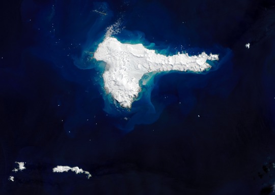
Elephant Island by Landsat 8
“When explorer Ernest Shackleton and the crew of Endurance lost their ship to crushing pack ice in the Weddell Sea in 1915, their chances of survival seemed dim. The 28 men spent months drifting on ice floes and traversing the Southern Ocean in small lifeboats until they finally spotted land. The hunk of rock and ice was not the welcoming refuge they hoped for, but it was enough.
Shackleton and the crew of the Imperial Trans-Antarctic expedition landed on the mountainous, ice-covered island today known as Elephant Island. Some say Elephant Island got its name from the sighting of elephant seals along its shores; others suggest it comes from its appearance as an elephant head. But Shackleton’s captain claimed it was a nickname given by the crew: ‘Hell-of-an-Island.’
The image above shows a rare, cloud-free view of the remote island on December 13, 2020, as captured by the Operational Land Imager (OLI) on Landsat 8. The highest points, Mount Pendragon (970 meters or 3,200 feet) and Mount Elder (945 meters or 3,100 feet), are located on the southern side. In the center, Endurance glacier collects most of the ice flowing in the southeast direction.
Elephant Island is located about 250 kilometers (150 miles) northeast of the tip of the Antarctic Peninsula. Geologically, the island is part of the Scotia Plate, which was formed from continental fragments that once formed a land bridge between South America and Antarctica. The rocky island is comprised of green and blue phyllites, blueschists, and greenschists along the coast and in ridges.
Elephant Island has few plants or animals, save for some seals and gentoo and chinstrap penguins. Although it is in a prime location for observing whales, the island is not well visited and has remained relatively under-studied due to its remoteness and difficult terrain.
Shackleton and his crew initially landed on the eastern coast at Cape Valentine, but falling rocks and the proximity to the sea made it difficult to set up safe campsites. In fact, much of the island’s coastline consists of cliffs with steep slopes rising more than 100 meters (330 feet) in places. Crew member Frank Wild scouted more stable ground to the west, with lower elevation but also more glaciers. The team set up camp, naming the site Point Wild.
Shackleton realized their chances of getting rescued from Elephant Island by passing ships were low, so he and five crewmates took a lifeboat to look for help, leaving Wild in charge.
The remaining crew built makeshift huts by resting their two remaining lifeboats upside down on rocks. To combat the perpetual darkness, they made lamps out of sardine tins, used surgical bandages for wicks, and burned seal blubber oil. Four and a half months later, Shackleton and crew returned with a ship and rescued all 22 men. King George V recognized Wild’s leadership as ‘instrumental in maintaining their courage and hope.’
Today, the island hosts one small research station occupied during the summer. At Point Wild, a monument was erected to honor the crew and their experience on the island.
[Author: NASA Earth Observatory image by Joshua Stevens, using Landsat data from the U.S. Geological Survey. Story by Kasha Patel.]” - via Wikimedia Commons
#picture of the day#picture of the day 12/13/2024#gotta be the longest desc i have ever seen on a wiki commons page#wikipedia#wikipedia pictures#wikimedia commons#nature#nasa earth observatory#u.s. geological survey#ernest shackleton#weddell sea#elephant island#wikipedia picture of the day#wikimedia picture of the day#island#southern ocean#ocean#oceancore#sea#ocean aesthetic#landsat#l
12 notes
·
View notes
Note
This might be a bit of a random and tangety question, but I was wondering if y’all also experience the erasure of people already livin’ in areas about to be or in the process of gentrification.
Cause I’m from the Mornington peninsula, this relatively mid sized region in Australia, some of it can be pretty rural, over all we have a population density of 230 per square km (which is 88 per square mile??) which is mostly because of the few bigger population centres.
Anyhow when I was growin’ up the ninch (as we call it) was seen as this largely poor, backwards, farming/fishing region full of conservatives who hated outsiders or somethin’ (to be honest the last part is correct)
But these days a lot of people have shifted from viewing people on the ninch from backwards hill dwellers to… not even existing?
A lot of our towns are seen as desirable as holiday realestate but this hasn’t rehabilitated people from the ninch in the eye’s of outsiders but instead they just ignore that we are even here, and that they are displacin’ us.
Does this happen in gentrified parts of Appalachia or are outsiders still hostile to locals?
i definitely do still notice hostility, but in a way, it can absolutely be framed as them just... not seeing us, like you said. they aggressively want to scrub clean the culture n the people to get to the pretty parts, to the point where, no, they don't consider us unless they're looking down on us as they "clean up the place."
ppl will come here n complain about how UnSaFe it is cause they hear guns going off in the woods with ppl just mindin their business, hunting on their own land or just shootin having fun. they come here n mock our accents and the way we live, pearl clutching bc they have to drive two hours away to get to a Target. then they just start filling in the commercial gaps instead of accepting that just aint how we live here. things like that.
basically, they want a pretty lil mountain view out the back of their vacation home, but they don't actually want the mountains; they want it to be like where they came from. hell, sometimes they dont even want the view. theyll flatten ridges to build their mcmansions instead. so, no, gentrification definitely hasn't redeemed appalachians in the eye of the general public that flock here, either.
anyway, solidarity <3 sounds like there's a lot in common between our region and yours
17 notes
·
View notes
Text
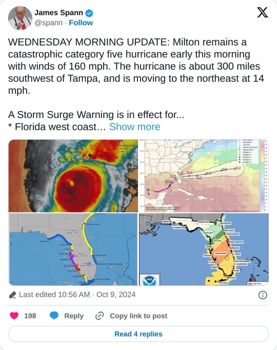
Woo yay yippieeee even :(
From James spann Twitter (above imbed):
WEDNESDAY MORNING UPDATE: Milton remains a catastrophic category five hurricane early this morning with winds of 160 mph. The hurricane is about 300 miles southwest of Tampa, and is moving to the northeast at 14 mph. A Storm Surge Warning is in effect for... * Florida west coast from Flamingo northward to Yankeetown, including Charlotte Harbor and Tampa Bay * Sebastian Inlet Florida to Altamaha Sound Georgia, including the St. Johns River A Hurricane Warning is in effect for... * Florida west coast from Bonita Beach northward to Suwannee River, including Tampa Bay * Florida east coast from the St. Lucie/Martin County Line northward to Ponte Vedra Beach From NHC Milton is moving northeastward at 12 kt in the flow between a mid-to upper-level trough over the northern Gulf and a ridge located over the Greater Antilles. This motion should generally continue until Milton makes landfall in Florida, which is likely to occur late tonight or early tomorrow morning. After the hurricane reaches the coast, a turn to the east-northeast is expected as another trough approaches the system from the west. Milton should exit Florida and move over the Atlantic waters tomorrow afternoon and accelerate eastward after that. The NHC track forecast is nudged a little to the north of the previous one to be in better agreement with the latest models. It should be noted that this forecast is based on the model fields, not the interpolated models which appear to be too far south. Users are urged not to focus on the exact landfall point as the average error at 24 hours is about 40 miles. The global models agree that vertical wind shear is expected begin to increase over Milton later today, and that should cause some weakening. However, there is high confidence that Milton will remain a very dangerous hurricane when it reaches Florida, and maintain hurricane status as it moves across the state. The cyclone is expected to become extratropical over the Atlantic on Friday and gradually weaken. The NHC intensity forecast is similar to the previous one and near the high end of the model guidance. Milton's wind field is expected to grow considerably in size while it moves across Florida. Additionally, a large region of tropical storm and hurricane-force winds could occur on the northwest/back side of the storm since Milton will be interacting with a frontal boundary and beginning extratropical transition. Damaging winds, life-threatening storm surge, and heavy rainfall will extend well outside the forecast cone. This is a very serious situation and residents in Florida should closely follow orders from their local emergency management officials. Evacuations and other preparations should be rushed to completion. Milton has the potential to be one of the most destructive hurricanes on record for west-central Florida. Key messages *A large area of destructive storm surge, with highest inundations of 10 ft or greater, is expected along a portion of the west-central coast of the Florida Peninsula. If you are in the Storm Surge Warning area, this is an extremely life-threatening situation, and you should evacuate as soon as possible if ordered by local officials. *Devastating hurricane-force winds are expected along portions of the west coast of Florida, where a Hurricane Warning is in effect. Milton is forecast to remain a hurricane while it crosses the Florida Peninsula and life-threatening hurricane-force winds, especially in gusts, are expected to spread inland across the peninsula. Preparations to protect life and property, including being ready for long-duration power outages, should be rushed to completion. *Heavy rainfall across the Florida Peninsula through tomorrow brings the risk of catastrophic and life-threatening flash and urban flooding along with moderate to major river flooding, especially in areas where coastal and inland flooding combine to increase the overall flood threat.
Stay safe y'all.
11 notes
·
View notes
Text
Assorted Venomous Noodles

...wow that looks empty with all the names hidden. It's not actually much better with them there—snakes don't tend to take up much room. You can try to guess which is which, and I'll try to figure out what to say about a bunch of snakes with short descriptions. I don't... get snakes, so they'll probably be pretty spare.
The Mlegtugwam
The Mlegtugwam is a kind of snake found mainly in crevices in cliff faces throughout most of Europe. There are several species of Mlegtugwam, each with its own range, though they all look very similar, with slate-grey scales, and most of them have a dashed or solid line down the middle of their back. They are venomous, but do not bite unless physically grabbed or trapped in the open, as they much prefer to hide in crevices when they feel threatened.
The Girtranaeg
The Girtranaeg is a snake found in the Valdivian forests in South America. It has pale green iridescent scales, and it kills its prey through constriction.
The Hrukgolklo
The Hrukgolklo is a two-headed snake found in Mexico. It can be distinguished by the unique coloration of its scales—bright white and dark red stripes, with thin gold bands between them. It is not venomous enough to pose a threat to humans, and on top of this is slow to bite unless it has been injured.
The Thagolgrom, Shabalrang, Tafmiwukri, Krefemklog, and Nrogklongo
The Thagolgrom, Shabalrang, Tafmiwukri, Krefemklog, and Nrogklongo are five different species of asp who together range from southern Europe to India to northern Africa. Though each is found in a different area, each range overlaps with at least two others, which causes great confusion due to the similarity of their appearances.
It is crucial to be able to tell them apart, however, as all of them are highly venomous and aggressive, and treatment must be specific to the snake. While each venom has distinctly different effects on the body, it is inadvisable to identify them in this way, as at the point they become distinct, not only is the victim likely to be in incredible pain, but their chances of survival are extremely low even if treated as soon as the symptoms become apparent.
The Kraehozdim
The Kraehozdim is a snake found in Italy. It is large, with black scales and a sandy-colored belly, and it tends to make its home in fields and pastures. It kills via constriction, and has been known to target livestock.
The Samgleshti
The Samgleshti is a snake found in the deserts of Africa. It is the color of sand, in which it buries itself partially for camouflage, waiting for prey to draw near. It can easily be identified by the four horn-like protrusions on its head���one at the tip of its nose, one between its eyes, and two ridges on the sides of its snout.
The Zriggwanto
The Zriggwanto is a flying snake found in forests in Great Britain, particularly Wales, with grey scales. It is venomous, but rarely attacks humans.
The Kramlengga
The Kramlengga is a flying snake found in the Arabian peninsula. It is white, and has an unusual method of flattening its body to an even greater extreme than other flying snakes, and twisting it in midair.
The Galwinglik
The Galwinglik is a small snake found everywhere from the southern United States to Brazil. It is rather unassuming and a solid blue-black in color, and it is generally very reclusive. Its venom is very strong and causes excruciating pain and slow paralysis.
The Yeakindra
The Yeakindra is a small snake found throughout most of East and Southeast Asia. It is a mottled brown in color, lending it excellent camouflage in soil or leaves, and its venom is so strong that most bitten by it do not survive long enough to be treated.

#maniculum miscellaneoussnakes#mlegtugwam#girtranaeg#hrukgolklo#thagolgrom#shabalrang#tafmiwukri#kretemklog#kraehozdim#nrogklongo#samgleshti#zriggwanto#kramlengga#galwinglik#yeakindra#<- casting spell of summon fourteen snakes#bestiary#worldbuilding#fiction writing#strix draws things
8 notes
·
View notes
Text
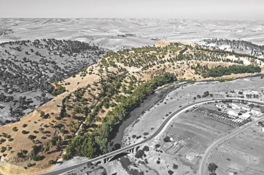
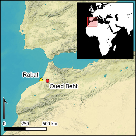
Maghreb, Oued Beht, and Agriculture
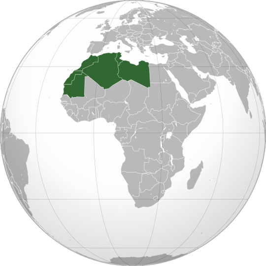
By Connormah - Own work, CC BY-SA 3.0, https://commons.wikimedia.org/w/index.php?curid=8986151
Al-Maghrib (اَلْمَغْرِب) or the Maghreb is 'the place where the sun sets', or Northwest Africa, has a long history of being inhabited with the Berber people living there since 10,000 BCE, from when the Sahara was green. It is partially isolated from the Middle East by the Atlas Mountains as well as the Sahara and spans the modern-day countries of Algeria, Libya, Mauritania, Morocco, Tunisia, and Western Sahara. It was previously thought that it wasn't until trade relations with the Phoenicians that it was connected to the rest of the ancient world.
Source: https://scitechdaily.com/rewriting-history-archaeologists-discover-a-lost-african-civilization-as-big-as-troy/
Oued Beht, or the Baht River is a river in Morocco that flows from the Middle Atlas mountains to the Atlantic Ocean. It was known this area played a role during the Paleolithic, with the Green Sahara making travel much easier and again when the Phoenicians set up their city of Carthage in modern-day Tunisia, but the time between was not well studied. With its close connection to the Iberian Peninsula, though, researchers thought that there should have been more development in the area than a continuation of hunter-gatherer or pastoral societies, especially with developments in Iberia of settled agriculture and mining in the Copper and Bronze Ages. The researchers set out to study this time period and correct this gap in knowledge.
Source: https://www.cambridge.org/core/journals/antiquity/article/oued-beht-morocco-a-complex-early-farming-society-in-northwest-africa-and-its-implications-for-western-mediterranean-interaction-during-later-prehistory/D4C36054F6B0D2D3FB4F0A0FE9BCE6C0
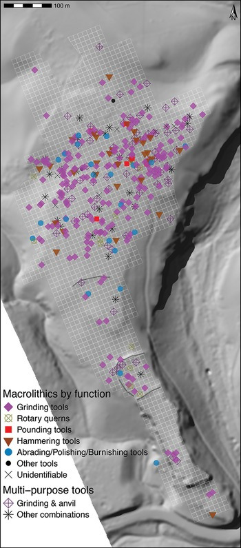
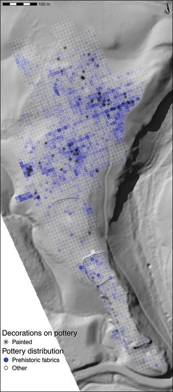
They chose the site of Oued Beht as it had been studied in the 1930s by the French colonizers and many stone tools and what were taken to be walls were found at the time, resulting in at east 1388 items currently held in the Rabat Museum (Musée de l'Histoire et des Civilisations) and the INSAP (Institut National des Sciences de l'Archéologie et du Patrimoine) and many more believed looted. They began their study focusing on Ifri n'Amr o'Moussa cave, finding burials dated to 5210-4952 BCE and domesticated barley. They then began studying the open areas near the cave. Dating of items from outside the cave range from 3400-2900 BCE, matching the dating of the style of pottery found in the area, pushing into the times that are currently 'missing' in the chronology of the area.
Source: https://www.cambridge.org/core/journals/antiquity/article/oued-beht-morocco-a-complex-early-farming-society-in-northwest-africa-and-its-implications-for-western-mediterranean-interaction-during-later-prehistory/D4C36054F6B0D2D3FB4F0A0FE9BCE6C0#article
A further study, gathering 19,626 items, drone photography, and other data using modern archaeological techniques. They also found remains of charred seeds of naked barley, wheat, pea as well as wild olive and pistachio residues. They found remains of goats, sheep, cattle, pigs, and a tooth from a horse. The remains of the animals show butchering marks. These show that for at least 500 years, probably 200 years more on either side, from the late 4th to early 3rd millennium BCE that there was 'a major concentration of activity and investment of labour and resources developed across an area of at least 9-10ha, focused on the northern part of the ridge.' The foods found were typical for the area during the Neolithic, when agriculture was developed in the eastern sections of the Mediterranean, leading to the cautious interpretation of the area being a fairly typical Neolithic village, but as these findings are rather extraordinary, caution should be exercised until further studies in the Maghreb can be done. What can be said for certain was that there was farming in the area, though it may have been related to pastoralism, farming while moving the community with flocks and herds between grazing lands, rather than settled agriculture like that seen in Mesopotamia and the Levant.
4 notes
·
View notes
Text
Gonna be delulu and ilustrate the whole Darklina moment of Chapter 9 in Ruin and Rising because it's my favorite scene of them and I'm just obsessed keep it up with my new hyperfixation!
Here we have:
HE WAS SITTING on the edge of a table, his shirt crumpled into a ball at his knee, his arms raised above his head as the vague shape of a Corporalnik Healer came in and out of focus, tending to a bloody gash in the Darkling’s side. I thought at first we might be in the infirmary at the Little Palace, but the space was too dark and blurry for me to tell.
I tried not to notice the way he looked—his mussed hair, the shadowed ridges of his bare chest. He seemed so human, just a boy wounded in battle, or maybe sparring. Not a boy, I reminded myself, a monster who has lived hundreds of years and taken hundreds of lives.
His jaw tensed as the Corporalnik finished her work. When the skin had knitted together, the Darkling dismissed her with a wave. She hovered briefly, then slipped away, fading into nothing.
“There’s something I’ve been wondering,” he said. No greeting, no preamble.
I waited.
“The night that Baghra told you what I intended, the night you fled the Little Palace, did you hesitate?”
“Yes.”
“In the days after you left, did you ever think of coming back?”
“I did,” I admitted.
“But you chose not to.”
I knew I should go. I should at least have stayed silent, but I was so weary, and it felt so easy to be here with him. “It wasn’t just what Baghra said that night. You lied to me. You deceived me. You …drew me in.” Seduced me, made me want you, made me question my own heart.
“I needed your loyalty, Alina. I needed you bound to me by more than duty or fear.” His fingers tested the flesh where his wound had been. Only a mild redness remained. “There are rumors that your Lantsov prince has been sighted.”
I drifted nearer, trying to keep my voice casual. “Where?”
He glanced up, his lips curling in a slight smile. “Do you like him?”
“Does it matter?”
“It’s harder when you like them. You mourn them more.” How many had he mourned? Had there been friends? A wife? Had he ever let anyone get that close?
“Tell me, Alina,” said the Darkling. “Has he claimed you yet?”
“Claimed me? Like a peninsula?”
“No blushes. No averted eyes. How you’ve changed. What about your faithful tracker? Will he sleep curled at the foot of your throne?”
He was pressing, trying to provoke me. Instead of shying away, I moved closer. “You came to me wearing Mal’s face that night in your chambers. Was it because you knew I would turn you away?”
His fingers tightened on the table’s edge, but then he shrugged. “He was the one you longed for. Do you still?”
“No.”
“An apt pupil, but a terrible liar.”
“Why do you have such disdain for otkazat’sya?”
“Not disdain. Understanding.”
“They’re not all fools and weaklings.”
“What they are is predictable,” he said. “The people would love you for a time. But what would they think when their good king aged and died, while his witch of a wife remained young? When all those who remember your sacrifices are dust in the ground, how long do you think it will take for their children or their grandchildren to turn on you?”
His words sent a chill through me. I still couldn’t get my head around the idea of the long life that lay ahead of me, that yawning abyss of eternity.
“You never considered it, did you?” said the Darkling. “You live in a single moment. I live in a thousand.” Are we not all things?
In a flash, his hand snaked out and seized my wrist. The room came into sudden focus. He yanked me close, wedging me between his knees. His other hand pressed to the small of my back, his strong fingers splayed over the curve of my spine.
“You were meant to be my balance, Alina. You are the only person in the world who might rule with me, who might keep my power in check.”
“And who will balance me?” The words emerged before I thought better of them, giving raw voice to a thought that haunted me even more than the possibility that the firebird didn’t exist. “What if I’m no better than you? What if instead of stopping you, I’m just another avalanche?”
He studied me for a long moment. He had always watched me this way, as if I were an equation that didn’t quite tally.
“I want you to know my name,” he said. “The name I was given, not the title I took for myself. Will you have it, Alina?”
I could feel the weight of Nikolai’s ring in my palm back at the Spinning Wheel. I didn’t have to stand here in the Darkling’s arms. I could vanish from his grip, slide back into consciousness and the safety of a stone room hidden in a mountaintop. But I didn’t want to go. Despite everything, I wanted this whispered confidence.
“Yes,” I breathed.
After a long moment, he said, “Aleksander.”
A little laugh escaped me. He arched a brow, a smile tugging at his lips. “What?”
“It’s just so … common.” Such an ordinary name, held by kings and peasants alike. I’d known two Aleksanders at Keramzin alone, three in the First Army. One of them had died on the Fold.
His smile deepened and he cocked his head to the side. It almost hurt to see him this way. “Will you say it?” he asked.
I hesitated, feeling danger crowd in on me.
“Aleksander,” I whispered.
His grin faded, and his gray eyes seemed to flicker.
“Again,” he said.
“Aleksander.”
He leaned in. I felt his breath against my neck, then the press of his mouth against my skin just above the collar, almost a sigh.
“Don’t,” I said. I drew back, but he held me tighter. His hand went to the nape of my neck, long fingers twining in my hair, easing my head back. I closed my eyes.
“Let me,” he murmured against my throat. His heel hooked around my leg, bringing me closer. I felt the heat of his tongue, the flex of hard muscle beneath bare skin as he guided my hands around his waist. “It isn’t real,” he said. “Let me.”
I felt that rush of hunger, the steady, longing beat of desire that neither of us wanted, but that gripped us anyway. We were alone in the world, unique. We were bound together and always would be.
And it didn’t matter.
I couldn’t forget what he’d done, and I wouldn’t forgive what he was: a murderer. A monster. A man who had tortured my friends and slaughtered the people I’d tried to protect.
I shoved away from him. “It’s real enough.”
His eyes narrowed. “I grow weary of this game, Alina.”
I was surprised at the anger that surged to life in me. “Weary? You’ve toyed with me at every turn. You haven’t tired of the game. You’re just sorry I’m not so easily played.”
“Clever Alina,” he bit out. “The apt pupil. I’m glad you came tonight. I want to share my news.” He yanked his bloody shirt on over his head. “I’m going to enter the Fold.”
“Go ahead,” I said. “The volcra deserve another piece of you.”
“They will not have it.”
“You hope to find their appetites changed? Or is this just more madness?”
“I am not mad. Ask David what secrets he left for me to discover at the palace.”
I stilled.
“Another clever one,” said the Darkling. “I’ll be taking him back too, when this is all over. Such an able mind.”
“You’re bluffing,” I said.
The Darkling smiled, but this time the turn of his lips was cold. He shoved off the table and stalked toward me.
“I will enter the Fold, Alina, and I will show West Ravka what I can do, even without the Sun Summoner. And when I have crushed Lantsov’s only ally, I will hunt you like an animal. You will find no sanctuary. You will have no peace.” He loomed over me, his gray eyes glinting. “Fly back home to your otkazat’sya,” he snarled. “Hold him tight. The rules of this game are about to change.”
The Darkling raised his hand, and the Cut tore through me.
6 notes
·
View notes
Note
whats your favourite place in the Mornington peninsula? I remembered id actually visited a few years ago but i didnt get to do much exploring :/
and also how are you doing? <3
ooooh that’s a really hard answer… id say either main ridge, redhill south, shoreham or glenvue residential caravan park. but to be honest i genuinely dont have a favourite im like a parent with their children. i do have a couple of least favourites but even then there are charms about them that make it impossible to create a real ranking.
im doing good!! mystery stomach ache is trying to kill me and i haven’t had anyyy time of work lately to go wander around which sucks but yk it is what it is. how about you? how’s the music going?
2 notes
·
View notes
Text
Made it out to see the snow geese! It wasn't any more crowded than a normal Saturday during the big migration, so I guess the news that the viewing area was open again, after the bird flu closure for most of the migration season, had not spread widely.
Most of the birds were in the less-viewable portion of the lake, but there were a lot! Here's a webcam picture from earlier in the day, before I was there:

Here's my picture of where the webcam is:

This is looking over toward where the densest part of the flock was:

Go full-screen on these to see a little better, but that white band on the water, that you can see through the trees, is hundreds and hundreds of birds.
The other side of this little peninsula has an unobstructed view of the lake, but there was a strong, gusty wind coming from that direction, so most of the birds chose the sheltered side.

Shortly after I took these, a bald eagle flew over, and about 2/3 to 3/4 of the flock took wing.
As they were swirling around, you could see that the ones trying to fly into the wind, toward us, were not making much headway, and they flew off over to that ridge you can see in the background of the pictures. So we didn't get the very cool flyover like I was lucky enough to experience last year, but we could hear the thunder of their wings for a moment or two.
My phone camera isn't nearly good enough to catch it, but as they were swirling over the ridge, deciding where to land, they looked like clouds of glitter against the bright blue sky.
Depending on how things look on the livestream, I might head over again on Wednesday--with the clocks going forward tonight, I'll be done with work in plenty of time. It's supposed to be less windy, which means the geese might give us a better view, but it's also going to be pretty warm, so they might be on their way to their next stop, the Finger Lakes of upstate New York by then--we'll just have to see!
3 notes
·
View notes
Text
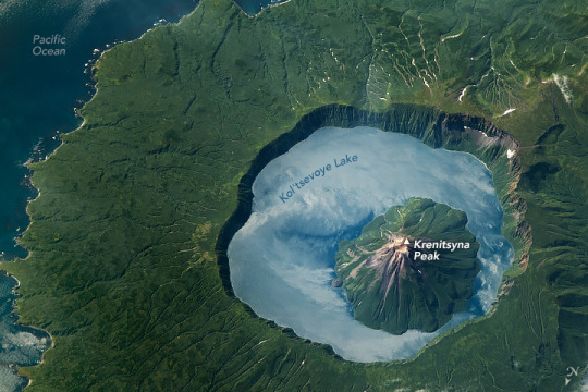
Exploring Russia’s Krenitsyna Volcano
An astronaut aboard the International Space Station took this photo of Onekotan Island while orbiting over the northwest Pacific Ocean. Onekotan is part of the Kuril Islands, an archipelago extending between the Kamchatka Peninsula in Russia and Hokkaido in Japan. The photo shows Krenitsyna Volcano, located on the southern side of the island.
The low-oblique angle of the photograph accentuates the terrain, particularly cliffs, coastlines, and mountains. Note that the photo has been rotated (north is down) to minimize an optical illusion known as relief inversion.
The Tsar-Rusyr caldera is the crater-like depression visible in this image. Calderas form when the ground collapses into a partially emptied magma chamber during a large eruption. This caldera is surrounded by steep 300-meter (1000-foot) cliffs that cast shadows along the eastern interior of the volcano.
The caldera holds the blue waters of Kol’tsevoye Lake, which contrasts with the surrounding vegetated summer landscape. Reaching depths of up to 370 meters (1,200 feet), the lake is one of the deepest in Russia. Its surface reflects sunlight back to the camera, producing sunglint, and it also mirrors the clouds drifting above the central peak.
Situated at the center of the caldera is Krenitsyna Peak, which stands approximately 1,300 meters (4,200 feet) above sea level. The slopes of this stratovolcanic peak consist of dark-colored valleys and ridges, caused by volcanic flows and erosive processes, that reach the surface of Kol’tsevoye Lake. The last eruption of this complex occurred in November 1952 and was categorized as “moderate,” with a Volcanic Explosivity Index (VEI) of 3.
West of the caldera, a mountain system is visible on the right side of the image. This rugged terrain contrasts with the opposite side of the caldera, where the landscape flattens out as it reaches the Pacific Ocean. Small patches of bright snow and ice remain in the valleys between the mountain and the coastline.
Astronaut photograph ISS069-E-71110 was acquired on August 19, 2023, with a Nikon D5 digital camera using a focal length of 1,150 millimeters. It is provided by the ISS Crew Earth Observations Facility and the Earth Science and Remote Sensing Unit, Johnson Space Center. The image was taken by a member of the Expedition 69 crew. The image has been cropped and enhanced to improve contrast, and lens artifacts have been removed. The International Space Station Program supports the laboratory as part of the ISS National Lab to help astronauts take pictures of Earth that will be of the greatest value to scientists and the public, and to make those images freely available on the Internet. Additional images taken by astronauts and cosmonauts can be viewed at the NASA/JSC Gateway to Astronaut Photography of Earth. Caption by Chloe Locke, JETS II Contract at NASA-JSC.
5 notes
·
View notes