#meromictic lakes
Explore tagged Tumblr posts
Visit Tumblr Blog
Explore Tumblr blogs with no restrictions, modern design and the best experience.
Last Seen Tumblr Blogs


Fun Fact
70% of Tumblr users say the Dashboard is their favorite place to spend time online.
Text

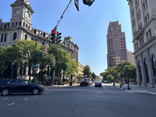
Crawford Lake
Crawford Lake is meromictic, meaning its layers do not mix. (Another meromictic lake is McGinnis Lake at the Petroglyphs Provincial Park.)
According to Conservation Halton's website, "In the deepest part of the lake 75 ft below the surface, sediment is deposited in annual layers and remains totally undisturbed. Scientists researching this sediment in the early 1970s discovered corn pollen dating from the 13th to 15th century. This led to the discovery of the archaeological footprints of a Wendat or Attawandaron village."
Photograph taken on July 30, 2023, at Crawford Lake Conservation Area, Milton, Ontario, Canada.
#wildflowers of southern ontario#Crawford Lake#Crawford Lake Conservation Area#conservation area#nature#lake#Milton#Ontario#Canada#meromictic#meromictic lake
21 notes
·
View notes
Text
BLOG 1: My Relationship with Nature 🦋
My relationship with nature has grown from many different experiences throughout my life, leading me to a place where nature excites me, inspires adventure within me while also calming and soothing me. I grew up camping with my family every summer, at first in tents and eventually graduating to a cute pop-up trailer. I always loved tending to the fire are night and swimming in the lake during the day. My family is not outdoorsy by any means, but they helped introduce me to practical outdoor skills which in my adult life I hope to continue to explore and grow.
The main contributor to my relationship with nature, which offered me a “sense of place”, is my connection to Conservation Halton. Here I have worked for the past two years as a summer camp counsellor in their Ways of the Woods day camp program. Ways of the Woods camps put an emphasis on outdoor education. At this job I gained my first experience as a type of interpreter. Taking the kids on hikes around the four conservation areas (Kelso, Mountsberg, Crawford, and Area 8), and teaching them skills such as archery, canoeing and kayaking, fishing, axe throwing etc. I love my job so much as I get to be in the beautiful outdoors all day. Hiking on the escarpment and swimming in the lake. It is so beautiful to watch the kids develop confidence in the natural world and help them safely explore their natural curiosity. (Below are photos from this past summer).


The camp offers specialty streams, my two favourite to work being farm camp and survivalist camp. At farm camp we interact with farm animals, and we work in the conservation area’s produce garden. The kids get to take home a harvest at the end of the week and literally see the fruits of their labour. One of the best things about the Ways of the Woods camps is the weekly trip to Crawford Lake. Here we educate the kids on the amazing properties of the unique meromictic lake. We also visit the longhouses and Indigenous knowledge area where education staff teach the kids about Indigenous ways of living and knowing that were originally practiced around the lake. Understanding this perspective is integral to connecting with nature.
Working this job has helped to grow my confidence with the outdoors. I feel comfortable in the role of an educator even though I am still a student myself. The sense of community at Ways of the Woods supports sharing of outdoor passions and knowledge. I have even been on camping trips with my coworkers outside of work as we discovered our joint interest (of course we hiked by also spent hours playing spike ball). I can admit to feeling like an imposter in the outdoorsy community as I have never back country camped or hiked a huge mountain, but I am trying to remind myself that I am, and will always continue to, be a student of the earth, constantly learning through exploration.
In the coming years I want to explore more through backpacking. However, outdoor hobbies can be expensive. If anyone has any tips, tricks, or recommendations please leave them below!
3 notes
·
View notes
Note
So now I’m curious:
What are the Three Big Lakes of Africa?
Signed,
Geographically-challenged American 😆
Tee hee! Thanks for being curious!
So the Maziwa Makuu, known as the African Great Lakes, all lie within the tropical zone along the Great Rift Valley in East Africa. Collectively they contain a quarter of the world's fresh unfrozen surface water and about a tenth of the world's species of fish.
The largest is Nyaza (Lake Victoria), second largest in the world by area after Superior. It's the primary source of the White Nile and is surrounded by Kenya, Tanzania, and Uganda.
Next is Lake Tanganyika, the longest lake in the world, the second largest by volume and, at a depth three and a half times that of Superior, it's also the second deepest. Its youngest basin has been around for over 3 million years and its oldest for around 10. (Lake Baikal in Siberia is the deepest, biggest by volume, and oldest.) Tanzania, DRC, Zambia, and Burundi share it, although it probably laughs at the notion of nations.
Lake Malawi is the third by area, although second by depth (almost twice as deep as Superior) and is another ancient lake. It is alkaline and also meromictic, so the upper and lower waters don't mix. It contains the most species of fish of any of the world's lakes, and as the water is remarkably clear and averages 80°F at the surface, it's fantastic for snorkling and diving. Tanzania also borders this lake, along with Malawi and Mozambique.
:)

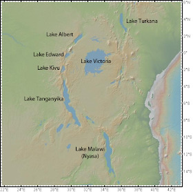
(Oh, and although not one of the Great Three Lakes, Turkana is in the Rift Valley System and I'd forgive you if you remember it as Lake Turukáno. In fact, I'll be impressed if its remembered at all!) 😉
28 notes
·
View notes
Text
Ever just think about how fucking cool jellyfish are?
And meromictic lakes those are fucking cool as well
#it's almost one am why am i so awake#come monday I'll be exhausted as per usual#council rants#but why are there only three limnically active lakes i want to learn more about these
3 notes
·
View notes
Text
We went out to Crawford Lake the other day (if that names sounds familiar to you it was in the running as a site for a marker for the start as the anthropocene). If you're going to go, I highly recommend getting the Lake to Longhouse tour. At the end of the tour, our guide took us down to the lake, and explained about it being a meromictic lake, and how that led to the undisturbed sediment layers. There's apparently only 13 in Canada (makes sense, after all it's a special quality of the lake, not something common) and 50 in the entire world.
Hold up here. I know we have a large landmass, but we have 1/4 of the (known) meromictic lakes in the world??? I know that other countries just don't have a lot of lakes (my my standards), but that's got to be a case of them just not finding them, right? (Although... if you live in a sufficiently temperate climate do lakes mix at all? Does it not count as a meromictic lake unless you live somewhere that gets cold enough that you'd expect the lake to turn over twice a year?)
1 note
·
View note
Text
Camillus to Canastota
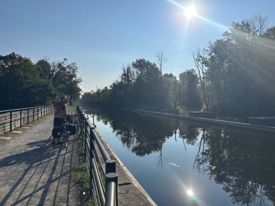
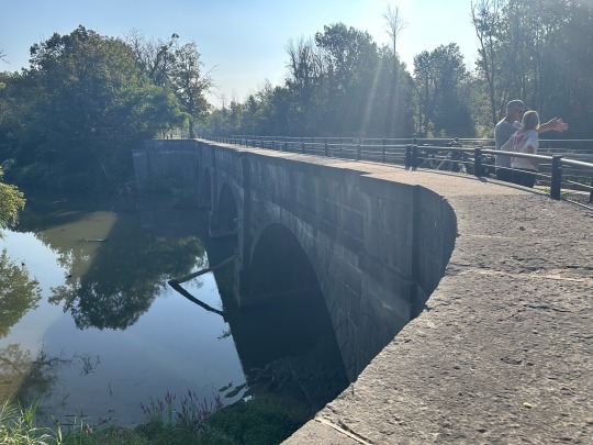
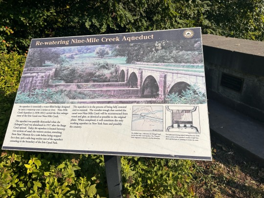
Camillus is synonymous with hills to me! We had the big hill up to the Nightshade Inn & Gardens yesterday (which was fun going down this morning) and more hills on the other side of Camillus as we headed east toward Syracuse. Camillus has a cute Old Erie Canal Park that we passed soon after we got back to the trail. We also saw the Nine Mile Creek Aqueduct early in our day.
We passed the state fairgrounds near Syracuse. It ended Sept 4th, but it had been going in full force as we passed it on the train last Thursday. There was actually a train stop there.
As we came into Syracuse, we had a nice view of Onondaga Lake and the Inner Harbor (no picture).


The bridge got us over the train tracks. I got a photo op and Rob got a train - win-win.
The ride through Syracuse was pretty easy. We went through the lake front area and what felt like the middle of town with some cute restaurants (right along I-690). We didn’t stop other to run into a bike shop on the east side of town. Too late for breakfast and too early for lunch. The ride on the east side of Syracuse was interesting with the trail in the median of a fairly large roadway. It had lots of stops to navigate the traffic, but at least it had bike signals to get us through safely.
We did take a detour today to the Green Lakes State Park. There are 2 glacier formed lakes that are an amazing blue green color. I read it is that color because of the high amounts of calcium carbonate in the water. We ran into a couple on the trail today, and they explained that it is very unusual lake because it is a meromictic lake, meaning it has no seasonal lake mixing. We rode our bikes around the lake, and it was just gorgeous. At one end they had a “beach” and swimming. The swimming looked refreshing, but the beach was …. dirt.


Over 43 miles with the detours. Forgot to mention that the last 20 miles or so today was in the Old Erie Canal State Historic Park. The trails were great and well maintained.
0 notes
Text
Day 84 - to forest at the south of Lake Pavin
The mountains as one looks to the south from Col de Serre, are the remnants of r Volcanoes of Cantal, the largest stratovolcano or conical volcano of Europe, which was formed from 13 million years ago and last erupted approximately 2 million years ago.


This morning, after three days here, I was reluctant to leave them. I went out expecting to be less than an hour, and we were out for double that. Once on the grassy ridge above, the view was uninterrupted for the first time, and it was impossible not to linger. Roja is a big fan of those tiny tarns, or lochans, found high up on mountain plateaus. His favourite, where he likes to go for his birthday, is on High Street, just before High Raise. We found another today, and while I lingered, savoured and pondered the skyline, he took to the waters, or the lido as we say in the Lakes.


We drove on to the north for 45 minutes to another area with remaining evidence of the volcanoes, around the ski area of Besse, where there are several crater lakes, the most scenic and visited being Pavin, which gives its name to a cheese also. Lake Pavin is a meromictic lake, one in which the layers of water do not intermix, as opposed to the more usual, holmictic lakes, in which at least once a year, the surface and deep waters mix. My pictures don’t do it justice, but the colours, shades of green and blue, are very different to what would be expected. Along with a French couple, I stood watching a two foot long Arctic Char saunter about in the shallows just after Roja had retrieved a stick, he must have awoken it from a slumber.

The circuit of the lake is only about three kilometres and popular, even today. I extended it a bit, and took in the peak, Puy de Montchal, at 1407 metres, which gave some excellent views. There was some cloud today, but quite a bit of sun also, though the temperature never got above 10C. This time last year I was in a heatwave in the Vosges, not that far from here.


We haven’t moved far from the big car park at Lake Pavin. Quite a few motorhomes were staying put there, but it was only just off the main road, which was noisy. We took some minor roads and tracks into the forests at the south side of the lake and found an isolated forest pull-in. It did have the first mosquitos thought of this spring, quite surprising with the temperature, though I guess after all the rain we have had. They seemed to like the late afternoon best also, as at dusk, with the temperature lower again, they were nowhere to be seen.

0 notes
Text


Hiked around on an escarpment overlooking a small valley and a trail around a lake the other day. The lake I got to see is classified as a meromictic lake, which is a somewhat rare type of lake. Due to their incredible depth they are separated into 3 distinct layers usually with the bottom most layer being almost entirely anaerobic, which is really only suitable for the purple sulphur bacteria that dwell there. The lake has no seasonal turnover, so none of the layers ever gets mixed, meaning there's little disturbance aside from the microbes that live there, and organic material that falls into the depths. This means that whatever falls in and settles there, stays there, which has played an important role in determining the geologic history of the area. In the case of this lake, grains of corn pollen were observed in a core sample of the lake bed at around the 1600's mark, which indicated the presence of an indigenous settlement in the area at the time. This led to a further investigation in the surrounding area and they were able to find various tools, weapons, pottery, etc.
#plants#botany#nature#hiking#plant science#meromictic lakes#meromictic lake#lake#views#history#water#core sampling#core sample#natural history#cool#interesting#anaerobic#science
5 notes
·
View notes
Photo


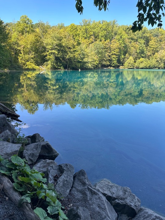
Outside - Crawford Lake Conservation Area, Halton, ON
#photo365#outside#hiking#nature#ontario#chickadee#wildlife photography#lichen#botany#iroquoian village#longhouse#Indigenous#meromictic lake
4 notes
·
View notes
Photo


McGinnis Lake, Petroglyphs Provincial Park
McGinnis Lake is a meromictic lake, in which the layers of water (i.e., surface, deep, and between these two) do not intermix.
Photographs taken on June 20, 2023, at Petroglyphs Provincial Park, Woodview, Ontario, Canada.
#wildflowers of southern ontario#Petroglyphs Provincial Park#McGinnis Lake#Petroglyphs#nature#provincial park#park#lake
15 notes
·
View notes
Photo

Alatsee in Germany. Photo taken by me. Found this interesting stuff on wikipedia: “Alatsee is a meromictic lake (which has layers of water that do not intermix). Many divers have died or disappeared mysteriously in this lake due to the toxicity of the organisms living in this lake. These organisms create the "blood cloud " that occurs quite abundantly throughout the year.”
#alatsee#germany#alat see#meromictic#lake#outside#mountains#hills#toxicity#nature#travel#layers#trees#hiking#beautiful#water#black and white#waves
14 notes
·
View notes
Text

1 note
·
View note
Note
Hi! I have a fun fact for you:
Did you know lake baikal is the oldest, deepest, and clearest lake in the world? It was formed from tectonic movements in the earth's crust. It's what's known as a meromictic lake, meaning there's a layer at the bottom that doesn't mix with the rest of the water. It's water is so clear there's a telescope set up in the lake to study neutrinos!
oh?? thats so cool actually omg :D
6 notes
·
View notes
Photo
🥾𝙀𝙓𝙋𝙇𝙊𝙍𝙀 𝙉𝙀𝙒 𝙔𝙊𝙍𝙆 Meromictic lakes are quite rare and one of the distinct things that set Green Lake and Round Lake apart from other lakes in New York State (and makes them the unique greenish color.) Learn more about visiting here: https://familyadventuresinnewyorkstate.com/green-lake-state-park-manlius-new-york/ #greenlakestatepark #meromicticlake #lake #newyorkstateparks #green #reef #amazingplaces #hiddengem #kayaking #camping #mustvisit #mustsee #uniqueplaces #summer #summerfun #hiking #hike #trails #explorenewyork #cny #centralny (at Green Lakes State Park) https://www.instagram.com/p/Cg2NimDuzsC/?igshid=NGJjMDIxMWI=
#greenlakestatepark#meromicticlake#lake#newyorkstateparks#green#reef#amazingplaces#hiddengem#kayaking#camping#mustvisit#mustsee#uniqueplaces#summer#summerfun#hiking#hike#trails#explorenewyork#cny#centralny
3 notes
·
View notes
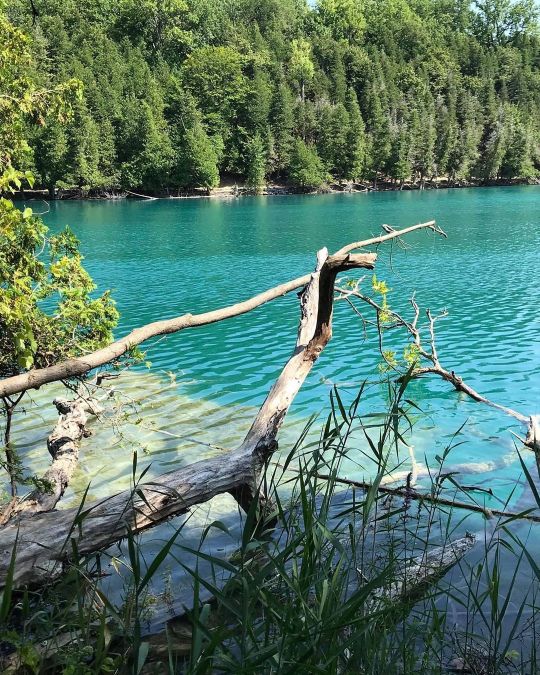
Photo

Green Lakes State Park in NY, home to two meromictic glacial lakes, giving the water a natural blue-green hue. [OC] [3642x2428].
#travel#traveling#world#asia#africa#japan#india#dubai#vocation#adventure#hotel#motel#cheap flights#cheap tickets#expedia flights#airline tickets#china airlines#air ticket#travel agency#cheap airline tickets#cheap air tickets#cheap air#cheap airfare#cheap o air#cheap plane tickets#airplane ticket#travel sites#airline flights#travel websites#travel deals
1 note
·
View note
Text
Ontario lake among finalists as scientists prepare to mark onset of the Anthropocene Epoch

Crawford Lake in Milton, Ont., is seen by a team of Canadian scientists as a kind of natural archive of evidence of humanity's impact on the Earth since the dawn of the Industrial Revolution. The lakebottom sediments also preserve traces of pre-contact Indigenous communities living along the lake shore. [Photo © Capital Current]
This piece was originally published on Capital Current. You can view it here.
Scientists from around the world are on the cusp of choosing a natural landmark to represent the point in Earth’s history when human activity began to significantly impact the planet.
A small lake in Milton, Ont., is one of 12 locations from around the world nominated to symbolize the start of the Anthropocene Epoch, a proposed new time period in the planet’s geological history typified by humanity’s unmistakable impact on the land, water and air.
Traces of pollution beginning with the Industrial Revolution, for example, as well as the enduring signature of 20th century nuclear bomb tests, are among the markers scientists can detect in the lake-bottom sediments at Crawford Lake and at other sites vying to become the so-called “Golden Spike” representing the onset of the Anthropocene.
Crawford Lake’s competitors range from Flinders Reef in Australia to the Antarctic Peninsula. The Anthropocene Working Group (AWG), made up of members of the International Union of Geological Sciences, announced the candidates at a conference in Berlin earlier this year.

Paul Hamilton, a scientist at the Canadian Museum of Nature and a researcher working on Crawford Lake’s pitch, stresses the global importance of determining the Golden Spike.
“It will be giving the starting point — a date, a time and a place — where we as the human species began to see our contribution to the disturbance of the Earth,” said Hamilton.
Francine McCarthy, a professor of earth sciences at Brock University – the main institution spearheading the case for Crawford Lake – is a voting member of the Anthropocene Working Group. She says the lake shows records of both global and local magnitude — proof of nearby Indigenous settlements that lived on the shores of the lake thousands of years ago, alongside evidence of wide-scale modern events such as the Industrial Revolution.
“The global impact was felt in this little rural, isolated lake,” she said.
Once a site is determined to be the “poster child” for the epoch, McCarthy says, the Anthropocene will be on track to becoming a part of the official geological time scale.
Tim Patterson, a researcher and scientist at Carleton University — another one of the main institutions contributing to the research on Crawford Lake — calls the geological significance of the lake “mind-boggling.”

What makes Crawford Lake so significant, Patterson says, is the way its layers interact with one another. It’s a deep, meromictic lake, meaning the layers of water don’t intermix: the top layer mixes with help from the environment – such as animal contact, rain or wind – while the bottom layer is more dense and does not combine with the top. The separation allows sediments to sink to the lake’s bottom, where they gather in distinct layers and become preserved, forming a geological snapshot of history.
McCarthy describes the sediments as being “seasonally laminated,” comparing the occurrence to the “rings inside a tree.” She and her team have spent the past four years understanding why this happens.
At Patterson’s lab, he and his research team collect evidence of the layered sediments at the bottom of Crawford Lake using a freeze core, a method commonly used to investigate lake bed sediments.
“The freeze cores are basically long chambers. You fill them up with dry ice, alcohol and slurry. Then you pound it all together, you seal it up, and you lower it to the bottom of the lake,” Patterson said.
youtube
The Anthropocene: Inside the Quest for the Human Epoch at Crawford Lake, Ontario, a video featuring scientists from Carleton University involved in extracting a lakebottom core sample during the winter at Crawford Lake. [Courtesy of Carleton University]
“Because dry ice is very cold, the lake sediment freezes to the surface of it. You pull it out after about half an hour or so and then you have a beautifully preserved, perfect record of the lake bottom sediment.”
“We are companions in that way, scientists and Indigenous people,” said Catherine Támmaro, an artist, Indigenous Elder and seated Faith Keeper of the Wyandot of Anderdon Nation. Támmaro’s ancestors are believed to have lived on Crawford Lake many hundreds of years ago.
Crawford Lake’s research team has also been working alongside local Indigenous people to preserve the land’s rich history in their science.
Támmaro says one of the appeals of working with the research team was their “scientific language and worldview,” adding that “how it sits next to Indigenous understandings is a beautiful thing.”
“What prompted me to start making art was an absolutely unquenchable urge to connect with questions that I had about my own existence,” said Támmaro. “Crawford Lake is a huge connecting point to my people’s past, to my history and to cultivating an awareness of who I am through the land, through the water in that space.”
Carleton Journalism · Francine McCarthy on the Golden Spike
Támmaro’s art piece was inspired by Crawford Lake and the oral legend the BeadSpitter. She says the piece is symbolic of the wampum belt, a belt created to mark agreements, record treaties and disputes between Indigenous communities. Támmaro says this art piece records a conversation between her and the lake.

While the sediments – shown in her art using beads – represent time, they are also a recording of the “spiritual presence of the lake.”
On top of that, the lake’s record shows evidence of Indigenous peoples’ presence through agriculture.
“There’s corn pollen in the sediments that reflect our presence there,” Támmaro said. “It anchors us in that spot in a way that perhaps nothing else could, other than memory or other people’s records.”
Crawford Lake’s ability to preserve sediments makes it an excellent way to recognize human activity over time, Hamilton explains, stating that “there’s a very good record” of especially the past 600 to 700 years.
During these years, the record shows three distinct periods of human impact: the Wyandot of Anderdon Nation settlement in the 1400s, shown through agricultural remnants; the colonization of North America in the 1800s, which saw deforestation and land alterations and the industrialization of the modern world, beginning in the 1950s and continuing today.
“Since the 1950s, the planet has been different than it had been for probably millions of years before then. So the changes since the mid-20th century are of a greater magnitude than the end of the Ice Age, or any big things that happened in the last few million years,” said McCarthy.
In comparison to other sites, Hamilton continues, Crawford Lake is the only one that is close enough to where these major changes were happening. Contrastingly, scientists at other locations, such as the ones in China and Antarctica, argue their sites’ importance by noting their distance from the changes. “(They) would be saying, you know, we’re far away from the industrialization and we could still see (its impacts),” said Hamilton.
The search for the Golden Spike is a hard one, though it is not the end of the AWG’s journey.
Hamilton explains that the first step as a scientist is getting your site chosen as the representative site for new human-shaped geological epoch.
Traditionally, locations chosen as a Golden Spike will have a physical metal spike placed in them to formally recognize the start of an era in geological history. For example, the marker for the Ediacaran Period in Earth history — which began about 635 million years ago and lasted nearly 100 million years — can be found on a cliff of exposed rock in South Australia. The unique features of the site, including certain rock formations and embedded fossils, are representative of the geological processes and long-extinct animals of that time in the planet’s history.
If Crawford Lake is selected as the Golden Spike for the Anthropocene era, a spike would be placed on a publicly displayed core that has been removed from the lake bottom.
The second step, Hamilton says, is to present as much information as possible to ensure that everybody, including scientists working on different sites, are on board to designate a new epoch called the Anthropocene.
If Crawford Lake is not chosen, its team will continue to collaborate with other scientists involved in trying to define the epoch using the winning site.
Hamilton says even if the team working on Crawford Lake’s proposal loses, “they will still try to help and research and fight to establish the start of the Anthropocene,” he said. “This is just the start.”
“I expect all of the other sites will be doing the same thing,” Hamilton said, noting that this is the ultimate goal. Scientists are rooting for a site to be chosen, he says, whether it’s theirs or not, “because the human disturbance now is so great that we just can’t avoid talking about it anymore.”
Voting will begin Sunday, Dec. 18, but it is a long process and deciding the winner could last until next year.
0 notes