#landsurvey
Explore tagged Tumblr posts
Text
#gsourcetechnolgies#architecturedesignservices#engineeringdesigns#landsurveycaddrafting#landsurvey#caddrafting
2 notes
·
View notes
Photo


Two Sentences (on Wattpad) https://www.wattpad.com/story/379698872-two-sentences?utm_source=web&utm_medium=tumblr&utm_content=share_myworks&wp_uname=Firebird7479 BASED ON A TRUE STORY: In 1989, Tommy Clifford passed away at the age of 20, and his former co-worker, Rick Ciccone, believed it was a suicide. Two years earlier, Tommy, a summer hire at a land surveying company, experienced the tragic death of his two best friends in a car accident during a trip he had to cancel. He confided his pain to Rick, a rising star in professional wrestling working at the same company, in a conversation that haunted Rick for nearly 35 years. Rick carried the guilt of not offering more comfort to his young friend. When the shocking truth about Tommy's death is revealed, Tommy visits Rick in a dream, easing his guilt by showing that the small gestures Rick did make were exactly what Tommy needed at that moment.
#civilengineers#dreams#empathy#ghost#ghostwhisperer#karma#landsurvey#paranormal#past#prowrestling#psychic-abilities#secondchance#survivorsguilt#truestory#wrestling#books#wattpad#amwriting
0 notes
Text
#TomographySurveyInIndia#TopographicalSurveyCompanyInIndia#TopographicSurveyInIndia#TopographicalSurveyInIndia#DGPSSurveyCompanyInIndia#LandSurveyCompanyInIndia#DetailedProjectReportPreparationInIndia#TopographicSurvey#TopographicalSurvey#LandSurveyInIndia#DGPSSurveyInIndia#DGPSSurvey#DGPS#LandSurvey#epitome
0 notes
Text
Looking for Reliable Land Survey Companies in Dubai? 🌍🏙️
If you're looking to plan, develop, or manage land in Dubai, partnering with a trusted land survey companies in Dubai is essential for accurate assessments and seamless projects. At Takhtet Survey, we specialize in offering comprehensive land surveying services with a focus on precision, advanced technology, and local expertise. Whether it’s property boundary surveys, topographic surveys, or construction layout, we’ve got you covered.
🌟 Why Choose Us?
Experienced professionals
Cutting-edge surveying tools
Tailored services to meet your unique needs
Timely, cost-effective solutions
Ready to get started? Visit Takhtet Survey to learn more about how we can support your next project!
#LandSurvey#DubaiSurvey#SurveyCompanies#LandSurveying#DubaiRealEstate#SurveyingServices#PropertySurvey#ConstructionSurvey#TakhtetSurvey#DubaiDevelopment
0 notes
Text

Welcome to Epitome Geotechnical, your premier destination for top-notch Topography Survey Services. 🌐 Our expert team specializes in providing cutting-edge geotechnical solutions, ensuring precision and accuracy in every project. 🛠️ Explore the epitome of excellence in topography surveys with us. 🏞️ Phone: +91-96756 94400 more info: https://epitomegs.com/our-services/topographic-survey/
0 notes
Text
Planning Your Garden: The Essential Role of Land Surveys

Creating a garden or landscaping project can be an exciting endeavor, but it requires careful planning and consideration of various factors to ensure success. One of the most crucial steps in this process is conducting a land survey. Whether you're envisioning a serene garden retreat, a vibrant flower bed, or an elaborate landscaping design, understanding the role of land surveys is essential for achieving the best results.
Understanding Land Surveys
A land survey involves a detailed assessment of a property to determine its boundaries, topography, and other significant features. This process is crucial for anyone planning major changes to their property, including garden and landscaping projects. A precise land survey provides the necessary information to help you avoid potential issues and make informed decisions about your design.
Why Land Surveys are Important for Gardening and Landscaping
Before starting a garden or landscaping project, a land survey is essential. It ensures you know your property boundaries, understand the land’s topography, and comply with local regulations, helping you avoid disputes and legal issues. Here's why it's important:
Accurate Property Boundaries
One of the primary benefits of a land survey is establishing accurate property boundaries. When planning a garden or landscaping project, it's essential to know precisely where your property lines are to avoid encroaching on neighboring properties or violating local regulations. A land survey ensures that your garden plans stay within your property's boundaries, preventing potential disputes with neighbors.
Topographical Information
Understanding the topography of your land is another critical aspect of successful garden planning. A land survey provides detailed information about the slope, elevation, and natural features of your property. This information is invaluable when designing a garden, as it helps you choose suitable plants, plan drainage systems, and avoid areas prone to erosion or waterlogging.
Permits and Regulations
In many regions, certain landscaping and gardening projects require permits and adherence to local regulations. A land survey can be instrumental in obtaining these permits, as it provides the necessary documentation to show compliance with zoning laws and other regulations. By having a detailed land survey, you can ensure that your project meets all legal requirements and avoid potential fines or delays.
How to Obtain a Land Survey
Obtaining a land survey involves working with a professional surveyor who has the expertise and equipment to conduct the assessment accurately. When choosing a surveyor, look for someone with a strong reputation and experience in land surveys for gardening and landscaping projects. The surveyor will conduct a thorough examination of your property, collect data, and provide you with a detailed report that outlines the findings.
Integrating Survey Data into Your Garden Design
Once you have the results of your land survey, you can integrate the data into your garden design. Use the information to plan the placement of plants, pathways, and other features, taking into account factors such as sunlight, water drainage, and soil quality. A well-informed design will enhance the functionality and aesthetics of your garden, making it a more enjoyable and sustainable space.
Incorporating a land survey into your gardening and landscaping projects is a wise decision that can save you time, money, and potential headaches. By understanding the boundaries, topography, and regulatory requirements of your property, you can create a well-planned and successful garden. If you're considering a garden or landscaping project, make sure to include a land survey as a key component of your planning process to ensure the best possible outcome for your outdoor space.
For more information about Real Property Reports and Residential Land Survey Okanagan Valley please visit:- CORE Geomatics
0 notes
Text

#BiharLandSurvey2024#BiharLandSurvey#LandSurvey2024#LandSurvey#BiharNews#LandDocumentsOnline#BiharGovernment#PatnaNews#BiharNewsHindi#tollfreenumber#LandSurveyDocumentsRequired#LandSurveyDocuments#Documents
0 notes
Text
This guide provides an overview of land surveying methods, terminology, and types

Did You Know? Modern land surveying techniques can now determine property boundaries with millimeter-level precision. This comprehensive guide delves into the intricate world of land surveying, emphasizing its critical role in civil engineering, real estate, and construction. We���ll explore the core principles, methods, and types of surveys—all supported by real data to provide a well-rounded understanding.
The Role of a Land Surveyor
A land surveyor is a trained professional responsible for performing precise measurements, blending both technical and legal expertise. Their work goes beyond handling advanced tools and data; they must also navigate property laws and regulations. Land surveyors play a pivotal role in resolving property disputes, planning construction projects, and facilitating real estate transactions.
Why Land Surveying Matters
Land surveying is the foundation of various fields, from construction and real estate to environmental management and legal matters. Here’s why it’s so crucial:
Legal Documentation and Property Transactions
Defining Property Boundaries: Accurate land surveys are essential for establishing clear property boundaries, which form the basis for legal descriptions in deeds and official documents.
Resolving Disputes: Surveys provide concrete evidence to resolve property line and land rights disputes, often serving as key evidence in legal proceedings.
Facilitating Transactions: Precise surveys ensure that all parties in a property transaction understand exactly what is being bought, sold, or developed, preventing future conflicts.
Construction and Infrastructure Development
Site Planning: Surveys are integral in determining the best locations for buildings, roads, and infrastructure by accounting for topography and legal boundaries.
Preventing Construction Errors: Accurate surveys help prevent costly construction errors by ensuring that structures are built in the correct locations and comply with zoning laws.
Infrastructure Maintenance: Land surveys document the location of existing infrastructure, monitor conditions, and provide data for future developments.
Environmental Protection and Management
Assessing Environmental Impact: Surveys assess how development projects affect the environment by identifying floodplains, drainage patterns, and other environmental factors.
Planning Sustainable Developments: Survey data helps in planning projects that minimize environmental impact and adhere to conservation regulations.
Managing Natural Resources: Surveys are vital in balancing land use with sustainability, especially in industries like agriculture, mining, and forestry.
With land surveying, precision and data accuracy form the backbone of successful projects in various industries. It’s not just about marking boundaries; it’s about ensuring legal compliance, environmental protection, and sustainable development. Read our blog for more details: https://www.gsourcedata.com/blog/land-surveying-guide-definitions-types-techniques
#gsourcetechnologies#architecturedesign#engineeringdesign#landsurveying#landsurvey#architecturaldesign
0 notes
Text
traditional way!

Recent Acquisitions - Ephemera Collection
Facts beat Opinions. Desk calendar illustration. ca. 1920s-30s.
175 notes
·
View notes
Text
Surveying Excellence in Bihar: A Closer Look at Our Recent Projects in Varisligajz
A survey is a method of collecting information by doing relevant research and using technology to analyze the data, and condition of a specific area or mapping out the construction area. This data is important for planning, designing, and constructing different projects. The survey is an essential part of our service, we have been providing accurate reports and reliable results to our clients for over two decades and recently surveyed in Varisligaj, Bihar.
The survey that we Did in Varisligaj, Bihar
We did six surveys out there: bridge survey, rail line survey, highway survey, grid survey, agriculture land survey, and canal survey. Here is Brief Information about those surveys.
Bridge Survey: We Did a bridge survey of a rail bridge and reviewed the HFL level and Dl level survey of water that helps to understand the water flow during the rainy season. HFL represents the High Flude Level and Dl Deadline. Through this surveying of the bridge, we do our survey for stronger, safer connections, Structural integrity of bridges, and other similar structures.
Rail Line Survey: Rail Line Surveying is conducted to collect data on a railroad to improve rail operations. the survey report can be used to identify problems and develop plans for repairing or replacing the track or other infrastructure.
Highway Survey:
We did this Survey under the State Highway Survey in Bihar. A highway survey also known as a road survey is a kind of land that is done for precise measurement, mapping, and analysis of roads, highways, and transportation infrastructure.

Agriculture Land Survey:
A land survey is the simplest form of plan survey, it assesses and maps farmland to optimize crop production and land management.
Canal survey: This survey helps in measuring how much water is discharged daily. It also helps in measuring the level of water whether it is low or high. This survey helps in analyzing whether the flow of the water is proper or not.
Grid Survey:
W e id Grid survey for the Grid Sub center Varisligaj, Bihar. It is associated with a Grid Survey Framework and describes a period during which field crews will look for the plants in the area. It also contains the assignment of crews to particular cells.
Why survey are important?
Surveys provide researchers with reliable, usable, primary data to inform. They are important because the data comes directly from the individuals you have identified in your goal. Surveys give you a detailed, systematic way to view and analyze your data. Surveys play a major role in gathering data, opinions, and feedback from clients. Accurate survey data also helps avoid costly mistakes and rework, making the project more cost-efficient. Additionally, surveys ensure that projects comply with local, state, and federal regulations, preventing legal issues and fines.
Conclusion
Surveys are a powerful tool that can help organizations, governments, and individuals make informed decisions, identify trends, and understand public perspectives. Dolphin Engineer understands the importance of surveys and offers a range of survey services to our clients. Whether you need topographical surveys, River surveys, or Solar Power Plant surveys, we have the expertise and equipment to deliver accurate and reliable results.
Contact us today to learn more about our survey services and how we can help you achieve your goals.
#Surveying#InfrastructureDevelopment#BridgeSurvey#RailSurvey#HighwaySurvey#LandSurvey#CanalSurvey#GridSurvey#BiharDevelopment#ConstructionPlanning#CivilEngineering#DolphinEngineer#PrecisionMapping#EngineeringServices#ProjectManagement#SurveyingServices
0 notes
Text
How to Hire a Land Surveyor

Hiring a land surveyor? 🗺️ It's crucial to ask the right questions to ensure you get accurate and reliable results. Check out our latest blog post: "Top 10 Questions to Ask When Hiring a Land Surveyor" and make an informed decision!
🔍 Discover the key questions that will help you evaluate expertise, experience, and reliability. Whether you're planning a construction project, buying property, or need a boundary survey, these insights are a must-read!
👉 Read more: https://blog.prototechsolutions.com/top-10-questions-to-ask-when-hiring-a-land-surveyor/
#FAQs#LandSurveying#LandSurveyorHiring#HireLandSurveyor#PropertySurvey#PropertyDevelopment#SurveyingTips#LandDevelopment#RealEstateSurvey#SurveyorQuestions#SurveyorAdvice#LandSurvey#ProtoTechSolutions
0 notes
Text

ARD Geographics, a leading provider of geomatics engineering services, joins TradersFind to offer its expertise in Route Surveyors, Land Surveyors, and Marine Surveyors. Committed to quality, ARD delivers comprehensive services tailored to clients' needs across the UAE and the Middle East. Click here to explore their catalog - https://www.tradersfind.com/seller/ard-geographics
#ardgeographics#surveyingservices#geospatialengineering#landsurvey#marinesurvey#routemapping#constructionsurvey#qualityassurance#uaesurveyors#middleeastsurveyors#tradersfind#b2bportal#buildingmaterials#constructiontech#infrastructuresolutions#sustainabledesign#uaeconstruction#middleeastconstruction#engineeringservices#surveyingtechnology#digitaltransformation
1 note
·
View note
Text
Unlocking Property Potential: NYC's Top Land Surveyors
Are you searching for top land surveyors in NYC? If yes, then you have come to the right place. AAA Group R.E. Servicing Corp. is the best survey company that offers high-quality land surveying services. Our team of professional land surveyors can complete all commercial and residential land surveys with accuracy. We provide services at competitive prices. So, if you want to survey your land or property, you can call us.

#construction#surveyor#surveying#surveylife#landsurveyor#landsurveying#topografia#topography#geomatics#geodesy#surveyors#engineering#landsurvey#surveyworld#realsurveyors#surveyorlife#civilengineering#mapping#geomaticsengineering#mapengineering
0 notes
Text
Looking for a reliable Survey Company in UAE? 🌍📊
At Takhteet Survey, we provide top-notch surveying services to meet your needs, whether it's for land, construction, or infrastructure projects. Our team of experts uses the latest technology and techniques to deliver accurate, efficient, and reliable results.
Whether you're a developer, contractor, or business owner, we help you make informed decisions with precision. Don't settle for less when it comes to your project’s foundation!
🔹 Professional surveying services 🔹 Cutting-edge technology 🔹 Accurate & reliable results 🔹 Serving all of UAE
Visit us today: https://takhteetsurvey.com/
0 notes
Text

Looking for precise DGPS Survey services? Look no further! Epitome Geotechnical delivers top-notch solutions for your geospatial needs. Trust us to provide accurate data and reliable results every time. Contact us today! 🛰️ Phone: +91-96756 94400 visit: https://epitomegs.com/our-services/topographic-survey/
0 notes
Photo

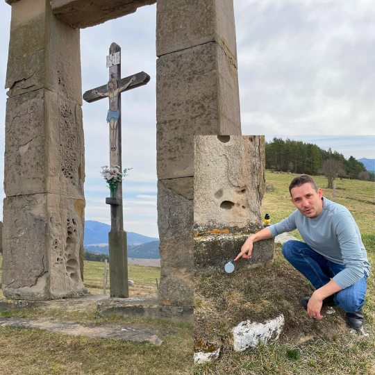
The gallows by Spišky Castle has a hidden jewel at the bottom, its a survey point! #civil3d #autocad #drone #civilengineering #topografia #survey #engineering #maps #mapping #gis #geomatics #photogrammetry #landsurveying #arquitectura #surveylife #3d #landsurvey #geodesy #architecture #construction #alberta #canada #surveying #surveyequipment #gnss #gps #geomatics #realsurveyors #engineer #landsurveyor (at Spišky Hrad) https://www.instagram.com/p/CqS9ACVqcAY/?igshid=NGJjMDIxMWI=
#civil3d#autocad#drone#civilengineering#topografia#survey#engineering#maps#mapping#gis#geomatics#photogrammetry#landsurveying#arquitectura#surveylife#3d#landsurvey#geodesy#architecture#construction#alberta#canada#surveying#surveyequipment#gnss#gps#realsurveyors#engineer#landsurveyor
0 notes