#john lort stokes
Explore tagged Tumblr posts
Visit Tumblr Blog
Explore Tumblr blogs with no restrictions, modern design and the best experience.
Last Seen Tumblr Blogs


Fun Fact
Tumblr has been providing a Korean-language service since 2013.
Text
South of Mount Barker (WA) in the 1830s, John Lort Stokes
met a party of natives engaged in burning the bush, which they do in sections every year. The dexterity with which they manage so proverbially a dangerous agent as fire is indeed astonishing. Those to whom this duty is especially entrusted, and who guide or stop the running flame, are armed with large green boughs, with which, if it moves in the wrong direction, they beat it out . . . I can conceive no finer subject for a picture than a party of these swarthy beings engaged in kindling, moderating, and directing the destructive element, which under their care seems almost to change its nature, acquiring, as it were, complete docility, instead of the ungovernable fury we are accustomed to ascribe to it.⁵
Such skills are for docile fire only. They are largely useless against today's infernos.
5. Nov 1840. John Lort Stokes, Discoveries in Australia, vol. 2, Libraries Board of South Australia, Adelaide, [1846] 1969, p. 228.
"Country: Future Fire, Future Farming" - Bill Gammage and Bruce Pascoe
#book quotes#country#bill gammage#bruce pascoe#nonfiction#mount barker#western australia#australia#30s#1830s#19th century#john lort stokes#indigenous australians#aboriginal australian#fire#burning#land management#kindling#moderation#direction#docile#inferno
0 notes
Text


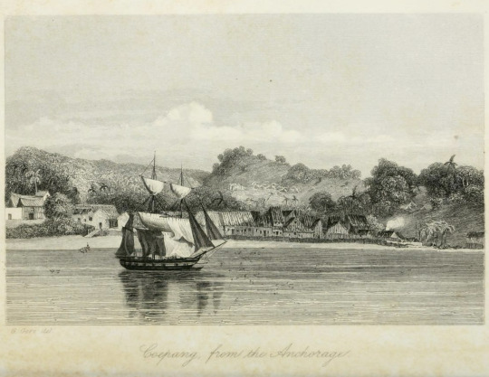

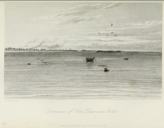

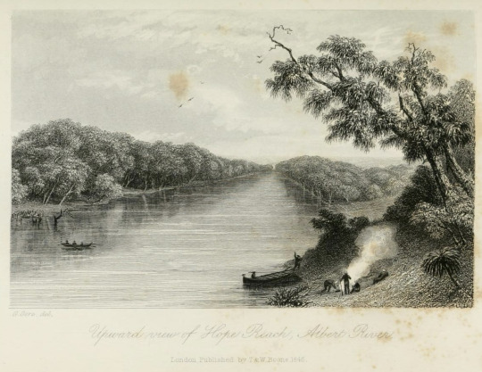

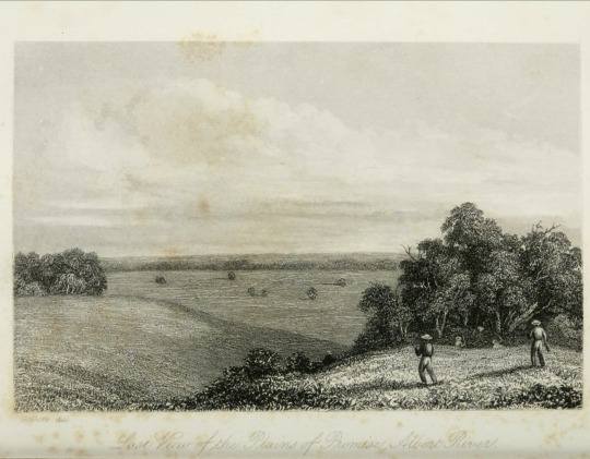
G. Gore del. / Graham Gore drew (it) A compilation [1/?]
engravings, based on original sketches (c. 1841) in: John Lort Stokes' Discoveries in Australia (vol. 1 / vol. 2, 1846)
I cannot allow these volumes to go before the public, without expressing my thanks to the following gentlemen for assistance, afforded to me in the course of the composition of this work: [...] to Lieutenants [Graham] Gore and [Lewis Roper] Fitzmaurice, for many of the sketches which illustrate the work [...]
1-2: South branch of the Albert River [in the Gulf of Carpentaria, Australia] / North West part of Magnetical Island [Yunbenun (Magnetic Island), Australia)]
3-4: Killing an Alligator, Victoria River [in the Joseph Bonaparte Gulf, Australia] / Coepang [Kupang, Indonesia], from the Anchorage
5-6: Passing between Bald Head & Vancouver Reefs [in Mammang-Koort (King George Sound), Australia] / Entrance of Van Diemen's Inlet [in the Gulf of Carpentaria, Australia]
7-8: Burial Reach, Flinders River / Upward view of Hope Reach, Albert River [in the Gulf of Carpentaria, Australia]
9-10: First View of the Plains of Promise, Albert River [in the Gulf of Carpentaria, Australia] / Last View of the Plains of Promise, Albert River
#Graham Gore#Franklin Expedition#Age of Sail#Polar Expedition#The Terror#AMC The Terror#(.history | .franklin expedition)#(.person | .graham gore)#(.person | .john lort stokes)#[[I'm bewitched by his art nerd energy]]
47 notes
·
View notes
Text


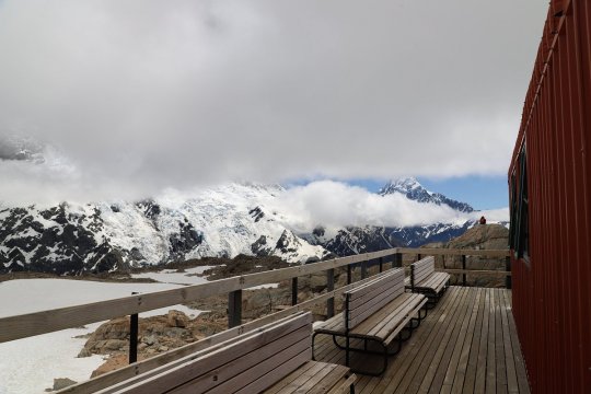


Гора Кука (Аораки) - наивысшая точка Новой Зеландии, высота которой составляет 3754 метра над уровнем моря, расположена в западной части Южного острова, в новозеландских Южных Альпах. Гора состоит из трёх пиков - самый низкий из них имеет высоту 3593 метра над уровнем моря, средний - 3717 метров и самый высокий - 3754 метра. Гора Кука сложена из кристаллических пород, имеет форму седла с крутыми склонами, а её вершина покрыта вечными снегами и ледниками. Вдоль восточного фланга горы спускается знаменитый ледник Тасмана - крупнейший ледник в Новой Зеландии, протяжённостью 29 километров и площадью 156,5 квадратных километров. Нижняя часть горных склонов покрыта уникальными дождевыми лесами умеренного климата и живописными альпийскими лугами, в которых произрастают эндемичные виды растений и редкие виды животных, встречающиеся только в Новой Зеландии.
Для маори, коренного населения Новой Зеландии, Аораки является священно�� горой, на языке племени Нгай Таху название горы означает "большое белое облако". Английское название Mount Cook (Гора Кука) дал горе в 1851 году капитан Джон Лорт Стокс в честь знаменитого мореплавателя Джеймса Кука. С момента открытия горы европейцами, её вершина постоянно манит альпинистов со всего мира. Несмотря на то, что Аораки - далеко не самая высокая гора на планете, она является технически очень сложной для восхождения. Огромную опасность для альпинистов представляют резкая смена погоды, сильные снегопады, высокий уровень обледенения скал, большие трещины ледников и высокая вероятность внезапного схода лавин. Только с начала XX века при восхождении на гору Кука погибло около 80 альпинистов, что делает её самым смертоносным пиком в Новой Зеландии. Не даром в легендарной эпопее Джона Толкина "Хоббит, или Туда и обратно", "Властелин колец" и "Сильмариллион" гора Кука стала прототипом пика Карадрас - одного из высочайших пиков Мглистых гор в Средиземье. Именно под Карадрасом был построен великий город гномов Казад-Дум
В 1953 году на территории вокруг горы Кука был создан Национальный парк Маунт-Кук, в который входят 19 горных пиков высотой более 3000 метров над уровнем моря и 8 (из 12) крупнейших ледников в Новой Зеландии. Парк является частью района Те-Вахипунаму, внесенного в список Всемирного наследия ЮНЕСКО за выдающуюся природную ценность. Помимо занятий альпинизмом (восхождение на вершину разрешено только опытным альпинистам в сопровождении горных проводников), посетители парка могут заняться скалолазанием, трекингом, горным велосипедом, охотой и насладиться невероятным зрелищем самого "звёздного" ночного неба на Земле. Во время прогулок по горным тропам можно увидеть попугая кеа - единственного в мире попугая, эндемика Новой Зеландии, обитающего на высоте 1500 метров над уровнем моря и выше.
Mount Cook (Aoraki) is the highest point in New Zealand, with an altitude of 3,754 meters above sea level, located in the western part of the South Island, in the New Zealand Southern Alps. The mountain consists of three peaks - the lowest of which is 3,593 meters above sea level, the middle one is 3,717 meters, and the highest is 3,754 meters. Mount Cook is composed of crystalline rocks, has the shape of a saddle with steep slopes, and its summit is covered with eternal snow and glaciers. Along the eastern flank of the mountain descends the famous Tasman Glacier - the largest glacier in New Zealand, with a length of 29 kilometers and an area of 156.5 square kilometers. The lower part of the mountain slopes is covered with unique temperate rainforests and picturesque alpine meadows, in which endemic species of plants and rare species of animals grow, found only in New Zealand.
For the Maori, the indigenous people of New Zealand, Aoraki is a sacred mountain; in the language of the Ngai Tahu tribe, the mountain's name means "large white cloud". The English name Mount Cook was given to the mountain in 1851 by Captain John Lort Stokes in honor of the famous navigator James Cook. Since the discovery of the mountain by Europeans, its summit has constantly attracted climbers from all over the world. Despite the fact that Aoraki is far from the highest mountain on the planet, it is technically very difficult to climb. Extreme weather changes, heavy snowfalls, high levels of icing on the rocks, large glacier cracks and a high probability of sudden avalanches pose a huge danger to climbers. Since the beginning of the 20th century alone, about 80 climbers have died while climbing Mount Cook, making it the deadliest peak in New Zealand. It is not for nothing that in the legendary epics of John Tolkien "The Hobbit, or There and Back Again", "The Lord of the Rings" and "The Silmarillion" Mount Cook became the prototype of the peak of Caradhras - one of the highest peaks of the Misty Mountains in Middle-earth. It was under Caradhras that the great city of the dwarves Khazad-dum was built.
In 1953, Mount Cook National Park was created on the territory around Mount Cook, which includes 19 mountain peaks over 3,000 meters above sea level and 8 (out of 12) of the largest glaciers in New Zealand. The park is part of the Te Wahipounamu area, listed as a UNESCO World Heritage Site for its outstanding natural value. In addition to mountaineering (climbing to the summit is only permitted for experienced climbers accompanied by mountain guides), visitors to the park can go rock climbing, trekking, mountain biking, hunting and enjoy the incredible spectacle of the most "starry" night sky on Earth. While walking along the mountain trails, you can see the kea parrot - the only parrot in the world, endemic to New Zealand, living at an altitude of 1,500 meters above sea level and higher.
Источник://shark-er.livejournal.com/121080.html,/tury.ru/sight/id/ 14721-gora-kuka-aoraki-14721,/www.tripadvisor.ru/Attraction_ Review-g658483-d4080009-Reviews-Aoraki_Mt_Cook- Mt_Cook _Village_Aoraki_Mount_Cook_National_Park_Te_Wahipounamu_Mac.html,/www.nik-m.com/regiony/kenterberi/aoraki-maunt-kuk-samaya-vysokaya-gora-novozelandskikh-ostrovov/,//t.me/ borderlesstravel.
#New Zealand#nature#national park#Mount Cook#mountains#Aoraki#lake#landscape photography#trees and forest#river#bridge#glaciers#blue sky#nature aesthetic#travel#wonderful#nature video#nature photography#Новая Зеландия#природа#Пейзаж#национальный парк#Маунт-Кук#Гора Кука#Аораки#горы#ледник#лес#озеро#река
293 notes
·
View notes
Text
I’m reading up on the real Lt. Graham Gore and found something that Captain John Lort Stokes (Gore joined his crew in Australia, 1840) wrote in his memoir

And oh-
Oh my god
#he joined the franklin expedition to get his (well deserved) promotion#only to die before the remaining crew walked out#on a more positive note#captain stokes’ ship was hms beagle#yes gore served on the same ship darwin used for his research#ngl that��s kinda cool#graham gore#franklin expedition#erebus#arctic exploration#northwest passage
41 notes
·
View notes
Text
Friday 18th October 2024
The first British person to spot what we now call Darwin was Lieutenant John Lort Stokes on HMS Beagle in 1839 but it wasn't until 1869 when a small settlement was established here and initially became known as Palmerston after Lord Palmerston the then Prime Minister and in 1911 the town was renamed Darwin. A port was soon established to supply the settlement but in 1897 a cyclone destroyed the whole lot; a cycle to repeat itself in 1974 when Cyclone Tracy flattened the entire town again killing 68 souls. Between Cyclones of course was a small conflict called WW2 which found Darwin a quite attractive target to the Japanese who successfully carried out a huge number of bombing raids, 64 in all. The mastermind Japanese commander who attacked Pearl Harbour then turned his attention to Darwin. American bases were established here and I'm sure over the next fews days we shall investigate these further.
Now affectionately referred to as 'The Top End' Darwin offers the tourist a great deal of interest.
The day started with a shortish run along the footpaths adjoining the Esplanade; early enough for it not to be too hot. Just as well, because the heat is on and it was promised to feel like 38 degrees.
Whilst still bearable we walked along the Esplanade passing the war memorials and down to where we first came ashore from our cruise in 2016. Memories were jogged and furthering these we thought we might catch a hop on hop off (hoho) to the Art Gallery. It was then we found that instead of paying £24 each for the hoho, we could catch a number 4 bus which was totally free!! Free entry to the Museum and Art Gallery as well, so perfect day all round! Now you know how it is when you ask for some travel advice from a bloke at a bus stop, any bus stop anywhere in the world, you ought to just know this is probably the one person in the universe that you shouldn't have freely opened yourself up to. I mean he looked innocent enough! We heard his travel plans, how much he was paying for his accommodation, about his brothers and so it went on. He got particularly exercised when talking about kangaroos. Part of the problem was that most words were expletives; if we could have cut those out the conversation could have been a fraction of the length. Then the bus came we made our goodbyes but he jumped on and sat next to us and enriched us with further insights. During the fairly short journey the driver chose to share his favourite album over the bus speaker system at several decibels! When he turned corners with his indicators going, we had a disco you could charge for. The benefit in all this was we struggled to hear what our new pal was saying! We reached the Art Gallery and it appeared he was going further. Clearly not an art lover.
We have been to this gallery before and it is predominantly exhibiting indigenous art, but it does have on display the pride of place work of a local taxidermist in the form of Sweetheart, a 16ft 10in crocodile! Sweetheart had not been very nice to a local community so it was decided to send a team of suicidal experts to capture and rehabilitate said 50-80 year old reptile. Sadly the operation did not go well for Sweetheart, and he died in the process, but lives on in his stuffed new attire. When the taxidermist did what taxidermist have to do, they found all manner of items within such as a sheep, various engine parts and bits of boats. The last time we visited this place, there was an excellent exhibition of pictures and reminiscentcies of the 1974 cyclone. It was closed today for refurbishment, but there was a powerful film being shown of the after effects of the storm. People's lives were completely shattered; destroyed. There was nothing left and everything needed rebuilding; property, lives, and way of life. But through it all, the people interviewed had nothing but praise for the help they received from friends, government and charities.
Bus back, no mate on board and unmolested we spilled into Coles for some further provisions. We ended the day on our lovely balcony, the sun casting its long beams shimmering across the sea whilst we sipped a chilled SB. Great day.
And on queue, as the sun disappeared completely, its work done for the day, a thousand birds incognito heralded the event yet again as though an orchestra under the control of a batton, their cheerfulness and zest filling their environment with song. Then, suddenly, without warning, all was quiet again until dawn.


3 notes
·
View notes
Note
This might be totally out of the blue and maybe not up your alley but do you have anything on Graham Gore? 👉👈
I do! (I helped write the Franklin Wiki thing on him because, your honor, I do love him very much.) I wish I knew more, but I haven’t dedicated as much time to researching him as I’d like. ;u;
William Battersby (yes, THAT William Battersby; RIP) did a really nice write-up about Gore in 2009, showing that he was definitely looking into Gore’s background. You can also cross-reference quite a bit--as well as learn about a really wild journey--through the volumes of John Lort Stokes and his time researching in Australia. The Stokes account is also the source of the story about Graham almost blowing up while hunting cockatoos, and it’s framed hilariously. Here’s the official Australian entry on Graham’s oil painting of Burial Reach (with fun zoom features!). But some of my absolute favorite stuff is Richard Lamb’s two-part feature on the history of the Gore family, which includes short entries on Graham’s father, older brother, and himself. It also marked the first time I’ve seen Graham’s name on a headstone!
21 notes
·
View notes
Video
Mitre Peak. New Zealand. by Bernard Spragg. NZ Via Flickr: The mountain was named by Captain John Lort Stokes of HMS Acheron, who found its shape reminiscent of the mitre headwear of Christian bishops. The Māori name for the peak is Rahotu. Mitre Peak is close to the shore of Milford Sound, in the Fiordland National Park in the southwestern South Island. It rises to 5,560 feet (1,690 m) with almost sheer drops to the water. The peak is actually a closely grouped set of five peaks, although from most easily accessible viewpoints, it appears as a single point. Milford Sound is part of Te Wahipounamu, a World Heritage Site as declared by UNESCO.
0 notes
Photo

On this day in 1885 Admiral John Lort Stokes passes away at Scotchwell. He was a highly accomplished navigator and hydrographer with many of his charts of Northern Australia, New Zealand and England still being used today. Stokes wharf in Darwin is named in his honour. https://www.instagram.com/p/ByizUinJpDW/?igshid=1ffxb5dy1634b
0 notes
Text
Image taken from page 440 of 'Discoveries in Australia; with an account of the coasts and rivers explored and surveyed during the voyage of H.M.S. Beagle, in the years 1837-43. ... Also a narrative of Capt. Owen Stanley's visits to the Islands in the Araf
Image taken from: Title: "Discoveries in Australia; with an account of the coasts and rivers explored and surveyed during the voyage of H.M.S. Beagle, in the years 1837-43. ... Also a narrative of Capt. Owen Stanley's visits to the Islands in the Arafūra Sea" Author: STOKES, John Lort. Shelfmark: "British Library HMNTS 1304.k.2-3." Volume: 01 Page: 440 Place of Publishing: London Date of Publishing: 1846 Issuance: monographic Identifier: 003512490 Explore: Find this item in the British Library catalogue, 'Explore'. Open the page in the British Library's itemViewer (page image 440) Download the PDF for this book Image found on book scan 440 (NB not a pagenumber)Download the OCR-derived text for this volume: (plain text) or (json) Click here to see all the illustrations in this book and click here to browse other illustrations published in books in the same year. Order a higher quality version from here. from BLPromptBot http://ift.tt/2n4voga
0 notes
Text
Shrewsbury + News from our partners: Museum in Australia would like you to check your attic for HMS Beagle images
News from our partners University Centre Shrewsbury
The Museum and Art Gallery of the Northern Territory (MAGNT), the premier cultural organisation in Australia’s Northern Territory, is asking Shropshire people for help. The Museum hopes that someone in Shropshire, the birthplace of Charles Darwin, will have a depiction of the HMS Beagle’s anchors.
Darwin spent five years travelling around the world on the HMS Beagle – an education that led to one of science’s highest achievements, The Origin of Species.
This past October (2108), a team of Australian explorers found one of the HMS Beagle’s two anchors in a rocky hollow beneath 10 metres of murky brown water at the bottom of the mighty Victoria River in the north of Australia. Once recovered, the anchor will become a prized artefact on display in Darwin as one of the only relics remaining of one of the best-known vessels in maritime history.
Professor Tim Jenkins, Head of Arts & Humanities, University Centre Shrewsbury, said:-
“The Beagle is the little ship that could – a smaller workhorse vessel manned by some the best sailors of the day. Not only was she instrumental in one of science’s greatest breakthroughs, but also the surveying of large sections of unchartered Australian coast.”
In their research, the curators have been able to find only one image of the Beagle that shows the anchors – a drawing from one of Darwin’s books that is under license. They hope there is another in existence that could be shared with them.
Two previous expeditions had tried and failed to find the anchors.
Ben Wall, skipper of the successful team, said:-
“It’s a savage river. In addition to crocodiles, bull sharks and deadly jellyfish, the crew had to face a 60-knot squall. You can only imagine what the blokes on the Beagle went through. They would’ve had a bloody hard time.”
The anchors were lost on the Beagle’s third and final journey (1837-1843), when Darwin’s former shipmates John Wickham and John Lort Stokes were surveying the coast of Australia. During the trip, the seamen gave many Australian places on the coast English names, such as the (Queen) Victoria River and Port Darwin (which later lent its name to the city of Darwin), whose fine-grained sandstone reminded them of their friend and his “geologising.”
The Beagle crew set out to survey the length of the dangerous Vic but after miserable conditions – freak storms, whirlpools, those pecky crocodiles, mosquitoes, dysentery – they decided to return to the relative calm of the ocean. When they tried to make the turn, the ship’s anchors were stuck on the river bottom.
The crew feverishly tried to raise the precious anchors – nearly splitting the boat in half in the process – to no avail. Noting the loss in his diary, Lort Stokes wrote: “circumstances suggest the appropriate name of Holdfast Reach for this locality.”
“Perhaps in some future generations, when this part of the world has undergone the changes that seem destined for it,” he further wrote, “the archaeologist of the Victoria River may in vain puzzle his wits with speculation concerning the Beagle’s anchors.”
Paul Clark, Senior Curator, Maritime Archaeology and History, MAGNT, said:-
“Not only was Lort Stoke a superb seaman, but prescient as well. Here we are, 180 years after the loss of the Beagle’s anchors, in search of more information about them.”
Paul Kirkbright, Deputy Provost of the University Centre of Shrewsbury, met Clark when he recently visited Darwin and the Northern Territories on invite from the University of Darwin:-
“The museum asked if the University could help them try to find more documentation on the anchors by asking Shropshire people to check their attics for images that may be of use. You never know what might turn up.”
In 1845, after its third journey, the HMS Beagle was retired as a coastguard watch vessel in the River Roach where it was moored until sold as scrap in 1870 to a local farmer.
Remaining timbers from the lower hull were discovered near the mooring place, as well as three of the four Beagle’s last set of anchors.
Should you have documentation of the HMS Beagle’s anchors, please contact us at: [email protected].
The post News from our partners: Museum in Australia would like you to check your attic for HMS Beagle images appeared first on Shropshire Council Newsroom.
http://bit.ly/2KNOUi8
0 notes
Text
[...] Something whizzed past my ear, deafening and stupefying me for a moment—the next I saw my much-valued friend [Graham] Gore stretched at his length in the bottom of the boat, and I perceived at a glance the danger we had incurred and providentially escaped. His fowling piece had burst in his hand, and flown away in fragments, leaving only a small portion of the barrel at my feet. [...] Mr. Gore's hand was dreadfully lacerated; but no bones were broken; and on recovering from his swoon, the first words he uttered were: "Killed the bird!"—an expression truly characteristic of a sportsman [...].
- Captain John Lort Stokes of the HMS Beagle: Discoveries in Australia (1846, vol. 2)
aka Graham Gore has no right being this funny (if anyone wants to draw this tho)
#Graham Gore#Franklin Expedition#Polar Exploration#Age of Sail#The Terror#AMC The Terror#(.history | .franklin expedition)#(.person | .graham gore)#(.person | .john lort stokes)#[[Not show related but I feel like y'all are the target audience]]#[[Seriously how do you tag this?]]#[[I totally did not fall down a research rabbit hole]]#[[Nope]]#[[Real Gore and Fitzjames probably got on like a house on fire]]#[[They'd match each other's crazy]]
16 notes
·
View notes
Text
There was only one drawback to the pleasure I experienced on arriving in England—namely, that Lieutenant G.[raham] Gore did not obtain his promotion, but was compelled to seek it by a second voyage to the N.[orth] Pole. [Gore has been to the Arctic for the first time during Sir George's Back expedition in 1836/37.]
- Captain John Lort Stokes of the HMS Beagle: Discoveries in Australia (1846, vol. 2)
[...] I am still in suspense whether or not I am to go on the Arctic Expedition. [...] But I imagine going would probably assist me in getting advancement in the service; and in the usual routine there is but a poor prospect. [...]
- John Irving to Catherine Irving, née Caddell (February 28, 1845)
Gore 🤝 Irving, apparently
"I really don't wanna be here but I'm begging you on my knees for this sweet promotion."
#Graham Gore#John Irving#Franklin Expedition#Age of Sail#Polar Expedition#The Terror#AMC The Terror#(.history | .franklin expedition)#(.person | .graham gore)#(.person | .john irving)#(.person | .john lort stokes)#[[A promotion to die for one might say]]#[[Kinda sad that the wardroom officers were either Fitzjames' nepobabies and nepobabies by proxy (Le Vesconte Fairholme Hodgson)]]#[[Or just some guys who felt like they needed to join in for one reason or another (Gore Little Irving)]]#[[Okay to be fair Irving is technically also a Fitz nepobaby by proxy because he was probably there on Hodgson's recommendation but]]#[[And then there is Little who most likely got dragged into this mess by Franklin himself]]#[[Anyway]]
8 notes
·
View notes