#desert geology
Explore tagged Tumblr posts
Visit Tumblr Blog
Explore Tumblr blogs with no restrictions, modern design and the best experience.
Last Seen Tumblr Blogs


Fun Fact
Celebrities use Tumblr as well.
Text

Monument Valley
239 notes
·
View notes
Text
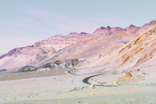


painted peaks; death valley, california
instagram - twitter - website
#photographers on tumblr#landscape#nature#aesthetic#pastel#desert#road#texture#mountains#geology#dreamscape#travel#death valley#california#national parks#original photographers#artists on tumblr#art#outdoors#leah berman
9K notes
·
View notes
Text
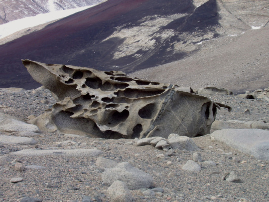
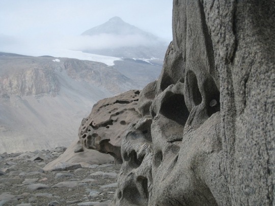

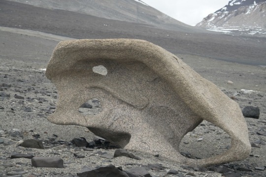
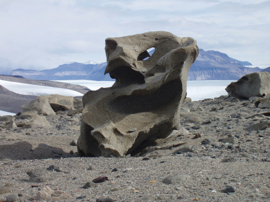
The aeolian processes of katabatic winds in Antarctica’s McMurdo Dry Valleys shape boulders into surreal formations
#ultimate life goal is to visit here#antarctica#mcmurdo station#mcmurdo dry valleys#desert#geomorphology#geology#rocks#aeolian processes#aeolian landform#earth science
5K notes
·
View notes
Text


See that white layer in this hillside? That's an extremely important white layer. 680,000 years ago (give or take), a large volcanic system in what is now Wyoming erupted catastrophically, spewing ash and debris across the North American continent. You might have heard of it, it's called Yellowstone Caldera. You may notice that these pictures in no way resemble the verdant forests of the Rocky Mountains and that is because they are from Death Valley, California, located more than 620 miles (1000 km) away from the Yellowstone Caldera!

But... it gets cooler.
The hills this ash layer is exposed in, the Kit Fox Hills, have been uplifted. The mudstone and sediments here are ancient valley fill, meaning that they used to be the bottom of the valley and are now about 400'/120 m above the current valley floor. This is the action of the Northern Death Valley fault zone, one of California's longest active faults. In this area, that fault has some excellent outcrops as seen below.


Next door to Death Valley to the west is Panamint Valley. It's not quite as big or dramatic as Death Valley but it has many of the same sorts of geologic features which have formed over a shorter geologic timeframe, interestingly. The faults in Panamint Valley just move faster than those in Death Valley so things are a little more youthful over there. In the middle of Panamint Valley, we see this same Yellowstone ash layer but with a caveat - instead of a mere 400 feet, in Panamint Valley that ash is more than 500 feet above the valley floor! That suggests that the valley subsidence of Panamint Valley is about 20% faster than Death Valley. The true story is more complex than that, but it's good as a reference point. Let's see what that looks like.

It's hard to see in this aerial imagery, but near the top of this steep escarpment is that same volcanic ash layer. It's a bit thicker here because this big pile of material I've outlined is an ancient delta. Panamint and Death Valleys have repeatedly hosted large lakes during cooler and wetter times. This huge delta deposit is over 1.2 million years old at the base, and about 600,000 years old at the top (above the Yellowstone ash). As the Panamint Mountains (background) rose and the valley subsided, huge amounts of eroded rock and gravel were dumped on this delta. So what you're looking at is a 1 million year-long record of the floor of Panamint Valley! How cool is that?
#geology#adventures#bettergeology#rocks#delta#death valley#california desert#eastern california#california#southern california#mojave desert#death valley national park#death valley geology#geology is cool
740 notes
·
View notes
Text

Javelina Rocks, an example of striped mylonitic gneiss, Saguaro National Park, Arizona.
212 notes
·
View notes
Text

Joshua Tree, California
#cmt photography#original photographers#photographers on tumblr#travel photography#landscape photography#moody#joshua tree#national parks#california#usa#desert#high desert#geology#bouldering
126 notes
·
View notes
Text
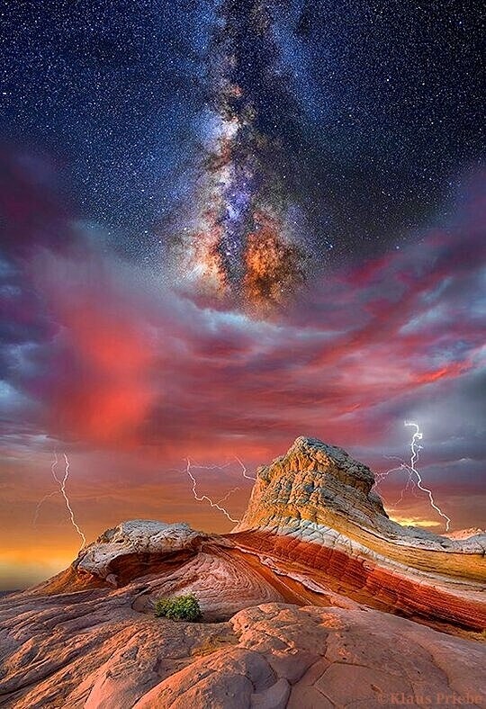
📷 Klaus Priebe
#photography#nature#Milky Way#stars#space#desert#clouds#landscape#landscapes#lightning#sunset#mountains#geology#natural history#astronomy#sky#sunrise#aesthetic#art#beauty-funny-trippy#Klaus Priebe
507 notes
·
View notes
Photo

Alstrom Point, Lake Powell, Glen Canyon National Recreation Area, Page, Arizona
Photography by Ron Niebrugge
#travel#Arizona#Lake Powell#rock formations#geology#desert tones#light and shadow#photography#landscape photography
334 notes
·
View notes
Text

road and faults,
Rainbow Basin Natural Area, north of Barstow, California.
#california#rainbow basin natural area#landscape#photographers on tumblr#original photography#desert#monochromatic#geology#erosion#park#frank foster
37 notes
·
View notes
Text

Nevada Afternoon
174 notes
·
View notes
Text

#IFTTT#Flickr#“mittenbuttes”#mittens#monumentvalley#utah#arizona#usa#buttes#coloradoplateau#navajotribalpark#sunrise#dawn#morning#sunbeam#crepuscularray#sandstone#siltstone#geology#rockformation#tourism#scenic#spectacular#colourful#colorful#navajo#desert
85 notes
·
View notes
Text
Oh My God?????
Libyan Desert Glass??????
What???? This is so cool??? Why did no one tell me about this before???????
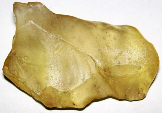

It's glass was formed when a meteor hit some sand in Egypt like 29 million years ago and it heated up to absurd temperatures and then quickly cooled?????
That's so fun?????? I love this??????
242 notes
·
View notes
Text

Arid limestone hills at the southern end of the Mule Mountains, Cochise County, Arizona.
154 notes
·
View notes
Text

92 notes
·
View notes
Text

Merrick's Butte, Monument Valley, Brad Randleman, 2011..
#Merrick's Butte#Monument Valley#Brad Randleman#2011#BW#black and white#geology#butte#photography#desert#outdoors
27 notes
·
View notes
Text


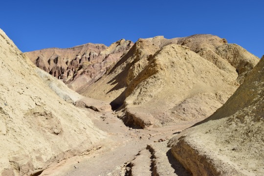

Mementos from the Zabriskie badlands, Death Valley NP, California
What happened here? Well, I’ll tell you:
Death Valley is a huge tectonic basin. That is, it was formed by plate tectonics rather than erosion from water. It is not the first valley here, however. Valleys and basins are recorded in Death Valley’s rock record several times in the last ~25 million or so years, culminating in the current huge valley which is the deepest point below sea level in the western hemisphere. At Golden Canyon, a popular easy hiking spot, the rocks record previous editions of Death Valley. Called the Furnace Creek Formation, these soft yellow-brown rocks are made of lake sediments that were laid down when an older, smaller basin existed about 3-5 million years ago. In places, minerals in these rocks mark times when that lake dried up, recording a climate history of the area!
Less than a million years after this rock sequence was laid down, the very active faults on either side of it tore this basin apart. The rocks were folded, faulted, tilted, and uplifted to their current position by the Northern Death Valley fault and the Black Mountains faults. Slowly, the soft rocks eroded down to reveal their story, now visited by about one million people per year.
#geology#photography#adventures#bettergeology#california#death valley#love the desert#desert#Death Valley geology#Death Valley National Park#rocks#geomorphology#Pliocene
20 notes
·
View notes