#bluff utah
Explore tagged Tumblr posts
Text

Petroglyphs on the San Juan River Near Bluff, Utah
Petroglyphs of deer and mountain sheep on the San Juan River near Bluff Utah in Navajo Country
UNM CSWR Karl Kernberger Pictorial Collection
New Mexico's Digital Collections
#petroglyphs#sheep#deer#mountain sheep#san juan river#bluff utah#navajo country#new mexico's digital collections#unm cswr karl kernberger pictorial collection
5 notes
·
View notes
Text


Bluff, Utah, USA
Michael
6 notes
·
View notes
Text

Water Wheel - October 2023 While at Goosenecks State Park we took a very short day trip down to Bluff, Utah, which was an early Mormon settlement. The story of those early settlers’ trek across the mountains is very interesting. There are a lot of cabins and other historical artifacts, but what was most interesting to me was a replica of one of the many water wheels which those early settlers built on the San Juan River. Unfortunately, the San Juan floods regularly and some of those floods are very destructive. After having their water wheels swept downstream time after time, they built a canal from higher upstream to divert the water. That however kept filling up with sand and eventually they had to abandon attempts to farm the land around Bluff and turn instead to dry-land ranching. This is a neat image on its own, but the barrels filled with water that dump into the aqueduct are fascinating to watch. MWM
2 notes
·
View notes
Text

#IFTTT#Flickr#firefallphotographycom#jstamer#utah#2024#bluff#therincon#craterbutte#drybayou#dronedjiair2s#aerial#view
0 notes
Text
Another Wash Hike - Valley of the Gods, UT

We are spending one last day in this area, it has really quieted down since the weekend. We are the only people left in the area we are parked in - just lovely! We took a little walk up another wash in the area - it has been so nice to get some hiking in. We missed our summer and fall hiking while we were in Europe!
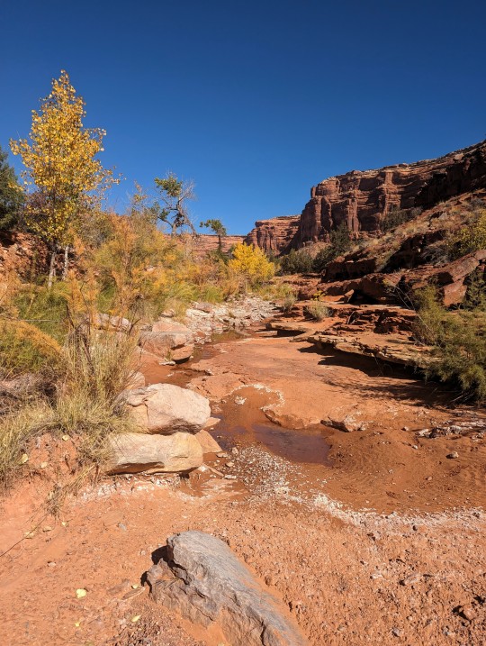
Surprisingly, we found a little spring gurgling up in the wash.
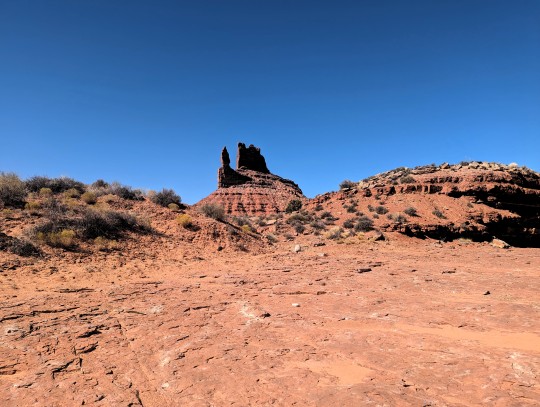
Great view of one of the many massive formations along Valley of the Gods road.
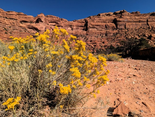
Gorgeous red canyon walls as we made our way up the wash.
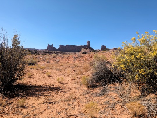
Awesome views as we made our way back to our campsite.
We had a great time visiting this area, there is just something magical about the places we have been in this part of Utah. Our last evening here did not disappoint us:
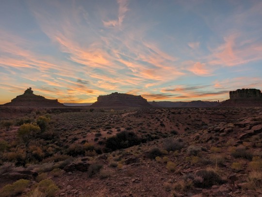


So long, Utah, until we meet again.....
0 notes
Text


Obligatory eclipse post, feat. Me, learning how to use the camera day of.
[image descriptions: "a time lapse of the annular eclipse that happened today, October 14th 2023. Ending on the complete 'ring of fire'" end description]
#sparkyblahs#sparkypics#long post#these were taken in bluff utah#with a Canon t7#and a solar filter from spectrum telescope l#on a 300mm lens#I'm really happy with how it turned out overall#but i also learned a Lot
1 note
·
View note
Text
American Auto Trail-Trail of the Ancients Scenic Byway (Aneth to Bluff UT)
American Auto Trail-Trail of the Ancients Scenic Byway (Aneth to Bluff UT) https://youtu.be/L_AEDZhlPRs This American auto trail explores the route of the Trail of the Ancients Scenic Byway along the San Juan River in southeast Utah.

View On WordPress
#4K#american history#Aneth#Auto trail#Bluff#driving video#Montezuma#Navajo#Oil Exploration#road travel#San Juan River#slow travel#Trail of the Ancients#utah
0 notes
Text
Twin Rocks Café

View On WordPress
0 notes
Text

With the Twin Rocks in Bluff, Utah
0 notes
Text
Suddenly, Letters from Watson dumps us in the middle of the Great American Desert (part 1 of "On the Great Alkali Plain," 2/7/24). This is not anywhere I expected to be transported from London, and the contrast makes the Mountain West feel exotic for a minute.
The Great American Desert -- stretching from about Grand Island, Nebraska to the Sierras and pretty much the entire north-south length of the U.S. -- had become a thing of legend since explorers' accounts in the 1820s. When Dad and I drove across it in 2022, we talked about how incredibly daunting it must have been for emigrants seeking their land of milk and honey on the Pacific coast.
The way we went, out I-80, Nebraska shifts from green to gray as it rises toward the Rockies. After a while, the wind picks up as you go uphill into Wyoming. There's a lot of Wyoming, and after Cheyenne and Laramie (both of which would be small towns in most states), it's very, very empty. When we finally started the descent toward Salt Lake City, and the little valleys beside the road turned green with running water, it was truly like entering paradise.
Of course, in 1847, Salt Lake City was just barely being settled, as Brigham Young led his Latter Day Saints west from Council Bluffs, and its location wasn't part of the U.S. yet.
The Mexican-American war had started the prior year, 1846, and was still going. Spring-summer of 1846 saw the Bear Flag Revolt in California, followed by the U.S. just annexing the state. Gold wouldn't be discovered at Sutter's Mill until 1849, so while emigration to California happened -- the Donner Party made their ill-fated trip in 1846-47 -- it wasn't anything like the scope of movement along the Oregon Trail.
As far as I can tell, "Sierra Blanco" is not a real place. There's a Sierra Blanca in New Mexico -- which would fit with all the specific landscape, plus White Sands National Park in New Mexico specifically has alkali flats. Last time I drove through New Mexico on I-40, in late 2018, it was delightfully desolate, so I can buy that in 1847, it seemed completely empty, with even the native peoples avoiding some stretches.
Why anyone would be crossing New Mexico is a mystery, since neither Arizona nor southern California were much settled by Americans. There was some sort of wagon route across New Mexico used by U.S. soldiers during the Mexican-American War, so if I'd expect anyone to be about, it'd be the U.S. Army.
Utah, now, is downright famous for its salt flat, but that's west of the site of Salt Lake City.
Regardless, parties screwing up their trip to the west by taking an imprudent shortcut or mistaking the route was definitely both a thing that happened and, thanks to the Donner Party, a trope. Our haggard and starving traveler sounds about right.
Then he reveals a Plucky Innocent Victorian Child.
That "pretty little girl of about five years of age" is the absolute ideal of Victorian childhood, being perfectly behaved, utterly imperturbable, determined to see the best in all things, sweet, trusting, and looking forward to being reunited with her mother in heaven.
This kind of child is why Louisa May Alcott was seen as innovative for writing Little Woman about girls who worked on their character flaws. (This is also the ideal the March girls were being aimed at. Polly in An Old-Fashioned Girl comes closer, but even Polly would have been upset about being hopelessly lost in the desert with no water.) Contrast this with the street urchins that Holmes employs in his investigation, who are good enough sorts but scrappy, resourceful, and street smart.
Ordinarily, a Victorian child who was utterly sweet and pious would be a cinnamon roll, literally too good, too pure for this world, and thus would die beautifully but tragically before long. Being lost in the desert seems ideal for this, but --
She turns to prayer, and since someone must survive in order for this scene to be relevant,
Yes, darn it, I am on the edge of my seat to know what happens. I'm also grateful that crossing the Great American Desert in 2022 was a quicker process. I've been reading Carey Williams' old-but-interesting California: The Great Exception, which has a lot to say about how 19th century isolation shaped California's economy and power structure, not always for good. But that's neither here nor there -- I don't think we're headed to California.
22 notes
·
View notes
Text


Bluff, Utah, USA
Michael
3 notes
·
View notes
Text


Bluff, Utah. 2019
#photo by sophie casoni#desert vibes#photography#medium format#on the road#retro aesthetic#artists on tumblr#photographers on tumblr#american southwest
8 notes
·
View notes
Text
35 notes
·
View notes
Text
WORDPLAY WEDNESDAY: MEMBER
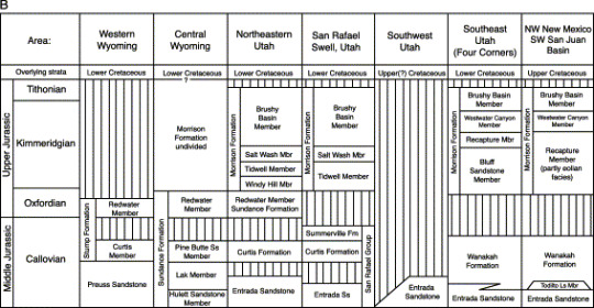
I use the word "member" a lot and no it's not in relationship to an exclusive group. Well, not really. A member is a lithologically distinct part of a formation. Members do not need to be mappable to the same scale as a formation but sometimes they are large enough to be.
The Morrison Formation has 11 members: the Bluff Sandstone,

Bluff Sandstone Type section near Bluff, Utah
Brushy Basin Member,

Brushy Basin, San Rafael Swell, Utah
Fiftymile Member, Jackpile Sandstone,

White Jackpile Sandstone, Jemez Mountains, New Mexico capped by Cretaceous Dakota Sandstone
Ralston Creek Member,
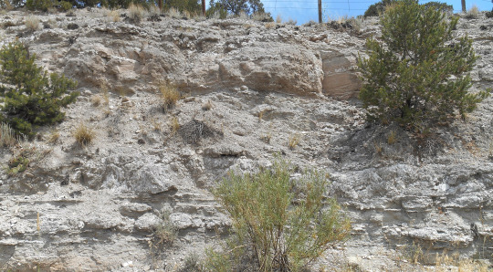
Ralston Creek Member, Fremont County, Colorado
Recapture Member, Salt Wash Member
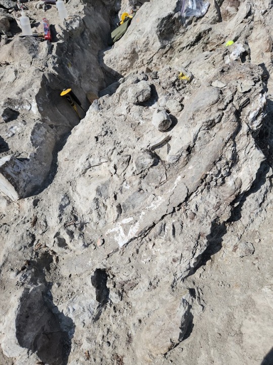
Salt Wash Member, Evil Tree Quarry, Colorado
Tidwell Member,
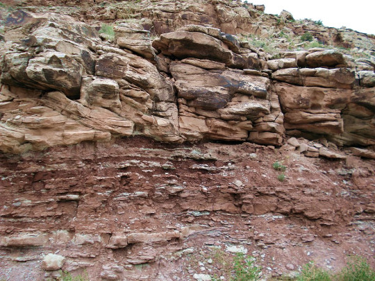
Red Tidwell Member muds capped by Salt Wash Member channel sandstones Cisco, Utah
Unkpapa Sandstone,

Unkpapa Sanstone, Black Hills, South Dakota
Westwater Canyon Member, and finally, Windy Hill Member

Windy Hill Member, Glendo Reservoir, Wyoming
So as you can see, there are similarities and differences between all of these members. To get an idea of how they are work together, here is a comparison through Wyoming, Utah and New Mexico.
12 notes
·
View notes
Text
Goosenecks & Natural Bridges - Bears Ears National Monument, UT

Everyone left this morning, so it is just Doug and I left at the campsite. We decided to do a little exploring and headed out to Goosenecks State Park and then on to Natural Bridges National Monument.

Impressive view from the rim at Goosenecks.

Look at the color of that water! It sure was a long way down to the river - definitely wanted to stay away from the edge.
After taking a short walk along the rim at Goosenecks, we drove over to Natural Bridges National Monument. We went on a nice loop hike - going from the parking area at Sipapu Bridge Viewpoint, down to Sipapu Bridge and over to Kachina Bridge, then up to the Kachina Bridge Viewpoint, and returning to the Sipapu Bridge Viewpoint parking area.

Looking down at Sipapu Bridge from the viewpoint.
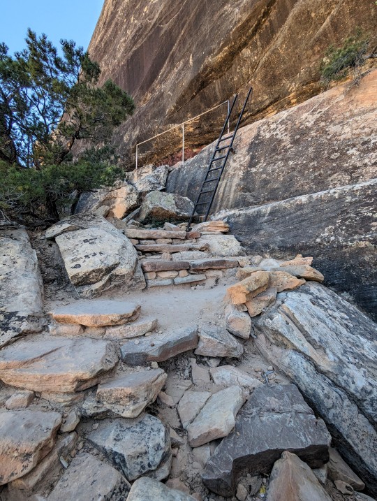
Making our way down to Sipapu Bridge - ladders, railings, and steps were involved. It was a pretty steep descent!

Another view of Sipapu Bridge, just before the final descent to its base.

Sipapu Bridge - almost to its base!

Beautiful view of Sipapu Bridge from underneath.
We continued down the wash toward Kachina Bridge. It was a lovely walk, plenty of canyon walls and a bit of sand to trek through.

Gorgeous striated canyon walls as we neared Kachina Bridge.

Kachina Bridge - just before we walked under it.
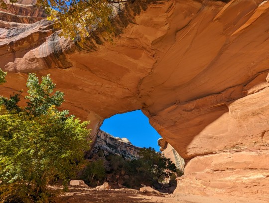
Looking back at Kachina Bridge - it is impressive!
Just a short walk from Kachina Bridge are some petroglyphs and ruins. It was a bit of a scramble to get up to them, but well worth the effort.
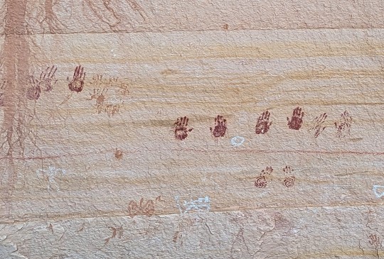

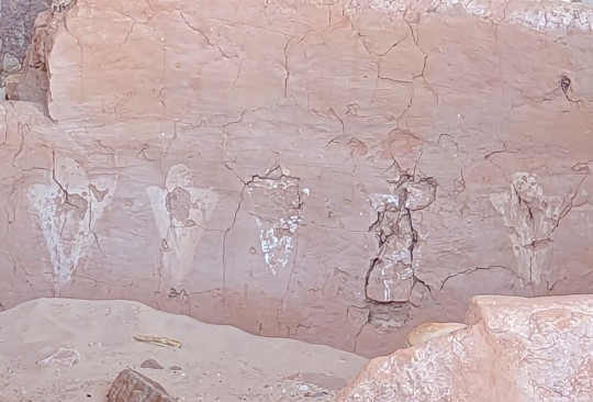

There were pamphlets near the petroglyphs that provided detailed information about the site. The park does not promote this area, but if you stumble upon it, you are more than welcome to check it out.
It was now time to climb up out of the canyon - it was a steep climb back out and the temperatures were a bit warm by the time we got to the top. Luckily, there were a couple of stops during the climb to rest and take photos!

Beautiful view of the fall colors in the wash, as we made our way to the top.

One last view of Kachina Bridge as we climbed out of the wash.
We made it to the Kachina Bridge Viewpoint, crossed the road, and followed the trail back to Sipapu Bridge Viewpoint and to our truck. Great hike and thrilled to actually visit Natural Bridges - a place I had never been to before. Bears Ears National Monument is full of treasures, glad that it has been preserved for all of us to experience.

The two peaks in the distance are the "Bears Ears" of Bears Ears National Monument.
#goosenecks state park#natural bridges national monument#utah hikes#bluff#bears ears national monument#utah
0 notes


