#archaeologists survey of india
Explore tagged Tumblr posts
Text
स्मारकों के स्वामित्व को लेकर भिड़े एएसआई और वक्फ बोर्ड, एएसआई ने जेपीसी को सौंपी ऐसे 120 स्मारकों की सूची
स्मारकों के स्वामित्व को लेकर भिड़े एएसआई और वक्फ बोर्ड, एएसआई ने जेपीसी को सौंपी ऐसे 120 स्मारकों की सूची #News #DelhiNews #DelhiUpdates #DelhiPolitics #DelhiEvents #DelhiLifestyle #DelhiBuzz #DelhiCulture #DelhiCommunity #DelhiActivism #DelhiEducation
Delhi News: एएसआई और वक्फ बोर्ड के बीच स्मारकों के स्वामित्व को लेकर विवाद छिड़ा है। वक्फ (संशोधन) विधेयक की जांच कर रही संसदीय समिति को भारतीय पुरातत्व सर्वेक��षण (एएसआई) ने शुक्रवार को 120 से अधिक स्मारकों की सूची पेश की। एएसआई ने कहा कि स्मारक उनके संरक्षण में हैं, लेकिन विभिन्न राज्य वक्फ बोर्ड स्मारकों पर अपना दावा करते हैं। विपक्षी सदस्यों ने एएसआई की दलील की आलोचना की कि मुस्लिम निकाय किसी…
#archaelogical survey of india#archaeogical survey of india#archaeological survey of india#archaeological survey of india (asi)#archaeological survey of india and the historical imagination#archaeological survey of india delhi#archaeological survey of india gives clarity on qutub minar#archaeological survey of india inspection in weaving factory#archaeologists survey of india#archeological survey of india#ASI#asi vs waqf board on tajmahal#delhi waqf board#India#JPC#land grab waqf board#list of 120 monuments#monuments#ownership#pm modi archaeological survey of india#shia waqf board#sunni waqf board#up waqf board survey#wakf board#waqf board#waqf board bill#waqf board chairman#waqf board controversy#waqf board land grab#waqf board latest controversy
0 notes
Text
Dr. K. K. Muhammed, the Indian archaeologist who served as the Regional Director of the Archaeological Survey of India. He was heavily involved in the excavations done at the site of Babri masjid, and he was the first to ask Muslims to hand over the Babri Masjid area to Hindus after finding evidence that the mosque was built on the remains of a Hindu temple.
Please listen to what he has to say about Hindus.
#KK Mohammed#ram mandir#hinduism#hindublr#sanatandharma#hindu culture#hindu temples#ayodhya#hindus#hindutva#hindu values#sanatan dharma#desiblr#desi tag#desi tumblr#archaeology#history
57 notes
·
View notes
Text
Discover the Hidden Marvel of Masroor Rock Cut Temple

As you venture beyond the bustling lanes of Mcleodganj and travel southwest, you’ll find yourself on a quieter road that leads to a hidden gem in Himachal Pradesh—the Masroor Rock Cut Temple. This temple complex may not be on every tourist’s radar, but it is an architectural wonder that deserves a spot on your travel itinerary.
For those who enjoy exploring offbeat locations, this site offers a captivating experience, often compared to the famed Angkor Wat of Cambodia due to its stunning rock-carved structure.
A Closer Look at the Masroor Rock Cut Temples

Located in the Kangra district, the Masroor Rock Cut Temples are a group of ancient Hindu shrines intricately carved from a single monolithic rock. This temple complex stands as the only example of Nagara-style architecture in North India, making it a rare site for those interested in both history and architecture.
The detailed carvings depict various Hindu deities, offering visitors a glimpse into India's rich religious and cultural past.

The temple complex faces the majestic Dhauladhar mountain range, providing a scenic backdrop. Although four entrances were originally planned, only one is fully completed, adding a sense of mystery to the site.
In front of the temple lies a sacred water reservoir, whose still waters beautifully reflect the temple structure, making it a dream location for photography enthusiasts. The serenity and architectural beauty of the Masroor Rock Cut Temple offer a peaceful escape from the more crowded tourist spots in Himachal Pradesh.
The History of the Temple

The history of the Masroor Rock Cut Temple is shrouded in mystery, with little known about its origins. However, it is widely believed that the temple complex was built in the early 8th century. Its hidden location likely kept it off the radar until 1913, when British officer Henry Shuttleworth stumbled upon the temple and reported it to archaeologists.

In 1915, the Archaeological Survey of India (ASI) conducted a survey, sparking archaeological studies and preservation efforts. While the temple complex remains largely intact, the weathering of time has left its mark, adding to the ancient allure of this remarkable site.
Myths and Legends: The Story of the Pandavas

According to local legend, the Masroor Rock Cut Temple is linked to the epic tale of the Mahabharata. It is said that the Pandavas—five brothers who were central characters in the Mahabharata—built the temple during their exile from their kingdom.

The water reservoir, which remains an iconic feature of the temple complex, was supposedly constructed for Draupadi, their wife, to provide a source of water during their stay. Whether you believe the legend or not, the temple’s mythical connection adds to its intrigue, making it an even more compelling destination for travellers fascinated by India’s rich mythology.
How to Get There
🚗 By Road: The nearest major town is Dharamshala, located 43 km from the temple. Travelers can easily take a bus to Dharamshala and then hire a private taxi for the remainder of the journey.
✈️ By Air: The closest airport is Kangra Airport, approximately 30 km from the temple. Taxis are readily available at the airport to take you directly to the site.
🚆 By Train: For those who prefer to travel by train, the nearest railway station is in Kangra, 53 km away. From there, taxis or other forms of transport can take you to the temple.
If you're planning to visit the Masroor Rock Cut Temple and you're traveling from abroad, applying for an Indian Visa can simplify the process. The Visa for India is available for citizens of over 160+ countries, allowing travelers to apply for a visa online from the comfort of their homes. The eVisa is perfect for short visits, typically issued for tourism. For those interested in discovering the cultural treasures of Himachal Pradesh, like the Masroor Rock Cut Temple, the tourist eVisa is the most suitable option.
The process to apply for the Indian Visa is simple and quick. You’ll need to fill out an Indian visa application form, upload your passport and a passport-sized photo, and pay the visa fee. In most cases, the eVisa is processed within 3 to 5 business days, though it is recommended to apply at least a week in advance of your trip. Once approved, your eVisa will be electronically linked to your passport, and you will receive a confirmation email. Upon arrival in India, all you need to do is present your passport at the airport.
What to Expect at Masroor Rock Cut Temple

Whether you’re a culture enthusiast, a photographer, or simply someone looking for a unique destination away from the usual tourist hotspots, the Masroor Rock Cut Temple is a fantastic addition to your travel plans. As a lesser-known gem, this temple offers a tranquil experience steeped in history and mythology, all while providing stunning views of the surrounding landscape.
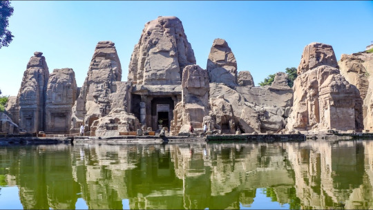
Our team highly recommends adding this beautiful, serene destination to your travel itinerary. We believe the Masroor Rock Cut Temple not only offers a chance to explore an ancient, hidden marvel but also provides visitors with a peaceful retreat amidst the natural beauty of Himachal Pradesh.
#evisaforindia#travel#indiaevisa#indianvisaapplication#evisaindia#evisaindiacost#rockcuttemplemasroor#rockcuttemple#rockcutcaves#masroortemple#rocktemple#rockcuttemplesinindia
0 notes
Text
Final report of Vadakkupattu excavation submitted to ASI
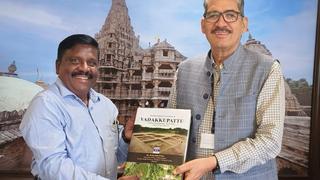
M. Kalimuthu, Superintending Archaeologist, ASI, Chennai Circle, handing over the final report on the Vadakkupattu excavation to Yadubir Singh Rawat, Director General, ASI, in New Delhi on Tuesday. | Photo Credit: Special Arrangement A 700-page detailed final report on the two-phased excavations carried out by the Archaeological Survey of India (ASI), Chennai Circle, at Vadakkupattu village in…
View On WordPress
0 notes
Text
Understanding Electrical Resistivity Survey in India: A Key Tool for Subsurface Investigation
In the field of geophysical exploration, the Electrical Resistivity Survey in India is widely used to assess subsurface conditions, identify potential hazards, and support various projects, from construction to environmental studies. This method, which uses electrical currents to measure the resistance of the ground, provides valuable insights into the composition and characteristics of the Earth's layers without the need for intrusive digging or drilling.
In this blog, we will discuss the importance of the Electrical Resistivity Survey in India, its applications, and why it is an essential tool for projects across the country. We will also explore the use of electrical resistivity meters, the technology behind these surveys, and how they contribute to efficient, safe, and well-planned construction projects.
What is Electrical Resistivity Survey?
An Electrical Resistivity Survey in India is a geophysical technique that measures the electrical resistance of the subsurface materials by passing an electrical current into the ground. Different materials, such as soil, rock, and water, have varying levels of resistance to the flow of electricity. By measuring this resistance, surveyors can map underground features and assess the composition of the ground.
This method is especially useful for determining the presence of groundwater, identifying areas with potential soil instability, and mapping buried structures or voids. In India, the Electrical Resistivity Survey is widely used due to the diverse geological conditions present in the country, from coastal areas to mountainous regions.
How Does Electrical Resistivity Survey Work?
The process behind an Electrical Resistivity Survey in India involves placing electrodes in the ground at specific intervals. An electrical current is then passed between these electrodes, and the resistance of the subsurface materials is measured. The data collected is used to create a detailed map of the underground layers, highlighting areas of interest such as groundwater, bedrock, or potential hazards.
The equipment used for an Electrical Resistivity Survey in India includes electrical resistivity meters, which measure the flow of current and provide data on the ground’s resistance. These meters are vital to the accuracy of the survey, offering real-time insights into the subsurface conditions.
Applications of Electrical Resistivity Survey in India
India’s growing infrastructure demands a thorough understanding of the subsurface conditions before any construction or development can begin. Here are some of the key applications of the Electrical Resistivity Survey in India:
Site Selection for Construction: Before construction projects begin, it is important to assess the ground stability and detect any potential hazards, such as sinkholes, weak soil, or groundwater. The Electrical Resistivity Survey in India helps builders and engineers determine whether the site is suitable for development, reducing the risk of future structural issues.
Groundwater Exploration: In regions where groundwater is a critical resource, such as rural areas and agricultural zones, the Electrical Resistivity Survey in India is used to locate underground water reserves. This is essential for planning irrigation systems, wells, and water management projects.
Environmental Studies: Environmentalists and geologists rely on the Electrical Resistivity Survey in India to monitor changes in groundwater levels, soil contamination, and the impact of construction or mining on the environment. This data helps guide sustainable development and conservation efforts.
Archaeological Investigations: India’s rich history and cultural heritage mean that construction projects often take place near historical sites. The Electrical Resistivity Survey in India allows archaeologists to detect buried artifacts and structures without disturbing the site, ensuring the preservation of important historical elements.
Road and Bridge Construction: For large infrastructure projects like roads and bridges, it is crucial to understand the composition of the ground to ensure the stability and safety of the structure. The Electrical Resistivity Survey in India provides detailed information about the soil and rock layers, helping engineers design more reliable infrastructure.
Landslide Prevention: In regions prone to landslides, such as the hilly areas of India, an Electrical Resistivity Survey can identify weak zones and unstable ground, allowing for preventive measures to be taken. This is crucial for protecting lives and properties in vulnerable areas.
Benefits of Electrical Resistivity Survey in India
There are several reasons why the Electrical Resistivity Survey in India is favored by engineers, geologists, and environmentalists alike. Some of the key benefits include:
Non-Intrusive Method: Unlike traditional methods of subsurface investigation, the Electrical Resistivity Survey in India does not require digging or drilling. This makes it a non-intrusive and environmentally friendly approach to gathering underground data.
Accurate Data: Electrical resistivity meters used in these surveys provide precise and reliable information about the subsurface. This allows for better decision-making, reducing the risk of unexpected issues during construction or excavation.
Cost-Effective: The Electrical Resistivity Survey in India offers a cost-effective way to assess subsurface conditions. By using this method, project managers can avoid unnecessary digging and reduce the chances of costly repairs due to subsurface instability.
Wide Range of Applications: The Electrical Resistivity Survey in India can be used in various fields, from construction and environmental studies to groundwater exploration and archaeology. Its versatility makes it a valuable tool for many industries.
Real-Time Results: With advancements in technology, modern electrical resistivity meters provide real-time data, allowing surveyors to make quick decisions during fieldwork. This speeds up the survey process and minimizes project delays.
Challenges of Conducting Electrical Resistivity Survey in India
Despite its many advantages, conducting an Electrical Resistivity Survey in India comes with its own set of challenges. The country’s diverse terrain, ranging from deserts to dense forests, can make it difficult to carry out surveys in certain areas. Additionally, urbanization and crowded cityscapes often limit the available space for large-scale surveys.
However, advancements in technology have made it easier to adapt to these challenges. Portable and lightweight electrical resistivity meters are now available, allowing survey teams to access remote or difficult-to-reach areas with greater ease.
Conclusion
The Electrical Resistivity Survey in India is a powerful tool that provides valuable insights into the subsurface, supporting a wide range of projects across the country. Whether it’s for construction, groundwater exploration, or environmental monitoring, this method allows for safe, efficient, and well-informed decision-making.
As India continues to develop its infrastructure and manage its natural resources, the Electrical Resistivity Survey in India will remain a key part of ensuring that projects are built on solid ground. By using this non-intrusive and cost-effective method, industries can minimize risks, protect the environment, and contribute to the country’s growth in a sustainable manner.
#Electrical Resistivity Survey in India#Resistivity Survey in India#Electrical resistivity test instrument provider in India
0 notes
Text
Discover the Power of Ground Penetrating Radar (GPR) with Shijay Projects
In the dynamic world of geophysical exploration, Ground Penetrating Radar (GPR) has become an essential tool. Whether your work involves archaeology, engineering, or environmental studies, GPR offers exceptional insights into subsurface structures. At Shijay Projects, a leading geophysical instruments provider in India, we deliver cutting-edge GPR solutions to meet a variety of needs.
What is Ground Penetrating Radar (GPR)?
Ground Penetrating Radar (GPR) is a non-destructive geophysical technique that uses radar pulses to image the subsurface. This technology enables the detection of objects, material changes, voids, and cracks below the surface. GPR is highly versatile, providing high-resolution data invaluable for numerous applications.
Applications of GPR
Archaeology: GPR assists archaeologists in locating and mapping buried artifacts, structures, and human remains without site disturbance.
Engineering and Construction: In construction, GPR locates utilities, detects voids, and assesses the condition of structures such as bridges and roads.
Environmental Studies: Environmental scientists use GPR to investigate soil contamination, monitor groundwater, and study subsurface conditions.
Utility Detection: GPR is commonly used to locate underground utilities like pipes, cables, and storage tanks.
Why Choose GPR from Shijay Projects?
As a premier geophysical instruments provider in India, Shijay Projects offers state-of-the-art GPR systems that are reliable, accurate, and easy to use. Here’s why you should choose our GPR solutions:
Advanced Technology: Our GPR systems feature the latest advancements in radar technology, ensuring precise and detailed subsurface imaging.
User-Friendly Interface: Designed with the user in mind, our GPR systems are easy to operate, even for those with minimal technical experience.
Comprehensive Support: From initial consultation to after-sales service, our team of experts supports your projects every step of the way.
Custom Solutions: Every project is unique. We offer customized GPR solutions tailored to your specific requirements.
Benefits of Using GPR
Non-Invasive: GPR is a non-invasive technique, allowing subsurface exploration without drilling or digging.
High-Resolution Data: GPR provides high-resolution images for detailed analysis of subsurface features.
Cost-Effective: By using GPR, you can avoid costly excavation and drilling, making it a cost-effective solution for subsurface investigation.
Time-Efficient: GPR surveys are quick to conduct, providing real-time results that can expedite project timelines.
How Does GPR Work?
GPR operates by sending a radar signal into the ground and recording the echoes that return from subsurface structures. The time it takes for the radar pulses to return to the surface is measured, and this data is used to construct an image of the subsurface. Different materials reflect the radar waves differently, allowing for the identification of various subsurface features.
Conclusion
Ground Penetrating Radar (GPR) is a powerful tool for anyone involved in subsurface investigation. With its wide range of applications and numerous benefits, GPR is becoming the preferred method for geophysical exploration. At Shijay Projects, your trusted geophysical instruments provider in India, we are committed to providing you with the best GPR systems to meet your needs.
0 notes
Text
APSARA Authority to Preserve Newly Discovered Cambodian Statues
Five ancient statues discovered at Ta Prohm Temple by India's Archaeological Survey are to be preserved by Cambodia's APSARA Authority.
via Khmer Times, 02 February 2024: The Archaeological Survey of India discovered five statues at Ta Prohm Temple’s south gate, including two Buddha Sheltered by a Naga, one Avalokiteśvara, and two damaged Buddha statues. These artifacts, unrelated to the gate’s structure, will be preserved by the APSARA National Authority. Ms. Neth Simon, Archaeologist of the APSARA National Authority, said that…

View On WordPress
#APSARA National Authority#Archaeological Survey of India#Avalokitesvara (deity)#sculpture#Ta Prohm (temple)
0 notes
Text
Archaeologists discover continuous human settlements dating back to 1400 B.C. in Vadnagar, Gujarat |
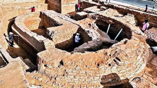
KOLKATA: Researchers from IIT Kharagpur, Archaeological Survey of India (ASI), Physical Research Laboratory (PRL), Jawaharlal Nehru University (JNU) and Deccan College have found evidence of this human settlement that is as old as 800 BCE (before the Christian era). Vadnagar in Gujarat. A statement from IIT Kharagpur said that the study of deep archaeological excavations in Vadnagar also…
View On WordPress
0 notes
Text
MODERN HISTORY
1-The Indus Valley Civilization in water conservation.
The ancient Indus cities were renowned for their well-organized urban layouts, structures made of baked bricks, intricate drainage and water supply systems, groupings of substantial non-residential structures, and the practice of skilled craftsmanship and metallurgy. Mohenjo-daro and Harappa are believed to have possibly accommodated populations ranging from 30,000 to 60,000 inhabitants, and at the height of its development, the civilization may have encompassed a populace ranging from one to five million individuals.
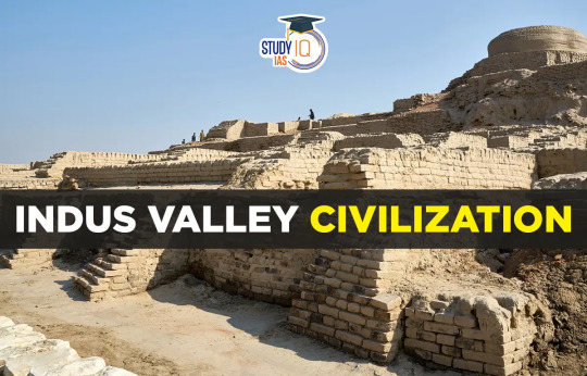
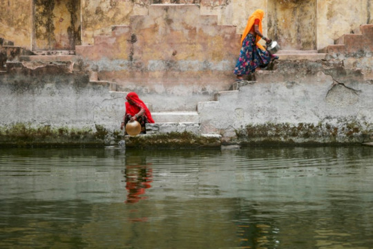
A team of geo-technical engineers from IIT-Gandhinagar, along with an archaeologist from the Archaeological Survey of India (ASI), used Ground Penetrating Radar (GPR) to scan the area and found an intricate system of interconnected water reservoirs, bunds, channels, drains, and checkdams buried 2.5 meters beneath the ground. This discovery suggests that the Harappans may have had advanced knowledge of water management and conservation.


Two significant theories emerged from the GPR data. First, the Harappans might have known how to reduce the turbidity of floodwaters by diverting silt-laden water through interconnected small reservoirs, allowing sediments to settle before reaching a large eastern reservoir for consumption. Second, they may have been adept at controlling floodwaters by building checkdams and specialized water channels, reducing the velocity of water before it entered the main eastern reservoir.
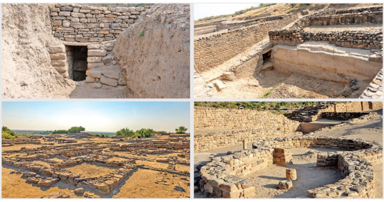
This historical engineering marvel demonstrates early practices in water conservation and sustainable water management, shedding light on the innovative approaches taken by ancient civilizations to address their water needs.

In summary, the discovery of advanced water management systems in the ancient Indus cities of Mohenjo-daro and Harappa is a testament to the knowledge and skills of the Indus civilization. Their ability to reduce turbidity, control floods, and manage water resources through an interconnected structure underscores the historical significance of water conservation practices that resonate with today's challenges.
#water#indus valley#water conservation#harapan#modern history#civilization#water system#water conservation methods
1 note
·
View note
Text
"Wakankaer Award Bestowed Upon ASI's Shivakant Bajpayi: Unveiling Cutting-Edge Conserving Secrets Reviving Ancient Archaeological Culture"
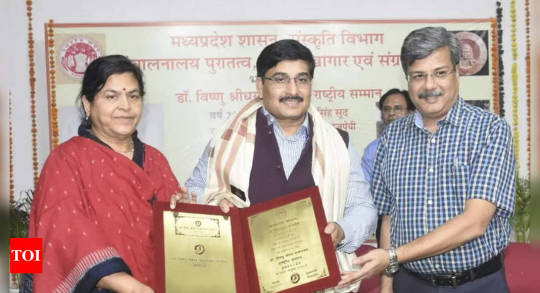
The government of Madhya Pradesh has awarded Shivkant Bajpayi, the superintending archaeologist of the Archaeological Survey of India’s Jabalpur circle, with the prestigious 2021-22 Vishnu Shridhar Wakankaer Rastriya Samman for his contributions to the conservation of archaeological heritage and culture. The Wakankaer award is an annual national award for Indian archaeological studies and…

View On WordPress
0 notes
Text
"Wakankaer Award Bestowed Upon ASI's Shivakant Bajpayi: Unveiling Cutting-Edge Conserving Secrets Reviving Ancient Archaeological Culture"
The government of Madhya Pradesh has awarded Shivkant Bajpayi, the superintending archaeologist of the Archaeological Survey of India’s Jabalpur circle, with the prestigious 2021-22 Vishnu Shridhar Wakankaer Rastriya Samman for his contributions to the conservation of archaeological heritage and culture. The Wakankaer award is an annual national award for Indian archaeological studies and…
View On WordPress
0 notes
Text
"Wakankaer Award Bestowed Upon ASI's Shivakant Bajpayi: Unveiling Cutting-Edge Conserving Secrets Reviving Ancient Archaeological Culture"
The government of Madhya Pradesh has awarded Shivkant Bajpayi, the superintending archaeologist of the Archaeological Survey of India’s Jabalpur circle, with the prestigious 2021-22 Vishnu Shridhar Wakankaer Rastriya Samman for his contributions to the conservation of archaeological heritage and culture. The Wakankaer award is an annual national award for Indian archaeological studies and…

View On WordPress
0 notes
Text
Keeladi: A Window into the Ancient Past
intriguing and mysterious, Keeladi stands as a testament to the rich cultural heritage of ancient India. Located in the Sivaganga district of Tamil Nadu, this archaeological site has captured the imagination of historians and enthusiasts alike. With excavations dating back to the Sangam period, Keeladi offers a window into the lives, culture, and trade practices of the people who once thrived in this region.

Unearthing the Past: Keeladi's Historical Significance
At Keeladi, history comes alive as layers of earth reveal the story of an ancient civilization. The archaeological findings here date back over 2,500 years, showcasing the rich tapestry of a bygone era. The remains of brick structures, pottery, artifacts, and intricate jewelry provide valuable insights into the daily lives and societal structures of our ancestors.
The Sangam Period: A Flourishing Civilization
During the Sangam period, which lasted from 300 BCE to 300 CE, Keeladi flourished as a thriving urban settlement. The excavation site offers a unique opportunity to understand the political, economic, and cultural aspects of this ancient civilization. From trade routes to governance, Keeladi's excavation continues to shed light on the dynamics of the time.
Keeladi's Architectural Marvels
The architecture of Keeladi speaks volumes about the skills and craftsmanship of its inhabitants. From well-planned drainage systems to well-structured brick houses, the site showcases the remarkable engineering feats of the ancient civilization. The symmetrical layout of the town suggests a systematic urban planning approach, a testament to their advanced knowledge in city design.
Rediscovering Keeladi: Modern-Day Excavations
The rediscovery of Keeladi came as a pleasant surprise to historians and archaeologists in the early 2010s. With the backing of the Tamil Nadu Archaeology Department and the Archaeological Survey of India (ASI), systematic excavations began in 2014, unveiling hidden treasures and rewriting history.
The Unearthed Artifacts: Keeladi's Treasures
Keeladi's treasure trove of artifacts offers a glimpse into the daily life, culture, and artistic prowess of the ancient inhabitants. Among the discoveries are intricately designed pottery, terracotta figurines, jewelry made from precious stones, iron tools, and coins that hint at a thriving trade and economic activities during that period.
Social Structure and Cultural Practices
The artifacts and structures at Keeladi reveal the social stratification and cultural practices prevalent in ancient times. From the pottery used by commoners to the exquisite jewelry adorned by the elite, the site paints a vivid picture of the society's hierarchy and lifestyle.
The Mystery of Keeladi's Script
One of the most intriguing aspects of Keeladi is the undeciphered script found on some of the pottery fragments. Archaeologists and linguists continue to puzzle over this ancient script, hoping to unlock the language and gain further insights into the daily communication and record-keeping of the time.
Trade and Commerce: Keeladi's Connection to the World
Keeladi's strategic location near the Vaigai River made it a vital hub for trade and commerce during ancient times. Excavations have unearthed evidence of trade links with the Roman Empire and other distant regions, shedding light on the global connections that shaped the region's history.
Religious Practices and Beliefs
From the remains of sacrificial altars to figurines of deities, Keeladi offers a glimpse into the religious beliefs and practices of the ancient people. The discovery of various religious symbols and artifacts provides valuable insights into the spiritual fabric of the civilization.
Keeladi's Impact on Tamil Nadu's History
The significance of Keeladi goes beyond its archaeological value. It has ignited a sense of pride and curiosity among the people of Tamil Nadu, fostering a deeper connection to their roots. The findings have also fueled academic research and provided a unique opportunity for scholars to delve into Tamil Nadu's history.
Challenges in Preservation and Conservation
Preserving an archaeological site as vast and historically significant as Keeladi poses numerous challenges. Factors such as climate, natural erosion, and human interventions call for meticulous conservation efforts to safeguard the site for future generations.
The Cultural and Educational Value of Keeladi
Keeladi has become a valuable educational resource, offering students and researchers an opportunity to study the evolution of human civilization. It serves as a living history lesson, inspiring future generations to explore the depths of their heritage.
The Controversy Surrounding Keeladi
Like many historical sites, Keeladi has faced controversies and debates surrounding its excavation and preservation. These discussions often revolve around balancing the need for research with the responsibility to protect the site's integrity.
1 note
·
View note
Text
The Role of Resistivity Survey in India’s Geological Exploration
India’s vast and diverse geological landscape offers a wealth of resources, from groundwater to minerals. To tap into these resources efficiently and sustainably, advanced technologies like resistivity surveys play a crucial role. The resistivity survey in India has become an essential tool for geologists, engineers, and environmentalists, helping them explore and understand the subsurface with remarkable accuracy. In this blog, we will explore the importance, applications, and benefits of conducting a resistivity survey in India.
Understanding Resistivity Surveys
A resistivity survey is a geophysical method used to measure the resistance of the earth’s subsurface to the flow of electrical current. This resistance varies depending on the material underground—such as rock, soil, or water—making it possible to map out subsurface structures. By injecting an electrical current into the ground and measuring the resulting voltage, scientists can create a detailed image of the subsurface, identifying areas with different levels of resistivity.
Applications of Resistivity Survey in India
Resistivity survey in India is applied across various fields, each benefiting from its ability to provide a clear picture of what lies beneath the surface. From groundwater exploration to mineral detection, the range of applications is broad and impactful.
Groundwater Exploration: One of the primary uses of resistivity surveys in India is in the exploration of groundwater. India, with its growing population and increasing water demand, faces significant challenges in water resource management. Resistivity surveys help locate aquifers and determine their depth and size, providing crucial information for sustainable groundwater extraction. This method is particularly valuable in arid and semi-arid regions where water resources are scarce.
Mineral Exploration: India is rich in mineral resources, and the resistivity survey in India has become a vital tool in the exploration of these resources. By mapping out the resistivity of different underground layers, geologists can identify areas where minerals like iron ore, bauxite, and copper might be found. This not only helps in locating new mineral deposits but also reduces the risk of unproductive mining activities.
Environmental Studies: The resistivity survey in India is also used in environmental studies to assess soil contamination and monitor landfill sites. By measuring the resistivity of the ground, scientists can detect the presence of contaminants like heavy metals or hydrocarbons, helping to prevent environmental degradation and protect public health.
Archaeological Exploration: Another fascinating application of resistivity surveys in India is in archaeology. This method allows archaeologists to detect and map ancient structures buried beneath the surface without the need for excavation. This non-invasive technique is invaluable in preserving historical sites while still allowing for the discovery of new information about India’s rich cultural heritage.
Infrastructure Development: The planning and development of infrastructure projects, such as roads, bridges, and tunnels, also benefit from the resistivity survey in India. By providing a detailed understanding of the subsurface, engineers can design foundations that are stable and secure, reducing the risk of structural failures and ensuring the longevity of the infrastructure.
Benefits of Resistivity Survey in India
The widespread adoption of resistivity surveys in India has brought about numerous benefits, including increased accuracy in subsurface exploration, cost-effectiveness, and environmental protection.
Increased Accuracy: Traditional methods of subsurface exploration often rely on drilling, which can be both time-consuming and expensive. The resistivity survey in India offers a non-invasive alternative that provides accurate and detailed images of the subsurface, allowing for more informed decision-making in exploration and development projects.
Cost-Effectiveness: Conducting a resistivity survey in India is significantly more cost-effective than traditional exploration methods. By reducing the need for extensive drilling and minimizing the risk of unproductive efforts, this method helps save both time and money. This is especially important in large-scale projects where budget constraints are a major consideration.
Environmental Protection: One of the key advantages of the resistivity survey in India is its minimal environmental impact. Unlike drilling, which can disturb the natural environment and lead to soil erosion or contamination, resistivity surveys are non-invasive and leave the landscape largely undisturbed. This makes them an ideal choice for projects that prioritize environmental sustainability.
Risk Mitigation: The detailed data provided by a resistivity survey in India helps in identifying potential risks before they become major issues. Whether it’s detecting unstable soil layers that could compromise a construction project or identifying areas of groundwater contamination, resistivity surveys provide the information needed to take preventive measures, reducing the likelihood of costly and dangerous problems down the line.
Versatility: The resistivity survey in India is a versatile tool that can be applied across a wide range of fields, from water resource management to archaeology. This versatility makes it an invaluable resource for geologists, engineers, environmentalists, and many others who require accurate subsurface information for their work.
The Future of Resistivity Surveys in India
As India continues to develop and expand its infrastructure, the need for accurate and reliable subsurface exploration methods will only grow. The resistivity survey in India is poised to play an even more significant role in the coming years, with advancements in technology making the process faster, more accurate, and more affordable.
Furthermore, as the country faces increasing challenges related to water scarcity and environmental degradation, the resistivity survey in India will be essential in ensuring sustainable resource management. By helping to locate and protect vital groundwater resources, and by aiding in the cleanup of contaminated sites, resistivity surveys will contribute to a more sustainable and prosperous future for India.
Conclusion
In conclusion, the resistivity survey in India is an indispensable tool in the exploration and management of the country’s natural resources. Its applications in groundwater exploration, mineral detection, environmental studies, archaeology, and infrastructure development highlight its versatility and importance. By providing accurate, cost-effective, and environmentally friendly subsurface imaging, the resistivity survey in India is helping to build a better future for the nation, one that is grounded in sustainable resource management and responsible development practices.
#Resistivity Survey in India#Electrical Resistivity Survey in India#Electrical resistivity test instrument provider in India
0 notes
Text
A look at Pakistan's historical heritage and world UNESCO side Mohenjo Daro
A look at #Pakistan's #historical heritage and #world #UNESCO side Mohenjo Daro A thread ⬇️
Standing on the highest brick platform in Mohenjo-daro’s fort district, just a few steps from a second-century Buddhist stupa, it’s impossible not to feel awe at the sheer scale and complexity of the prehistoric city around you. It takes a moment to grasp the fact that what you’re seeing is more than 4,500 years old, one of the oldest—if not the oldest—known settlements in the entire history of…

View On WordPress
#Archaeological Survey of India#archaeologist#Historical places#Indus Valley Civilization#Mohenjo Daro#National Museum#Pakistan UNESCO Site#Priest King#Sindh#UNESCO#UNESCO Site#World UNESCO Site
1 note
·
View note
Text
“Ramakrishna said the report on Keeladi is the “first of its kind in Tamil Nadu” and took a year to complete. He had begun documentation work in December 2021 with a core group of 10 members comprising archaeologists, experts, draughtsmen, and photographers.
Nearly 6,000 artefacts were unearthed during the first two phases of the Keeladi dig, which the excavation report termed as a “unicultural” site. The report details how Keeladi became an urban centre due to a slow and steady growth in rice production, which also increased internal and external trade and commerce activities. The settlement was also an animal-based economy focused on cattle (cows and bulls), buffalo, sheep, and goats, dated between the 8th century before common era and the 3rd century common era.
According to Ramakrishna, the lack of detailed reports of previous excavations has posed difficulties in documenting Tamil Nadu’s historical record, for instance, in fixing dates. He said the Sangam Period is dated to 300 before common era to 300 common era, based on literary references but archaeology can authenticate these literary references. “It is important to excavate sites, but it is equally important to document everything”, Ramakrishna told Scroll. “
#Tamil Nadu#archaeology#kind of a clickbaity title in the sense that most of the article is about the actual site#and that statement is mostly ‘yeah we just don’t have enough data to actual determine that so let’s slow our roll”
10 notes
·
View notes