#enginnering
Explore tagged Tumblr posts
Text
Have you ever wondered how the McDonnell Douglas F-4 Phantom II, famous for not having an internal gun and paying the price during the first few years of the Vietnam War, actually got one during the course of the war and in relatively short order?

F-4B of the US Navy
Well, it’s really simple: McDonnell Douglas had also developed a recon variant of the Phantom, the RF-4, which basically traded the radar for a camera set, requiring a longer nose to fit it, but which was otherwise identical to the combat variants.

So once the need for an internal gun was made, it was a simple matter of swapping the camera equipment for a gun, and adding the radar back

And thus, the gun-equipped F-4E, was born, giving a starting point for subsequent advanced variants, all equipped with guns.
186 notes
·
View notes
Text

Shinya Kimura.
#motorcycle#shinya kimura#enginnering#customizer#drag racing#sprint racer#flat track racer#sport bike#moto love#lifestyle
16 notes
·
View notes
Text
Admission Enquiry 2025–26 | Top Engineering Colleges in Bangalore

Join RRCE, one of Bangalore's top NAAC A-grade engineering colleges with modern infrastructure and expert faculty. Admissions for 2025–26 are now open.
0 notes
Text
Discover the Power of Ground Penetrating Radar (GPR) with Shijay Projects
In the dynamic world of geophysical exploration, Ground Penetrating Radar (GPR) has become an essential tool. Whether your work involves archaeology, engineering, or environmental studies, GPR offers exceptional insights into subsurface structures. At Shijay Projects, a leading geophysical instruments provider in India, we deliver cutting-edge GPR solutions to meet a variety of needs.
What is Ground Penetrating Radar (GPR)?
Ground Penetrating Radar (GPR) is a non-destructive geophysical technique that uses radar pulses to image the subsurface. This technology enables the detection of objects, material changes, voids, and cracks below the surface. GPR is highly versatile, providing high-resolution data invaluable for numerous applications.
Applications of GPR
Archaeology: GPR assists archaeologists in locating and mapping buried artifacts, structures, and human remains without site disturbance.
Engineering and Construction: In construction, GPR locates utilities, detects voids, and assesses the condition of structures such as bridges and roads.
Environmental Studies: Environmental scientists use GPR to investigate soil contamination, monitor groundwater, and study subsurface conditions.
Utility Detection: GPR is commonly used to locate underground utilities like pipes, cables, and storage tanks.
Why Choose GPR from Shijay Projects?
As a premier geophysical instruments provider in India, Shijay Projects offers state-of-the-art GPR systems that are reliable, accurate, and easy to use. Here’s why you should choose our GPR solutions:
Advanced Technology: Our GPR systems feature the latest advancements in radar technology, ensuring precise and detailed subsurface imaging.
User-Friendly Interface: Designed with the user in mind, our GPR systems are easy to operate, even for those with minimal technical experience.
Comprehensive Support: From initial consultation to after-sales service, our team of experts supports your projects every step of the way.
Custom Solutions: Every project is unique. We offer customized GPR solutions tailored to your specific requirements.
Benefits of Using GPR
Non-Invasive: GPR is a non-invasive technique, allowing subsurface exploration without drilling or digging.
High-Resolution Data: GPR provides high-resolution images for detailed analysis of subsurface features.
Cost-Effective: By using GPR, you can avoid costly excavation and drilling, making it a cost-effective solution for subsurface investigation.
Time-Efficient: GPR surveys are quick to conduct, providing real-time results that can expedite project timelines.
How Does GPR Work?
GPR operates by sending a radar signal into the ground and recording the echoes that return from subsurface structures. The time it takes for the radar pulses to return to the surface is measured, and this data is used to construct an image of the subsurface. Different materials reflect the radar waves differently, allowing for the identification of various subsurface features.
Conclusion
Ground Penetrating Radar (GPR) is a powerful tool for anyone involved in subsurface investigation. With its wide range of applications and numerous benefits, GPR is becoming the preferred method for geophysical exploration. At Shijay Projects, your trusted geophysical instruments provider in India, we are committed to providing you with the best GPR systems to meet your needs.
0 notes
Video
youtube
Inside Bangladesh $1.1 Billion Underwater Tunnel @Kimlud
#youtube#Inside Bangladesh#$1.1 Billion Underwater Tunnel#Bangladesh#construction#railways#enginnering
0 notes
Text
Model-Based Design Tools
ServotechInc offers cutting-edge model-based design tools, revolutionizing engineering processes. These tools enable engineers to create, simulate, and optimize systems in a virtual environment, enhancing efficiency and reducing development time. With ServotechInc's expertise, users can seamlessly transition from conceptualization to implementation. These tools empower teams to collaborate, iterate, and refine designs, ensuring precision and reliability in diverse applications. ServotechInc's commitment to innovation positions them as leaders in delivering state-of-the-art model-based design solutions, empowering businesses to stay ahead in the ever-evolving landscape of technology and engineering. Visit for more info: https://www.servotechinc.com/model-based-design-using-matlab-and-simulink
0 notes
Text
This article delves into the significant influence of simulation software on design and testing processes, highlighting its various benefits, such as time and cost savings, product performance optimization, testing in challenging environments, and fostering collaboration among engineering teams.
0 notes
Text

#cars#car#car dealership#mechanic#ford mustang#classic cars#modern cars#1990#2000s car#1980 car#car model#enginnering#honda#toyota#hyundai#porsche
0 notes
Text

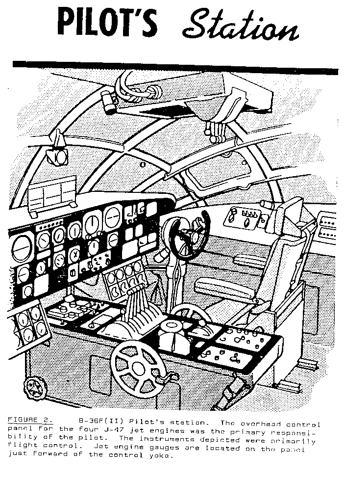
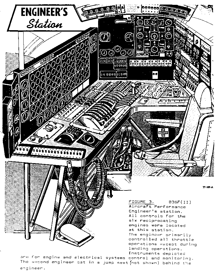
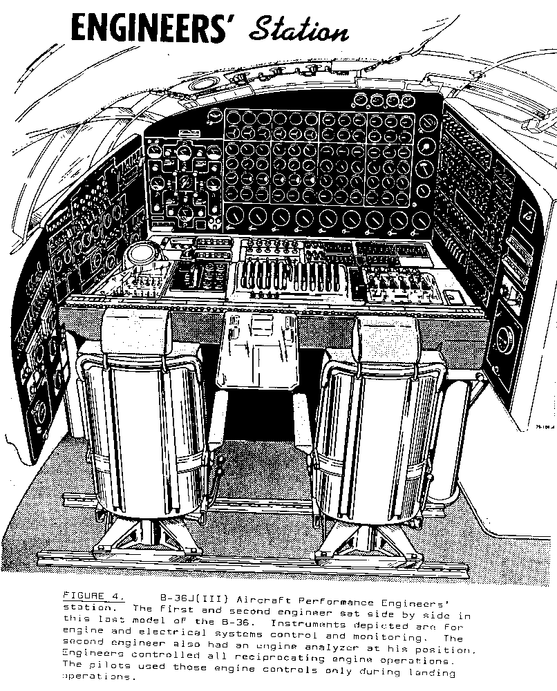

Flight controls of the 10-engine Convair B-36 Peacemaker intercontinental nuclear bomber.

The production aircraft with the most engines ever produced, with a unique quirk in which the flight engineers actually had throttle controls for the engines.
267 notes
·
View notes
Photo

Elektriğin akışı, sessizlik içinde dans eden görünmez bir güçtür, hayatımızı aydınlatırken aynı zamanda dünyayı dönüştüren bir enerjidir.
0 notes
Video
youtube
Best Govt. College at Low Rank मतलब ये Colleges 😱😱 #shikshasamadhan
👉 Download the Shiksha Samadhan App { LINK IN BIO }
0 notes
Photo

Robots Top 10 Récords Mundiales #3
https://www.discmusik.com/2023/04/robots-top-10-records-mundiales-3.html
Hoy te mostraré la evolución que ha tenido los robots en el presente, un sinnúmero de ocupaciones en los cuales pueden emplearse.
https://www.discmusik.com/2023/04/robots-top-10-records-mundiales-3.html
#robot#robots#robotics#tecnology#transformers#ai#enginnering#art#artificial intelligence#arduino#internet#software#apple#sorprendente#curiocidades#interesante#sabiasque#datoscuriosos#sab#datos#curioso#dato#curiocidad
0 notes
Note
Hear me out... TF2 mercs with an easily flustered s/o, like so easily flustered even purring out petnames makes reader bright red and stammering like a school girl with a crush
Blush Crush! ᥫ᭡⋆࣪
Tf2 x Flustered!Reader
A/n: I know I made a poll and everything but this req was so cute I just had to make it!! I tried not to do the wattpad “her face was blushing bright red” stuff so I just said rosy a whole bunch. Enjoy!!
Warnings: None


Medic
❥ Definitely takes him some time to catch onto what’s happening.
❥ You had admired him from a distance since he seemed more attached to his projects than some lovey dovey crushes, but that didn’t stop you from yearning!
❥ Once it was your turn to take the Uber surgery your pulse had been rushing since you sat in that waiting room
“Let’s see.. your blood pressure is pretty good”
“Oh stopp! 🤭”
“..alright then”
❥ He did notice how rosy your skin gets when you’re in the same room, and whenever anyone mentioned his name.
❥ If he Ubers you you’re always on straight PANIC MODE.
‘gasp Oh my god. okay okay, is my stance good? Forget that-do I look good?? I don’t wanna die in front of him but I also don’t want to look stupid!! His eyes are practically glued to me right now! Oh, he’s dead.’
❥ Once he did catch up to what was happening he felt embarrassed himself for not noticing sooner since it seemed so obvious.
❥ Has no idea what to make of it, this guy spends his days experimenting on beheaded spies what do you want him to do?
❥ All of a sudden he was the one blushing and getting all flustered.
❥ He started avoiding eye contact while healing you, kicking the dirt all shyly 😭
❥ He’d deliver love notes via Archimedes, you can barely read it tho cuz he has that doctor hand writing <//3
Scout
❥ oh em gee 😒
❥ Don’t even get him started, he loves making you blush and giggle
❥ Scout is quite bold so as soon as he saw your face turn slightly rosy he became so flirty
❥ He’d do the classic lean against the wall type flirting before matches just to feed his ego before entering battle
“Yeah I’ve been hittin’ the gym recently, gotta get these babies ready for the summer”
“Oh wow! You’re so cool, Jeremy..”
❥ The rest of the team feels like a disappointed dad. “You could’ve done better” type shit
❥ Scout would steal your kills to look like he was “saving” you, you’re too flustered to notice
“Whew, you okay (Y/N)?”
“Oh my god, thank you Jeremy…”
❥ First date was at an arcade so that he could impress you with winning some claw machine prizes *he ended up losing 5x and you got him something instead
❥ Neither of you can get enough of each other, especially after dating. You two are always linking pinkies while the team goes over a plan of some sorts
❥ Y’all are that one hallway couple in high school.
“Alright team, we read- euah.. 😟”
“Sorry Engineer, just giving sum goodluck kisses”
“Eugh creepy, could you get neutered you dog?”
Engineer
❥ Engie does catch on to you being so flustered around him but he sorta doubts himself because he’s unsure if it’ll be a distraction from his work life.
❥ After a few weeks he thought “Hey, why the hell not?”, with how hard you were crushing on him, he was sure that soon enough you’d guys be together
❥ He is quite old fashioned, he’s the type to show up to your door step with flowers and would ask to go out for milkshakes
❥ On your first date he got you a bouquet of flowers he sculpted from metal
“Aww you got me flowers? How sweet..”
“Sure did sugar, my love for you oughta wilt away once it does.”
“….”
“..you good?”
You died.
❥ At least you were able to give him his sunflowers. His favorite kind!!
❥ He’s happy he was able to build up the guts to put himself out there again, he adores you, thinks you’re cute for the most part but also charming in a way.
“So do the sentries build themselves or?”
“Nope, I just gotta be quick with buildin’ then between fights, keeps me sharp”
“You’re so amazing Engie! I could listen to you talk all day ༯”
❥ You’re lucky he finds your swooning cute, otherwise he’d probably build some sentries to make sure you weren’t watching him sleep at night.
#NovaWrites*#fanfic#tf2#tf2 x reader#x reader#medic x reader#scout x reader#enginner x reader#scout tf2#medic tf2#engineer tf2#team fortress 2
258 notes
·
View notes
Text
Exploring Crosshole, Downhole, and Uphole Surveys in Delhi
Geophysical surveys are essential tools in the field of subsurface investigation, enabling engineers and scientists to gain valuable insights into the Earth's subsurface properties. Among these surveys, crosshole, downhole, and uphole surveys are particularly crucial for detailed and accurate data collection. In Delhi, these survey techniques are extensively utilized to support various construction and infrastructure development projects. Let's delve into the specifics of these surveys and understand their significance.
What are Crosshole, Downhole, and Uphole Surveys?
Crosshole Survey
A crosshole survey involves the use of multiple boreholes drilled into the ground, through which seismic waves are transmitted and received. This technique helps in determining the subsurface material properties, including the velocity of seismic waves. By analyzing the travel times of these waves between the boreholes, it is possible to construct a detailed image of the subsurface layers.
Downhole Survey
In a downhole survey, seismic sources and receivers are placed within a single borehole. Seismic waves are generated at the surface, and their travel times to the downhole receivers are recorded. This survey method is particularly effective in identifying the vertical profile of subsurface properties, such as shear wave velocities, which are essential for seismic site characterization.
Uphole Survey
An uphole survey is conducted by placing seismic receivers at various depths within a borehole while the seismic source remains at the surface. This method is used to measure the travel times of seismic waves traveling upwards, providing valuable data on the layering and material properties of the subsurface.
Importance of Crosshole, Downhole, and Uphole Surveys in Delhi
Delhi, being a rapidly growing metropolis, is constantly undergoing construction and infrastructure development. The need for accurate subsurface data is paramount to ensure the safety and stability of these projects. Crosshole, downhole, and uphole surveys in Delhi play a vital role in achieving this goal.
Applications in Construction
One of the primary applications of crosshole, downhole, and uphole surveys in Delhi is in the construction industry. These surveys provide detailed information about the subsurface conditions, helping engineers design foundations, tunnels, and other structures with precision. By understanding the properties of the soil and rock layers, potential issues such as subsidence, liquefaction, and ground instability can be mitigated.
Infrastructure Development
Delhi's extensive infrastructure projects, including metro expansions, highways, and commercial buildings, rely heavily on accurate geophysical data. Crosshole, downhole, and uphole surveys in Delhi enable engineers to assess the suitability of the ground for large-scale construction, ensuring the longevity and safety of the structures.
Environmental Studies
Apart from construction, these surveys are also crucial for environmental studies. Understanding the subsurface conditions helps in assessing groundwater flow, contamination levels, and the impact of construction activities on the environment. Crosshole, downhole, and uphole surveys in Delhi provide essential data for environmental impact assessments and remediation planning.
Advancements in Survey Techniques
With technological advancements, crosshole, downhole, and uphole surveys in Delhi have become more efficient and accurate. Modern equipment and software enable real-time data collection and analysis, reducing the time required for surveys and increasing the reliability of the results.
Data Integration
The integration of survey data with Geographic Information Systems (GIS) and 3D modeling software has revolutionized the way geophysical surveys are conducted. Engineers and geologists can now visualize the subsurface in three dimensions, making it easier to interpret the data and make informed decisions.
Non-Invasive Techniques
In urban areas like Delhi, non-invasive survey techniques are gaining popularity. These methods minimize disruption to the environment and existing infrastructure while providing accurate subsurface data. Crosshole, downhole, and uphole surveys in Delhi are increasingly adopting such techniques to balance data accuracy with minimal impact.
Conclusion
In conclusion, crosshole, downhole, and uphole surveys in Delhi are indispensable tools for modern engineering and environmental studies. Their ability to provide detailed and accurate subsurface data is crucial for the success of construction and infrastructure projects. As technology continues to advance, these survey techniques will become even more integral to the development of safe, sustainable, and resilient urban environments.
1 note
·
View note
Text
CAD/FEA Design and Analysis | ServotechInc
Servotech Inc. offers comprehensive CAD (Computer-Aided Design) and FEA (Finite Element Analysis) design and analysis services to support the design and development of intricate systems and structures. Their skilled team of engineers utilizes state-of-the-art tools and methodologies to create 2D and 3D models, conduct simulations, and optimize designs for functionality, reliability, and cost-effectiveness. By leveraging its CAD and FEA expertise, Servotech Inc. assists clients in reducing design and manufacturing expenses, accelerating time-to-market, and improving overall product quality. With a commitment to quality and client satisfaction, Servotech Inc. is a trusted partner for companies seeking innovative and reliable technical solutions across various industries.
Visit for more info: https://www.servotechinc.com/cadfea-design-and-analysis
0 notes
Text
In India, where top private engineering colleges in Jaipur produce some of the finest minds, students must grasp engineers’ critical role in space exploration. This article will examine how engineers contribute to space exploration and why their role is so important.
0 notes