#Surveyor Civil
Explore tagged Tumblr posts
Visit Tumblr Blog
Explore Tumblr blogs with no restrictions, modern design and the best experience.
Last Seen Tumblr Blogs


Fun Fact
Tumblr has been providing a Korean-language service since 2013.
Text

Hiring for the Oil & Gas Industry in Abu Dhabi! Interviews on: Mark this Date: 28/01/2025 - Chennai +91 93637 51845 | +91 99942 93267 [email protected]
#Surveyor Civil#Technical Engineer Civil / Building#Contracts Engineer#Quantity Surveyor Civil#Electrical Supervisor#Road Safety#MEP Engineer#Project Engineer#Costing Engineer#Welding Engineer#Planning Engineer Lead#Senior Quantity Surveyor (Mechanical)#Quantity Surveyor (Equipment)#Senior Quantity Surveyor (Equipment)
0 notes
Text

Percy Fawcett poses in a 1911 photograph. Photograph Bridgman/ACI
The Man Who Died Searching For The Lost City of Z
In 1925, Explorer and Surveyor Percy Fawcett Disappeared In The Amazon Basin Looking For An Ancient Civilization. Although He Was Inspired By Questionable Sources, We Now Know If His Search was in Vain.
— By Jordi Canal-Soler | June 13, 2024
When the Spanish first ventured into the Amazon Basin in the 1540s, they recorded Indigenous accounts of a lost city of fantastic wealth that they called El Dorado (“the golden”). Over the centuries, many vain attempts were made to locate a lost civilization in the Amazon rainforest.
The last significant attempt to find such a culture was undertaken by British explorer Percy Fawcett. Between 1906 and 1924, Fawcett made seven expeditions across the Amazon Basin, concluding with his doomed quest to find the city he called Z. Fawcett was inspired by his extensive reading of historical sources, including a mysterious document known as Manuscript 512.
A man of extraordinary mental and physical stamina, Fawcett was working at a time when the Amazon region was still largely undocumented by Europeans who sought to explore its jungles and waterways, seeking ancient cities and riches. His disappearance during his search for Z in 1925, in the Mato Grosso region of Brazil, continues to intrigue writers and filmmakers.
Yearning To Explore
Percy Harrison Fawcett was born in 1867 in Torquay, Devon, the English county that had produced many famous explorers and mariners, including Francis Drake and Walter Raleigh.
The son of an aristocrat who had lost his fortune, Fawcett described his childhood as lacking in affection. At age 19, he was commissioned as a lieutenant in the Royal Artillery and sent to outposts of the British Empire.

This image was taken by Percy Fawcett on the upper Acre River in Bolivia, near the Brazil border, during an expedition. The region had suffered greatly at the hands of rubber exploiters. Royal Geographical Society/Getty Images
In 1901, Fawcett joined the Royal Geographical Society of London and traveled to Africa as a surveyor in the service of the British state, tasked with gathering military intelligence. In 1906, he was commissioned by the society to lead an expedition to the Amazon.
Arriving in South America was the moment his whole life changed. Setting out from La Paz to map the vast territory on the borderlands of Bolivia and Brazil, Fawcett often faced hostility from Indigenous peoples angered by rubber barons, who had invaded their lands to extract rubber for use in car and train manufacturing.
For nearly a decade he roamed the Amazon Basin, often the first European to record geographical features such as waterfalls. His writing gives a sense of the awe he experienced:


Fawcett’s Last Journey: After completing seven South American mapping expeditions for Britain’s Royal Geographical Society, Percy Fawcett returned in 1925 to search for the lost city of Z. He left from the same camp where his horse died on a previous expedition and was never heard from again. Source: David Grann, The Lost City of Z: A Tale of Deadly Obsession in the Amazon | NGM Staff
————Route of Fawcett’s 1925 Expedition | ++++++ Railroad
Above us rose the Ricardo Franco hills, flat topped and mysterious, their flanks scarred by deep quebradas [ravines]. They stood like a lost world, forested to their tops, and the imagination could picture the last vestiges of an age long vanished.
The outbreak of World War I interrupted this rich period of exploration, forcing him to return to Europe. Although in his 50s, Fawcett was in peak physical condition, and he proved to be an outstanding soldier.
A Mysterious Manuscript
Fawcett could not shake off the allure of South America, however. So, when the war ended, he returned to Brazil, where he would pursue an idea that led him to his last great adventures and, ultimately, his mysterious death.
Although Fawcett often relied on racist tropes and ideas when he wrote of Brazil’s Indigenous peoples, he also made great efforts to understand their customs and languages.
He lamented the effects of colonialist greed on these societies and became convinced that Spanish and Portuguese accounts from the 16th and 17th centuries of complex civilizations in the rainforest may have had merit. Such accounts mention “very large settlements” as well as “fine roadways in the interior.”
One document in particular fascinated Fawcett. Known as Manuscript 512 and written in Portuguese, it is purportedly an account by adventurers and fortune hunters. In 1753, in search of precious metals, the adventurers found a ruined city boasting monumental buildings, roads, and a plaza, in “each corner of which is a spire, in the style of the Romans.”

Mystery Manuscript! The document that partly inspired Fawcett’s search for Z is kept in Brazil’s National Library. Manuscript 512 is considered a forgery by some scholars, although Fawcett was not the only one who believed it was authentic. Explorer Richard Burton was intrigued by it during his travels in Brazil in the 1860s. National Library, Brazil
Scholars are divided about the manuscript’s authenticity. Skeptics consider it a forgery. Brazil achieved independence from Portugal in 1825. It would have been useful for a new, insecure republic to “discover” a document that described ancient civilizations in its territory—akin to the great Maya sites in Central America. Many at the time, however, accepted the manuscript’s authenticity, including Fawcett, already convinced that early accounts of complex civilizations in the rainforest were accurate. He became obsessed with finding such a place.
In Search of Z
Although Fawcett was inspired by Manuscript 512’s claims, he never intended to find the city it described. The settlement in that document lies, supposedly, in Brazil’s northeast. Citing other sources (which he did not name), Fawcett became convinced that a lost civilization existed in the wild, central-western region of Mato Grosso. He named the city Z.
In April 1925, Fawcett set out from Cuiabá to find it, accompanied by his eldest son, Jack, and his son’s best friend, Raleigh Rimell. The last news from them was in a letter Fawcett sent to his wife: “We shall disappear from civilization until next year. Imagine us ... in forests so far untrodden by civilised man.”
And then they really did disappear. Were they killed by animals or people? Several expeditions were launched in an attempt to clarify what happened, including one headed by Peter Fleming, brother of the James Bond creator Ian Fleming. Many of these ventures also ended in tragedy. And none shed any light on what happened to Fawcett.
In 1952, anthropologist Orlando Villas-Bôas announced he had found the bones of the explorer and that Kalapalo Indians had confessed to killing him. Later forensic analysis showed the remains did not belong to Fawcett.

For a decade, Fawcett roamed the Amazon Basin. His writings, which his son compiled in this posthumous 1953 book, give a sense of the awe he experienced.
Fawcett’s story has had an enduring cultural impact. He is one of the inspirations for the character Indiana Jones. (The Walt Disney Company is a majority owner of National Geographic Media.) The English explorer was also the subject of David Grann’s The Lost City of Z: A Tale of Deadly Obsession in the Amazon, the basis for a 2016 feature film. In his book, Grann quotes Kalapalo Indians, who insist they had not killed Fawcett. They had seen the smoke from Fawcett’s camp for a few days until it stopped. They say he likely died at the hands of “hostile” people in territory to the east.
Although the mystery of his last days may never be fully resolved, Fawcett’s quest for a lost city may be at an end. In the decades since his disappearance, exploration of northeastern Mato Grosso has uncovered the remains of large urban settlements, now located in Xingu Indigenous Park. Named Kuhikugu, the complex includes remnants of streets, bridges, and large squares. Modern lidar scans further suggest that between 1,500 and 400 years ago, this part of the Amazon was indeed the site of a large settlement. While Z’s exact identity and location are still a mystery, Fawcett’s hunch about a hidden ancient city in the region seems to have been correct.
#Lost City#Exploration#Explorers#Mysteries#Rainforest#Treasure Hunting#History Magazine#Percy Fawcett#Lost City of Z#Disappearance | 1925 | Explorer 🧭 | Surveyor | Percy Fawcett#Amazon Basin#Ancient Civilization#Mysterious Manuscript#In Search of Z
2 notes
·
View notes
Text
Exploring the Diverse Landscape of Surveys: Unveiling Different Types
Introduction Civil engineering, as a discipline, relies heavily on accurate and comprehensive data to design, plan, and construct various infrastructure projects. Surveys play a crucial role in gathering this essential information, providing engineers with the data needed to make informed decisions. There are several types of surveys in civil engineering, each serving a unique purpose. In this…

View On WordPress
#accurate measurements#as-built survey#boundary survey#civil engineering data#Civil engineering surveys#construction progress monitoring#construction survey#design accuracy#environmental monitoring#geodetic survey#global mapping#hydrographic survey#infrastructure development#infrastructure projects#land surveyor#legal boundaries#monitoring survey#project planning#property lines#structural integrity assessment#surveying in civil engineering#surveying innovations#surveying technology#topographic surveying#water body survey
2 notes
·
View notes
Text
Surveying is the process of measuring and mapping the features of a particular area. It is a crucial component in construction, mapping, and land use management. Lots of surveyors in the construction field are using surveying as a roadmap for any kind of building construction.
However, as with any measurement process, surveying is prone to errors. There are various sources of errors in surveying, some of which can be significant, and impact the accuracy of the final survey results.
Human Error
One of the most common sources of error in surveying is human error.
This can occur in the form of incorrect measurements or incorrect recordings of data. It can also occur when surveyors make mistakes in their calculations or misinterpret the data they have collected.
#construction news#civil construction#structural engineering#building construction#types of surveying#quantity surveyor#civil#land surveying
3 notes
·
View notes
Text
Prayagraj Smart City Recruitment 2024 for 11 Engineer, IT, Finance, Draughtsman Posts
Prayagraj Smart City Recruitment 2024 – 11 Various Posts Name of the PostNo of PostsProcurement Specialist for Smart City projects01Assistant Managers (IT) for Smart City projects02Project Leader for CM-GRIDS Project01Architect/ Urban Designer for CM-GRIDS Project01Utility Expert for CM-GRIDS Project01Quantity Surveyor for CM-GRIDS Project01Civil Engineer (Pavement Design Expert) for CM-GRIDS…
#Architect/ Urban Designer for CM-GRIDS Project#Assistant Managers (IT) for Smart City projects#Civil Engineer (Pavement Design Expert) for CM-GRIDS Project#Draughtsman for CM-GRIDS Project#Procurement Specialist for Smart City projects#Project Leader for CM-GRIDS Project#Quantity Surveyor for CM-GRIDS Project#Utility Expert for CM-GRIDS Project
0 notes
Text
CAD Drafting Services
At TheDraftRack LLC we work with Land Surveyors, Civil Engineers, Architects as well as various other stakeholders within the AEC industry providing them with an exhaustive rack of specialized CAD drafting & drawing solutions.
0 notes
Text
LAND SURVEYOR - BUILDINGS Job Vacancy in Abu Dhabi, United Arab Emirates
LAND SURVEYOR - BUILDINGS Job Vacancy in Abu Dhabi, United Arab Emirates
LAND SURVEYOR – BUILDINGS Job Vacancy in Abu Dhabi, United Arab Emirates PURPOSE OF THE ROLE: Land surveyors use special equipment to conduct measurements and evaluations of sites for public, government and private property. The responsibilities of land surveyors include developing land survey reports and performing calculations of measurements and evaluations. DUTIES &…

View On WordPress
#land surveyor - buildings job in Abu Dhabi#land surveyor careers in UAE#land surveyor for building construction in Abu Dhabi#land surveyor for infrastructure projects in Abu Dhabi#land surveyor for marine projects in Abu Dhabi#land surveyor for oil and gas industry in Abu Dhabi#land surveyor for precast construction in Abu Dhabi#land surveyor for road works in Abu Dhabi#land surveyor jobs in Abu Dhabi#land surveyor vacancy in Abu Dhabi#land surveyor with AECOM or KEO or Parsons#land surveyor with civil engineering degree in Abu Dhabi#land surveyor with GIS or CAD skills in Abu Dhabi#land surveyor with good communication skills in Abu Dhabi#land surveyor with RTA or DM approval in Abu Dhabi#land surveyor with surveying equipment knowledge in Abu Dhabi#land surveyor with UAE driving license in Abu Dhabi#land surveyor with underground survey experience#senior land surveyor in Abu Dhabi
0 notes
Text
water resources planning | civil engineering project management
Navigating the Future: The Role of Maps and Surveyors in Sustainable Water Resources Planning
Water, the elixir of life, is a finite and precious resource. As the world grapples with population growth, climate change, and environmental degradation, sustainable water resources planning cannot be overstated. In this article, we explore the pivotal role of maps surveyors using their expertise to chart a sustainable course for our planet's most vital asset.
The Significance of Water Resources Planning
Water resources planning is the art and science of managing and allocating water sustainably. It encompasses various activities, from safeguarding water quality to ensuring equitable distribution. With the global population expected to reach 9.7 billion by 2050 and climate change threatening water availability, adequate water resources planning is paramount to secure water for current and future generations.
The Role of Maps in Water Resources Planning
Maps serve as powerful visual tools in water resources planning. They allow planners and policymakers to understand the geographic distribution of water resources, identify vulnerable areas, and assess the impact of land use on water quality. Maps also play a vital role in communicating complex data to stakeholders, making informed decisions accessible to a wider audience.
Surveyors' Expertise in Hydrographic Surveying
Surveyors bring their specialized knowledge to the table through hydrographic surveying. This field involves mapping the physical features of bodies of water, including rivers, lakes, and oceans. Surveyors use a range of equipment, including sonar and GPS technology, to measure depths, map underwater terrain, and identify hazards. Their work is essential for understanding the dynamics of water bodies and ensuring safe navigation.
Topographic Surveys for Watershed Management
Surveying companies contribute to watershed management by conducting topographic surveys. These surveys provide critical elevation data for drainage, runoff, and floodplain management decisions. By mapping the topography of an area, surveyors help identify areas at risk of flooding and design effective flood control measures.
Innovations in Remote Sensing
In recent years, remote sensing technologies have revolutionized how maps are created, and water resources are monitored. LiDAR (Light Detection and Ranging) and satellite imagery enable mapping of high-resolution terrain and water bodies. These technologies offer a wealth of data invaluable for water resources planning, from tracking changes in land use to monitoring the health of ecosystems.
Geospatial Analysis for Water Allocation
Geographic Information Systems (GIS) and geospatial analysis are essential water resource planning tools. They enable planners to overlay multiple layers of information, such as land use, hydrology, and infrastructure, to make informed decisions about water allocation, reservoir management, and drought prediction. GIS allows a holistic understanding of the complex factors influencing water availability.
Challenges in Water Resources Planning
While maps surveyors and surveying companies play a crucial role in water resources planning, they face several challenges. Data accuracy and reliability are paramount, as decisions based on flawed data can have significant consequences. Urbanization and land development can also impact water bodies, altering their flow and quality. Developing sustainable water management policies is an ongoing challenge that requires careful consideration of social, economic, and environmental factors.
Case Studies in Sustainable Planning
Real-world examples demonstrate the impact of collaboration between maps surveyors, and government agencies in achieving sustainable water resources planning. Initiatives that have successfully balanced water allocation, environmental conservation, and community needs serve as inspiring models for future planning efforts.
Community Engagement and Education
Finally, community engagement and education are essential to sustainable water resources planning. Informed and engaged communities can play a crucial role in conserving water, adopting responsible practices, and supporting policies that protect this vital resource for future generations.
In conclusion, maps surveyors and surveying companies are indispensable allies in the journey toward sustainability. Their expertise in mapping, surveying, and data analysis contributes to informed decision-making, fosters sustainable water management, and helps safeguard this precious resource in an era of increasing water scarcity and environmental challenges. Their role remains pivotal in securing water for all as we navigate the future.
Kier + Wright is a company that specializes in providing civil engineering and land surveying services for the planning and construction some of California's most exciting land development projects. Their business is driven by a deep understanding of the importance of people, communities, and the places that bring them together. With every project, they work tirelessly to build connections and strengthen relationships. Through their work, Kier + Wright strives to keep communities moving forward, growing sustainably, steadily, and purposefully toward a better tomorrow.
#civil consultancy companies#civil engineer services#civil engineering project management#construction surveyor#engineering services#water resources planning#surveying companies
1 note
·
View note
Text
Structural Steel Fabricators

At TheDraftRack, we boast a team of skilled and qualified structural engineers who have years of experience in Steel Detailing Service. Our team has the desired to execute any project that requires shop drawings for Steel components, reinforced or pre-cast concrete, roofs, trusses, handrails, and stairs.
0 notes
Text


Southern Reach series (10th Anniversary Editions) by Jeff VanderMeer
Cover art by Pablo Delcan
MacMillan, 2014-2024
Annihilation (2014)
Area X has been cut off from the rest of the world for decades. Nature has reclaimed the last vestiges of human civilization. The first expedition returned with reports of a pristine, Edenic landscape; the second expedition ended in mass suicide, the third in a hail of gunfire as its members turned on one another. The members of the eleventh expedition returned as shadows of their former selves, and within weeks, all had died of cancer. In Annihilation, the first volume of Jeff VanderMeer's Southern Reach Trilogy, we join the twelfth expedition.
The group is made up of four women: an anthropologist; a surveyor; a psychologist, the de facto leader; and our narrator, a biologist. Their mission is to map the terrain, record all observations of their surroundings and of one another, and, above all, avoid being contaminated by Area X itself.
They arrive expecting the unexpected, and Area X delivers—but it’s the surprises that came across the border with them and the secrets the expedition members are keeping from one another that change everything
Authority (2014)
After thirty years, the only human engagement with Area X—a seemingly malevolent landscape surrounded by an invisible border and mysteriously wiped clean of all signs of civilization—has been a series of expeditions overseen by a government agency so secret it has almost been forgotten: the Southern Reach. Following the tumultuous twelfth expedition chronicled in Annihilation, the agency is in complete disarray.
John Rodríguez (aka "Control") is the Southern Reach's newly appointed head. Working with a distrustful but desperate team, a series of frustrating interrogations, a cache of hidden notes, and hours of profoundly troubling video footage, Control begins to penetrate the secrets of Area X. But with each discovery he must confront disturbing truths about himself and the agency he's pledged to serve.
In Authority, the second volume of Jeff VanderMeer's Southern Reach trilogy, Area X's most disturbing questions are answered . . . but the answers are far from reassuring.
Acceptance (2014)
It is winter in Area X, the mysterious wilderness that has defied explanation for thirty years, rebuffing expedition after expedition, refusing to reveal its secrets. As Area X expands, the agency tasked with investigating and overseeing it—the Southern Reach—has collapsed on itself in confusion. Now one last, desperate team crosses the border, determined to reach a remote island that may hold the answers they've been seeking. If they fail, the outer world is in peril.
Meanwhile, Acceptance tunnels ever deeper into the circumstances surrounding the creation of Area X—what initiated this unnatural upheaval? Among the many who have tried, who has gotten close to understanding Area X—and who may have been corrupted by it?
In this last installment of Jeff VanderMeer's Southern Reach trilogy, the mysteries of Area X may be solved, but their consequences and implications are no less profound—or terrifying.
Absolution (2024)
When the Southern Reach Trilogy was first published a decade ago, it was an instant sensation, celebrated in a front-page New York Times story before publication, hailed by Stephen King and many others. Each volume climbed the bestsellers list; awards were won; the books made the rare transition from paperback original to hardcover; the movie adaptation became a cult classic. All told, the trilogy has sold more than a million copies and has secured its place in the pantheon of twenty-first-century literature.
And yet for all this, for Jeff VanderMeer there was never full closure to the story of Area X. There were a few mysteries that had gone unsolved, some key points of view never aired. There were stories left to tell. There remained questions about who had been complicit in creating the conditions for Area X to take hold; the story of the first mission into the Forgotten Coast—before Area X was called Area X—had never been fully told; and what if someone had foreseen the world after Acceptance? How crazy would they seem?
Structured in three parts, each recounting a new expedition, there are some long-awaited answers here, to be sure, but also more questions, and profound new surprises. Absolution is a brilliant, beautiful, and ever-terrifying plunge into unique and fertile literary territory. It is the final word on one of the most provocative and popular speculative fiction series of our time
#book cover art#cover illustration#cover art#halloween#halloween 2024#happy halloween#jeff vandermeer#Pablo Delcan#annihilation#authority#acceptance#absolution#southern reach trilogy#southern reach series#apocalypse fiction#post apocalyptic#post apocalypse#post apocalyptic fiction#sci-fi#science fiction#dystopian science fiction#dystopia#horror#horror scifi
462 notes
·
View notes
Text
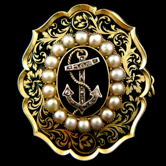

Memorial Brooch to Rear Admiral McKerlie, Died 12th Septr 1848. Aged 74 years, 1848
Rear Admiral John McKerlie (1774-1848) entered the Royal Navy as a volunteer in April 1794 having been at sea in the Atlantic and Baltic merchant service from a young age. Rated Able Seaman, he was sent from the receiving ship Royal William to join the elite frigate force based at Falmouth that cruised the Channel countering the activities of French commerce raiders. McKerlie was assigned to the frigate Arethusa (38) commanded by one of the most successful frigate captains of the day, Captain Sir Edward Pellew.
In early 1795 McKerlie followed Pellew into the 44-gun heavy frigate Indefatigable with the rate of Quarter-Gunner. Owing to a sound Scottish education and his knowledge of the sea McKerlie was soon acting as Indefatigable’s schoolmaster instructing the other eighteen ‘young gentleman’ of the gunroom in the specifics of their profession, having himself been appointed a midshipman. Throughout 1795 and 1796 he participated in the capture of the numerous French prizes which brought further fame and glory to Sir Edward Pellew. It was however early the next year that Indefatigable fought what is generally regarded as one of the boldest frigate actions of the French Revolutionary War.
On the dark and stormy night of 13 January 1797 the French 74 Droits de l’Homme was sighted off the Brittany coast. Pellew, recognizing that he was heavily outclassed, saw that the waves prevented his opponent from opening the lower gun ports and that the severe weather had caused the loss of the enemy’s topmasts. Seizing the initiative, Indefatigable closed followed by the frigate Amazon and raked the French ship of the line at every opportunity. The enemy replied with 4,000 canon balls over the next few hours until finally driven in to Audierne Bay irreparably damaged by British gunfire and the unabated gale. The sight of distant breakers however threatened the destruction of all three ships. Indefatigable, though with masts damaged and with four feet of water in her hold, alone just had time to alter course and escape.
For Pellew the action was a triumph, Lord Spencer at the Admiralty acknowledging that for two frigates to destroy a ship of the line was ‘an exploit which has not I believe ever before graced our naval Annals’. For McKerlie the action was a trauma, costing him his right arm and a severe wound to the thigh. McKerlie's sacrifice was deeply felt Sir Edward Pellew whom he followed to his subsequent command, the mutinous ship of the line Impetueux. While serving aboard the Impetueux, McKerlie participated in numerous boat actions during the Quiberon expedition in 1800, and was present during the planning of a proposed attack on Belleisle. Marshall’s Royal Naval Biography relates how McKerlie ‘…not having heard how he was to be employed, went up to Sir Edward, interrupted him in a conversation with Major-General Maitland, and asking what part he was to act in the event of a debarkation taking place? The answer was “McKerlie you have lost one hand already, and if you loose the other you will not have anything to wipe your backside with; you will remain on board with the first lieutenant and fight the ship as she is to engage an 8-gun battery.”’
The loss of an arm did little to impede McKerlie’s career. He was regarded as a talented surveyor and draftsman, working at onetime with the celebrated civil engineer Thomas Telford. He was also considered a first class shot. He received his lieutenant’s commission in 1804 and served in H.M.S. Spartiate at the Battle of Trafalgar on 21 October 1805. He was present in the capture of Flushing and the Walcheren expedition, and commanded a squadron of ships stationed off Heligoland; oversaw the defence and retreat from Cuxhaven; and was responsible for destroying enemy shipping on the Braak.
Unable to get a command after 1813, McKerlie returned to his native Galloway where he married, Harriet, daughter of James Stewart of Cairnsmuir, had one daughter, Lillias (1821-1915), to either or both of whom the present brooch no doubt belonged. In a post service career McKerlie served as a local magistrate and operated commercial vessels from the port of Garlieston. After almost twenty years ashore, he made an unlikely returned to the Royal Navy as captain of the experimental frigate Vernon between 1834 and 1837. He was awarded a Pension for Wounds on 8 May 1816.
Despite the ever growing kudos that was accorded to Trafalgar veterans in the early Victorian age, it is perhaps with greater pride that Admiral McKerlie recalled his service under Pellew (or Lord Exmouth, as he became); and in 1847 was one of only eight surviving veterans who had lived long enough to apply for the Naval General Service Medal with a clasp for the Droits de L’Homme engagement. The following year, in 1848, he died at Corvisel House, Newton Stewart, at the age of seventy-three.
#naval history#naval artifacts#memorial brooch#18th century#19th century#age of sail#rear admiral mckerlie#trafalgar veteran
183 notes
·
View notes
Note
Hiii!!!
Can you do Thad Carlson hcs?
If that's okay with you :3

Absolutely I’ve wanted to do something with this wet sock of a boy for a while now
•So judging by his voicelines he’s rather snarky. One could even describe him as snobbish. It’s something he picked up from his twin brother, but while Dan is much more well versed in intimidation tactics, out of Thad’s mouth said malice only comes off as half assed attempts at comebacks. They don’t often land either.
•he cannot fucking see . He’s so very short sighted it’s painful. On those premises his glass lenses make his eyes look as beady as a mole’s. They’re knocked off his face so often he had to tape them together to keep them from further crooking.
•Buck teeth. He’s got buck teeth, and a retainer. He should wear it, and oftentimes he avoids it because of how horrid it feels, but when his parents force him to slap it on it amplifies his lisp by the hundredth. Which is why sometimes he sounds normal and other timessss he’s a Daffy Duck impersonator.
•he has a Big interest in geometry and technical drawing as a whole. He wants to be a civil engineer. Or an architect. Maybe both, he hasn’t decided. As long as he can put the subject he’s best at to good use.
•that’s also why he carries so much material. Yardsticks included. If he catches up on homework soon enough he’ll get started on a hypothetical project. Not his fault if his tools have become means to defend himself lmao. He doesn’t really like it though. Having to replace broken rulers on the weekly isn’t the greatest thing for a surveyor the likes of Thad.
•he isn’t often petulant, but if given the chance, he will yap somebody’s head off. He often gets all too carried away while talking (his lisp doesn’t make it all too pleasing to hear) he has to be Abruptly shut up by Earnest. To be fair he’s Often shut up by him anyway. He doesn’t know what to make of it.
•he tries his damn best to be “cool”, or “normal”, or “somewhat socially acceptable”, but it all comes out Wrong. Each and every one of his attempt at smoothing out his persona to the public only gets him slammed back in the nerd box. Earnest thinks he should stop “embarrassing himself”.
•that being said he’s Incredibly and scorchingly jealous of Dan. And Dan rubs the fact he’s so much better off in his face whenever he can. When he’s not ignoring him at home of course. Or throwing crumpled paper balls at him.
•they scuffle on the daily. Even if he’s a tad taller Thad isn’t the strongest kid. Dan’s favorite sibling activity is putting him in a headlock or practicing wwe moves on the poor thing
•Thad however will gladly use him as part of his science project. Against his will.
•love it when siblings love each other


And that’s it I think Thad is a little loser so much that his fumbling about is kind of entertaining. More doodles for you


47 notes
·
View notes
Text


From the New Kingdom, 19th Dynasty, this statue represents the surveyor Pen-Hery, who was in charge of measuring agricultural plots, and determining the properties of state, temples, and private individuals. He holds a twisted rope with a ram’s head on top, representing the Great God Amun. Ropes were used for measuring and determining borders and the areas of large agricultural lands.
Currently residing in the National Museum of Egyptian Civilization in Cairo
#ancient egypt#ancient history#egyptian mythology#egyptian gods#egyptian hieroglyphs#egyptian art#egyptology#archaeology#ancient art#hieroglyphs
255 notes
·
View notes
Text
Have you read...

Area X has been cut off from the rest of the world for decades. Nature has reclaimed the last vestiges of human civilization. The first expedition returned with reports of a pristine, Edenic landscape; the second expedition ended in mass suicide, the third in a hail of gunfire as its members turned on one another. The members of the eleventh expedition returned as shadows of their former selves, and within weeks, all had died of cancer. In Annihilation, the first volume of Jeff VanderMeer's Southern Reach Trilogy, we join the twelfth expedition. The group is made up of four women: an anthropologist; a surveyor; a psychologist, the de facto leader; and our narrator, a biologist. Their mission is to map the terrain, record all observations of their surroundings and of one another, and, above all, avoid being contaminated by Area X itself. They arrive expecting the unexpected, and Area X delivers—but it’s the surprises that came across the border with them and the secrets the expedition members are keeping from one another that change everything.
submit a horror book!
#Annihilation#Jeff Vandermeer#horror books#horror#bookblr#books#scifi horror#scifi#science fiction horror#science fiction#horrorbookpoll#dystopia#southern reach#southern reach trilogy#annihilation 2018#annihilation movie
191 notes
·
View notes
Text
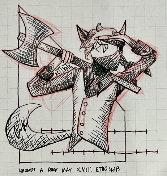
Etho’s here! Perhaps one of the only true jack-of-all-trades this side of the First Dimension, he has played many roles and worn many hats in his decades-long, well, not quite career, since it seems he cannot hold one job for more than a year without growing restless. Known first as a redstone technomancer and engineer, he has spent various seasons of his life as an architect, a wilderness surveyor, a wartime inventor of weaponry, a scientific studying potion-making, a metallurgist, a freelance explorer, and a convicted criminal on the run from the various laws of at least three separate civilizations.
#hermitaday#hermit-a-day may#hermitcraft#ethoslab#traditional art#horizon to horizon au#art for my fic
32 notes
·
View notes
Photo
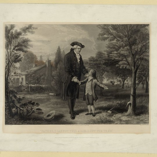
Youth of George Washington
The youth of George Washington (1732-1799), the first President of the United States, remains the least understood chapter of his life, shrouded in folklore and myths. Yet the experiences of his youth, and the bond he felt toward his older half-brother Lawrence, shaped the man he was to become and helped put him on the path toward revolution and the presidency.
Young George Washington with His Father
John C. McRae after G. G. White (Public Domain)
This article examines what is known about the lineage and youth of George Washington, from the first time his great-grandfather set foot on the shores of Virginia in 1657 until George's own coming of age in 1753, a year before the shots fired at the Battle of Fort Necessity changed the trajectory of his own life and, it can be argued, of world history.
Tall, strong, and somewhat physically awkward, the young George Washington grew up on a plantation just outside of Fredericksburg, Virginia, and moved to Mount Vernon as his brother's ward shortly after the death of their father. He became a land surveyor at the age of 16, measuring over 60,000 acres of land along the unmapped western frontier of Virginia. When Lawrence contracted a fatal case of tuberculosis, George accompanied him to Barbados, the only time he ever left the boundaries of the future United States; while there, he had a short but painful bout with smallpox, and for the first time came face to face with the military might of Great Britain. He had experienced much by his 21st birthday in 1753, although nothing could have prepared him for what was still to come.
Family & Parentage
The story of the Washington family in Virginia begins with a shipwreck. On 28 February 1657, the merchant vessel Seahorse of London ran aground on the shoals of the Potomac River during a storm; laden with precious tobacco, the ship had just embarked on its return voyage to England. Among its crew was a young Englishman named John Washington (b. 1633), who had taken to a life at sea after his father, an Anglican rector, had had his properties confiscated for his support of the Royalists during the English Civil Wars (1642-1651). As the crewmen went to work repairing the Seahorse of London, John Washington befriended several locals including Anne Pope, the daughter of a wealthy Maryland planter. It was perhaps out of love for Anne – or perhaps because he spied more opportunity in America than on the open seas – that induced John to stay behind after the crewmen sailed the repaired vessel back to England. John Washington married Anne Pope in late 1658, with the marriage ultimately producing five children.
Before his death in August 1677, John Washington made quite an impression on his adoptive home of Virginia. He had purchased or inherited upwards of 5,000 acres of land, upon which tobacco was planted and harvested by both enslaved Africans and white indentured servants. John's eldest son, Lawrence (b. 1659) was therefore left with a decent inheritance and was perfectly poised to enter public service. Before the age of 25, he served as both the Justice of the Peace and in the House of Burgesses, cementing the place of the Washington family among the colony's landed gentry. Around 1686, he married Mildred Warner, the daughter of the Speaker of the House of Burgesses, with whom he would have three children: John (1692-1746), Augustine (1694-1743), and Mildred (1698-1747). Lawrence died an early death in 1698, after which his widow remarried to an English merchant, George Gale, and moved her children to Whitehaven, England, before she died in 1701. Gale took care of the orphaned Washington children, enrolling the boys in the nearby grammar school at Appleby.
Augustine Washington, the middle child of Lawrence and Mildred, returned to Virginia sometime before he came of age in 1715 to claim his inheritance. Called 'Gus' by family and friends, he was tall, blond, and muscular, and was said to have been as gentle as he was strong. Upon his 21st birthday, he inherited 1,000 acres of land as well as six enslaved people; his marriage to Jane Butler that same year added another 1,700 acres to his already considerable amount of property. The couple settled on Gus' main plot of land at Pope's Creek in Westmoreland County, Virginia, where construction soon began on a home called Wakefield. It was here that Jane gave birth to three surviving children: Lawrence (1718-1752), Augustine, Jr. (1720-1762), and Jane (1722-1735).
Wakefield House at Pope's Creek, Virginia
Benson J. Lossing & William Barritt (Public Domain)
Like his own father, Augustine entered public life, serving as Justice of the Peace and sheriff for Westmoreland County. He also continued buying up properties, including a tract of land near Accokeek Creek, 8 miles (13 km) northeast of Fredericksburg. It was on this land that rich deposits of iron were discovered in the late 1720s; looking to capitalize on this, Augustine began negotiating with the Principio Company, an association of British ironmasters and merchants, to construct an ironworks on the land. In 1729, Augustine went to England to finalize negotiations with his new business partners only to discover upon his return that his wife Jane had died. Distraught though he was, it was not customary for Virginian widowers to stay single for long, and, on 6 March 1731, Augustine Washington was remarried to 23-year-old Mary Ball.
Continue reading...
14 notes
·
View notes