#NMEA
Explore tagged Tumblr posts
Visit Tumblr Blog
Explore Tumblr blogs with no restrictions, modern design and the best experience.
Last Seen Tumblr Blogs


Fun Fact
Mobile US users spent an average of 115.8 minutes on Tumblr app monthly.
Text
youtube
Desk of Ladyada - Triple Matrix Bonnet & u-blox UBX Vibes 🛰️🌍 https://youtu.be/jxZsDak93SY
This week Ladyada updates the TLV320DAC3100 design, developed a triple-matrix bonnet for Raspberry Pi 5 HUB75 RGB matrices, and successfully integrated a u-blox SAM-M8Q GPS module with UART/I2C and UBX interface, exploring GNSS modules with built-in antennas for quick prototyping.
#ladyada#raspberrypi#matrixbonnet#ublox#gpsmodule#electronics#pcbdesign#hardwarehacking#opensource#makers#tech#embedded#prototyping#adafruit#engineering#sam_m8q#hub75#raspberrypi5#rgbmatrix#nmea#ubx#iot#diytech#hardware#innovation#opensourcehardware#electronicsengineering#geek#techinnovation#Youtube
5 notes
·
View notes
Text
Cairns Marine Electronics
Cairns Marine Electronics is a mobile electronics business, specialising in marine equipment. Sales, Installations and repairs to the following equipement: GPS VHF and HF Radio VMS Chart plotters Radar Sonar Sounders Auto pilots Multifunction Devices AIS Marine solar Wind gererators Satellite communications NMEA General DC wiring We can repair to component level Rates: $110 per hour (Inc GST) during business hours. After hour call out rates will apply All call out inspections, repairs require an upfront minimum charge of $110.00 (Inc GST) We charge a minimum $50.00 Inc GST for diagosing any equipement dropped of or delivered. We guarantee our work Mobile servicing in the Cairns region
#Sales#GPS#VHF and HF Radio#VMS#Chart plotters#Radar#Sonar#Sounders#Auto pilots#Multifunction Devices#AIS#Marine solar#Wind gererators#Satellite communications#NMEA#marine electronics#Raymarine#Lowrance#Simrad#Navionics#Furuno#JBL#JRC#GME#Fusion#B & G#Airmar"#component level repairs#electronics#garmin
0 notes
Text
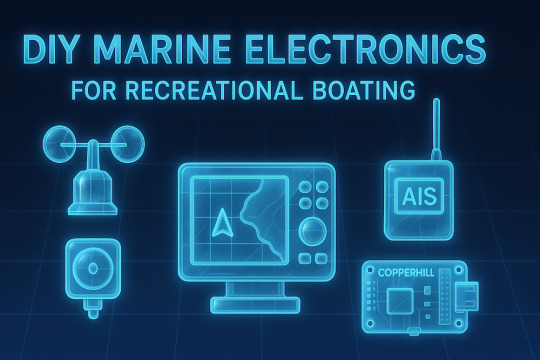
DIY Marine and NMEA 2000 Electronics for Recreational Boating
Explore the world of DIY marine electronics for recreational boating in North America. Discover sensors, GPS modules, CAN bus systems, and NMEA 2000 products from Copperhill Technologies and more—available online for custom boat projects.
#marine applications#DIY#marine electronics#gps#nmea 2000#nmea 0183#signal k#OpenCPN#OpenPlotter#CANBoat
0 notes
Text
#Standard Horizon GX2410GPS#Standard Horizon VHF radio#NMEA 2000 VHF radio#Marine VHF radio with GPS#Wireless marine VHF radio#30W PA system marine radio
0 notes
Text
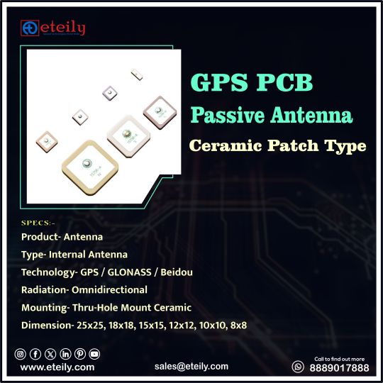
Eteily Technologies India Pvt Ltd
GPS PCB Passive Antenna Ceramic Patch Type
SPECS :
1. Product- Antenna
2. Type-Internal Antenna
3. Technology- GPS/GLONASS/Beidou
4. Radiation-Omnidirectional
5. Mounting-Thru-Hole Mount Ceramic
6. Dimension-25x25, 18x18, 15x15, 12x12, 10x10, 8x8
For More Info -
+91 88890 17888
#eteily#technologies#eteilyindia#telecom#telecommunications#gps#gpstracker#gpsantenna#pcb#india
#gps antenna#gps antenna manufacturer#gnss antenna#gps antenna for car#garmin gps antenna#garmin antenna#trimble gps antenna#gps active antenna#gps patch antenna#external gps antenna#gps antenna types#usb gps antenna#nmea 2000 gps antenna#external gps#marine gps antenna#one lap gps#iridium gps#passive gps antenna#gps antenna for ipad#tracking antenna#fakra gps antenna#neo 6m gps module with arduino#lowrance gps puck
0 notes
Text
Adding GPS to Flipper Zero Wifi Dev Board
Another day, another new project to tinker on. I decided to mod my official Flipper Zero Wifi Dev board to add a GPS module for wardriving functionality in Marauder. The NEO6Mv2 module cost me $3 so it's a cheap hack. You can find it on Aliexpress, etc. First, I hooked up the GPS module to Flipper and ran the NMEA GPS app just to check that the module is working properly, and indeed it was.

The next step is soldering on some pins on the wifi dev board so that I can hookup the GPS.


It's just 4 wires to hookup the GPS module, so it's a pretty simple mod. With that done, I ran Marauder > GPS Data > Stream to check that it's getting GPS feed.

That's it, it works! I will have to redesign and 3D print a new case to fit the GPS and Wifi dev board together. I am also planning to mod the Wifi dev board to add an external antenna and micro SD card slot, so stay tuned.
If you want to try this mod out for yourself, here are some references below to get you started.
ESP32 Marauder: GPS Modification Flipper Zero Wardriving Rig: Upgrade Your WiFi
And this is how you can test the GPS module to make sure it's working. Flipper Zero GPS Receiver Module - NEO-6M
2 notes
·
View notes
Text
Why Suzuki Outboard Motors Are the Ultimate Choice for Boaters in 2025
If you're looking for reliable, fuel-efficient, and powerful outboard motors, Suzuki Outboard Motors should be at the top of your list. Known for innovation and performance, Suzuki continues to lead the marine industry in 2025 with a wide range of outboard engines tailored for every type of boater — from weekend warriors to commercial operators.
What Makes Suzuki Outboard Motors Stand Out?
1. Advanced Fuel Efficiency
Suzuki's Lean Burn Control System adjusts fuel delivery based on operating conditions, significantly reducing fuel consumption without compromising performance. Whether you're cruising or at full throttle, you get maximum mileage and minimal fuel costs.
2. Quiet and Smooth Operation
Noise pollution can ruin a day on the water. Suzuki outboards are engineered with offset driveshafts and vibration-reducing mounts, ensuring whisper-quiet operation and smooth rides even at high speeds.
3. Corrosion Resistance
Saltwater and marine environments can take a toll on your engine. Suzuki combats this with anti-corrosion finishes, sealed electronics, and water-resistant parts—offering durability you can count on for years.
4. Cutting-Edge Technology
From Suzuki Precision Control (SPC) for electronic throttle and shift, to integrated digital gauges and compatibility with NMEA 2000® networks, Suzuki Outboard Motors are built for the future.
Popular Models in the Suzuki Outboard Lineup
DF350A – The flagship V6 with dual prop technology and incredible torque.
DF200A – Lightweight yet powerful, ideal for mid-size boats.
DF60AV – A compact option with high thrust for smaller vessels.
No matter your boating needs, there’s a Suzuki motor that delivers both power and efficiency.
Where to Buy Suzuki Outboard Motors
If you're in the market for a new or used Suzuki outboard motor, look no further than Jet Ski and Outboard Sales. They offer a wide range of Suzuki Outboard Motors for sale, along with expert guidance, warranty options, and fast shipping.
👉 Visit jetskiandoutboardsales.com to browse their latest inventory and find the perfect outboard engine for your boat.
Conclusion
In 2025, performance and reliability on the water matter more than ever. With Suzuki Outboard Motors, you’re not just buying an engine—you’re investing in peace of mind, performance, and longevity. And with trusted retailers like Jet Ski and Outboard Sales, finding your perfect match has never been easier.
SEO Keywords Targeted:
Suzuki Outboard Motors
Buy Suzuki Outboards
Suzuki Outboard Motors for Sale
Best Outboard Motors 2025
Jet Ski and Outboard Sales
Let me know if you'd like this adapted to a specific tone (more casual, more technical, etc.) or reworked as a guest post for another site.
1 note
·
View note
Text
Gps Nmea 0183 Protocol: Understanding The Essential Navigation Standard
GPS NMEA 0183 protocol is a widely used standard for communication between GPS devices and other navigation systems. Microtronix provides solutions that integrate this protocol into embedded applications for seamless data transfer. Whether you're working with GPS receivers or marine navigation systems, our expertise ensures that your system operates with the utmost precision. With the use of this protocol, we help simplify complex data communication for GPS tracking and navigation, ensuring reliable and accurate positioning data. Our team is ready to assist in developing solutions that cater to your specific needs, whether you're designing a consumer product or a professional navigation tool. At Microtronix, we focus on delivering top-notch service and the most effective solutions to support your success.
0 notes
Text
Yacht and Boat Captains in San Diego – Professional Yacht Delivery & Maintenance
When it comes to professional yacht and boat delivery services, Captain Alex Edwards stands out as a trusted name in San Diego. With over 30 years of hands-on experience, Alex Edwards ensures that your vessel is well taken care of, whether you're transporting it along the coast, across Mexico, or anywhere on the West Coast.
Reliable Yacht and Boat Delivery Services
Transporting a yacht requires expertise, precision, and care. Captain Alex Edwards takes pride in providing a safe and seamless yacht delivery experience. With a strong safety record and a reputation for on-time delivery, you can trust that your vessel will arrive at its destination in perfect condition.
Advanced Navigation & Onboard Electrical Systems
Navigating open waters with confidence is key, and Captain Alex Edwards is equipped with advanced technology to ensure a smooth journey. From onboard electrical systems to cutting-edge visual navigation tools, every detail is engineered for precision.
Some of the high-tech systems available include:
AIS Systems
Internet Onboard
NMEA Interfaces
Portable Navigation Systems
Assisted Docking
Autopilot & Digital Control Systems
Marine Radar & Thermal Cameras
VHF Communications
Complete Yacht Management & Maintenance
Owning a yacht is a significant investment, and proper maintenance is essential to keep it in top condition. Captain Alex Edwards offers comprehensive yacht management services in San Diego, ensuring that every aspect of your vessel remains in excellent shape.
Services include:
Washing & waxing
Engine service and repairs
Weekly system checkups
A/C, electronics, and generator maintenance
Prop repair and running gear service
Tracking and monitoring for leaks
A well-maintained yacht speaks volumes about its owner and captain. Keeping your vessel spotless not only enhances its appearance but also ensures its longevity and performance.
Experience the Best Yacht Care in San Diego
Whether you need yacht delivery, navigation assistance, or complete maintenance, Captain Alex Edwards has the expertise to meet all your boating needs. With a commitment to excellence, safety, and customer satisfaction, you can be confident that your yacht is in the best hands.
For more information on our services, visit: https://captainalexedwards.com/services/
To get in touch with Captain Alex Edwards, visit https://captainalexedwards.com/

0 notes
Text
We're vibin' with Claude 3.7 and writing uBlox drivers 😎🤖🛰️
Heeeey, we're just having a super chill vibe here at the desk of Ladyada—writing a driver for the uBlox M8Q
https://blog.adafruit.com/2024/09/10/a-mini-gps-from-ublox-with-i2c-and-uart
, which has both I2C and UART interfaces. As expected, it can do everyday NMEA output, but it can also do UBX, a "compressed" protocol for advanced data reads and writes over I2C/UART—or even SPI on some other chips.
However, the UBX protocol is a hugely complex driver to implement, with dozens of commands and hundreds of flags. But why stress when you can viiiibe? We're using this beast of a spec as an excuse to try out the new Claude 3.7, which is doing great at chomping through the UBX documentation roughage and giving us some nice code on the other side. Within an hour, we're able to connect and switch to UBX mode by sending a well-formed message and receiving an ACK.
What we like about coding with a good LLM is that it does the work we sometimes get lazy over, like handling various error conditions, timeouts, and verbose error messages.
13 notes
·
View notes
Text
https://fnqmarineelectronics.com.au
#GPS#VHF and HF Radio#VMS#Chart plotters#Radar#Sonar#Sounders#Auto pilots#Multifunction Devices#AIS#Marine solar#Wind gererators#Satellite communications#NMEA#General DC wiring#Garmin#Raymarine#Lowrance#Simrad#Navionics#Furuno#JBL#JRC#GME#Fusion#B & G#Airmar
1 note
·
View note
Text
ESP32 Boards for CAN Bus, NMEA 2000, and Raspberry Pi HATs – Ideal for Automotive, Marine, and IoT Projects
Explore advanced ESP32 development boards from Copperhill Technologies featuring CAN FD, NMEA 2000, dual isolated CAN, and Raspberry Pi GPIO compatibility—ideal for automotive, marine, and IoT applications.
#esp32#espberry#can bus#nmea 2000#n2k#sae j1939#marine application#industrial control#iot#iot projects#HAT#raspberry pi
0 notes
Text
0 notes
Text
GPSMAP 5012 Garmin
“USATO GARANTITO” Il GPSMAP 5012, è un chartplotter multifunzione, estremamente resistente, dotato di display XGA touchscreen 12.1”, luminoso e ad alta definizione, che consente di selezionare la destinazione desiderata semplicemente toccando un punto sullo schermo. Compatibile con gli standard NMEA 0183 e NMEA 2000, questo strumento può essere collegato ad una vasta gamma di sensori, motori o…
0 notes
Text

Dual Band L1&L2 GNSS Screw Mount Panel Antenna
SKU: ET-L1L2SC-1L3-SMS
Specs:-
TYPE - Internal PCB Antenna
TECHNOLOGY - GPS L1/L2
FREQUENCY- 1575.42MHz & 1227.6MHz
CONNECTOR- SMA Male Straight
MOUNTING- Panel/Screw/Permanent
For More Info -


#eteily#technologies#eteilyindia#telecom#telecommunications#dualband#gps#sma#connector#rfantenna#india
#gps antenna#gps antenna manufacturer#gnss antenna#gps antenna for car#garmin gps antenna#garmin antenna#trimble gps antenna#gps active antenna#gps patch antenna#external gps antenna#gps antenna types#usb gps antenna#nmea 2000 gps antenna#external gps#marine gps antenna#one lap gps#iridium gps#passive gps antenna#gps antenna for ipad#tracking antenna#fakra gps antenna#neo 6m gps module with arduino
0 notes
Text
Jasne, oto kod dla Arduino, który odczytuje dane z modułu GPS i wyświetla szerokość i długość geograficzną na ekranie LCD:
Potrzebne biblioteki:
* SoftwareSerial.h: Do komunikacji z modułem GPS po serialu (jeśli używasz pinów innych niż sprzętowe TX/RX).
* LiquidCrystal.h: Do obsługi ekranu LCD.
* TinyGPS++.h: Do parsowania danych NMEA z modułu GPS.
Podłączenie:
* Moduł GPS:
* VCC -> 5V Arduino
* GND -> GND Arduino
* TX -> Pin cyfrowy Arduino (np. 2)
* RX -> Pin cyfrowy Arduino (np. 3)
* Ekran LCD:
* Zasilanie i masa zgodnie z instrukcją ekranu LCD
* Piny danych LCD do pinów cyfrowych Arduino (np. 4, 5, 6, 7, 8, 9)
* Pin RS LCD do pinu cyfrowego Arduino (np. 10)
* Pin E LCD do pinu cyfrowego Arduino (np. 11)
Kod:
#include <SoftwareSerial.h>
#include <LiquidCrystal.h>
#include <TinyGPS++.h>
// Piny dla modułu GPS (zmień, jeśli używasz innych)
#define GPS_RX 2
#define GPS_TX 3
// Piny dla ekranu LCD (zmień, jeśli używasz innych)
const int rs = 10, en = 11, d4 = 4, d5 = 5, d6 = 6, d7 = 7;
LiquidCrystal lcd(rs, en, d4, d5, d6, d7);
// Obiekt dla modułu GPS
SoftwareSerial gpsSerial(GPS_RX, GPS_TX);
TinyGPSPlus gps;
void setup() {
// Inicjalizacja komunikacji szeregowej
Serial.begin(9600);
gpsSerial.begin(9600);
// Inicjalizacja ekranu LCD
lcd.begin(16, 2);
lcd.print("Czekam na GPS...");
}
void loop() {
// Odczyt danych z modułu GPS
while (gpsSerial.available() > 0) {
if (gps.encode(gpsSerial.read())) {
if (gps.location.isValid()) {
// Wyświetlanie szerokości i długości geograficznej na ekranie LCD
lcd.clear();
lcd.print("Szerokosc: ");
lcd.println(gps.location.lat(), 6);
lcd.print("Dlugosc: ");
lcd.println(gps.location.lng(), 6);
} else {
lcd.clear();
lcd.print("Brak sygnalu GPS");
}
}
}
}
Wyjaśnienie kodu:
* Inicjalizacja:
* Dołączenie potrzebnych bibliotek.
* Definicja pinów dla modułu GPS i ekranu LCD.
* Utworzenie obiektów dla komunikacji serialowej, ekranu LCD i modułu GPS.
* Setup:
* Inicjalizacja komunikacji szeregowej z modułem GPS i monitorem szeregowym.
* Inicjalizacja ekranu LCD i wyświetlenie początkowego komunikatu.
* Loop:
* Odczyt danych z modułu GPS za pomocą gpsSerial.available() i gps.encode().
* Sprawdzenie, czy dane GPS są poprawne za pomocą gps.location.isValid().
* Wyświetlenie szerokości i długości geograficznej na ekranie LCD za pomocą lcd.print() i lcd.println().
* Jeśli brak sygnału GPS, wyświetlenie odpowiedniego komunikatu.
Uwagi:
* Upewnij się, że masz zainstalowane potrzebne biblioteki (TinyGPS++ i LiquidCrystal).
* Zmień numery pinów w kodzie, jeśli podłączyłeś moduł GPS i ekran LCD do innych pinów Arduino.
* Kod wyświetla szerokość i długość geograficzną z dokładnością do 6 miejsc po przecinku.
* Czasami moduł GPS potrzebuje chwili, aby złapać sygnał. Upewnij się, że jesteś na otwartej przestrzeni, aby moduł mógł odebrać sygnał z satelitów.
1 note
·
View note