#external gps antenna
Explore tagged Tumblr posts
Text

#gps antenna#gps antenna manufacturer#gnss antenna#gps antenna for car#garmin gps antenna#garmin antenna#trimble gps antenna#gps active antenna#gps patch antenna#external gps antenna#gps antenna types
0 notes
Text

Eteily Technologies India Pvt. Ltd.
GPS Marine Antenna With RG58 (L- 3MTR) Cable + N (F) St. Connector
SKU: ET-GPMR-2L3-NFS
For More Info - https://eteily.com/
#eteily#technology#eteilyindia#battery#manufacturers#telecom#fiberglassantenna#rf#antenna#GPS#marineantenna#connector#delhi
#gps tracker antenna#GPS Antenna manufacturers#gps gnss antenna#gps antenna#magnetic gps antenna#gps antenna design#GPS antenna#gps gsm antenna#external gps#gps antenna manufacturer#external gps antenna for android
0 notes
Text
DIY: Marauder with Screen and GPS For Flipper Zero
Many of you would have seen the humongous ESP32 add-on module with touch screen and GPS for Flipper Zero shared in discussion groups, forums, etc. Well, this tutorial will provide you with all the information you need to build one yourself.
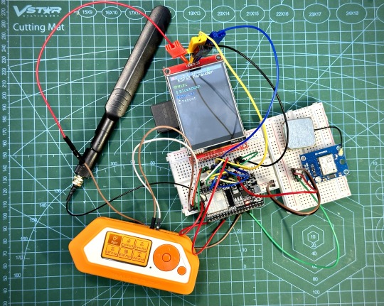
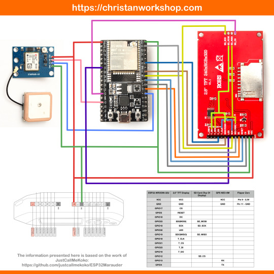
This build consists of mainly 4 parts. The TFT LCD 2.8" 240x320 SPI ILI9341 Touch Display cost me around US$5.50, the ESP32-WROOM-32U module cost around US$3, the NEO-6M GPS module cost around US$2.20 and an 8dbi 2.4GHz Wifi Antenna which cost around US$2. All of these parts can be easily found in online marketplaces like Aliexpress, Amazon, etc. Here is how you need to wire them up together. How you wish to lay this out or mount on a prototyping board is entirely up to you. As long as the connections are correct, you are good to go. The GPS module is optional, and mainly, it's used for the war driving functionality.
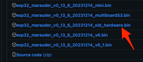
Next, you need to download all the firmware needed from here. Please download the Bootloader, Partitions, Boot App and Firmware files for v4 (Yes, v4 files, not any others) and save it on your computer.
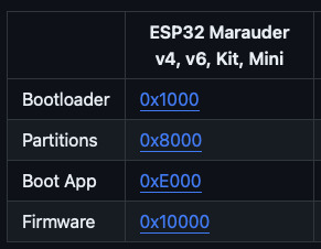
Now, press and hold the BOOT button on your ESP32-WROOM-32U module and connect it to your computer using a data-capable USB cable (some USB cables can only charge), then let go the BOOT button. Open Google Chrome or Microsoft Edge browser and go to ESPWebTool. Click the CONNECT button, then select the ESP32 usb serial connection. It should look something like below but can vary a little between different computers and operating systems.
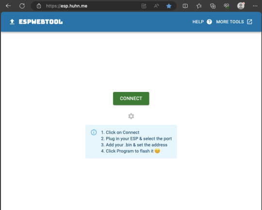
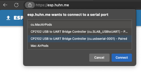
Select the firmware files for each slot exactly like below (take note of the 0x1000, 0x8000, etc. and their corresponding .bin files), then hit the PROGRAM button.
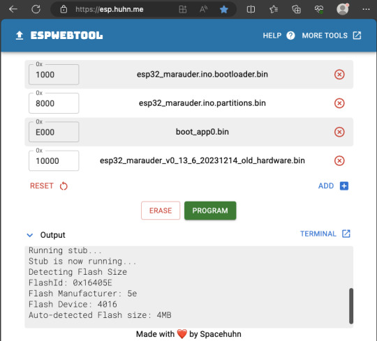
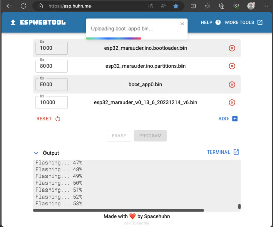
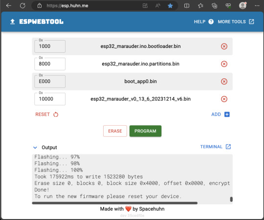
When completed successfully, you can unplug the USB cable from the ESP32 module and now you can connect your Marauder module to your Flipper Zero. Please ensure that your Flipper Zero is turned off before you connect it, and also turn off your Flipper Zero before disconnecting it. The 3.3V pin is also used by your Flipper Zero's SD card reader and connecting/disconnecting external modules that use this pin while the Flipper Zero is on can potentially corrupt the SD card. So, if everything went according to plan, your Marauder module should boot up and everything should look like below.
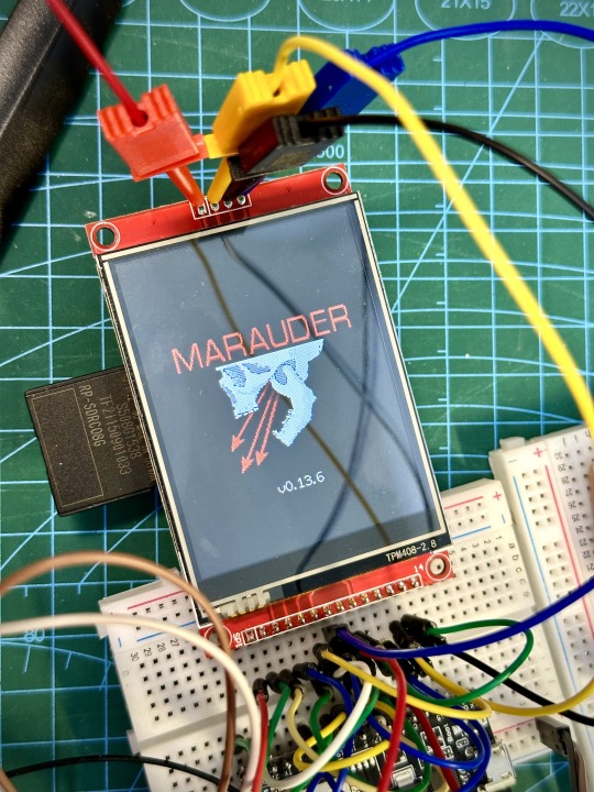
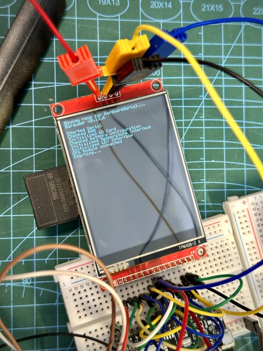
NOTE: If your Marauder boots up, but when you try to touch the screen and get no response, try tapping around the bottom part of your screen and see if the touch panel seems to be in inverted position from the actual display. Should this happen to you, just flash your ESP32 module again following the steps above, but use the v6 firmware. This should resolve the issue.
In this build, I just prototyped this on breadboard, but you can of course make it permanent by soldering it on to a prototype board and 3D print a case for it. This setup is essentially just using the Flipper Zero as a battery pack, instead of using the Flipper Zero to control Marauder. The large screen does make some things easier to do, compared to the small screen of the Flipper Zero, and there may be some functionality (not much) that is not currently in the Flipper Zero Marauder companion app. Here is a video showing the different menus in Marauder.
Personally, I don't think I will actually want to bring something so big around with me, along with my Flipper Zero. I think what makes Flipper Zero special is just how compact it is and all the different functionality cramped into it. This would probably be better off as a standalone unit by just hooking up a battery, but that's just me. Well, that's it for this tutorial. I hope you found this helpful.
Here's a good intro to Marauder if you are unfamiliar.
youtube
16 notes
·
View notes
Text
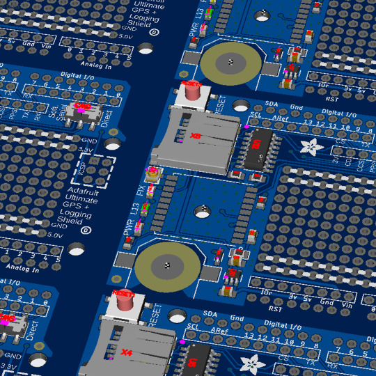
PCB of the day! Ultimate GPS Logger Shield 🌐🔌🛰️
MTK3333 chipset with -165 dBm sensitivity, 10 Hz updates, 99 channels, 30mA power draw, Arduino-compatible. Includes MicroSD slot, RTC battery (7-year backup), built-in & external antenna options, PPS output, LEDs, big prototyping area. Enables high-speed logging/tracking.
#adafruit#electronics#pcb#opensource#opensourcehardware#pcboftheday#gps#arduino#mtk333#gpslogger#shield#sensitivity#lowpower#tracking#arduinocompatible#microsd#rtcbackup#externalantenna#prototyping
17 notes
·
View notes
Text
Also, in the Name of Desaster preparedness and also just in General, it's a good idea to Turn your Smartphone into a device that can still perform SOME of the functions you usually need it for if/when the Internet is down and/or a particular Tech Company changes its Rules or goes out of Business. Which involves installing some open-source Apps that DON'T unneccessarily connect to the Internet, and getting some electronic Accessoires. The Most important of which are Headphones with a cable. If your phone has a headphone jack AND you have a reliable way to keep it charged if the Power is down (Like If you own external batteries/Power Banks and maybe a hand crank Generator), you can use your Phone as a Radio Receiver. The plugged-in Headphones cable will serve as an antenna, and most phones that have a headphone jack also come with a preinstalled Radio Receiver App that can at least do basic scanning.
Also it's super useful to have a 32GB or 64GB Memory Stick that can be plugged into both the USB Port on a Desktop Computer, and the USB-C charging Port on a Smartphone. You can keep some files on there that you may need access to when you evacuate with Just your Phone, or when you have unstable/Limited electricity so you can't afford to start your Desktop Computer but you CAN keep your Phone charged.
Apps that may be useful for when Part of the internet doesn't Work:
Navigation App that works with just GPS and downloadable offline Maps (Like OSMand)
eBook Reader App that is compatible with all the file types and can navigate your phone's internal Memory
some offline Games
apps that make use of your phone's short-range Wireless connectivity for purposes you think you May need (Like file Transfer, local networking...)
Just generally, f-droid is your friend, look into it.
as someone who has gone long stretches without electricity, let alone an internet connection
BACK UP YOUR WORK---YES, EVEN PHYSICAL COPIES. HAVE OFFLINE RESOURCES. KEEP YOUR LANDLINE. CARRY CASH. DON'T GET IMPORTANT APPLIANCES THAT RUN ON WIFI. LEARN TO READ A PAPER MAP
9K notes
·
View notes
Text

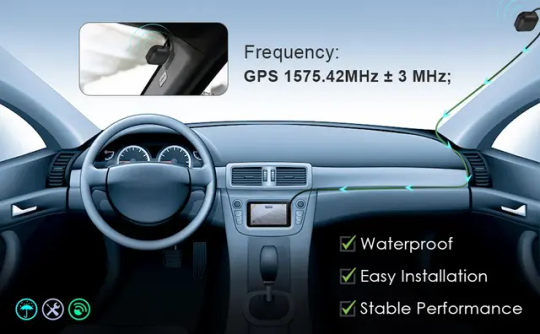


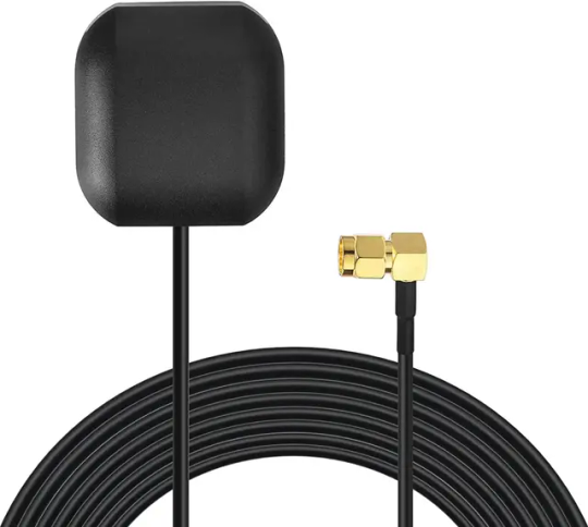

Order now https://netboon.com/product/gps-magnetic-base-antenna-with-right-angle-sma-connector/
GPS Magnetic Antenna | External Navigation Antenna with Right Angle SMA Male Connector
#netboon#GpsMagneticAntenna#ExternalGpsAntenna#RightAngleSmaMaleConnector#GpsNavigationAntenna#VehicleGpsAccessory#GpsSignalAmplifier#CompactGpsAntenna#DurableGpsAntenna#GpsAntennaForNavigation#MagneticGpsAntenna#ExternalGpsAntennaForVehicle#GpsSignalStabilizer#AccurateGpsNavigation#ReliableGpsAntenna#GpsAccessoryForCars
0 notes
Text
How to Prepare Your Vehicle for Auto Transport in Alabama

Transporting your vehicle can be a smooth and stress-free experience when you take the necessary steps to prepare it. Whether you’re moving to a new state, buying a car online, or sending a vehicle to a loved one, proper preparation ensures your car is ready for the journey. This guide provides a step-by-step approach on how to prepare your vehicle for auto transport in Alabama with insights from industry experts like Rapid Auto Shipping.
Why Proper Preparation is Essential
Preparing your vehicle before shipping helps prevent damages, ensures compliance with transport regulations, and makes the entire shipping process seamless. By following these guidelines, you can ensure your vehicle is ready for transport while minimizing potential delays and issues.
Step-by-Step Guide to Preparing Your Vehicle
1. Clean Your Vehicle Inside and Out
Before your car is picked up by the auto transport carrier, thoroughly wash it to remove dirt and grime. A clean car allows you to inspect its condition accurately and document any pre-existing damages.
Take photos from different angles.
Note any scratches, dents, or other imperfections.
Ensure all personal items are removed from the interior.
2. Remove Personal Belongings
Auto transport companies typically do not cover personal belongings inside the car under their insurance policies. Leaving items in the vehicle can also add unnecessary weight and increase the risk of theft.
Remove loose items such as chargers, GPS devices, and valuables.
Check the trunk and glove compartment for any forgotten belongings.
3. Perform a Maintenance Check
Even though your vehicle will be transported on a carrier, it should be in working condition unless specified otherwise. Conduct a basic maintenance check to ensure there are no leaks or mechanical issues.
Key Maintenance Checks:
Check fluid levels: Oil, coolant, brake fluid, and transmission fluid.
Inspect tires: Ensure they are properly inflated.
Check for leaks: Any noticeable leaks should be repaired before transport.
Battery charge: The battery should be fully charged.
4. Disable Alarms and Toll Tags
To prevent unnecessary disturbances during transit, disable any car alarms. If your car has a toll tag or parking pass, remove it to avoid accumulating charges while in transit.
5. Secure Loose Parts and Accessories
To prevent damage, secure or remove any external accessories that could be affected by movement or wind.
Fold in side mirrors.
Remove or secure roof racks, spoilers, and bike racks.
Retract antennas if possible.
6. Reduce Fuel Levels
A full gas tank adds unnecessary weight to the vehicle. Most auto transport companies recommend keeping the fuel level at one-quarter (1/4) of a tank to ensure easy loading and unloading while minimizing weight.
7. Check Insurance Coverage
Although Rapid Auto Shipping and other reputable transport companies provide insurance coverage, it’s important to verify what is included.
Request a copy of the transport company’s insurance policy.
Check your personal auto insurance policy to see if additional coverage is needed.
Document your car’s condition with photos in case a claim needs to be filed.
8. Review Transport Documents Carefully
Before handing over your vehicle, ensure you have all necessary paperwork in place.
Review the Bill of Lading (contract between you and the carrier).
Confirm pickup and delivery dates.
Ask for a direct contact number for the driver or transport company.
9. Understand Pickup and Delivery Procedures
Whether you opt for door-to-door transport or terminal-to-terminal shipping, clarify the pickup and delivery details in advance.
Confirm the designated location for pickup.
Ensure someone is available to receive the vehicle at the destination.
Inspect the car upon delivery and compare it to your pre-transport photos.
Choosing the Right Auto Transport Company
Selecting a trusted company like Rapid Auto Shipping ensures your vehicle is in good hands. When choosing an auto transport provider, consider the following:
Factors to Consider:
Reputation & Reviews: Check online ratings and customer feedback.
Pricing Transparency: Ensure there are no hidden fees.
Licensing & Insurance: Verify that the company is registered with the FMCSA (Federal Motor Carrier Safety Administration).
Service Options: Compare open vs. enclosed transport and standard vs. expedited shipping.
Common Mistakes to Avoid When Preparing Your Vehicle
To prevent delays and complications, avoid these common mistakes:
Leaving personal items in the car – Increases risk of theft and damage.
Not checking for leaks or mechanical issues – May cause problems during transport.
Failing to document the car’s condition – Without proper documentation, it may be difficult to file an insurance claim if needed.
Not verifying insurance coverage – Always confirm what’s covered and ask for additional protection if necessary.
Waiting until the last minute to book shipping – Last-minute bookings may limit options and increase costs.
Frequently Asked Questions
How long does it take to ship a car from Alabama?
The time required for auto transport varies based on the distance and carrier availability. On average, shipping within the U.S. takes 2 to 14 days.
Can I ship a non-running vehicle?
Yes, but you must inform the transport company in advance. Special equipment may be needed, and additional fees may apply.
Should I be present when my car is picked up and delivered?
Yes, or you can assign a trusted representative to be present for inspection and sign the paperwork.
Is open or enclosed transport better for my car?
Open transport is more affordable and suitable for standard vehicles.
Enclosed transport provides added protection, ideal for luxury or classic cars.
Final Thoughts
Understanding how to prepare your vehicle for auto transport in Alabama can make the shipping process hassle-free. By following these steps, you’ll ensure your car is secure and ready for transport. Whether you choose Rapid Auto Shipping or another provider, proper preparation and choosing a reputable company will guarantee a smooth and efficient auto shipping experience.
For professional and reliable auto transport services, consider Rapid Auto Shipping for a stress-free vehicle shipping process.
0 notes
Video
youtube
GPS Pet Tracker
https://7cq2k4d8336ye25n-69770084578.shopifypreview.com/products_preview?preview_key=56bb862a65dd44ea264801a70a3f4d72
Product information: Material: ABS+PVC Model: Z8-A Memory: Standard (M) GPS positioning accuracy: 5-15 (m) Alarm mode: fence alarm Dimensions: 65.5*37*18.3(mm) Battery type: polymer battery Battery usage time: 100000 (h) Waterproof function: yes Antenna Type: GSM/GPRS External power supply form: USB Map function: yes Interface text: none Type Pet: GPS
Note: does not include memory cards
Packing list : Pet Finder*1
0 notes
Text
#eteily technology manufactures#rf antenna#eteily india#rf antenna manufacture#rf antenna price#manufacturing#rf antenna india#entrepreneur#telecom#youtube#gps antenna
0 notes
Text
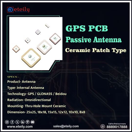
Eteily Technologies India Pvt Ltd
GPS PCB Passive Antenna Ceramic Patch Type
SPECS :
1. Product- Antenna
2. Type-Internal Antenna
3. Technology- GPS/GLONASS/Beidou
4. Radiation-Omnidirectional
5. Mounting-Thru-Hole Mount Ceramic
6. Dimension-25x25, 18x18, 15x15, 12x12, 10x10, 8x8
For More Info -
+91 88890 17888
#eteily#technologies#eteilyindia#telecom#telecommunications#gps#gpstracker#gpsantenna#pcb#india
#gps antenna#gps antenna manufacturer#gnss antenna#gps antenna for car#garmin gps antenna#garmin antenna#trimble gps antenna#gps active antenna#gps patch antenna#external gps antenna#gps antenna types#usb gps antenna#nmea 2000 gps antenna#external gps#marine gps antenna#one lap gps#iridium gps#passive gps antenna#gps antenna for ipad#tracking antenna#fakra gps antenna#neo 6m gps module with arduino#lowrance gps puck
0 notes
Text
Bluetooth trackers and GPS trackers serve similar purposes but operate in different ways and have distinct features:
Bluetooth Tracker:
Range: Bluetooth trackers typically have a shorter range, usually around 100 feet indoors and up to 300 feet outdoors. The range can vary depending on the model and the environment.
Functionality: They rely on Bluetooth technology to connect to a smartphone or other compatible device. Users can track the location of the item to which the tracker is attached using a mobile app.
Battery Life: Battery life is usually longer compared to GPS trackers since they have a smaller range and don't require constant communication with satellites. Some Bluetooth trackers come with replaceable batteries, while others have rechargeable ones.
Accuracy: They are less accurate in pinpointing the exact location compared to GPS trackers. Bluetooth trackers provide a general idea of the item's location based on the last known connection with the smartphone.
#gps tracker antenna#GPS Antenna manufacturers#gps gnss antenna#gps antenna#magnetic gps antenna#gps antenna design#GPS antenna#gps gsm antenna#external gps#gps antenna manufacturer#external gps antenna for android#gps antenna for car#high gain gps antenna
0 notes
Text
Adding GPS to Flipper Zero Wifi Dev Board
Another day, another new project to tinker on. I decided to mod my official Flipper Zero Wifi Dev board to add a GPS module for wardriving functionality in Marauder. The NEO6Mv2 module cost me $3 so it's a cheap hack. You can find it on Aliexpress, etc. First, I hooked up the GPS module to Flipper and ran the NMEA GPS app just to check that the module is working properly, and indeed it was.

The next step is soldering on some pins on the wifi dev board so that I can hookup the GPS.


It's just 4 wires to hookup the GPS module, so it's a pretty simple mod. With that done, I ran Marauder > GPS Data > Stream to check that it's getting GPS feed.

That's it, it works! I will have to redesign and 3D print a new case to fit the GPS and Wifi dev board together. I am also planning to mod the Wifi dev board to add an external antenna and micro SD card slot, so stay tuned.
If you want to try this mod out for yourself, here are some references below to get you started.
ESP32 Marauder: GPS Modification Flipper Zero Wardriving Rig: Upgrade Your WiFi
And this is how you can test the GPS module to make sure it's working. Flipper Zero GPS Receiver Module - NEO-6M
2 notes
·
View notes
Text

VBOX Sport: The ultimate GPS data logger for precision and performance enthusiasts! Waterproof and battery-powered, this cutting-edge device operates at 25 Hz, capturing highly accurate GPS data. Perfect for measuring performance metrics or lap times, its robust design ensures reliability in all conditions.
Features
25 Hz GPS data logging
Performance testing & lap timing
Bluetooth interface to iPhone™ or iPad™
Over 6 hrs battery life
Inbuilt and external GPS antenna
Robust, waterproof, and lightweight enclosure
Contact us for more information: Phone: +91-9371730123 Email: [email protected]
For more details visit - https://gaxcesensors.com/vbox-sport/
0 notes
Text
GSM 4G Router: Revolutionizing Wireless Connectivity
In today’s fast-paced digital world, uninterrupted internet connectivity is essential for both personal and professional activities. The GSM 4G router has emerged as a vital tool for businesses and individuals seeking reliable, high-speed wireless internet. By combining the capabilities of GSM (Global System for Mobile Communications) and 4G LTE technology, this router ensures seamless connectivity, even in remote areas where traditional broadband access may be limited.
What is a GSM 4G Router?
A GSM 4G router is a wireless networking device that uses GSM and 4G LTE networks to provide internet access. Equipped with a SIM card, this router connects to cellular networks, delivering high-speed internet without the need for a wired connection.
Why Choose a GSM 4G Router?
The growing popularity of GSM 4G routers stems from their ability to offer flexibility, mobility, and high-speed internet in various settings. Here are some key reasons to consider this device:
Reliable Connectivity GSM 4G routers provide consistent internet access by utilizing cellular networks, ensuring connectivity in areas without broadband infrastructure.
Portability These routers are compact and portable, making them ideal for remote work, travel, or temporary setups.
Cost-Effective By eliminating the need for wired installations, GSM 4G routers reduce setup costs while providing scalable internet access.
Quick Deployment Unlike traditional routers requiring cabling, a GSM 4G router can be set up in minutes, simply by inserting a SIM card.
Backup Connectivity Businesses can use GSM 4G routers as failover options to maintain internet access during broadband outages.
Features of Advanced GSM 4G Routers
When selecting a GSM 4G router, it’s important to consider the following features:
High-Speed Internet: Support for 4G LTE networks ensures fast download and upload speeds.
Multiple Device Connections: Offers Wi-Fi capability for connecting multiple devices simultaneously.
Built-In Firewall: Provides security features to protect against unauthorized access and cyber threats.
Remote Management: Enables monitoring and configuration through web-based or mobile platforms.
Robust Build: Designed to withstand harsh environments for industrial or outdoor use.
Applications of GSM 4G Routers
Remote Work: Provides flexible internet access for professionals working from home or remote locations.
Surveillance: Powers internet-enabled CCTV systems in areas without wired connections.
Retail and POS Systems: Ensures reliable connectivity for payment systems and inventory management.
Transport and Logistics: Offers real-time GPS tracking and data exchange for fleets.
Smart Homes: Supports IoT devices and smart home systems with a stable internet connection.
Choosing the Right GSM 4G Router
When selecting a GSM 4G router, prioritize compatibility, speed, and additional features such as external antenna support for improved signal reception. Reputable manufacturers ensure reliable products that cater to various business and personal needs.
Leading GSM 4G Router Providers
Aria Telecom Aria Telecom provides high-performance GSM 4G routers tailored for industrial, enterprise, and personal use. Known for reliability and advanced features, their routers ensure uninterrupted connectivity.
Huawei A global leader in networking solutions, Huawei offers robust GSM 4G routers with advanced connectivity options.
TP-Link TP-Link delivers affordable and user-friendly GSM 4G routers suitable for home and small business use.
Netgear Known for their high-quality networking products, Netgear offers GSM 4G routers with excellent speed and coverage.
D-Link D-Link’s range of GSM 4G routers combines affordability with advanced features for both personal and professional applications.
#software#telecommunications#ariatelecom#software engineering#artificial intelligence#ivrsoftware#logo design#technology#devlog#usbvoicelogger
0 notes
Text
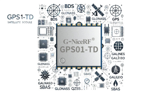
GPS01-TD Module: A Comprehensive Solution for Quad-Mode GPS Positioning and Navigation
In today's rapidly evolving technological landscape, precise positioning capabilities have become a core requirement for various applications. The GPS01-TD module, as an advanced quad-mode GPS module, integrates multi-system compatibility supporting BDS/GPS/GLONASS/Galileo/QZSS/SBAS, with a special emphasis on fully supporting the BeiDou III signals. It provides users with a high-quality, interference-resistant, and low-power positioning and navigation solution. This module is not only technologically advanced but also environmentally friendly and energy-efficient, making it a rare high-performance GPS module choice in the market.
Multi-System Compatibility
The GPS01-TD module supports BDS/GPS/GLONASS/Galileo/QZSS/SBAS, allowing it to provide accurate positioning services globally with its quad-mode compatibility.
It fully supports BeiDou III signals, enhancing positioning accuracy and reliability in the Asia-Pacific region.

High Precision and Fast Positioning
The GPS01-TD module offers high-precision positioning with a tracking sensitivity of -163dBm and a cold start capture sensitivity of -147dBm, ensuring rapid positioning even in weak signal environments. It supports A-GNSS assisted positioning, enhancing startup speed and positioning accuracy.
Design Advantages
With a low-power design, the module is suitable for applications requiring long-term operation, reducing energy consumption and extending device lifespan. It also supports powering active antennas, enhancing signal reception capability and adapting to a wider range of external application needs.
Application Diversity
The module is suitable for personal positioning and navigation products like smartwatches and fitness trackers. It can be used for vehicle and maritime navigation, improving the safety and efficiency of transportation. In IoT devices, such as freight tracking and smart logistics, it provides real-time, accurate location data. Additionally, it is ideal for handheld portable devices like outdoor adventure gear and emergency response equipment, ensuring reliability in various environments.
Strong Interference Resistance
The module employs advanced signal processing technology to enhance interference resistance, maintaining stable performance even in urban areas with tall buildings or complex natural environments.
Global Navigation Assurance
With its quad-mode system providing global coverage, the GPS01-TD module ensures continuous and accurate positioning services regardless of the country or region.
The GPS01-TD module showcases its competitive advantages as an advanced quad-mode GPS module in the market. Whether for commercial applications or personal use, the GPS01-TD offers an efficient and reliable positioning solution. By supporting BDS, GPS, GLONASS, Galileo, QZSS, and SBAS, it ensures seamless navigation services globally, with comprehensive support for BeiDou signals enhancing positioning accuracy and reliability worldwide. This module combines strong interference resistance with a low-power design, making it a highly popular choice for positioning and navigation solutions. Users can rely on the GPS01-TD module to provide continuous and accurate positioning services in complex environments, making it an ideal option for introducing precise and reliable global positioning support across various application fields.
For details, please click:https://www.nicerf.com/products/ Or click:https://nicerf.en.alibaba.com/productlist.html?spm=a2700.shop_index.88.4.1fec2b006JKUsd For consultation, please contact NiceRF (Email: [email protected]).
0 notes