#Image geotag
Explore tagged Tumblr posts
Visit Tumblr Blog
Explore Tumblr blogs with no restrictions, modern design and the best experience.
Last Seen Tumblr Blogs


Fun Fact
US Tumblr user growth rate is estimated to slow down to 4.1%.
Text

#IFTTT#Flickr#chihuly#chihulyglass#dalechihuly#chihulygardenandglass#australianphotographers#colors#colours#olympusep3#microfourthirds#compactcamera#lumixg20f17#usa#seattle#washington#gallery#artwork#glasssculpture#flickr#picture#image#photograph#photo#geotagged#places#travel#fav#favs#favorite
6 notes
·
View notes
Text
Geotag Photos Online

A geotag photo is an image that includes geographical information about where it was taken, such as latitude, longitude, and sometimes altitude. This data is embedded within the photo's metadata, allowing viewers to see the exact location of the shot, making it useful for mapping, travel logs, and location-based services.
#Image Geo Tag#Geotag#Geotag Photo#Geotag Photos Online#Geotagging#identify location from photo online#geotag images#geotag location#Geotagging Software#Geo Tag plan#Geo Tag package#geotag tool#geotagging web app#geofinder
1 note
·
View note
Text
I have not been following western media at all for the past couple of days but I want to know how they have reported about the freed Israel hostage who said that she was treated well with her needs met and literally even turned back to shake hands and say Shalom to those who were releasing her. Was this shown and hyped up on TV channels and news websites? Was her release video played everywhere?
I only saw a clip of Sky News (Australia I think) where they started showing her speaking to the media and immediately cut it off when she started speaking positively...
Oh and what about another Israeli who was talking about how it was their own military who had actually attacked its own people?
I always ask and look for news and updates directly from Israel like we get it from Gaza. If you search for the Tel Aviv geotag on Instagram, it's mostly people chilling in Israel or some pro-Palestine accounts. Is there a possibility that Israel stops their own people from speaking up?
I know western media loves to cherry pick things to show to curate the image that Israel and the US wants them to curate but surely they cannot omit these things.
Here's a random post I just found, adding it here for now

#has the released hostage lady been given a script by Israel yet?#maybe not because she already made her point and pissed everyone off#but also Israel does nottttt care about its hostages or their release#that much is plenty care and obvious now#palestine#free palestine#gaza#free gaza#gaza strip#middle east#israel
2K notes
·
View notes
Text
Part 1
“Take the initiative. Brave the ice,” Carl’s words echo in Buck's head.
Apparently, giving Tommy space is not working anymore. That’s why Buck goes to Tommy’s house the following day and rings the bell.
No one answers.
Buck knocks on the door.
No one answers.
Then Buck yells Tommy into the house.
No one answers.
Buck peeks into the kitchen window.
It’s as dark as the abyss.
Buck recognizes Tommy’s work schedule like the back of his hand. Pilots need a regular timetable, as fatigue is the most dangerous killer in aviation. Tommy should be off today, since his team was on duty the previous day.
Maybe Tommy’s just outside, working on his numerous hobbies, or meeting up with his cool, sexy friends.
But no, the mailbox outside of the pilot’s house is stuffed full of letters, probably due to the small parcel filling up the space. Tommy never leaves his mailbox unchecked.
Is Tommy changing up his work schedule just to avoid running into Buck at work?
There’s only one way to find out.
--------------------------------------------------------------------------
Buck never thought he would find himself staying low in his Jeep, outside of Harbor Station, like a creep.
Yet, the image of Tommy struggling refuses to leave his mind. He has to find out how his ex is doing. The safety of Los Angeles hangs in the hand of this masterful pilot.
So, Buck walks into the 217 station, hoping no one he knows recognizes him.
“Hi,” a seemingly young brunette in a flight suit greets Buck, “can I help you?”
“Um… yeah, I’m looking for Tommy. Is he working today?” Buck asks.
“Uh… I’m sorry, I’m new here. I don’t know everyone yet. Do you have a last name?”
“Yeah, it’s Kinard. K-I-N-A-R-D.”
“Um… It doesn’t really ring a bell…” the young woman walks towards a screen, “I can look at the roster for you.”
“Thanks,” Buck replies, “it’s Tommy, or Thomas, Kinard.”
“Hmm, are you a firefighter too?” the young woman points at Buck’s LAFD hoodie.
“Yeah, I work at the 118. Tommy is a… colleague,” Buck tries his best to sound normal. “I’m Buck, by the way, what’s your name?”
“I’m Rachel.”
Then her expression sombers.
“Um… are you sure he’s still working here?” she furrows her eyebrows. “I don’t see any Kinard on the roster this month… or next month. Maybe he transferred?”
“But — but there’s only one Air Ops in the LAFD,” anxiety hits Buck once again, only double the impact this time. Tommy’s absence is not an accident, it’s planned.
“Look, I’m gonna ask around for you. I’m sure there are people more in the know than I am,” Rachel realizes Buck’s desperation.
“No, it’s… fine,” Buck’s face pales, “I need to… go…”
--------------------------------------------------------------------
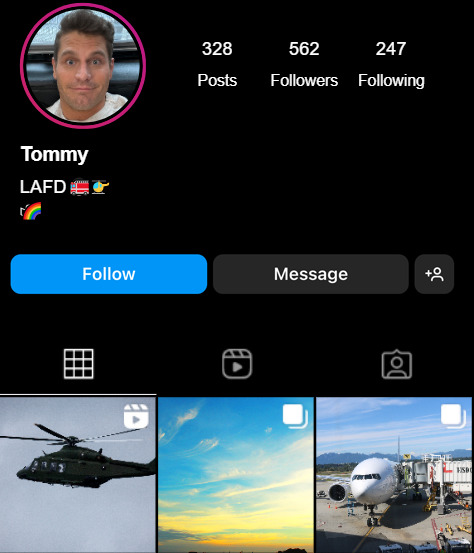
Buck returns to his car and looks up Tommy on Instagram, something he’s been avoiding since Tommy dumped him. He doesn’t want to see his ex having fun, living his best life with a new man.
It soothes Buck’s heart a little, that Tommy’s Instagram page is still filled with photos and videos of aircrafts, his greatest passion.

"A new beginning. Did he really transfer? Just to avoid me?" Buck thinks to himself.
Then Buck realizes, he can browse Tommy's tagged photos to figure out where he is.

Jealousy floods Buck's head for a second, before he realizes Ashley is a woman. She would've been Buck's type in other circumstances, but at the moment, all Buck cares about is if Tommy has a new boyfriend.
It's a girl, so no new boyfriend yet. He looks good though, better than a recently single man would've looked.
Buck finally registers the geotag staring right at him.
Vancouver.
British Columbia.
---------------------------------------------------------------------------
This fic is inspired by the yellow helicopter (N211FN) in 7x03 and the black helicopter (N67TV) Tommy took Eddie to Vegas in 7x04.
They're both in Vancouver now, in a AS350 specialized shop, and their ownerships have been transferred to an aircraft trust in Delaware.
This combination usually means someone else is buying those helicopters. They're not making their way back to their original operators.
Tagging those who wanted to know where Tommy is:
@salty-autistic-writer @louuieferrignojr @sierrarreads @laundryandtaxesworld @here-there-be-fics @thecarrott @o0anapher0o @sherlocking-out-loud @ironworked @louciferssacrament @loulou-land @verschlimmbesserung
#Go get your boy Buck#not really happy with this chapter#but getting it out there before CNY#you get my idea#bucktommy#tommy kinard#evan buckley#tevan#kinley#bucktommy fic#bucktommy fanfic#tevan fic#tevan fanfic#Tommy's in Canada
87 notes
·
View notes
Text
Protection for the Digital Witch: Image Metadata
Just about every image posted online, taken by your camera, or even screenshotted on your phone contains hidden data called metadata. Some of this information is useful, such as how big the image is or how image viewers should render the colors in it. Some of it may be more concerning such as the time the image was taken, where it was taken, where it is saved on your device, what device it was taken on, and more. Mobile phones in particular love to stick metadata on everything that passes through their galleries. While this makes storing and organizing photos a breeze, it can be dangerous to upload photos online when your address is attached to them.
This, of course, raises important questions about online safety and how to keep sensitive information hidden from internet strangers. While there's plenty of resources online about mundane reasons to scrub information from your photos, what can the digital witch take away from this?
Consider metadata as a taglock. Taglocks in witchcraft are footholds for magic to jump from one practitioner's spelltable to another's and they aren't always used for blessings. Anything from a strand of hair to a name to an item you once owned could serve as a taglock and the closer the item is to you, the better. Imagine how powerful a photo of you or your space could be if it also happened to include your location, the time it was taken, and where it was saved on your phone before it hit your blog!
On the flip side, this information can be brandished for good. Photos of meaningful places during fortuitous astrological timing may serve as particularly protective wallpapers. Witches can attach hidden spells or information via image editing tools such as Gimp or Photoshop to their images.
If you work often in digital spaces, keep in mind what information your photos may have and how you can use it to keep yourself safe and explore new mediums for your work!
How to Prevent or Remove Metadata from Photos
Disable Geotagging in your device's settings.
Do a quick Google search to see if your computer or model of phone provides this option!
2. Use a third-party app designed to remove metadata. I recommend an open-source and locally downloaded app like ExifCleaner for PCs or Scrambled Exif for Android. Be wary of third party apps that require you to upload your image to their website, serve you questionable ads, or collect information on you. The goal is to protect your privacy after all!
Further Reading
A Picture is Worth a Thousand Words, Including Your Location
Scrambled Exif
Exif Cleaner
Everything you wanted to know about media metadata, but were too afraid to ask
7 notes
·
View notes
Text
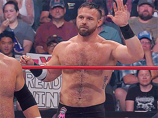
Baby I'm not alright, but I'm okay (Part 7)
Cash Wheeler x f reader
Previous chapter
Waking up this morning, y/n slowly opened her eyes, welcoming the warm sunlight. Daniel had left late last night when the rain stopped, but the scent of his cologne still lingered in the air. y/n smiled at her memories of yesterday. Of the support Dan had given her during her panic attack. Who would have thought he wouldn't walk away scared or tell her, like the others, that she shouldn't act like that.
The girl stretched lazily and got out of bed to make breakfast.
In the quaint and cozy kitchen, a vibrant young lady meticulously crafted culinary masterpieces with an air of unwavering determination. Her hands danced nimbly across the countertop, measuring ingredients with precision and finesse. As she stirred, sautéed, and whisked, the aroma of fragrant spices filled the air, tantalizing the senses. y/n's eyes sparkled with passion as she poured her heart and soul into each dish, blending flavors and textures with impeccable skill. The rhythmic tapping of a knife against the cutting board provided a soothing soundtrack to her culinary symphony, creating a sense of peace and tranquility.

Finished with breakfast, y/n found her phone. Her phone had been bursting with notifications since early morning, but because the sound was off, she hadn't seen any of them until now. Several hundred people had subscribed to her Instagram. Some even wrote messages to her in DMs. Most of them were very toxic messages. In addition to notifications of new subscribers, y/n was tagged in some photos. The girl opened one of them and was horrified to notice that the picture showed her hugging Daniel and geotagging the park they met at yesterday. Things got even worse when y/n read the caption under the photo.
“Wrestling star's private life secret revealed! Cash Wheeler, known for his brutal and little-talking image in the ring, was recently spotted in the company of a mysterious lady. For a long time, Wheeler has shied away from discussing his personal relationships, preferring to keep his private life under wraps...”
Under the photo was a link for the full article on the site. Y/n still didn't understand what it was about her and how she deserved all that was coming at her at once. She opened the link and continued reading the article.
“...This time, however, wrestling fans got a rare chance to see Cash Wheeler in an unusual situation for him. Last night, September 27, a Reddit user posted photos of the pair strolling through a park, exchanging smiles. Usually so focused and stern in the ring, Cash seems to have changed his look, becoming more relaxed and open in the company of his enigmatic companion.
The gossip and speculation have not been long in coming. Reddit users are wondering who is this mysterious girl who won the wrestler's heart? How long have they been together? And how have they managed to keep their relationship a secret until now? Undoubtedly, this exciting event caused a storm of emotions among Cash Wheeler's fans. Fans even found some photos from Dynamite that showed Wheeler's new girlfriend with a full access badge, including backstage.
We were able to find out that Cash Wheeler's new girlfriend Y/n Mercer serves on the Asheville Police Department...”
The girl couldn't read any further. She locked the screen and tossed the phone aside. What to say to her brother and how to explain to him that she wasn't hiding her relationship from him because there was no relationship as such. She and Daniel are just friends, right? At the thought of Wheeler, her lips curved into a nervous smile. How would Dan react? Wouldn't it become a problem for him? Rational thoughts quickly began to override the voice in her head. It was screaming that trouble was coming and she needed to run away sooner rather than later. Literally and figuratively.
Y/n literally ran to her bedroom and started packing quickly. She took only the necessary things: documents, several sets of clothes, a laptop and chargers for her gadgets. Y/n began to gasp with panic. She wasn't ready to go through all of this again and alone. She shook and slid down the wall to the floor. Her eyes filled with tears, her hands were shaking, and she was terribly short of breath.
Y/n sobbed for quite some time. She was just beginning to calm down as she heard her phone ringing in the living room. Getting up on slightly shaky legs, she walked to the common room, picked up her phone and saw a missed call from her brother.
“Damn, I'm not ready for this conversation yet...”
Next chapter
#ftr#cash wheeler x reader#cash wheeler#cash wheeler imagine#dax harwood#x y/n#all elite wrestling#aew#aew x reader#wrestling fanfiction#wrestling fanfic#wrestling fic#wrestling#aew fanfiction#aew fanfic#aew fic#Daniel Wheeler
15 notes
·
View notes
Text
Another thing that is very important when discussing irl violence such as wars between countries, is to make sure any information that you reblog/share isn't giving away identity information. As in, full names and location of random people, HD images of faces, visuals of locations where innocents are hiding, etc.
It can be very tempting to reblog info threads on social media, but the new recordings of events coming in on social media can doxx innocents that are trying to survive, endangering them. It scares me that people online are not taking this into account when they are making info posts...
And to prove I am not being over dramatic about media doxxing: there is a reason you should never take pictures of critically endangered animals and upload the pics to social media. It is common knowledge that poachers will use (and have used) either geotags or the general background to find the location of the endangered animals from things like Twitter posts. It is a very serious issue for wildlife conservation.
So with current facial recognition technology, showing close ups of faces can endanger innocents during conflicts and AFTER conflicts as thier ID info can be saved into a list indefinitely by govt intelligence agencies. I thought this was war 101, but here is the reminder that reblogging and reposting recordings of recent attacks can doxx and endanger innocents.
There is a time and place to share such media to educate, but please be mindful in how you do it. I would recommend blackboxing out the faces of children (including ears) at the very least to protect kid's identities when making posts. Ideally do so to all citizens in pics/videos unless the person is directly making a video of themselves with the intent of sharing such information.
This isn't a "oh please tw" it's a matter of life or death as recent recordings are time sensitive information. Sorry to get so serious on a stupid art blog, but the lapse in judgment i am seeing on twt for example, is deeply worrying. Especially with recent attacks in Rafah that were insidiously timed during the super bowl so that USA/Social media trends would ignore the atrocities... please focus on protecting victims ID/location safety while boosting voices and education.
#Gaza#tw death#Palestine#and this applies to any area or group of people being targetted really#tw war#tw genocide#text#long text#sorry this is probably not worded the best#please read up about world history#please keep boycotting#please keep spreading education#Free palestine
4 notes
·
View notes
Text
Internet PSA #1
For our first psa, I will start with the topic of location.
So what's the big deal with sharing your location? A lot actually.
So many of us have at least a friend or two that shares everything including where they are and where they're going. which seems harmless, right? Wrong!
To you, the close -or decently close- friend, it doesn't mean much. I mean what are you going to do with your friend's location? But what about the internet? That's where things can get not so safe.
Say, you post a picture of a route on a map you're going to take. You zoom it out and cross out the city names. seems good to you! but that location dot on screen is enough. Your city, and the part of it you live in can be found -and easily too!
Why's it important to keep your location secret? Because cyber stalking exists and is very hard to predict. And you don't want a cyber stalker to become an irl stalker.
What information tips people off? Well a lot of simple, little things so I would suggest you avoid posting:
Maps screenshots.
Street signs.
License plates.
Names of local businesses.
Landmarks.
Your town/city name if it's a small area.
Location data from photo geotagging.
and more.
You can protect yourself by refraining from posting personal information online, and to remove such data from images, preferably with an app for photo editing. I suggest ibis paint x if you're on a phone. Also make sure that you turn off geotagging.
That about wraps up our first ever PSA! Feel free to reblog and share.
See you next time, and remember:
Be safe while you browse!
#internet safety#internetsafetyweekly#Internet#safety#internet psa#internet privacy#net safety#safe browsing#important psa#psa#The weekly psa#be safe#Don't overshare#online privacy#keep yourself safe#advice#life advice#internet advice
4 notes
·
View notes
Text
How to Optimize website for Local Organic SEO
Optimizing your website for local organic SEO (Search Engine Optimization) is crucial for businesses targeting a local audience. Here are some steps you can take to enhance your local SEO:
1.Keyword Research:
Identify relevant local keywords that potential customers might use to find your products or services. Use tools like Google Keyword Planner, Ubersuggest, or SEMrush to discover local search terms.
2.On-Page Optimization:
Include local keywords naturally in your page titles, meta descriptions, headers, and content. Optimize your website's URL structure to include location-specific terms. Use schema markup to provide search engines with information about your business, such as address, phone number, business hours, and reviews.

3.Google My Business (GMB) Optimization:
Claim and verify your Google My Business listing.Ensure your business name, address, and phone number (NAP) are consistent across all platforms.Add high-quality images of your business, products, and services.Encourage and respond to customer reviews on GMB.
4.Local Citations:
Ensure your business information is consistent across online directories, social media profiles, and review sites.List your business on popular local directories such as Yelp, Yellowpages, and local chamber of commerce websites.
5.Local Content Creation:
Create content that is locally relevant and valuable to your audience.Write blog posts, articles, or case studies about local events, news, or community activities.Use local landmarks, events, and news in your content.
6.Mobile Optimization:
Ensure your website is mobile-friendly, as many local searches happen on mobile devices.Optimize page loading speed for a better user experience.
7.Local Link Building:
Build local backlinks by partnering with other local businesses, sponsoring local events, or participating in community activities.Engage in local partnerships and collaborations.
8.Social Media Presence:
Be active on social media platforms that are popular in your local area.Share local news, events, and promotions.Use location-based hashtags and geotags in your posts.
9.Online Reviews:
Encourage satisfied customers to leave positive reviews on platforms like Google, Yelp, and Facebook.
Respond promptly and professionally to both positive and negative reviews.
Conclusion:
Remember that local SEO is an ongoing process, and staying up-to-date with changes in search engine algorithms and consumer behavior is essential for continued success. Regularly evaluate your efforts and make adjustments accordingly.
Contact us for our Local SEO consultation to increase your website ranking in search engine results pages today.
3 notes
·
View notes
Text
What is Geotagging?
In today’s digital age, where location-based services are integral to many aspects of our lives, the concept of a geotag has gained significant prominence.
A geotag tool is a form of metadata attached to various types of media, such as photos, videos, and social media posts, that indicates the geographic location where the media was captured or created.
This geospatial metadata typically includes latitude and longitude coordinates, and it can also encompass additional information like altitude, bearing distance, and place names.
The Technology Behind Geotagging
What is Geotagging? Geotagging relies on Global Positioning System (GPS) technology to determine a device's precise location at a given time. Most modern smartphones, cameras, and other digital devices are equipped with GPS capabilities.
When a photo or social media post is taken, the device’s GPS module records the location coordinates and embeds this information into the media file’s metadata.

Applications of Geotagging
Social Media and Photography: One of the most common uses of geotags is on social media platforms such as Instagram, Facebook, and Twitter. Users can attach location information to their posts, allowing followers to see where the content was created.
This feature enhances the storytelling aspect of social media by providing context and relevance to the shared experiences.
2. Navigation and Mapping Services: Geotag photos and posts can be used in navigation and mapping applications like Google Maps and Apple Maps. For example, a geotagged photo of a landmark can appear on a map, helping users discover interesting locations and plan their travels.
3. Real Estate and Property Management: In the real estate industry, geotags are used to provide potential buyers with detailed information about properties.
Photos of houses, apartments, and commercial spaces often include geotags to show the exact location, helping clients make informed decisions based on proximity to amenities, schools, and transportation.
4. Environmental Monitoring: Scientists and researchers use geotagging to monitor environmental changes and wildlife. Researchers can track changes over time and analyse spatial patterns by geotagging photos of plant species, animal sightings, and natural phenomena.
5. Marketing and Business Analytics: Businesses utilize geotagging to understand customer behaviour and optimize their marketing strategies. By analyzing geotagged social media posts, companies can identify popular locations, understand regional preferences, and tailor their advertising efforts accordingly.
Privacy Concerns and Best Practices
While geotagging offers numerous benefits, it also raises privacy concerns. The ability to track and share precise location information can pose risks if not managed properly. To mitigate these risks, users should be mindful of their privacy settings and the potential implications of sharing location data.
Review Privacy Settings: Ensure that your device and social media accounts have appropriate privacy settings to control who can see your geotagged information.
Disable Geotagging: If privacy is a significant concern, you can disable geotagging on your devices, preventing location data from being attached to your media.
Be Selective with Sharing: Consider the location information's sensitivity before publicly sharing geotagged content, especially if it reveals personal or private places.
Conclusion
Geotagging is a powerful tool that enhances the way we capture, share, and analyze information. By providing precise location data, geotags enrich our digital experiences, offering context and depth to the media we create.
However, it is crucial to balance the benefits of geotagging with an awareness of privacy considerations, ensuring that we use this technology responsibly.
Whether for personal use, scientific research, or business analytics, geotags have become integral to our interconnected world, bridging the gap between the digital and physical realms.
#Geotagging#Geotag#Geotag Photos#Geotag Tool#Geotag Photos Online#what is a geotag#geo finder#photo finder#geotag meaning#geotagging software#geotag images
1 note
·
View note
Text
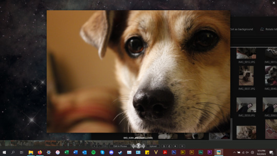
Ok so for all my windows using friends. We all know that new windows photos is dreadful and extra slow and bloaty on slower computers. There is a better solution for photo viewing on your PC, and as an added bonus this comes with a photo managing app that does many of the same things as adobe bridge. Oh and it's free.
What is this stunning software you ask?
Great question! Back in 2002, Google created a nifty piece of software known as Picasa Photos. They eventually killed this software in 2016 to focus on the infinitely more spying Google Photos (I'm not kidding about Google photos having privacy issues. They literally got sued over this in my home state of IL for violating our biometric privacy laws. I got paid $500 from Google for this btw). Moving on, Picasa slapped and that's why they killed it. Fortunately I am not the only Picasa Photo Viewer 3 enthusiast on the internet and there are others who saved the installation exe files. That said, I have helpfully found one that works which you can now download from my google drive here. Note that you cannot use the Google Photos/Google Account related options in the software anymore as Google has discontinued support for it.
Picasa has it all for the person who needs a good photo organizer:
finds ALL photos in your documents, downloads, and pictures folders for you.
ability to open and edit camera raw files
ability to add tags to photos, sort into folders, locate in the system etc.
basic photo editing tools with a good histogram. one of the best editing tools they have, which I would argue is almost on par with a tool from the adobe camera raw editor is the "neutral color picker" tool, where you can select an area in the picture to set a custom white balance in the image (easiest, best color correction). Also contains a primitive healing brush tool.
very good at red eye removal. I used that feature a lot back in 2005.
good printing options (easy to print multiple copies of the same photo on the same page in a variety of standard sizes.
ability to create a photo collage with multiple photos or a photo slideshow video
sort by person tool
lots of fun filters to apply to images if that's your thing.
add custom geotags to photos using another dated google product, google earth.
create a gift cd of photos or create poster sized versions of your photos that print over multiple sheets somewhat like the rastrabator.
the image viewer part is slick, lightweight and fast unlike windows photos. It allows you to quickly arrow key through your photos in a very nice way.
Allow me to show you some screenshots of this glorious piece of abandonware.
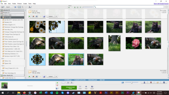


anyways, tldr; this piece of abandonware is the best, most glorious free photo viewer for windows, and as a person who's been using it for the last 18 years I highly recommend it to everyone who does not have adobe PS & Bridge and also anyone with windows who wants a quick way to preview photos in their folders.
2 notes
·
View notes
Text
[Image description:
Tweet from Laura Loomer.
There's a new app where citizens can report illegal aliens and foreigners engaged in criminal activity AND get paid in crypto for doing so! On @.LoomerUnleashed, I spoke with independent journalist @.JacobEngels about how the ICE Raid app iceraid.us uses geotagged submissions, AI verification & tip-sharing to assist local & federal law enforcement in catching illegal aliens who need to be DEPORTED. This is what crowd-sourced patriotism looks like. Report and deport!
2. Facebook post from Branislav Slantchev.
Every 1 in 50 citizens of communist East Germany was an informant to the Stasi, the government security services. Millions of Soviet citizens were informants for the KGB. This sort of snitching culture destroys social trust my making everyone a suspect and suppresses speech because one never knows who's listening and how they might report what was said. The latter is especially insidious because these reports were very often used to settle private grievances by getting people in trouble with the state. When the archives of Bulgaria's State Security were opened, my parents refused to see their files — they simply couldn't handle the possibility that the names of some of the family's closest friends might be on them.
This is what these goons are trying to turn America into. They wish to destroy the fabric of society by turning neighbor against neighbor and inserting the federal government as an arbiter of social relations.
/end description]

1K notes
·
View notes
Text
Micro Dual EO 40x Hybrid Zoom Gimbal Camera with IR - Q818X

Q818X is a lightweight 3-axis gimbal camera integrating dual EO sensors and an IR thermal sensor. Featuring 40x EO hybrid zoom and wide/narrow FOV switching, it delivers high-resolution imaging and precise target tracking in a micro-sized body. Equipped with a high-sensitivity thermal imager and advanced stabilization, Q818X is designed for drone applications in public security, power inspection, firefighting, and long-range observation.
Key Features
Dual EO Sensor, 40x Hybrid Zoom
7mm wide-angle lens + 16mm telephoto lens
5x digital zoom (wide) + 8x digital zoom (tele)
Seamless FOV switching from 66° to 26°
Integrated IR Thermal Camera
18mm thermal lens, HFOV 24°
640×512 resolution, 12μm pixel pitch
Three color palettes: White hot / Black hot / Pseudo hot
Synchronized EO/IR Zoom
Zoom in both EO and IR simultaneously for dual-spectrum clarity
Picture-in-Picture Mode (PIP)
View EO and IR images simultaneously for efficient multitasking
DRI (Detect/Recognize/Identify) Capability
Car: Detect 1000m, Recognize 500m
Human: Recognize 250m
Intelligent Object Tracking
60Hz deviation pixel update rate
CNC Aluminum Housing
Precision-machined aluminum shell
Rugged, durable, excellent heat dissipation and EMI resistance
Ultra-lightweight
Weighs only 210g
Compact and easy to integrate into UAV payloads
3-Axis FOC Stabilized Gimbal
Ensures ultra-smooth and precise imaging in dynamic conditions
Interfaces & Compatibility
Video Output: RTSP/UDP 720p/1080p, H.264/H.265
Control: TTL or S.BUS, TCP/UDP
OSD Overlay: Displays pitch, yaw, zoom, GPS, and time
Geotagging: Time & GPS embedded in images
HTTP/SMB Access: Remote file access and download
Software: Compatible with Viewlink and Vstation
KLV Metadata: For professional playback and recording
Applications
Public Security
Power Line Inspection
Firefighting
Aerial Zoom Photography
Border Monitoring
Emergency Response
https://www.viewproonline.com/blogs/news/reviews-viewpro-q818x
0 notes
Text
How Vision AI and Large Language Models Are Transforming Image Validation

In today's fast-paced digital world, the demand for automated, accurate, and scalable image validation is skyrocketing. Industries such as retail, logistics, and financial auditing rely heavily on images to document proof of delivery, verify inventory, or ensure compliance with regulatory standards. However, validating these images—ensuring they meet specific criteria like location, object presence, lighting conditions, or embedded text—has traditionally been a complex, resource-intensive task.
At Long Shot, we believe the landscape of image validation is undergoing a revolutionary shift, powered by Vision AI and Large Language Models (LLMs).
The Challenge with Traditional Image Validation
Traditionally, image validation systems were built on narrowly trained machine learning models. These models were custom-coded for specific tasks: recognizing certain products, checking for watermarks, or confirming a timestamp. While effective in limited scenarios, they presented several drawbacks:
High development costs
Frequent re-training needs due to changing environments
Limited adaptability across different industries or use cases
Fragmented validation—text and image elements handled separately
The result? A validation process that was neither agile nor cost-efficient.
Enter Vision AI and LLMs: A Game-Changer
Thanks to recent advances in artificial intelligence, particularly the integration of Vision AI with Large Language Models, organizations can now process images contextually rather than mechanically.
Here’s how it’s transforming the field:
1. Contextual Understanding
Vision AI paired with LLMs can analyze not just what is in an image, but why it matters. For example, it can determine whether a delivery photo shows the correct product and if it’s placed at the right location at the specified time.
2. Text and Image Fusion
Many real-world images contain embedded text—think price tags, watermarks, or serial numbers. With OCR-enhanced Vision AI and LLMs, systems can read and interpret this text seamlessly, validating it against expected data.
3. Scalability and Flexibility
Unlike earlier models that required one-off training, these AI systems are pre-trained on vast, multimodal datasets. This enables them to adapt across sectors and requirements, reducing the cost of deployment and maintenance.
4. Faster Implementation
With APIs and cloud-based AI services now available, even small and mid-sized businesses can integrate intelligent image validation into their workflows without a large upfront investment.
Real-World Applications
Retail: Verifying store shelf arrangements, product placements, or promotional displays.
Logistics: Checking proof-of-delivery images for geotags, object confirmation, and timestamp validation.
Finance & Auditing: Ensuring submitted image documents (invoices, KYC forms) are authentic, legible, and compliant.
The Long Shot Advantage
At Long Shot, we're leveraging this powerful synergy of Vision AI and LLMs to build cutting-edge solutions that validate images more accurately, affordably, and intelligently. Whether you’re a large logistics chain or a finance auditor in a remote district, our AI-driven tools can help you automate validations, reduce human error, and scale your operations faster than ever before.
0 notes
Text
Why Geo‑Tagging Your Images Matters – And the Best App To Do It
What Is Geo‑Tagging, Anyway?
At its core, geo‑tagging is the process of adding location metadata—like latitude, longitude, altitude, and compass direction—to your photos and videos. It’s not just about pretty pictures; it’s about embedding context and credibility into your images. Suppose you’re hiking Machu Picchu or documenting a construction project; having exact location stamps transforms memories into verifiable, shareable records.
Without geo‑tags, a sunset pic is just aesthetically pleasing. With geo‑tags, it becomes part of a trip log, a data point in a mapping project, or even evidence in an inspection report.
5 Reasons Why Geo‑Tagging Is a Game Changer
1. Unlock Powerful Organization
Ever lost track of where a photo was taken? With geo‑tags, you can enjoy map-based galleries, categorize shots by region, and easily create travel logs. Your folders become dynamic, location-aware diaries.
2. Build Credibility and Trust
For professionals—journalists, real estate agents, surveyors, environmental activists—authenticity matters. Geo‑tags paired with timestamps provide proof that you were there and when you were there. This is invaluable in press coverage, legal documentation, or proof-of-inspection workflows.
3. Seamless Automation
Manually logging dates, GPS coordinates, weather, and altitude is a chore and prone to errors. Smart camera apps automate this with each capture. You focus on framing the shot; the app takes care of accuracy.
4. Contextual Storytelling
Geo‑tags add narrative depth. You can recreate your journey with map apps, tie environmental data to rains or droughts, or review engineering progress using geo‑time photos. Photo becomes data.
5. Rich Archive for Future Use
Plans change. Locations evolve. With errors and updates inevitably happening, you'll be grateful for that GPS‑tagged shot years later. It’s digital archival gold for travelers, builders, documentarians, and citizen scientists alike. Download the GPS Map Camera ~ Geo Timestamp app for the best photography.
The Challenge: Simple Cameras Don’t Geo‑Tag Accurately
Default phone cameras or budget alternatives may include geo-tags, but they’re often imprecise, hidden, or dropped during editing. Or worse, modern phones sometimes strip tags for privacy before uploading. Additionally, metadata is handled differently across platforms like iOS and Android, often resulting in inconsistent outcomes.
What Makes a Great Geo‑Tagging App?
To go beyond "basic," a powerful geo‑tagging app should:
Capture location data live and inline—no guesswork.
Offer optional enriched data—compass direction, altitude, weather, temperature, humidity, wind speed.
Preserves original image quality, with overlays or metadata intact.
Allow manual pinning on a map if the auto-tag was missed.
Support batch processing for efficiency.
Work offline, so no dependency on the internet or data.
Guarantee privacy, with no data collection or sharing.
Provides an intuitive interface with flexible options for customizing fonts, overlay placement, and style.
If a camera app checks those, you’re on the right track.
Introducing: GPS Map Camera ~ Geo Timestamp
This is exactly the type of app built with precision, reliability, and real-world use in mind.
Precision Built-In
Automatically embeds latitude, longitude, date, time, compass heading, plus optional altitude, weather, temp, humidity, wind.
Map-Based Correction
Use an interactive map layout to manually drop pins—even on old images. Mistakes happen. Fix them.
Style It Your Way
Customize overlay position, fonts, colors, and layout. Add labels or notes where relevant. Go minimalist or data-rich.
Batch Support
Tagged a field of photos? Tag ‘em all together—no endless editing required.
Offline Champ
Remote project? No network? No problem. All metadata and geotags are saved directly on your device and can be synced when needed.
Original Quality
Exports retain your photo quality with full resolution. An optional overlay version is also available—choose wisely.
100% Private
None of your location destinations are shared. All your data remains stored on your device and is only shared when you choose to do so.
Real-World Use Cases
Photographer / Travel Blogger
Imagine a post about sunrise in Sagarmatha, Nepal. Geo‑tagged images tie seamlessly into travel maps, engage readers, and improve SEO by delivering contextual content.
Engineer / Site Manager
Need photo-log verification for construction phases? Geotagged, timestamped images provide cross-referencing support for inspection or insurance.
Real Estate Agent
Create compelling property listings grounded in reality. Embedded location data increases buyer confidence during remote transactions.
Investigative Journalist
Collecting visual evidence? Timestamped, located images hold more weight if you ever need proof, especially for social responsibility stories.
Citizen Scientist / Environmental Monitor
Track seasonal changes or pollution effects across time and region. Geo-temporal photos become documented observations.
Privacy, Data, and Storage
Too many location tools harvest data you didn’t know existed. GPS Map Camera puts you first:
Every file is retained internally unless you choose to export or share.
Coordinates are never leaked to any server.
Info remains preserved through sharing, so long as the platform you use preserves metadata (apps vs social media).
Looking Ahead
Geo-tagging isn’t just for documentation—it’s foundational to augmented reality, AI-powered photo indexing, and VR experiences. As these technologies gain traction, having well‑labeled imagery positions you ahead of the curve.
Quick Start Guide
Download & authorize location access
Capture with ease—auto-tags are embedded in every image
Edit overlays or metadata manually via the map or metadata editor
Export or share full-resolution files or overlay versions
Repeat confidently anywhere—GPS included, even offline
Final Thoughts
In a world where stories, proof, and memory matter more than ever, your camera should do more than paint pretty backgrounds – it should bring irrefutable context. That’s what makes geo-tagging essential, and GPS Map Camera ~ Geo Timestamp the best tool to ensure that every photo, every video, every moment is precise, verifiable, and meaningful—ready for every use—from travel blog to legal file, property listing to conservation archive.
Download today, tag with accuracy, and let your visuals speak with place and purpose.
1 note
·
View note
Text
Time for another isopod ID! I have so much fun doing these.
- Unidentified isopod from Japan. Likely a color morph of Armadillidium vulgare. Image geotaged near Atago-danchi, Japan.
- Armadillidium vulgare : this individual is from New Jersey . Great example of how some vulgare are really solid dark color, but you can see hints of that yellow scribing.
- Porcellio laevis "Dairy cow"
- Cubaris sp. "Rubber ducky"
- Armadillidium gestroi
- this is the most difficult here for me. I believe its a morph called "Silver ghost", which is sometimes listed as Cubaris, Cubaris murina, or Nesodillo archangelii.
Edit: I found the source of the last image listed as Cubaris "blue pigeon"


✦ isopod pngs
yay
#isopod#isoposting#species identification#ID#armadillidium vulgare#Armadillidium gestroi#rubber ducky isopod#cubaris rubber ducky#cubaris#dairy cow#dairy cow isopods#porcellio laevis
870 notes
·
View notes