#GPS-GNSS ANTENNA
Explore tagged Tumblr posts
Visit Tumblr Blog
Explore Tumblr blogs with no restrictions, modern design and the best experience.
Last Seen Tumblr Blogs


Fun Fact
There are dozens of funny blogs to kill time on Tumblr.
Text

#2G External Antenna#2G Outdoor Antenna#IoT Lora LPWAN#868MHz Antenna#433MHz Antenna#915MHz Antenna#925MHz Antenna#865MHz Antenna#GPS-GNSS ANTENNA#External GNSS GPS#Magnetic Antenna#Screw Mount Antenna#Adhesive Mount Antenna#GNSS GPS Marine Antenna#Internal GNSS GPS
0 notes
Text
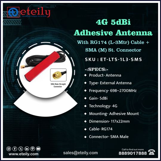
4G 5dBi #AdhesiveAntenna With RG174 (L-3Mtr) Cable + SMA (M) St. Connector
SKU: ET-LTS-1L3-SMS
-SPECS:-
• Product Antenna
• Type-External Antenna
• Frequency-698~2700MHz
• Gain- SdBi
• Technology-4G
• Mounting Adhesive Mount
• Dimension-117x22mm
• Cable-RG174
• Connector- SMA Male
Know More At - https://eteily.com/3-rf-antenna


#eteily#technologies#eteilyindia#rfantenna#5g#4g#external#telecom#telecomunication#india
#5G Outdoor Antenna#4G LTE Antenna#4G Internal Antenna#4G External Antenna#4G Outdoor Antenna#3G Antenna#3G Internal Antenna#3G External Antenna#3G Outdoor Antenna#2G/GSM Antenna#2G Internal Antenna#2G External Antenna#2G Outdoor Antenna#IoT Lora LPWAN#868MHz Antenna#433MHz Antenna#915MHz Antenna#925MHz Antenna#865MHz Antenna#GPS-GNSS ANTENNA
0 notes
Text
#rf antenna#eteily technology manufactures#eteily india#youtube#rf antenna manufacture#rf antenna india#rf antenna price#manufacturing#telecom#entrepreneur#gps antenna#gnss antenna
0 notes
Text

A mini GPS from uBlox with I2C and UART 🛰️📡🔧
The SAM-M8Q
is an entry-level 'all in one' GPS from uBlox - it comes with both UART and I2C interfaces plus a built-in antenna so it's ready to go 'out of the box.' It's also fairly small, so we decided to try and make a little breakout for it. It exposes both interfaces, but we expect most folks will like using the Stemma QT port for instant I2C interfacing. We gotta dig into uBlox's interface since we expect the I2C to be a little more complex than the PA1010 we've used.
#adafruit#gps#ublox#i2c#uart#sam-m8q#stemma#pa1010#electronics#gpsmodule#makerspace#hardwaredesign#embedded#opensourcetools#diyprojects#techinnovation#electronicsprojects#gpsbreakout#prototyping#smalldevices#sensorintegration#microcontroller#makersmovement
7 notes
·
View notes
Text
GPS/GNSS-referenced NTP (Network Time Protocol) server ensures precise time synchronization with high security and scalability. It provides accurate time distribution across networks while protecting against cyber threats and time manipulation. let us read this article penned down by the experts of one of the best GPS Antenna Suppliers.
0 notes
Text
Enhance Navigation Accuracy with Our GNSS Solutions in Dubai
The Global Navigation Satellite System (GNSS) has revolutionized the way we navigate and track locations across the globe. As a leading provider of GNSS solutions in Dubai, global navigation satellite system in dubai UAE UAE, we offer comprehensive services designed to improve navigation accuracy, ensuring seamless and reliable positioning for various industries and applications.
Understanding GNSS and Its Importance
GNSS is a satellite-based navigation system that enables users to determine their location, speed, and time data accurately. It comprises multiple satellite constellations, including GPS (United States), GLONASS (Russia), GALILEO (European Union), and BEIDOU (China). By leveraging signals from these satellites, GNSS receivers provide precise geospatial data essential for numerous sectors.
Why Navigation Accuracy Matters
Accurate navigation is crucial for industries that rely on precise positioning data. Whether it's transportation, construction, agriculture, or emergency response, improved navigation accuracy leads to better operational efficiency, enhanced safety, and improved decision-making. GNSS technology ensures that businesses and organizations can operate smoothly with real-time location data.
Our GNSS Solutions in Dubai, UAE
We specialize in delivering customized GNSS solutions tailored to meet the specific needs of our clients. Our services include:
1. High-Precision GNSS Equipment
We provide cutting-edge GNSS receivers, antennas, and related hardware to ensure reliable and accurate data collection. Our equipment is ideal for land surveying, mapping, and geospatial analysis, ensuring precision in all applications.
2. GNSS Signal Correction Services
To enhance accuracy, we offer real-time kinematic (RTK) and post-processing kinematic (PPK) solutions that minimize errors and provide centimeter-level precision. These services are essential for industries such as construction, mining, and agriculture, where accurate positioning is critical.
3. GNSS Software Solutions
Our advanced software tools are designed to interpret GNSS data efficiently. With powerful analysis features, businesses can gain insights into positioning, timing, and navigation data for improved decision-making.
4. Installation and Support
Our expert technicians provide professional installation services to ensure seamless integration of GNSS solutions with existing systems. We also offer ongoing technical support to ensure consistent performance and accuracy.
5. Consultation and Training
Our team of specialists offers consultation services to help businesses identify the best GNSS solutions for their operations. We also provide comprehensive training programs to ensure users maximize the benefits of GNSS technology.
Applications of Our GNSS Solutions
Our GNSS solutions serve a wide range of industries in Dubai and beyond, including:
Transportation and Logistics: Enabling fleet tracking and route optimization.
Construction: Ensuring precise site measurements and equipment positioning.
Agriculture: Facilitating precision farming practices for increased crop yield.
Marine Navigation: Ensuring accurate navigation and vessel tracking.
Emergency Services: Improving response times and location accuracy.
Why Choose Us for GNSS Solutions in Dubai?
Our expertise in GNSS technology, combined with a customer-centric approach, makes us the ideal partner for all your navigation accuracy needs. We prioritize innovation, reliability, and quality to deliver tailored solutions that empower businesses to operate efficiently.
For comprehensive GNSS solutions that enhance navigation accuracy in Dubai, UAE, contact us today. Our experts are ready to help you achieve precise positioning and improved operational performance.
1 note
·
View note
Text

Eteily Technologies India Pvt. Ltd.
GPS Marine Antenna With RG58 (L- 3MTR) Cable + N (F) St. Connector
SKU: ET-GPMR-2L3-NFS
For More Info - https://eteily.com/
#eteily#technology#eteilyindia#battery#manufacturers#telecom#fiberglassantenna#rf#antenna#GPS#marineantenna#connector#delhi
#gps tracker antenna#GPS Antenna manufacturers#gps gnss antenna#gps antenna#magnetic gps antenna#gps antenna design#GPS antenna#gps gsm antenna#external gps#gps antenna manufacturer#external gps antenna for android
0 notes
Text

GPS L2 1227.6MHz Active Adhesive Antenna
:SPECS:
1. TYPE: Adhesive Antenna
2. TECHNOLOGY GPS L
3. FREQUENCY: 76MHz
4. GAIN: 98dB-3dB
5. MOUNTING: Adhesive
6. CABLE TYPE: RG174
For More Info - 8889017888
Website - https://eteily.com/
#GPS-GNSS ANTENNA#gps gnss antenna in india#gps gnss antenna manufactures#GPS L1 GNSS Screw Mount Cabinet Antenna in india#gps gnss antenna suppliers in india#gps gnss antenna wholesalers in india#manufactures of gps gnss antenna#suppliers of gps gnss antenna#wholesalers of gps gnss antenna#gps gnss antenna in Ahmedabad#gps gnss antenna in delhi#gps gnss antenna in mumbai#gps gnss antenna in chennai#gps gnss antenna in bangalore#gps gnss antenna in bangaluru#gps gnss antenna in Hyderabad#gps gnss antenna in Kolkata#gps gnss antenna in Pune
0 notes
Text

The GPS PCB Active Patch Antenna is specifically engineered for L1 band applications at 1575.42 MHz. It incorporates a high-performance ceramic patch mounted on a PCB, complete with an integrated low-noise amplifier (LNA) to enhance signal strength. The antenna is supplied with a 1.13mm cable (10cm) and a UFL connector, facilitating seamless integration into compact GPS devices. Its dimensions are 15×15×4mm.
#rf antenna#rf antenna manufacture#telecom#rf antenna india#eteily technology manufactures#manufacturing
0 notes
Text
youtube
Desk of Ladyada - Triple Matrix Bonnet & u-blox UBX Vibes 🛰️🌍 https://youtu.be/jxZsDak93SY
This week Ladyada updates the TLV320DAC3100 design, developed a triple-matrix bonnet for Raspberry Pi 5 HUB75 RGB matrices, and successfully integrated a u-blox SAM-M8Q GPS module with UART/I2C and UBX interface, exploring GNSS modules with built-in antennas for quick prototyping.
#ladyada#raspberrypi#matrixbonnet#ublox#gpsmodule#electronics#pcbdesign#hardwarehacking#opensource#makers#tech#embedded#prototyping#adafruit#engineering#sam_m8q#hub75#raspberrypi5#rgbmatrix#nmea#ubx#iot#diytech#hardware#innovation#opensourcehardware#electronicsengineering#geek#techinnovation#Youtube
5 notes
·
View notes
Text
Precision Farming Market Expansion: Demand, Trends, and Key Players in 2024
Precision Farming Industry Overview
The global precision farming market size is anticipated to reach USD 24.09 billion by 2030, registering a CAGR of 12.8% from 2024 to 2030. Precision farming, also known as site-specific crop management or satellite farming, is a farm management concept that uses information technology to ensure optimum health and productivity of crops.
The precision farming technique largely depends on specialized equipment such as sensing devices, antennas and access points, and automation and control systems. It also includes maintenance and managed services. The process also incorporates a broad range of technologies such as bio-engineering, robotics and automation, imagery and sensors, and big data.
The growing number of applications for telematics in agriculture is anticipated to supplement the growth of the market. Telematics services include tracking devices that deploy the Global Navigation Satellite System (GNSS) to show the position of the equipment for management purposes. Major agriculture equipment manufacturers are adopting telematics services for their equipment to improve farm efficiency, thereby reducing the cost of agricultural operations and maximizing profitability. Improved management can also help reduce environmental impact.
Gather more insights about the market drivers, restrains and growth of the Precision Farming Market
Telematics technology is used to capture and transfer data from the farm equipment through sensors installed on tractors and other field monitoring equipment. The increasing adoption of telematics systems by agricultural equipment companies is expected to drive the growth of the market during the forecast period.
Furthermore, with GPS guidance and automation advancements, drones are poised to transform the agriculture industry in the forthcoming years. The ability of drones to precisely analyze the soil at the beginning of the crop cycle and detect a plant infected with bacteria or fungus is anticipated to propel the growth of the drone segment.
However, the low rate of technology adoption among farmers is likely to hamper market growth during the study period. This may be due to factors such as the absence of stringent standards and limitations on the exchange of data. Furthermore, farmers lack independent consulting and advisory services owing to the absence of validated agronomic models for Variable Rate Technology (VRT) to make decisions on investments. In addition, independent services are not linked to co-operatives, government bodies, and farmer associations where farmers can get additional information to make better decisions.
Browse through Grand View Research's Next Generation Technologies Industry Research Reports.
The global call center AI market size was valued at USD 2.00 billion in 2024 and is projected to grow at a CAGR of 23.8% from 2025 to 2030.
The global internet of medical things market sizewas estimated at USD 230.69 billion in 2024 and is projected to grow at a CAGR of 18.2% from 2025 to 2030.
Precision Farming Market Segmentation
Grand View Research has segmented the global precision farming market report based on offering, application, and region
Precision Farming Offering Outlook (Revenue, USD Million; 2017 - 2030)
Hardware
Automation & Control Systems
Drones
Application Control Devices
Guidance System
GPS
GIS
Remote Sensing
Handheld
Satellite Sensing
Driverless Tractors
Mobile Devices
VRT
Map-based
Sensor-based
Wireless Modules
Bluetooth Technology
Wi-Fi Technology
Zigbee Technology
RF Technology
Sensing Devices
Soil Sensor
Nutrient Sensor
Moisture Sensor
Temperature Sensor
Water Sensors
Climate Sensors
Others
Antennas & Access Points
Software
Web-based
Cloud-based
Services
System Integration & Consulting
Maintenance & Support
Managed Types
Data Types
Analytics Types
Farm Operation Types
Assisted Professional Types
Supply Chain Management Types
Climate Information Types
Precision Farming Application Outlook (Revenue, USD Million; 2017 - 2030)
Yield Monitoring
On-Farm
Off-Farm
Field Mapping
Crop Scouting
Weather Tracking & Forecasting
Irrigation Management
Inventory Management
Farm Labor Management
Precision Farming Regional Outlook (Revenue, USD Billion, 2017 - 2030)
North America
US
Canada
Mexico
Europe
UK
Germany
France
Russia
Italy
Asia Pacific
China
Japan
India
Australia
Singapore
South America
Brazil
Middle East and Africa (MEA)
Key Companies profiled:
Ag Leader Technology
AgJunction, Inc.
CropMetrics LLC
Trimble, Inc.,
AGCO Corporation
Raven Industries Inc.
Deere and Company
Topcon Corporation
AgEagle Aerial Systems Inc. (Agribotix LLC)
DICKEY-john Corporation
Farmers Edge Inc.
Grownetics, Inc.
Proagrica (SST Development Group, Inc.)
The Climate Corporation
Key Precision Farming Market Company Insights
Some of the key players operating in the market include Ag Leader Technology; AgJunction, Inc.; CropMetrics LLC; Trimble, Inc.; AGCO Corporation; Raven Industries Inc.; Deere and Company; Topcon Corporation; AgEagle Aerial Systems Inc. (Agribotix LLC); DICKEY-john Corporation; Farmers Edge Inc.; Grownetics, Inc.; Proagrica (SST Development Group, Inc.); The Climate Corporation among others.
Deere & Company is engaged in the manufacturing & construction of agricultural and forestry machinery; drivetrains and diesel engines for heavy equipment; and lawn care machinery. Additionally, the company also manufactures and provides other heavy manufacturing equipment. The company serves diverse industries such as agriculture, forestry, construction, landscaping & grounds care, engines & drivetrain, government and military, and sports turf.
AGCO Corporation is a U.S.-based agriculture equipment manufacturer. The company develops and sells products and solutions such as tractors, combines, foragers, hay tools, self-propelled sprayers, smart farming technologies, seeding equipment, and tillage equipment.
Prospera Technologies and Agrible, Inc. are some of the emerging market participants in the target market.
Porspera Technologies is a global service provider of agriculture technology for managing and optimizing irrigation and crop health. The company provides AI-based sensors and cameras that aid farmers in crop monitoring.
Agrible is a U.S.- based agriculture solution provider. The company helps customers in more than 30 countries optimize water use, crop protection, fertilization, fieldwork, research trials, food supply chains, and sustainability initiatives
Recent Developments
In July 2023, Deere & Company, a global agriculture and construction equipment manufacturer announced the acquisition of Smart Apply Inc. an agriculture technology solution provider. Deere & Company is focused on using Smart Apply’s precision spraying solution to assist growers in addressing the challenges related to regulatory requirements, input costs, labor, etc. The acquisition is expected to help the company attract new customers.
In April 2023 AGCO Corporation, a global agriculture equipment provider, and Hexagon, an industrial technology solution provider declared their strategic collaboration. The collaboration is focused on the expansion of AGCO’s factory-fit and aftermarket guidance offerings.
In May 2023, AgEagle Aerial Systems Inc., a global agriculture technology solution provider announced its establishment of a new supply agreement with Wingtra AG. The 2-year supply agreement is expected to securely supply RedEdge-P sensor kits for incorporation with WingtraOne VTOL drones.
In May 2021, AGCO announced a targeted spraying solutions strategic collaboration with Raven Industries Inc., BASF Digital, and Robert Bosch GmbH. The objective of this deal was to assess the targeted spraying technology for enhancing crop protection product applications by limiting crop input costs and addressing environmental sustainability.
Order a free sample PDF of the Precision Farming Market Intelligence Study, published by Grand View Research.
0 notes
Text
GPS splitters, also known as GNSS (Global Navigation Satellite System) splitters, allow multiple devices to share a single GPS signal from one antenna. Understand more explained by a supplier of NTP Timing Server.
0 notes
Text
GPS01-TD Module: A Comprehensive Solution for Quad-Mode GPS Positioning and Navigation
In today's rapidly evolving technological landscape, precise positioning capabilities have become a core requirement for various applications. The GPS01-TD module, as an advanced quad-mode GPS module, integrates multi-system compatibility supporting BDS/GPS/GLONASS/Galileo/QZSS/SBAS, with a special emphasis on fully supporting the BeiDou III signals. It provides users with a high-quality, interference-resistant, and low-power positioning and navigation solution. This module is not only technologically advanced but also environmentally friendly and energy-efficient, making it a rare high-performance GPS module choice in the market.
Multi-System Compatibility
The GPS01-TD module supports BDS/GPS/GLONASS/Galileo/QZSS/SBAS, allowing it to provide accurate positioning services globally with its quad-mode compatibility.
It fully supports BeiDou III signals, enhancing positioning accuracy and reliability in the Asia-Pacific region.

High Precision and Fast Positioning
The GPS01-TD module offers high-precision positioning with a tracking sensitivity of -163dBm and a cold start capture sensitivity of -147dBm, ensuring rapid positioning even in weak signal environments. It supports A-GNSS assisted positioning, enhancing startup speed and positioning accuracy.
Design Advantages
With a low-power design, the module is suitable for applications requiring long-term operation, reducing energy consumption and extending device lifespan. It also supports powering active antennas, enhancing signal reception capability and adapting to a wider range of external application needs.
Application Diversity
The module is suitable for personal positioning and navigation products like smartwatches and fitness trackers. It can be used for vehicle and maritime navigation, improving the safety and efficiency of transportation. In IoT devices, such as freight tracking and smart logistics, it provides real-time, accurate location data. Additionally, it is ideal for handheld portable devices like outdoor adventure gear and emergency response equipment, ensuring reliability in various environments.
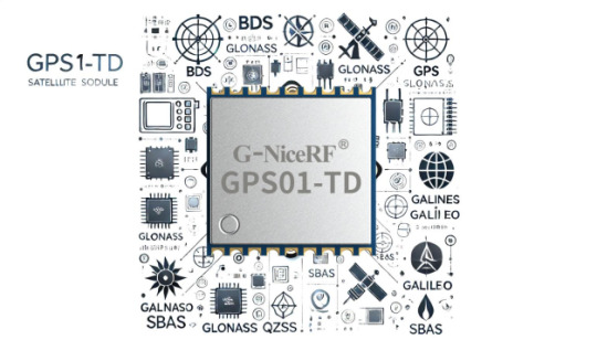
Strong Interference Resistance
The module employs advanced signal processing technology to enhance interference resistance, maintaining stable performance even in urban areas with tall buildings or complex natural environments.
Global Navigation Assurance
With its quad-mode system providing global coverage, the GPS01-TD module ensures continuous and accurate positioning services regardless of the country or region.
The GPS01-TD module showcases its competitive advantages as an advanced quad-mode GPS module in the market. Whether for commercial applications or personal use, the GPS01-TD offers an efficient and reliable positioning solution. By supporting BDS, GPS, GLONASS, Galileo, QZSS, and SBAS, it ensures seamless navigation services globally, with comprehensive support for BeiDou signals enhancing positioning accuracy and reliability worldwide. This module combines strong interference resistance with a low-power design, making it a highly popular choice for positioning and navigation solutions. Users can rely on the GPS01-TD module to provide continuous and accurate positioning services in complex environments, making it an ideal option for introducing precise and reliable global positioning support across various application fields.
For details, please click:https://www.nicerf.com/products/ Or click:https://nicerf.en.alibaba.com/productlist.html?spm=a2700.shop_index.88.4.1fec2b006JKUsd For consultation, please contact NiceRF (Email: [email protected]).
0 notes
Text
GPS Anti-jam System Demonstrated by Israel Aerospace Industries and Its Significance
Global Positioning System (GPS) has become an indispensable tool in modern warfare and military operations. However, with the widespread use of GPS, the risk of jamming and attack is also increasing. signal jammer Israel Aerospace Industries (IAI) first demonstrated its GPS Anti-jam System at the 2017 Bangalore Air Show in India, which is designed to protect the global navigation satellite system from jamming and attack. This article will explore the technical characteristics, application prospects and significance of this system in the global military and civilian fields. cell phone jammer
Technical characteristics of GPS Anti-jam System
Multi-channel Controlled Receive Antenna Technology
The GPS Anti-jam System demonstrated by Israel Aerospace Industries is based on multi-channel controlled receive antenna technology. This technology makes avionics systems immune to direct electronic attacks such as GPS jammers through multiple antenna arrays and advanced digital processing units. The system is only the size of a laptop, which is easy to install and use on various platforms.GPS jammer
Advanced signal processing methods
The system uses the most advanced signal processing methods to resist jamming by using a multi-channel method. The project manager pointed out that this technology is currently the most advanced anti-jamming method in the world and can effectively counter various forms of GPS jamming. The system is designed not only to GPS, but also to block interference with global navigation satellite systems (GNSS), including Europe's Galileo, Russia's GLONASS and China's BeiDou.
Flexible integration and upgrade capabilities
The system can be integrated on any sea and air platform to meet the diverse needs of customers. IAI also provides different packaging solutions for future customers to meet miniaturization needs. In addition, the system is highly flexible and upgradeable. Users only need to make slight software changes when using the next generation of coded transmission methods to effectively counter future interference threats.
Application prospects
Military field
In the military field, the application prospects of GPS anti-interference systems are broad. As early as during the Iraq War in 2003, the Iraqi military successfully used GPS jammers to interfere with more than 100 precision-guided weapons of the US military. The anti-interference system demonstrated by IAI this time can effectively enhance the combat capabilities of various countries' armies in complex electronic environments and ensure the reliability of navigation and precision strikes.
Civilian field
In the civilian field, GPS anti-interference systems also have important applications. For example, in the fields of aviation, navigation, transportation, etc., GPS navigation systems are key technologies. The introduction of this system can improve the safety and reliability of these areas and prevent accidents and losses caused by interference.
Global market demand
Indian demand
The GPS anti-jam system displayed by Israel Aerospace Industries at the Bangalore Air Show is aimed at India's needs. During the Kargil conflict between India and Pakistan in 1999, the United States unilaterally shut down GPS services to the India-Pakistan region, causing losses to India. India has been seeking to ensure satellite guidance solutions, including the establishment of its own global satellite navigation system. The introduction of this system can help India improve the anti-jam capability of its navigation system and enhance national security.
Global market potential
Israel Aerospace Industries estimates that the sales of this system and its related product portfolio will reach hundreds of millions of dollars in the next three to five years. This shows that the demand for anti-jam systems in the global market is increasing rapidly. With the widespread application of global satellite navigation systems, the demand for anti-jam technology in various countries will continue to grow.
Conclusion
The GPS anti-jam system displayed by Israel Aerospace Industries at the Bangalore Air Show in India represents the latest progress in anti-jam technology for global navigation satellite systems. The system not only has advanced technical characteristics and broad application prospects, but also can meet the growing needs of the global market. In the future, with the continuous advancement of technology and the expansion of the market, GPS anti-interference systems will play an increasingly important role in the global military and civilian fields.
0 notes
Text
Indoor Positioning and Navigation Market - Forecast(2024 - 2030)
Indoor Positioning and Navigation Market Overview:
The global Indoor Positioning and Navigation market was valued at $6.92 billion in 2017 and is projected to grow to $23.6 billion in 2023 at a CAGR of 27.9%. Developed countries in North America and Europe remain the largest market for Indoor Positioning and Navigation Systems sales which accounts for a major share in the global market. The USA is a major market in for Indoor Positioning and Navigation in Americas accounting around 40% share in the global market. The market in the USA was valued at $2.78 billion in 2017 and is anticipated to grow to $9.58 billion in 2023 at a CAGR of 28.1%. In the Asia Pacific, China and Japan are the major contributors in this market. The market in the Asia Pacific is rapidly growing owing to the increased penetration and growing applications of indoor positioning and navigation in aviation, healthcare, logistics etc., at a CAGR of 31.8% and it is expected to reach $7.52 billion by 2023. The European market is expected to reach $8.75 billion in 2023 growing at a CAGR of 25.6%. The growing applications of indoor positioning and navigation systems and consumer demands are driving the market in Europe. UK holds the largest share in the European market for indoor positioning and navigation which accounts around 25% share in its market and Germany comes next to the UK with a share around 21% in the European Indoor Positioning and Navigation Market.
Indoor Positioning and Navigation Market Outlook:
Indoor positioning and navigation systems are based on technologies like Magnetic Positioning, Simultaneous Localization and Mapping (SLAM), Global Navigation Satellite System (GNSS), Global Positioning System (GPS), Global Navigation Satellite Systems (GLONASS), Galileo, A-GPS, Cellular Sensors (Gyroscope, Acceleration, Barometer, Antenna and Near Field Communication (NFC)), Wi-Fi, Ultra-Wide Band (UWB), Radio-frequency identification (RFID) and Bluetooth Low Energy (BLE) Beacons. The major applications of these technologies include positioning & navigation (contextual information, modelling, surveying and mapping of infrastructures), location-based promotion, asset tracking (personnel and object tracking in an infrastructure escalating real-time monitoring and management) and emergency services (navigation to locate people in case of emergencies during disaster management or law enforcement situations).
In the verticals of this Indoor Positioning and Navigation Market, aviation industry uses these technologies for passenger navigation to designated lounges, baggage tracking, emergency and other airport-related services. Advertising industry includes geo-fencing, location-based promotions and other applications related to E-commerce and digital retail. Healthcare uses RFID, Wi-Fi in hospitals to navigate patients to desired wards. Logistics uses these technologies for automating inventory control and asset tracking in warehouses. The transportation industry has many applications of these technologies in railway stations navigating to ticket counters, inquiry counters, lounges, ATMs etc. Tourism Industry uses these technologies in Hotels for navigating tourists to rooms, lounges, receptions, parking lots and many other places. The automotive industry uses these technologies for vehicle identification and tracking, quality control in production or asset management.
Indoor Positioning and Navigation Market report comprises of pricing analysis for different types of Indoor Positioning and Navigation. The average pricing of indoor positioning and navigation tags which use RFID technology is estimated at $3 and that of tags using Wi-Fi technology is $40. Pricing of indoor positioning and navigation systems also depends on the range covered. For covering an area of 50,000 sqft is estimated to be costing around $5300 and that of covering 100,000 sqft is $10,200.
Request Sample
Indoor Positioning and Navigation Market Growth Drivers: One of the main drivers in the global Indoor Positioning and Navigation Market is the growing adaption of these technologies many industries like healthcare, logistics etc. There is a high return on investment using these technologies as using these indoor positioning and navigation technologies will result in low operational costs thereby maximizing efficiency and profit.
Indoor Positioning and Navigation Market Challenges: One of the major challenges in the global Indoor Positioning and Navigation Market is security and privacy concerns of using these technologies. The major privacy concern is the collection and sharing of data with third party companies.
Indoor Positioning and Navigation Market Research Scope:
The base year of the study is 2017, with forecast done up to 2023. The study presents a thorough analysis of the competitive landscape, taking into account the market shares of the leading companies. It also provides information on unit shipments. These provide the key market participants with the necessary business intelligence and help them understand the future of the Indoor Positioning and Navigation market. The assessment includes the forecast, an overview of the competitive structure, the market shares of the competitors, as well as the market trends, market demands, market drivers, market challenges, and product analysis. The market drivers and restraints have been assessed to fathom their impact over the forecast period. This report further identifies the key opportunities for growth while also detailing the key challenges and possible threats. The key areas of focus include the types of Indoor Positioning and Navigation market and their specific applications in different types of vehicles.
Inquiry Before Buying
Indoor Positioning and Navigation Market Report: Industry Coverage
Indoor Positioning and Navigation Market Technologies: Magnetic Positioning, Simultaneous Localization and Mapping (SLAM), Global Navigation Satellite System (GNSS), Global Positioning System (GPS), Global Navigation Satellite Systems (GLONASS), Galileo, A-GPS, Cellular Sensors (Gyroscope, Acceleration, Barometer, Antenna and Near Field Communication (NFC)), Wi-Fi, Ultra-Wide Band (UWB), Radio-frequency identification (RFID) and Bluetooth Low Energy (BLE) Beacons.
Applications of Indoor Positioning and Navigation Technologies: Navigation & Positioning, Location Based Promotion, Geo-Fencing, Asset Tracking, Emergency Services and Others
Schedule a Call
Indoor Positioning and Navigation Market Platforms: Android, iOS and others.
Verticals in Indoor Positioning and Navigation Market: Aviation, Healthcare, Education, Transportation, Logistics, Automotive, Advertising, Tourism and others.
Indoor Positioning and Navigation market report also analyzes the major geographic regions for the market as well as the major countries for the market in these regions. The regions and countries covered in the study include:
North America: The U.S., Canada, Mexico
South America: Brazil, Venezuela, Argentina, Ecuador, Peru, Colombia, Costa Rica
Europe: The U.K., Germany, Italy, France, The Netherlands, Belgium, Spain, Denmark
APAC: China, Japan, Australia, South Korea, India, Taiwan, Malaysia, Hong Kong
The Middle East and Africa: Israel, South Africa, Saudi Arabia
Indoor Positioning and Navigation Market Key Players Perspective:
Some of the key players mentioned in this report are Google, Qualcomm, Microsoft, Samsung, Cisco, Apple, Here Holdings, Hewlett Packard, INSITEO, AeroScout Industrial among others.
Buy Now
Indoor Positioning and Navigation Market Trends:
Google is developing an indoor location positioning technology based on its Tango Augmented Reality (AR) system. This new technology is called Visual Positioning Service (VPS). It will allow a mobile device to swiftly and accurately understand its position indoors. Using visual clues from distinct features in the room, a Tango-enabled phone would be able to recognize where it is in space by comparing new points captured by its camera with previously observed ones.
January 24, 2018: Here Technologies, a mapping company valued at around $3 billion has acquired Micello, a company based in California that operates a platform for creating, editing and publishing indoor maps. This acquisition will support HERE’s strategy to provide world-class mapping and advanced location services both indoors and outdoors. In combination with HERE’s unique tracking technologies, indoor maps will enable new and innovative market solutions such as the tracking of parts on a factory floor, the optimization of workspace usage, indoor wayfinding at complex transit interchanges, and last mile guidance in vehicles.
Fantasmo, a notable technology start-up, has camera positioning standard (CPS) which captures spatial data through your device’s camera. With this data stored in a server, AR apps can readily and accurately determine position and location relative to recognized landmarks in the immediate vicinity. Fantasmo’s approach also mirrors another startup, 6D.ai, whose platform can capture a dense 3D mesh with smartphone cameras while running in the background.
Sydney airport introduces Apple Maps. Getting around Sydney Airport just got easier due to the gateway’s adoption of Apple Maps (web mapping service), which shows users how to navigate their way through T1 International, T2/T3 Domestic terminals and its car parks. Customers can now easily find facilities and services inside the terminal, including restrooms, parent’s rooms, elevators and shops, and see current location with indoor positioning.
Infsoft 360° Antennas’ Angle of Arrival technology has spurred a new way about how to calculate location. These receiver antennas detect the radio signals emitted by any mobile 2.4 GHz transmitter (e.g. beacon) that is in range. Based on the angle and distance determined, it is possible to calculate the position of an object equipped with such transmitter with an accuracy of 1 to 3 meters. This makes server-based BLE solutions a favorable alternative to cost intensive Ultra-wideband (UWB) applications as long as no centimeter accuracy is required. In comparison to using UWB, a beacon based tracking system utilizing AoA technology can be set up at much lesser costs and also has an advantage of a longer battery lifetime. Practical applications of this technology can include tracking systems in logistics, for example, which can make a decisive contribution to maximizing warehouse operations.
#indoor positioning market#indoor navigation market#location based promotions#geo-fencing#asset tracking#emergency services#navigation market#indoor positioning market size#Localization#Mapping
0 notes