#Curiosity Martian panorama
Explore tagged Tumblr posts
Text
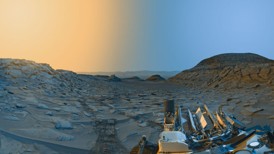
Curiosity Rover postcard from Mars' Marker Band Valley

NASA’s Curiosity Mars rover used its navigation cameras to capture panoramas at two times of day on April 8, 2023, at 9:20 AM and 3:40 PM local Mars time, then merged the two images together. Blue represents the morning panorama and yellow the afternoon.
Each of these new panoramas took about 7-1/2 minutes to capture and include five individual images stitched together. By capturing the panoramas at two different times of day, the scene shows dramatic shadows similar to stage lighting coming in from the left and right of center stage. Because it was winter (when dust is at its lowest in the Martian atmosphere) at the time, shadows are sharper and deeper.

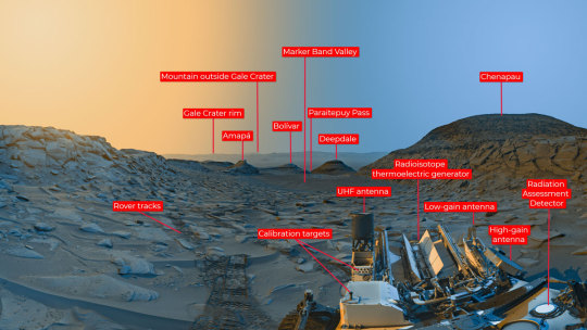
(Some annotated details from the scene.)
Curiosity is ascending the foothills of Mount Sharp, a 3-mile-tall (5km) mountain found within Gale Crater. The crater rim is visible roughly 25 miles (40 km) away. And because skies were so clear, you can see a mountain beyond the crater rim, even though it’s 54 miles (87 kilometers) outside of Gale.
NASA source page: X
11 notes
·
View notes
Text
Buenas Noches...
/Good Evening...
/Bonne Nuit...
/Gute Nacht...
(Panorama de la superficie marciana tomada por el rover Curiosity
/Panorama of the Martian surface taken by the Curiosity rover
/Panorama de la surface martienne pris par le rover Curiosity
/Panorama der Marsoberfläche mit dem Rover Curiosity
- Kosmo Es - Telegram)
0 notes
Link
A recent study published in Nature examines how mud cracks observed on Mars by NASA’s Curiosity rover could provide insight into how life on the Red Planet could have formed in its ancient past. On Earth, mud cracks have traditionally been linked to cycles of wet and dry environments that assisted in developing the complex processes responsible for microbial life to take hold. This study was conducted by an international team of researchers and holds the potential to help scientists better understand the geological and chemical processes that might have existed in Mars’ ancient past, up to billions of years ago. “This is the first tangible evidence we’ve seen that the ancient climate of Mars had such regular, Earth-like wet-dry cycles,” said Dr. William Rapin, who is a CNRS Research Scientist at IRAP (Institut de Recherche en Astrophysique et Planétologie), and lead author of the study. “But even more important is that wet-dry cycles are helpful – maybe even required – for the molecular evolution that could lead to life.” For the study, the team analyzed images of mud cracks obtained from NASA’s Mars Curiosity rover, currently traversing Gale Crater on Mars, between sols 3154 to 3156 (June 20-22, 2021) when it was drilling in a rock nicknamed “Pontours”. The images reveal distinct T- and hexagonal-shaped cracks within the surface, which is indicative of many cycles of wet and dry conditions that once existed in this region. Wet conditions, such as flowing rivers or lakes, are responsible for producing the mud, but when that same mud dries out, it compresses and cracks, resulting in the broken surface we see today. For context on sols, one Martian sol equals one day on Mars, which is just under 40 minutes longer than one day on Earth. Zoomed in portion of the panorama image obtained by the Curiosity rover’s Mastcam at the rock target “Pontours” which unveils hexagonal patterns (red outlines in the same image, right) that propose these mud cracks were produced over a multitude of wet-dry cycles occurring over many years. (Credit: NASA/JPL-Caltech/MSSS/IRAP) “These exciting observations of mature mud cracks are allowing us to fill in some of the missing history of water on Mars,” said Dr. Nina Lanza, who is principal investigator of the ChemCam instrument onboard NASA’s Curiosity rover, and a co-author on the study. “How did Mars go from a warm, wet planet to the cold, dry place we know today? These mud cracks show us that transitional time, when liquid water was less abundant but still active on the Martian surface.” The study’s findings indicate that these cracks are indicative of a transition of minerals, notably smectite clays to sulfate-bearing strata, which potentially indicates that Mars experienced an Earth-like environment during the Noachian-Hesperian transition, or 3.8 to 3.6 billion years ago. On Earth, smectite clays and sulfate-bearing strata are typically associated with aqueous environments. Also, like Earth, the Red Planet’s geologic history is divided into time periods from oldest to youngest, with those time periods being the Pre-Noachian, Noachian, Hesperian, and Amazonian and each lasting approximately from 4.5 to 4.1 billion years ago, 4.1 to 3.7 billion years ago, 3.7 to 2.9 billion years ago, and 2.9 billion years ago to the present, respectively. A panorama image taken by NASA’s Curiosity Mars rover shows a rock target nicknamed “Pontours” where researchers identified preserved, ancient mud cracks hypothesized to have shaped throughout lengthy cycles of wet and dry environments over many years. These cycles are hypothesized to support conditions where life could form. (Credit: NASA/JPL-Caltech/MSSS/IRAP) While Mars is presently an extremely cold and dry planet that’s inhospitable for life as we know it, scientific evidence suggests things were much different billions of years ago when it first formed. This was when liquid water flowed into lakes, rivers, and oceans while volcanoes spewed gases to keep the atmosphere thick enough for this liquid water to keep cascading across the surface. Auroras danced across the sky from the solar wind interacting with the Red Planet’s magnetic field, much like we see on Earth today. But while these Earth-like conditions might have led to microbial life forming on Mars, these conditions weren’t meant to last. Artist illustration of an ancient ocean on Mars, which researchers have hypothesized contained more water than Earth’s Arctic Ocean and that the Red Planet has lost almost 90 percent of that water to space. (Credit: NASA/GSFC) Over millions of years, the interior of Mars began to cool due to its small size—half of Earth—resulting in the decreasing temperature of its molten liquid outer core which gradually reduced its geological and magnetic influence on the Red Planet. The volcanoes stopped spewing gases and the magnetic field dissipated, taking the auroras with it. Along with this, protection from the solar wind was also lost, resulting in the latter slowly stripping the planet’s atmosphere, leading to evaporation of all liquid water. In the end, Mars is the barren world we see today, without a drop of liquid water on its surface. What new discoveries will scientists make about Mars and its ancient past in the coming years and decades? Only time will tell, and this is why we science! As always, keep doing science & keep looking up! The post Ancient Cracked Mud Found on Mars appeared first on Universe Today.
0 notes
Text
NASA's Curiosity Captures Martian Morning and Evening in New 'Postcard'
El Curiosity de la NASA captura la mañana y la tarde marcianas en una nueva ‘postal’ Créditos: NASA/JPL-Caltech El rover Curiosity Mars de la NASA usó sus cámaras de navegación en blanco y negro para capturar panoramas de “Marker Band Valley” en dos momentos del día el 8 de abril. Se agregó color a una combinación de ambos panoramas para una interpretación artística de la escena. Se combinó la…

View On WordPress
0 notes
Text
NASA's Curiosity rover snaps extremely detailed 'postcard' of Martian landscape after waking up from a 'brain-boosting nap'
The new panorama snapped by NASA's Curiosity rover combines photos from two different times of day to create a highly detailed image of the Red Planet. from Livescience https://www.livescience.com/space/mars/nasas-curiosity-rover-snaps-extremely-detailed-postcard-of-martian-landscape-after-waking-up-from-a-brain-boosting-nap via IFTTT
0 notes
Text
NASA Curiosity Rover Sends Home New Photo as it Climbs Martian Slope
[ad_1]

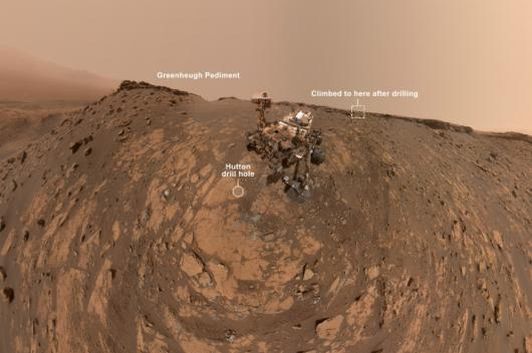
The ‘Martian selfie’ taken by NASA Curiosity rover, stitched together from 86 photos. (Photo: NASA/JPL)
After its epic 1.8-gigapixel panorama of the desolate Martian surface, Curiosity scaled a 31-degree slope of the Greenheugh Pediment before taking this photo.
News18.com
Last Updated: March 25, 2020, 12:42 PM IST
NASA’s Curiosity rover has sent us yet another…
View On WordPress
#Curiosity#Curiosity Mars panorama#Curiosity Mars rover#curiosity mars selfie#Curiosity Martian panorama#Curiosity rover#curiosity rover landing#curiosity rover selfie#curiosity selfie#curiosityselfie#handshake nasa mars#martian selfie#nasa#nasa curiosity#NASA Curiosity Rover#nasa mars#nasa mars 2020#NASA Mars 2020 Rover#nasa mars landing#NASA Mars Mission#NASA Mars photo#nasa mars rover
0 notes
Text
NASA Curiosity Rover has Sent Us a Stunning 1.8-Gigapixel Panorama Photo of Mars
[ad_1]

A section of the 1.8 billion-pixel panorama shot by the NASA Curiosity rover, overlooking Glen Torridon on Mars. (Photo: NASA-JPL)
The Mars photograph shot by Curiosity is the highest resolution ever of its kind, showing a desolate, dystopian world that may have once held life.
News18.com
Last Updated: March 11, 2020, 7:15 PM IST
NASA’s Curiosity rover has…
View On WordPress
#Curiosity Mars panorama#Curiosity Martian panorama#Mars gigapixel photograph#Mars panorama#Mars photo#Mars photograph#mars photographs#mars surface#Martian surface#nasa#NASA Artemis Mission#nasa curiosity#NASA Curiosity Rover#NASA Mars photo#NASA Perseverance#New Mars photo#Photo of Mars
0 notes
Photo

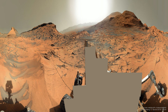
Mars Panorama 360 from Curiosity : Which way up Mount Sharp? In early September, the robotic rover Curiosity continued its ascent up the central peak of Gale Crater, searching for more clues about ancient water and further evidence that Mars could once have been capable of supporting life. On this recent Martian morning, before exploratory drilling, the rolling rover took this 360-degree panorama, in part to help Curiosity's human team back on Earth access the landscape and chart possible future routes. In the horizontally-compressed featured image, an amazing vista across Mars was captured, complete with layered hills, red rocky ground, gray drifting sand, and a dusty atmosphere. The hill just left of center has been dubbed Maria Gordon Notch in honor of a famous Scottish geologist. The current plan is to direct Curiosity to approach, study, and pass just to the right of Gordon Notch on its exploratory trek. via NASA
316 notes
·
View notes
Photo

Curiosity's 1.8-Billion-Pixel Panorama of the Martian surface via /r/spaceporn https://ift.tt/2PJxjrO
0 notes
Photo

2021 September 14
Mars Panorama 360 from Curiosity Image Credit: NASA, JPL-Caltech, MSSS; Processing & License: Elisabetta Bonora & Marco Faccin (aliveuniverse.today)
Explanation: Which way up Mount Sharp? In early September, the robotic rover Curiosity continued its ascent up the central peak of Gale Crater, searching for more clues about ancient water and further evidence that Mars could once have been capable of supporting life. On this recent Martian morning, before exploratory drilling, the rolling rover took this 360-degree panorama, in part to help Curiosity's human team back on Earth access the landscape and chart possible future routes. In the horizontally-compressed featured image, an amazing vista across Mars was captured, complete with layered hills, red rocky ground, gray drifting sand, and a dusty atmosphere. The hill just left of center has been dubbed Maria Gordon Notch in honor of a famous Scottish geologist. The current plan is to direct Curiosity to approach, study, and pass just to the right of Gordon Notch on its exploratory trek.
∞ Source: apod.nasa.gov/apod/ap210914.html
46 notes
·
View notes
Text

See NASA’s Curiosity Rover’s Stunning 360-Degree View Atop “Mont Mercou” on Mars
NASA’s Curiosity Mars rover took this 360-degree panorama while atop “Mont Mercou,” a rock formation that offered a view into Gale Crater below. The panorama is stitched together from 132 individual images taken on April 15, 2021, the 3,090th Martian day, or sol, of the mission. The panorama has been white-balanced so that the colors of the rock materials resemble how they would appear under daytime lighting conditions on Earth.
The rover’s Mast Camera, or Mastcam, provided the panorama. Malin Space Science Systems in San Diego built and operates Mastcam. A division of Caltech, NASA’s Jet Propulsion Laboratory in Southern California built the Curiosity rover and manages the Curiosity rover for the agency’s Science Mission Directorate in Washington.
8 notes
·
View notes
Photo

Mars Panorama 360 from Curiosity Which way up Mount Sharp? In early September, the robotic rover Curiosity continued its ascent up the central peak of Gale Crater, searching for more clues about ancient water and further evidence that Mars could once have been capable of supporting life. On this recent Martian morning, before exploratory drilling, the rolling rover took this 360-degree panorama, in part to help Curiosity's human team back on Earth access the landscape and chart possible future routes. In the horizontally-compressed featured image, an amazing vista across Mars was captured, complete with layered hills, red rocky ground, gray drifting sand, and a dusty atmosphere. The hill just left of center has been dubbed Maria Gordon Notch in honor of a famous Scottish geologist. The current plan is to direct Curiosity to approach, study, and pass just to the right of Gordon Notch on its exploratory trek. September 14, 2021 via Space https://ift.tt/3htPpvZ
2 notes
·
View notes
Photo

Curiosity's 1.8-Billion-Pixel Panorama of the Martian surface
54 notes
·
View notes
Text
While Stargazing on Mars, NASA's Curiosity Rover Spots Earth and Venus
NASA - Mars Science Laboratory (MSL) patch. June 15, 2020 NASA's Curiosity Mars rover occasionally stops to stargaze. Recently, it captured a shot of Earth and Venus in the Red Planet's night sky.
Image above: Two images of the night sky were combined to show Earth and Venus as seen by NASA's Curiosity Mars rover on June 5, 2020, the mission's 2,784th Martian day, or sol. The planets appear as pinpoints of light owing to a combination of distance and dust in the air. Mars' Tower Butte is visible at bottom. Image Credits: NASA/JPL-Caltech. Curiosity aimed its Mast Camera, or Mastcam, at the heavens about 75 minutes after sunset on June 5, 2020, the 2,784th Martian day, or sol, of the mission. A two-image twilight panorama reveals Earth in one frame and Venus in the other. Both planets appear as mere pinpoints of light, owing to a combination of distance and dust in the air; they would normally look like very bright stars. The brief photo session was partly to gauge the twilight brightness: During this time of year on Mars, there's more dust in the air to reflect sunlight, making it particularly bright, said Mastcam co-investigator Mark Lemmon of the Space Science Institute in Boulder, Colorado. "Even moderately bright stars were not visible when this image of Venus was taken," Lemmon said. "Earth also has bright twilights after some large volcanic eruptions."
Mars Science Laboratory (MSL). Animation Credits: NASA/JPL-Caltech
When Curiosity's Mastcam imaged Earth and its Moon in 2014, the color and brightness of the sky were significantly different than from these most recent images because of all the high-altitude dust in the Martian air right now. At the bottom of the new images is the top of a rock feature called Tower Butte in the "clay-bearing unit," which Curiosity has been exploring for more than a year. Since landing in 2012, the rover has captured blue Martian sunsets and passing asteroids as well as Mercury and Mars' two moons, Phobos and Deimos, transiting across the Sun. Related articles: Quick Detour by NASA Curiosity Checks Ancient Valley and Rover Views Serene Sundown on Mars https://orbiterchspacenews.blogspot.com/2015/05/quick-detour-by-nasa-curiosity-checks.html Mercury Passes in Front of the Sun, as Seen From Mars https://orbiterchspacenews.blogspot.com/2014/06/mercury-passes-in-front-of-sun-as-seen.html NASA Rover Gets Movie as a Mars Moon Passes Another https://orbiterchspacenews.blogspot.com/2013/08/nasa-rover-gets-movie-as-mars-moon.html More information about Curiosity: https://mars.nasa.gov/msl/home/ https://nasa.gov/msl https://www.nasa.gov/mission_pages/msl/index.html Image (mentioned), Animation (mentioned), Text, Credits: NASA/Tony Greicius/Grey Hautaluoma/Alana Johnson/JPL/Andrew Good. Greetings, Orbiter.ch Full article
17 notes
·
View notes
Photo

Hills Ridge e uma panorâmica marciana a bordo do jipe Curiosity. . The Hills Ridge and a Martian landscape on board of Curiosity hover. . Credit: NASA/T. Appéré . #nasa #mars #marte #hills #montes #curiosity #landscape #panorama #jipe #rover #tracks #trilha #picoftheday #instagood #astronomy #astronomia #astrogram #apod #jpl https://www.instagram.com/p/B7yVArKJCEP/?igshid=i0uqfg5owfnd
#nasa#mars#marte#hills#montes#curiosity#landscape#panorama#jipe#rover#tracks#trilha#picoftheday#instagood#astronomy#astronomia#astrogram#apod#jpl
36 notes
·
View notes
Video
youtube
Curiosity Mars Rover Snaps 1.8 Billion-Pixel Panorama
This panorama showcases "Glen Torridon," a region on the side of Mount Sharp that Curiosity is exploring. The panorama was taken between Nov. 24 and Dec. 1, 2019, when the Curiosity team was out for the Thanksgiving holiday. Since the rover would be sitting still with few other tasks to do while it waited for the team to return and provide its next commands, the rover had a rare chance to image its surroundings several days in a row without moving.
Composed of more than 1,000 images and carefully assembled over the ensuing months, the larger version of this composite contains nearly 1.8 billion pixels of Martian landscape.
13 notes
·
View notes