#62km
Text


🚴♀️☀️🤍
1 note
·
View note
Text
Located 62km north-east of the capital Manila, Daraitan village in Rizal province is home to about 5,700 residents, a majority of whom are members of the Dumagat-Remontado indigenous people who consider vast hectares of the mountain range as part of their ancestral domain.
But the village may soon disappear under the same waters that give it life, once the Philippine government finishes building the Kaliwa Dam – one of 16 flagship infrastructure projects of former president Rodrigo Duterte that is being funded by China.
The new dam is expected to provide Metro Manila with an additional 600 million litres of water daily once it is finished by end-2026. Officials said building the 60m-high reservoir is even more necessary now that the country is starting to feel the impact of the El Nino weather phenomenon.
But it was only in 2021 under Mr Duterte that construction finally broke ground, three years after Manila and Beijing signed the 12 billion peso (S$288 million) loan agreement.
Of the 119 on the list [of flagship projects of the "Build, Build, Build” infrastructure programme], Mr Duterte turned to China to finance 16 big-ticket projects in a bid to cement his legacy by the time his presidency ended in 2022. He embraced Beijing during his term and even downplayed Manila’s claims in the disputed South China Sea in favour of securing loans and grants from China.
Analysts have criticised Mr Duterte’s infrastructure programme as ambitious. Perennial domestic issues like local politics, right-of-way acquisition problems, lack of technology and red tape in bureaucracy led to severe delays in the projects.
The same issues hound the China-funded projects – which come under Beijing’s Belt and Road Initiative (BRI) to build infrastructure in developing nations – with the problems made more severe by Beijing’s high interest rates in its loan agreements and local backlash due to displacement of residents or potential environmental damage.
Critics say the BRI has been detrimental in the long run to some recipient countries, especially those that have been unable to repay their loans, like Sri Lanka and Zambia.
The Duterte government’s failure to take advantage of its BRI loans was a “missed opportunity” for the Philippines, said infrastructure governance specialist Jerik Cruz, a graduate research fellow at the Massachusetts Institute of Technology.
The four completed China-funded projects under Mr Duterte were controversial too. But they came to fruition because they had the support of local politicians allied with Mr Duterte and therefore increased his political capital, said Dr Camba.
Tribal leaders said they were not properly consulted regarding the project that threatens their traditional way of life. Environmentalists from the Stop Kaliwa Dam Network also say the project would destroy 126 species of flora and fauna in the Sierra Madre.
The Philippines’ Indigenous Peoples’ Rights Act states that the government must first secure a tribe’s free, prior and informed consent before building on its ancestral lands.
But Ms Clara Dullas, one of the leaders of the Dumagat-Remontado in Rizal, alleged that the Duterte government had either misinformed or pressured other tribe members into giving their consent.
She could not bear to hold grudges, though, noting that the Dumagat-Remontado organisations that eventually agreed to the Kaliwa Dam were each given 80 million pesos, or $1.9 million, in “disturbance” fees.
“The Kaliwa Dam is the reason why our tribe is divided now. There is a crack in our relationships even if we all come from the same family,” said Ms Dullas. “I can’t blame the others because we lack money. I believe there was bribery involved.”
The government requires them to present identification documents, and only those given passes may enter. Mr Dizon said this is to ensure that no unidentified personnel enter the area [close to the construction zone].
“We feel like we are foreigners in our own home because the Chinese and the people in our own government are now preventing us from entering the lands where we grew up,” said tribe leader Renato Ibanez, 48.
Mr Ibanez also accuses the Philippine authorities of harassing tribe members who are vocal against Kaliwa Dam. Some of them have been accused of working with communist rebels, a charge the tribe vehemently denies.
Unlike his predecessor, Mr Marcos is more aggressive in defending Manila’s overlapping claims with Beijing in the South China Sea, but still fosters economic ties with it.
Geopolitical tensions between the two nations and Mr Marcos’ stance towards Beijing are going to dictate the fate of the pending China-funded projects the President inherited from Mr Duterte, said Mr Cruz.
Tribe members said they would be more amenable if Mr Marcos would revisit Japan’s proposed Kaliwa Intake Weir project that Mr Duterte had set aside.
“We like Japan’s proposal. It would not destroy our forests. It would not affect residents here. The Philippines would not be buried in debt,” said Ms Dullas.
This was among the alternatives the Dumagat-Remontados offered during their nine-day march in February 2023, when some 300 members walked 150km from Quezon and Rizal all the way to Manila to protest against the Kaliwa Dam.
But they failed to secure an audience with Mr Marcos. They remain wary of the President’s position on the Kaliwa Dam and other controversial China-funded deals.
“As much as we want to fully pin our hopes on him, we don’t. We’ve learnt from past efforts to trick us, make us believe a project is about to end, only for it to be resurrected again years later,” said Ms Dullas.
2024 Mar. 3
#philippines#indigenous rights#dumagat-remontado#state violence#red tagging#infrastructure#environmental issues#afp-pnp
57 notes
·
View notes
Text

my boss letting me know friday afternoon i need to deliver flowers to ontario 62km away tomorrow morning
9 notes
·
View notes
Text
Leadville Trail 100 Run
Nel reportage che scriverò sul viaggio negli Stati Uniti di quest'anno non dirò nulla della mia gara, ma siccome volevo scrivere comunque qualcosa lo faccio qui, almeno per ricordarmi cosa è successo.
Ho passato il giorno prima della gara steso nel bagagliaio della GMC che avevamo noleggiato, ho dormito qualche ora e verso il tramonto abbiamo lasciato il paese e siamo andati a dormire a Turquoise Lake, sul percorso. La mattina la sveglia era dannatamente presto, alle 2:30am perché la gara partiva alle 4:00, il classico orario del cazzo delle gare americane. Abbiamo parcheggiato al liceo, in fondo alla 6th St. e siamo arrivati alla linea di partenza quando era ancora deserta. Un tipo aveva acceso un fuoco sul marciapiede appena fuori casa e se ne stava lì a bere il caffè con un plaid sulle gambe guardando i corridori infreddoliti cercare di scaldarsi. Ho bevuto un caffè nell'unico locale aperto, una gelateria messicana che quel giorno ha chiuso il bilancio di un anno. Nella caffetteria c'era anche Dean Karnazes, che dal vivo sembra anche più scemo che in foto. La partenza è figa, si respira tensione e si sente già puzza di morti ancora prima di partire, ma come col sudore non capisci mai se sei tu o è quello a fianco.
Da Leadville a Hope Pass
È la mia terza 100 miglia ma la cosa non mi dà nessuna fiducia: ho sentito tanto la quota nei giorni precedenti e non sono affatto sicuro di essermi acclimatato. Sono nervoso. Cerco Brent e Natalie ma non li vedo, ascolto l'inno. Poi vedo una nuvola di polvere da sparo, e solo dopo sento il colpo. La prima salita è a un quarto di miglio dalla partenza ma non la sento, ho già fatto 400 metri e mi restano solo 159,6 chilometri di gara. In fondo alla Sesta si volta a sinistra sul Boulevard, poi il gruppo si allunga e si costeggia il lago. Davvero una bomba, cazzo mi sento Anton Krupicka. Sarò in centocinquantesima posizione e va bene così. La aid station di May Queen è una bomba e non sono preparato al volume del tifo. Trovo un gruppetto col mio ritmo e arrivo in controllo ad Outward Bound, con la prima salita della gara alle spalle. Outward Bound è in mezzo alla prateria ed è pieno di gente, non trovo Elisa e perdo un po' di tempo ma sono al 38esimo chilometro in meno di quattro ore di gara quindi cerco di restare tranquillo. Uscito dalla aid station, che è lunghissima, cerco le cuffiette e metto un po' di fottuto country. Inizio ad avere le gambe stanche verso Halfpipe, circa al 45esimo chilometro a memoria. Mi fermo a fare pipì e riparto. C'è un gruppetto di gente che corre bene, due tipi un po’ swag corrono insieme e si danno i cambi: penso che prima o poi salterò ma intanto provo a stargli dietro. In salita camminano lentissimi, poi fanno degli scatti improvvisi, sul tecnico si piantano, ammesso che ce ne sia, sulle discese corribili si lanciano in picchiata: corrono tutti in modo insensato. Passo a Twin Lakes (62km) in meno di sette ore, dopo aver visto i due specchi d'acqua turchesi dominati dalle montagne del Sawatch Range. La aid station è indescrivibile, ricorda Les Contamines a UTMB ma piena di gazebo e di gente che griglia come il giorno del Super Bowl. Mi rifornisco, prendo i bastoncini e lascio le borracce a mano e parto col mio amico francese di cui ho dimenticato il nome verso Hope Pass. Lui è un fottuto francese ma in salita non va molto forte. Il sentiero è più duro di quanto mi aspettassi ma la valle è bellissima e sembrano le Alpi. Sopra alla Timberline ci sono dei Lama e un accampamento di tende su cui rifornirsi. Gli ultimi tornanti fino al passo, che ho visto mille volte nei video, sono massacranti ma arrivo in cima un'ora e mezza dopo aver lasciato Twin Lakes. Ho una fitta sotto alle costole e non riesco a correre in discesa: è un pezzo tecnico, a tutti gli effetti e fanculo a chi dice il contrario. Il versante di Winfield è molto ripido e sebbene siano solo 850 metri di dislivello te li fa maledire tutti. In fondo alla discesa c'è un tratto molto lungo e poco corribile in leggera salita fino al giro di boa e solo qua inizio a incontrare i primi che iniziano a tornare indietro.

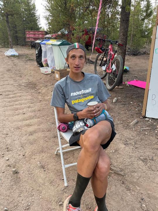
At the top of Hope Pass, 3800m above sea level
Da Winfield ad Half Pipe: scavando nel profondo, quasi
Non vedo Rob Krar, che trovo alla aid station seduto su una roccia a guardare chi passa. Si è ritirato e mi dispiace, glielo dico e lui mi incoraggia. Alla aid station ci sono dei ragazzi e delle ragazze super gentili che portano ai corridori quello di cui hanno bisogno senza farli alzare da dove si trovano. Mi propongono diverse cose ma non ho voglia di niente, così mi alzo, vado in bagno, prendo l'ultima benedizione da Rob Krar e me ne vado. Mi giro per tornare a Leadville dopo 10 ore e mezza. Mi scende una lacrima, ma devo correre ancora 80 chilometri, sono appena a metà, non è finita. Riparto da Wienfield comunque meglio di come ci sono arrivato. Fa caldissimo e il sole dei tremila metri è caldo. Ritorno per la seconda volta alla quota più alta in cui sia mai stato in vita mia nemmeno tre ore dopo averla lasciata: Hope Pass, 3800 dannati metri sul livello del mare. La salita è massacrante, vado lentissimo ma supero tutti e nessuno mi supera. Sono un fottuto europeo dopo tutto, camminare in salita è l'unica cosa che so davvero fare. Su tira vento e sono stanco e c'è Leadville sul fondo, e sembra vicina ma la strada è ancora lunga. Alla fine di questa discesa mi mancheranno soltanto 60 chilometri di strade bianche corribili, e finalmente troverò Lapo, il mio dannato pacer.
In discesa ho i quadricipiti andati e le fitte continuano a torturarmi ma riesco a correre a un ritmo decente. Quando entro a Twin Lakes, in 13 ore e 4 minuti, sono passato in 40esima posizione, ho 12 ore per fare 60 chilometri per avere la fibbia grande, potrei anche camminare fino all'arrivo e probabilmente ce la farei comunque: la gara sta andando dannatamente meglio del previsto, la parte tosta è alle spalle, ma manca sempre una maratona e mezza, e la dannata notte. Elisa è all'inizio della aid station ad aspettarmi e Lapo è pronto a petto nudo, esattamente come l'ultima volta che ci siamo visti, in mezzo al deserto, un anno prima. "Tu non preoccuparti per come mi vesto io, preoccupati di cosa ti devo portare". Gli smollo tutto: zaino, borracce, frontali, bastoncini. Ripartiamo e sulla salita di Mt Elbert riprendiamo quattro persone: in salita vado più di chiunque altro ma restano solo 1000 metri di dislivello, non molti per fare la differenza, insomma, devo correre. Quando inizia la discesa mi ritrovo piantato, non riesco a correre continuativamente e lentamente diventa un'agonia. Lapo mi impone di alternare corsa a camminata e così in qualche modo arriviamo ad Half Pipe. C'è un signore con un cappellino da camionista che va su e giù per il percorso con una bici elettrica. Dice qualcosa, non ricordo cosa ma mi fa sorridere. Poi Lapo mi porta un bicchiere di caffè che mi rimette al mondo. Cristo mi ero dimenticato di quanto è buono. Capisco che il caffè è la chiave per arrivare in fondo, riparto confortato verso Outward Bound, so che è vicino.

Lapo and me at the Halfpipe aid station, km 115
Da Halfpipe a Leadville: inizia la gara
Siamo immersi nell'oscurità, intuisco la distanza dalla aidstation di Outward Bound, sperduta in mezzo alla prateria. Da qualche miglio corriamo sempre con le solite persone: la seconda donna, il numero 267 e il mio tipo francese. Tutti con relativi pacer, francese escluso. Non stiamo bene ma nessuno ci supera e non superiamo nessuno, ho l'impressione che siamo rimasti soltanto noi in gara. Arriviamo ad Outward Bound e io sembro essermi ripreso. "Ti do tempo fino alla cima di Sugarloaf Pass per convincerti che stai bene" mi ordina Lapo, "da là cambiamo marcia e ti tiro fino all'arrivo". Signorsì, io d'altronde sono lucido ma ho smesso di pensare lasciando a lui anche questo ingrato compito. Non ho mai avuto un pacer e lui non l'ha mai fatto, ma mi trovo bene e insieme formiamo una bella squadra: lui mi parla per tenermi cosciente, io non rispondo ma sono contento di ascoltarlo. Alla aidstation c'è la Eli, chiacchieriamo un po', mi cambio, bevo un altro caffè. Ripartiamo correndo e raggiungiamo in fretta Fish Hatchery e poi l'attacco della salita di Powerline: è dannatamente dritta, una fila di frontali fa intuire dove finisce. Mancano 34 chilometri all'arrivo e inizio ad averne i coglioni pieni, così faccio quello che so fare meglio, finalmente: abbasso la testa e mi metto a sbacchettare. Cristo se sbacchetto: passo uno, due, tre, cinque, dieci atleti. Stacco di qualche metro persino Lapo che resta a una ventina di metri da me. Non avendo nulla da ascoltare inizio a imbambolarmi e gli occhi iniziano a chiudermi, se rallentassi mi arenerei così continuo a spingere: mancano ancora tanti chilometri ma non c'è più nulla per cui salvare le gambe, insomma, è il momento di andare, e al diavolo tutto il resto.
Alla aid station di Sugarolaf c'è un rave party in miniatura: la aid station è avvolta da una nuvola di erba e ci sono musica e luci stroboscopiche. Un tale fa delle bolle di sapone giganti, sarà mezzanotte. Bevo l'ultimo caffè e ripartiamo per l'ultima discesa verso Mayqueen. In discesa ho ancora male ai quadricipiti ma Lapo mi costringe a correre. Quando il sentiero diventa più tecnico ritrovo la gioia di correre in discesa e supero qualche altro atleta incartato tra le radici: sono davvero degli incapaci. Entriamo alla aid station di May Queen e Lapo mi precede di un po'. Quando arrivo al ristoro non mi siedo, ho voglia di ripartire. C'è una lavagnetta bianca appoggiata per terra con sopra scritti dei nomi. Chiedo alla ragazza cosa siano e lei mi dice che sono i passaggi. Solo quelli? Faccio un rapido conto e sono in 26esima posizione: non sono mai stato così davanti in una 100 miglia. Vedo la lavagnetta e mi ricordo che sono in gara, che per una volta potrei anche provare a fare qualcosa di meglio che correre contro me stesso e cercare di superare attivamente qualcuno. Ringrazio e riparto, Lapo mi sta dietro, io imposto un ritmo attorno ai 5' al chilometro, dopo 120 chilometri di corsa per me è un ritmo incredibile. Non ho più male, sono caldo, se mi fermo muoio. Corro. Il sentiero di Turquoise Lake è al buio come la prima volta che ci sono passato, non c'è niente da guardare, tanto vale correre e correre ancora. Corro e a un certo punto mi accorgo che dietro di me Lapo è scomparso. Cazzo. Non ho acqua, la frontale si sta scaricando e mi mancano 15 chilometri. Nel frattempo supero due persone, chiedo una borraccia a una, una frontale all'altra. Continuo a correre. I chilometri passano, il tempo vola. 14, 13, 12. Passo il campground in cui ho dormito la notte precedente, imbocco il Boulevard, trovo il mio amico francese che cammina a bordo strada, gli dico di seguirmi ma mi dice di andare. Continuo a correre. Quando imbocco il Boulevard, a 5 chilometri dall'arrivo, c'è una fila di cartelli a bordo strada, a una distanza precisa uno dall'altro, che riportano i nomi dei vincitori della gara dal 1983 ad oggi: sei stanco sai ancora fare i conti e sai anche che prima di arrivare di quei dannati cartelli dovrai superarne 39. Così inizio a contarli, trovo davanti a me un ultimo corridore, lo supero accelerando: corro in salita, corro sul Boulevard, tre chilometri prima di finire Leadville Trail 100 Run. Sono sulla 6th, vedo l'arco d'arrivo, delle persone che applaudono. Gli ultimi metri sono in salita, fanno male, ma io sto bene: sono sempre stato bene. Spengo l'orologio. Marilee mi abbraccia, mi dà una medaglia, Ken appoggia il fucile, mi abbraccia anche lui. Mi siedo sotto all'arco di arrivo, insieme a loro, resto lì per un po'. Poi arriva Lapo, arriva Elisa. Bevo una cioccolata, prendo la dannata fibbia, poi andiamo a dormire, è stata una lunga giornata, ma, in fondo, non è poi stata così lunga.
7 notes
·
View notes
Text
I just got back home guys.
I went cycling to another town which was like 62km of cycling, it took me 5 fucking hours, my face hurts because I’m sunburnt as fuck and my thighs are crying for help.
If i won’t die tomorrow, I’m immortal
4 notes
·
View notes
Text
홍콩 기상청 태풍 야기(Yagi) 8호 경보 상향 발령
(홍콩=데일리홍콩) 김한국 기자 = 홍콩 기상청이 오후6시20분을 기해 태풍 야기(Yagi)에 대한 경보를 3호 경보에서 8호 경보 단계로 상향 발령하였다.
태풍 야기(Yagi)로 인하여 바람이 63-117km/h 속도로 지속적으로 불며 최대 180km/h이 넘는 풍속을 기록하기 시작했다는 판단 때문이다.
홍콩에서 태풍 3호 경보는 평균 풍속이 41-62km/h, 최대 풍속 110km/h 이 넘는 경우 발령되며 8호 경보는 평균 풍속이 63km/h를 넘어 최대 180km/h 이상이 예상될 경우에 발령된다.
홍콩 기상청은 현재의 8단계 경보가 적어도 내일 정오까지는 유지될 것이라고 하여 내일 대부분의 화이트 칼라 직장인들은 아침 출근이 생략될 전망이다.
제11호 태풍 야기(Yagi) 이동 예측도,…
0 notes
Text
MoTRD and SDF Celebrate Upgrades to Berbera-Burao Road, Inaugurate Next Phase of Construction Sheikh-Berbera
#Somaliland celebrates upgrade of 62km #Berbera-#Burao Road & inaugurates next phase of construction from #Sheikh to Berbera. The project will boost trade, create 1,000+ jobs & generate income for local businesses. @SDFSomaliland @SomalilanDmotrd
#Berbera#Bridge#Burao#Ministry of Transport and Roads Development (MOTRD)#Roads#Sheikh#Somaliland Development Fund (SDF)#Transport#Transport Corridors#Transportation
0 notes
Text
Everest View Trek
If you are looking for a short trek and get an awesome view of Mount Everest, then Himalayan Masters has one for you. You can book a luxurious 7-day trek with us. Enjoy the picturesque village and high-class lodges during the trek with stunning views of the world’s highest peak and other high mountain peaks in the vicinity of Khumbu. A perfect trek for those short on time and budget, and have a journey of a lifetime with Everest View Trek.
Highlights of Everest View Trek
A thrilling flight to Lukla (one of the highest-altitude airports in the world).
Trek to Hotel Everest View for a panoramic view of the Everest, Nuptse, Ama Dablam, and other high peaks.
Experience local Tibetan culture, even try their clothes during the festive season.
Enjoy the remoteness of Everest with comfort and luxury without any pain like other long treks such as Manaslu Circuit Trek, Upper Mustang Trek, Kanchenjunga Circuit Trek, etc.
Explore and soak in the diverse vegetation of Sagarmatha National Park.
Everest View Trek Itinerary
Day 1: Arrive at Kathmandu
Day 2: Fly to Lukla and trek to Phakding
Day 3: Trek to Namche Bazar
Day 4: Trek to Everest View Hotel and Khumjung Village and Back to Namche Bazar
Day 5: Trek to Lukla from Namche Bazar
Day 6: Fly to Kathmandu
Day 7: Departure
Duration: 7 days
Distance: appx. 62km
Highest Altitude: Everest View Hotel (3,880m)
Everest View Trek Cost: $980 per person
0 notes
Text
ダイエットログ025
冒頭のここに書く面白エピソードを忘れてしまった! 思い出せないっwww
Work
まあワイやったらできるやろ…(なんも分からんけど)
なんかこう、研究生をサポートしています!と表向きには表現していますけど、実質は用心棒であるので、プロジェクト進行において発生しうるインシデントに対して、えっ、わ、ワイが行くんで? うぉおおおおお!!!
【相\(^o^)/殺】という任務を遂行しています。
ここでいうインシデントは、プロジェクトの進行を妨げる技術的な要素の事で、人員不足・予算の問題・技術や日程の不一致などで発生します。
なのでですね、こういった正常値を外れて現れるインシデントを、「フフフ…ワシに任せておけい…(心は半泣き)」とか言って、まじでゼロからググり始める(最近はAIに聞いてる)ところからスタートするのを繰り返すので、だいたいいつも、一回Lv0になってスライムとゴブリンにボコボコにされるんですよ、お助けくだせえよ…でもまあワイやったらできるやろ…やるか、よっしゃやったろ。またワイの持ち技が一つ増えてしまいますなあ?ガッハッハ!
っていう強い心が必要で、今日もかなり消耗してたんですけどなんか心が救われましたという話は後述します。
Fig. 01 モーターのスイッチを入れるとOSが落ちる機械の発明

FuraIT #57、凄い良かった…
前述の試練イベント発生などあり、心理的に結構ド緊張していたのですが、結果的にFuraITに救われました。参加できて凄い良かった。
何が良かったのかな
前回もそうでしたが、オンライン参加の我々と現地にいる皆とが、出来るだけ乖離しないようにコミュニケーションが取り続けられていて、その結果離れた場所から参加しながらもその場に一緒に居られた感が発揮されていたようにおもいます。会場側もそうだったなら、ちょっと嬉しいですな。
FuraITの皆さんの参考になるようなお話をするぞって意気込んでいた訳ですが、実際のところ須藤さん鴇田さんの話を聴いているうちに、参考にさせて頂いているのは僕の方だったかーと感銘を受けました。まさにちょうど昨日、研究生と話してた内容が、我々ギークキッズを受け入れてくれるような社会環境がまだまだこの土地にはないですよねー、どうしたらいいんだろという内容だったのでした。
楽しみにしてたくろさんの話は、偶然にも今日の心境に刺さりまくりで、応援に来てたつもりが救われてしまってました。流れて来た問題を未然にキャッチして解決する役割はゼロスタートが多かったりするし、大成功よりも頓挫を防ぐ成果を求められていたりするしなので、というか、まあ自分の心境はいいか。これまでは役割を持った状態で会話することが多かったので、初めて普通に参加者としてお話が聴けてとても新鮮でした。かなりの贔屓目になってる気がしつつ、くろさんホント凄いなって改めて感じました…凄いっていう表現は怒られそうですけど。初見の人にそれは大丈夫なのかっていう感じの眠さを見せてて笑ってしまったので、畑仕事の後はちゃんと休息していますように。あと、ぷぷさんと絵文字でハイタッチしようとしたら、間違えてVサインを送ってしまい、異文化交流みたいで面白かったです。
なんか凄いFuraITをべた褒めしてしまっていますが、子供の頃にこういう場所に出会えていたらな、という理想形に近い場所の一つだとおもいました。
これは小さくてもCoderDojoを続けている動機のひとつでもあったりします。そして、僕にはその理想形が実現できていないので、ちょっとだけ悔しいぜという気持ちもあるからなのでした。でも僕が実現する必要は無いのでw、こういう場所が増えていくなら、協力していきたいですなー。
Diet
2024-06-13 木
歩数:3153
徒歩:2km
エアロバイク:1時間 62km
朝食:グラノーラ+低脂肪乳
昼食:チョココロネ、炊き込みご飯おにぎり
夕食:グラノーラ+豆乳
間食:どら焼き、カフェラテ
体重:61.7kg
体脂肪率:20.8
内臓脂肪:9.0
エアロバイクを漕ぎながら日記を書いています。今日はゆっくりめで1時間62km。なんか計測値がバグってて2400キロカロリーを消費してたことになってて、消費しててくれ〜とおもったりしました。
Fig. 02 これはランチです

Fig.03 これはDiscord参加前にド緊張してて、半分しか食べられなかったどら焼きです

あっ、今週献血行けんかった、月末ごろかな。
0 notes
Text
"KALAMMAWADI DAM: Experience the best of Kolhapur"

The Kalammawadi Dam is one of the biggest dams located in the beautiful district of Kolhapur. Built on the Dudhaganga river near Radhanagari Taluka, the Kalammawadi Dam is bestowed with nature’s blessings through its beautiful landscape. The backdrop of this dam is a total feast to one’s eyes. The beauty of this great dam might leave you mesmerized.
HISTORY OF THE DAM:
The ownership of the dam lies in the hands of the Government of Maharashtra. The dam was constructed between 1983-1999. The Kalammawadi Dam was inaugurated by the late Prime Minister of India, Indira Gandhi. The length of the dam is 4200 feet while the height of the dam above the lowest foundation level is 240 feet. It is surrounded by a thick forest cover. The name of the dam is placed after the goddess Kalamma Devi whom the people worship as their deity.
SIGNIFICANCE OF THE DAM:
The Kalammawadi Dam has its importance in many ways. It is selected as an important Hydropower station. It is also utilized for irrigation purposes to boost the production of crops. Many villages on the bank of the Dudhaganga river use the dam water for domestic purposes also. The dam also helps in fighting droughts and controlling floods. The Kalammawadi Dam is also home to Indian Gaur, the endangered bison. With a water storage capacity of 28 thousand million cubic meters, the ambiance around the dam is completely rich in its diverseness.
HOW TO REACH:
The Kalammawadi Dam is very well connected by roads, air, and railways that can help you reach this beautiful place of beauty and royalty. The best time to visit this place is within the monsoon months of July to September when the dam is in its maximum flow. The most effective timing from 10 AM to 6 PM. Visitors ideally spend half an hour visiting Kalammawadi Dam.
By Air - The dam is best accessible from Kolhapur district and one can reach there by a flight and the dam is just 62kms away from the airport.
By Train - The nearest railway station is the Kolhapur railway station. It is approximately 56 km away from this place.
By Road - The dam is near major highways. And thus you can also come here through your cab or any of the booked private cab services. It is around 59 km by bus route.
THINGS TO DO:
The city is dotted with some sightseeing places like Shri Mahalakshmi Temple, also known as the “Dakshin Kashi”. A must-visit tourist attraction in this city is the New Palace Museum which offers the visitors a combination of Hindu and Jain influence in its architecture. The bungee jumping experience has also been set up amidst the stunning Kolhapur landscape.
CONCLUSION:
Every nature lover must undoubtedly visit this place at least once. Being situated in Kolhapur, it attracts the tourists' eye. Travel enthusiasts living near Kolhapur usually make a single-day trip to have a fun-filled, enriching, and joyful experience of the Kalammawadi Dam.
0 notes
Text
身内に甘過ぎないか?警察官が62km/hオーバー!一般道をバイクで時速112キロ巡査部長摘発 和歌山県警は8月に処分も公表せず https://dougarider.com/archives/120267
0 notes
Text
Thông tin tỉnh Sóc Trăng: bản đồ, mã bưu chính, mã vùng, mã tỉnh - VinaMap
Sơ lược về tỉnh Sóc Trăng - Sóc Trăng là một đơn vị hành chính cấp tỉnh, có vị trí thuộc vùng Đồng bằng sông Cửu Long. Tỉnh này buổi đầu được thành lập vào ngày 1/1/1900 theo Nghị định của Toàn quyền Đông Dương. Sau nhiều lần tái nhập, Sóc Trăng chính thức được tái lập vào tháng 04/1992. Sóc Trăng là một đơn vị hành chính cấp tỉnh, có vị trí thuộc vùng Đồng bằng sông Cửu Long. Tỉnh này buổi đầu được thành lập vào ngày 1/1/1900 theo Nghị định của Toàn quyền Đông Dương. Sau nhiều lần tái nhập, Sóc Trăng chính thức được tái lập vào tháng 04/1992. Sóc Trăng có tọa độ địa lý 9°36′ Bắc và 105°54′ Đông, cách thành phố Hồ Chí Minh 231km và thành phố Cần Thơ 62km. Sóc Trăng có tọa độ địa lý 9°36′ Bắc và 105°54′ Đông, cách thành phố Hồ Chí Minh 231km và thành phố Cần Thơ 62km. Tỉnh này có vị trí tiếp giáp với 4 tỉnh trong nước và biển Đ - 16kvpi2gmq
https://vinamap.net/tinh-soc-trang

0 notes
Text


Phang Rat rivermouth, the border between Rayong and Chanthaburi province.
Today's 62km cycle ride - 20 September 2023.
0 notes
Text


End of the road at Paknam Phang Rat campground, the river is the border of Chanthaburi and Rayong provinces.
A 62km cycle ride, 32C with 'realfeel' of 40C.
1 note
·
View note
Text
Green Limousine – Xe Hà Nội Vĩnh Phúc Tốt Nhất 2023
Hành trình từ Hà Nội đi Vĩnh Phúc vào khoảng 62km, thời gian di chuyển khoảng 1 giờ 30 phút khi đi qua ĐCT05 với rất nhiều nhà xe cao cấp và chất lượng. Dưới bài viết này hãy cùng Dixere tìm hiểu về nhà xe Green Limousine Hà Nội đi Vĩnh Phúc cao cấp 2023.
Xem thêm: https://dixere.vn/green-limousine.html


0 notes
Last Seen Blogs

crumpchy
Sleeby

galactic-glossolalia
Dragonair at Heart


foeto-blog
「Enter... Pandemonium!」

instinctpc-blog
Instinct-PC