
Anglocelt, Briton, Britannophile, Europhile, European Colonialist, British Nationalist, European Ultranationalist, White Supremacist, White Nationalist, Semi-constitutional Monarchist, Sexist, Racist, Misogynist, Male Chauvinist, Anti-suffragist, British Unionist, Capitalist, Anti-immigrationist, Remigrationist, Identitarian, British Citizen, Commonwealth Citizen, Xenophobe, Negroephobe, Mahometanophobe, Transphobe, Loyal first to King Charles III and his future successors; second to my noble lord; Lady Camilla Osborne; and ultimately to the British Empire and the Anglo-Celtic race, 24M. Nationalism will save the world. I don't mind reserved homosexualists. This is my second account, the first one was terminated. God Save the King! 🇬🇧🇫🇷🇪🇺🇺🇸🇷🇺 "The greatest enemy of knowledge is not ignorance, it is the illusion of knowledge." -Sir Stephen William Hawking CH, CBE, FRS, FRSA "It is impossible for a man to learn what he thinks he already knows." -Epictetus "The British Empire is, under Providence, the greatest instrument for good that the world has ever seen." -The Most Honourable George Nathaniel Curzon, 1st Marquess Curzon of Kedleston KG, GCSI, GCIE, PC, FRS, FRGS, FBA, Prime Minister of the United Kingdom
Don't wanna be here? Send us removal request.
Statistics
We looked inside some of the posts by w-r-pitt and here's what we found interesting.
Average Info
Notes Per Post
4K
Likes Per Post
3K
Reblog Per Post
852
Reply Per Post
41
Time Between Posts
8 hours
Number of Posts By Type
Text
2
Photo
15
Last Seen Tumblr Blogs


Fun Fact
Tumblr has 411 employees.
Text
Maps of Twenty-five Obscure British Colonial Territories:
1. British Sphere of Influence in Siam (Zone of influence of the United Kingdom; Agreed upon with France, Siam's only other neighbouring state besides Britain) (15 Jan 1896 - 14 Jul 1925):
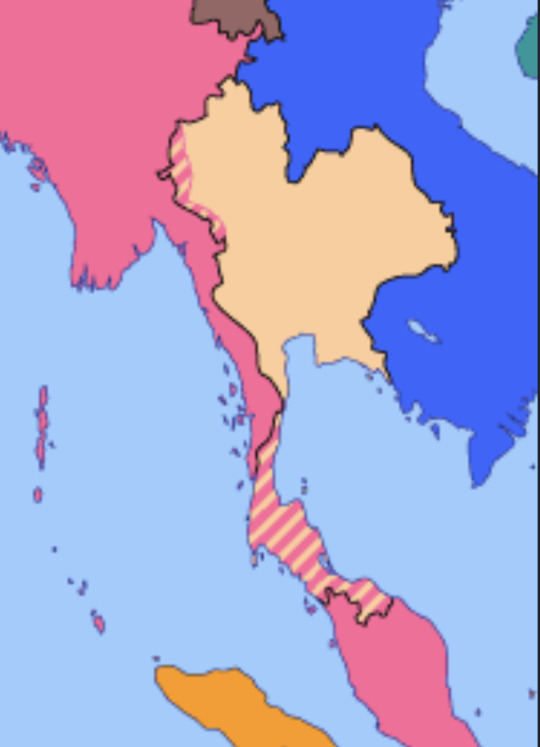
Source of map:
https://omniatlas.com/maps/southern-asia/19250512/plain/
2. Mombaza (Protectorate of the United Kingdom) (9 Feb 1824 - 25 Jul 1826):

Source of map:
https://crouchrarebooks.com/browse/a-manuscript-chart-of-mombasa/
3. Adamawa Emirate (Emirate of Yola) (Subordinate to the Sokoto Caliphate, which was under British control; legally part of German Kamerun) (1897 - at least 1915):
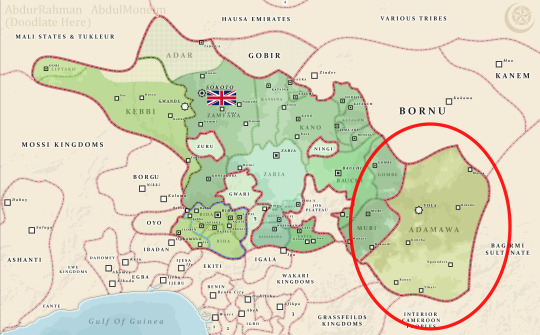
Source of map:
https://commons.wikimedia.org/wiki/File:Sokoto_Sultanate.png
4. Corinto (Cirinto, Cobinto) (Administered occupied territory of the United Kingdom) (13:00 27 April 1895 - 5 May 1895):
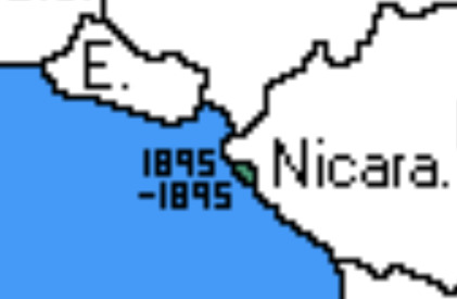
Source of map:
https://imgur.com/phDUNur
5. Hyder (Village in the United States that is partially integrated into the Dominion of Canada) (20th century - Present):
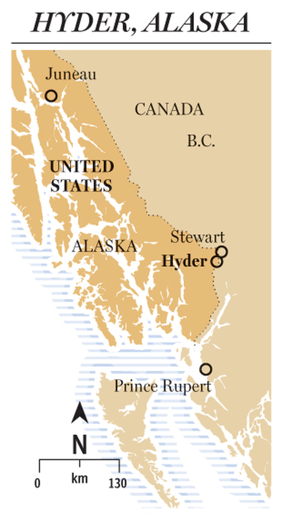
Source of map:
https://nationalpost.com/news/canada/folks-living-in-this-tiny-outpost-on-the-alaskan-border-may-use-canadian-dollars-but-theyre-still-100-american
6. King Edward VII Plateau (Formally claimed for the United Kingdom by Sir Ernest Henry Shackleton CVO OBE FRGS FRSGS on 9 Jan 1909):

Source of map:
https://www.loc.gov/item/2002624045/
7. British Concession of Chinde (British Concession in Portuguese Mozambique; Subordinate to the Nyasaland Protectorate; Abandoned in 1923) (1 Jan 1892 - 22 Jul 1925):
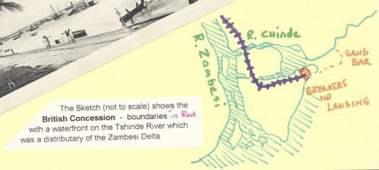
Source of map:
https://www.spink.com/lot/21127001647#
8. Holy Roman Empire (Ruled by Richard of Cornwall, prince and native of the Kingdom of England) (13 January 1257 - 2 April 1272):

Source of map:
https://commons.wikimedia.org/wiki/File:Mitteleuropa_zur_Zeit_der_Staufer.svg
9. State of Brazil (Dejure colony of the British Protectorate of the Kingdom of Portugal and the Algarves) (1808 - 1815):

Source of map:
https://www.panmythica.com/2008/04/mapas-histricos-do-brasil.html
10. Thibet (Defacto British Protectorate) (Late nineteenth century - 1948):
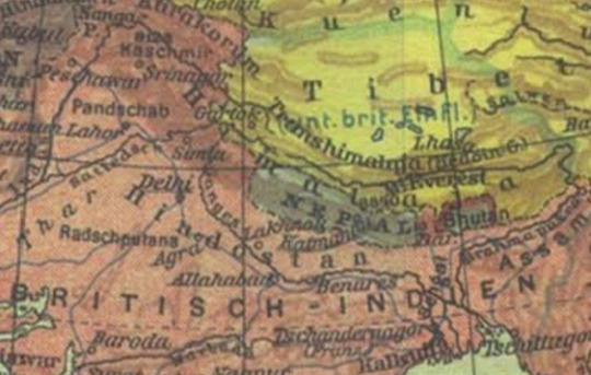
Source of map:
https://epdf.pub/queue/soldaten-atlas.html
11. Territory of Ruanda-Urundi (Ruled from London by the Belgian Government-in-exile) (Oct 1940 - Sep 1944):

Source of map:
https://commons.wikimedia.org/wiki/File:LocationRuandaUrundi.png
12. United Kingdom of Chishingaland (Self-proclaimed British Protectorate) (At least 2018 - Present):

Source of map:
https://www.tumblr.com/w-r-pitt/773650293226422272/the-united-kingdom-of-chishingaland-british?source=share
13. British Zone of Influence in Arabia (29 Jul 1913 - 1949?):
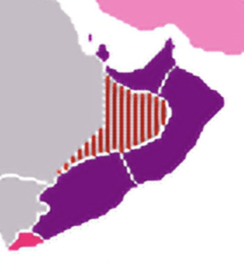
Source of map:
https://commons.wikimedia.org/wiki/File:British_Empire_Anachronous_4.PNG
14. Saudi Arabia Protectorate (Defacto British Protectorate under the Treaty of Darin) (26 Dec 1915 - 20 May 1927):

Source of map:
https://drive.google.com/file/d/1qTeIlZFNc9S2McO-cP8cwDWT2LPC6lcA/view
15. Sheikh Othman (South Arabia) (Mission field of the Church of Scotland) (1890s? or 1900s?):

Source of map:
https://commons.wikimedia.org/wiki/File:Map_of_Church_of_Scotland_Mission_Fields,_late_19th_century_(imp-cswc-GB-237-CSWC47-LS2-001).jpg
16. British Zone of Influence in China (11 Feb 1898 - 1912?):

Source of map:
https://www.deviantart.com/tondoempireball/art/Spheres-of-Influence-in-China-1901-910968862
17. Hansi Rajanate (Sovereign state, unaffiliated with the United Kingdom, ruled independently by the Briton George Thomas) (1798 - 1801):

Source of map:
https://archive.org/details/in.ernet.dli.2015.281766/page/n119/mode/2up
18. Chumbi Valley (Formal British zone of occupation in the Great Qing) (7 Sep 1904 - 8 Feb 1908):
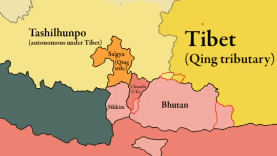
Source of map:
https://youtu.be/48wkBskmYnE?si=N34P_1tPkScfC15b
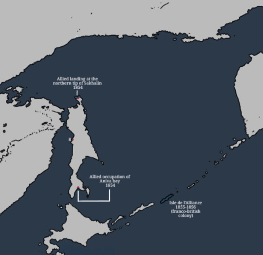
19. Alliance Island (Franco-British condominium colony) (2 Sep 1855 - 30 Mar 1856):
Source of map:
https://www.deviantart.com/lrtredgent/art/Map-of-all-french-possession-in-Asia-1106530233
20. Albion Island (Lost sand island) (19th century):

Source of map:
https://www.reddit.com/r/Maps/s/MiM3V15aqm
21. Canadian Concession of Vimy Ridge (Concession of the Dominion of Canada in the French Republic; Granted for the free use of Their Majesties' Governments in Canada for all time) (1922 - 1940, 1945 - Present):

Source of map:
https://www.veterans.gc.ca/en/remembrance/memorials/overseas/first-world-war/france/vimy/vimymap
22. Conway Reef (Annexed on 30 Jan 1965 to the Colony of Fiji, which was relinquished on 10 Oct 1970):

Source of map:
https://commons.wikimedia.org/wiki/File:Aneityum_1901_Nautical_Chart.jpg
23. Wrangel Island (Sole dominion of members of the Canadian Arctic Expedition (Jan - Sep 1914) and a private Canadian expedition to claim the island for Canada (1921-1923)) (Jan - Sep 1914, 1921 - 1923):

Source of map:
https://imgur.com/phDUNur
24. Republic of Angola (Applicant to the British Commonwealth) (2018 - Present):

Source of Map:
https://www.tumblr.com/w-r-pitt/779643631239839744/maps-of-twenty-five-obscure-british-colonial?source=share
25. Ottawa Civic Hospital Maternity Ward (Extraterritorial area for Princess Juliana of the Netherlands and any child that was born there, in the Dominion of Canada) (19 Jan 1943):

Source of map:
https://play.google.com/store/books/details?id=L_3NDwAAQBAJ
#history#colonialism#british empire#colonial era#colonial history#colonisation#colonization#british colonialism#european colonialism#european colonization#the british empire#british imperialism#british history#historical maps#map#maps#european history#uk#great britain#british#united kingdom#britain#British colonies
1 note
·
View note


Photo
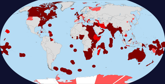
Every territory ever owned/claimed by the United Kingdom/England/British Empire
Keep reading
247 notes
·
View notes
Photo

India on the Eve of British Conquest, 1764.
Keep reading
334 notes
·
View notes

Photo

The amount of area the British Empire controlled at it’s peak (1920) represented as a single landmass in Asia.
292 notes
·
View notes
Photo

Countries that have gained independence from the United Kingdom / Great Britain.
701 notes
·
View notes
Photo
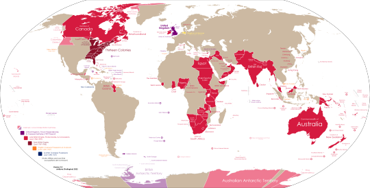
Comprehensive map of the British Empire - its colonies, territories, protectorates and more.
by u/awtizme
Keep reading
172 notes
·
View notes
Photo

British annexation of Indian Subcontinent by region.
66 notes
·
View notes
Photo
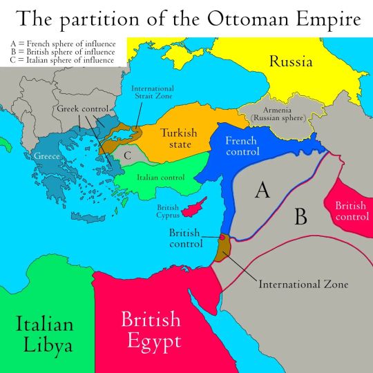
The partition of the Ottoman Empire after World War 1
🇹🇷 After World War I, the Ottoman Empire faced partitioning by the Allied Powers. The Sykes-Picot Agreement (1916) between Britain and France aimed to divide the Ottoman territories into spheres of influence. The agreement proposed British and French control over different regions, including parts of present-day Syria, Iraq, and Lebanon. Additionally, the Treaty of Sèvres (1920) outlined a more detailed plan for the partition of the Ottoman Empire. It proposed the creation of an independent Armenian state and the assignment of various regions to France, Italy, and Greece. However, this treaty was never fully implemented due to the Turkish War of Independence led by Mustafa Kemal Atatürk. The Treaty of Sèvres was replaced by the Treaty of Lausanne in 1923, which recognized the Republic of Turkey and established new borders, marking the end of the Ottoman Empire.
by danmaps_org
125 notes
·
View notes


Photo

British Empire in northern and Central Africa, 1914
by DanMaps/deviantart
57 notes
·
View notes
Photo

Cartogram comparing the British and Chinese Empires in 1916
76 notes
·
View notes
Text
Imperial Federation Map of the World Showing the Extent of the British Empire in 1886 - Boston Public Library

(And tutorial to make it into a little house 🖤)
2 notes
·
View notes