Don't wanna be here? Send us removal request.
Text
How can we tackle large-scale environmental challenges through landscape design? My short essay on digital design methods developed and taught at the Large-scale Virtualization and Modeling Laboratory (LVML) at ETH Zurich is now available online at @espazium.ch.
https://education.espazium.ch/fr/publication-universitaire/l-intelligence-numerique-pour-transiger-la-conception-de-l-espace-philipp-r-w-urech
instagram
1 note
·
View note
Text
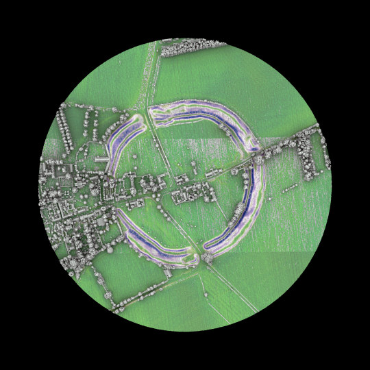
Avebury henge and stone circles are one of the greatest marvels of prehistoric Britain. Built and much altered during the Neolithic period, roughly between 2850 BC and 2200 BC, the henge survives as a huge circular bank and ditch, encircling an area that includes part of Avebury village. Within the henge is the largest stone circle in Britain - originally of about 100 stones - which in turn encloses two smaller stone circles.
Text Source: https://www.english-heritage.org.uk/ @englishheritage
Lidar Point Cloud 2019: https://environment.data.gov.uk/
1 note
·
View note
Text
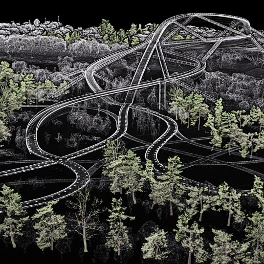
Work in progress. New vegetation is digitally placed on the designed topography and within the existing context to orchestrate visual relationships. The coloured trees are laser-scanned pine trees found in Zurich. Project: Qinhuai New River Entrance pedestrian bridge, Nanjing.
0 notes
Text
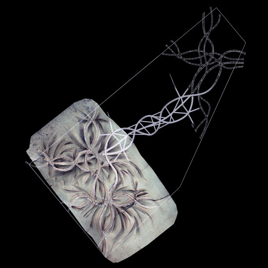
Work in progress. The terrain that was manually modeled on a clay model is virtualized and fitted to the context and the bridge. A watershed simulation shows how rain would flow through the site. Project: Qinhuai New River Entrance pedestrian bridge, Nanjing.
0 notes
Text
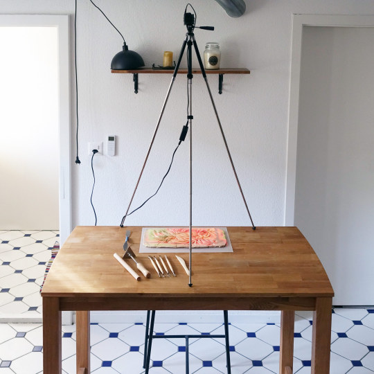
The schematic design phase of the Qinhuai New River Entrance Pedestrian Bridge project in Nanjing formalizes the competition proposal. Haptic and digital terrain modeling are combined to test topographic modulations for pattern matching effect with the bridge.
0 notes
Text
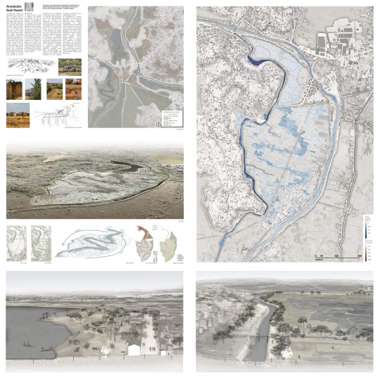
Laura Klinnert and Audrey Wurges designed a serpenting agricultural landscape for the polder "Antsimombohitra" in Antananarivo. The form derived from a precise morphological investigation of the site. Their project was presented at the Design Week in Antananarivo, and will be used in workshops with local actors in a co-designing process.
5 notes
·
View notes
Text
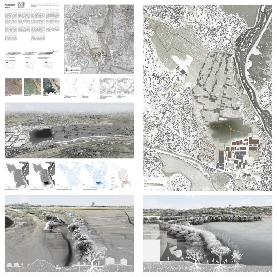
Proposal for polder “Ambaniala” in Antananarivo designed by the students Alan von Arx and Qianer Zhu in the Design Research Studio at the chair of Prof. Christophe Girot. Along other proposals, it was presented at the Design Week in Antananarivo as an innovative blue-green infrastructure solution.
1 note
·
View note
Text
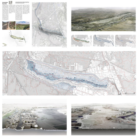
Point cloud modeling methods were taught at the Design Research Studio in fall 2022 at the chair of Prof. Christophe Girot to design peri-urban landscapes in Antananarivo. This proposal for the polder “Ankazotoho Anosimahavelona” was entirely developed on 3D point cloud models by students Josephine West and Aline Vonderwahl.
0 notes
Photo
This course at the ETH Zurich in Spring Semester 2023 builds on a long standing specialization in the spatial exploration of the landscape. It will embark students in architecture and engeneering on a terrain to be shaped by their own thoughts and actions, adopting different perceptual perspectives on familiar environments. The course gives the students the opportunity to learn how to use laser-scanning technology and acustic recording in order to analyze complex urban landscapes, interact with their qualities, and represent the characteristics of intertwined spaces.
Course Introduction : 23 February HIL H40.9 NSL Foyer Final Presentations : 11 May HIL H40.9 NSL Foyer
#ethzurich#eth#zurich#letten#teaching#liminalspace#pointcloudmodel#lidar#laserscanning#soundspectrummapping#digitalmodeling
2 notes
·
View notes
Photo
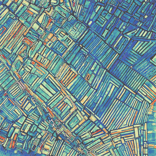
Vegetable fields in the high plains of Madagascar are recognizable by their longitudinal shape surrounded by irrigation channels. This morphology of terrain makes it possible to irrigate the clay soils without submerging the vegetables, which cannot withstand flooding. Course: Digital Design Methods 3, MScLA, ETH Zurich. Location: -18.887, 47.445, colored by height 1247.8 - 1248.8 m AMSL.
#ethzurich#eth#fcl#digitaldesignmethods#madagascar#antananarivo#teaching#pointcloudmodel#lidar#laserscanning#spectrummapping#scientificvisualization
3 notes
·
View notes
Photo
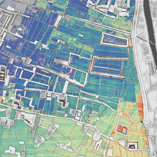
Fruit trees, mainly mango and mandarin, are found among the rice fields. These trees are hydrophobic and must be planted on high ground, appearing here as longitudinal islands separating the fields. Course: Digital Design Methods 3, MScLA, ETH Zurich. Location: -18.914, 47.442, colored by height 1247.5-1248 m AMSL.
#ethzurich#eth#fcl#digitaldesignmethods#madagascar#antananarivo#teaching#pointcloudmodel#lidar#laserscanning#spectrummapping#scientificvisualization
1 note
·
View note
Photo
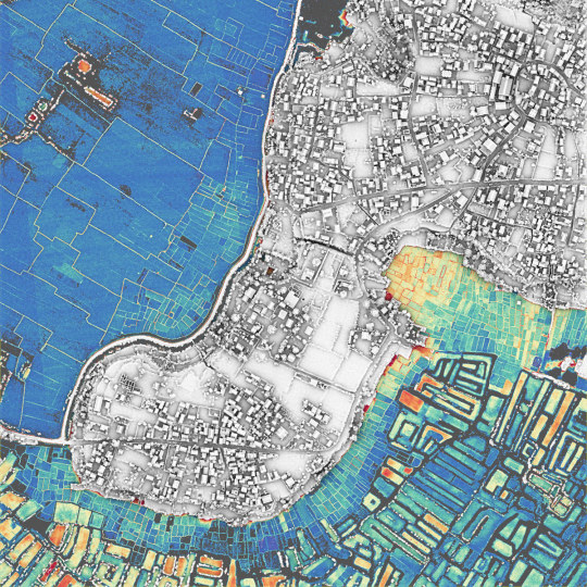
The hill settlements are typical of the Malagasy culture. The circle on the highest point is a heritage from ancient fortified villages. In the plains, it is easy to distinguish the rice fields, which stand low and are surrounded by a thin ring of dikes, and the vegetable fields, which are elevated and surrounded by irrigation canals. Course: Digital Design Methods 3, MScLA, ETH Zurich. Location: -18.897, 47.454, colored by height 1246.7-1247.7 m AMSL.
#ethzurich#eth#fcl#digitaldesignmethods#madagascar#antananarivo#teaching#pointcloudmodel#lidar#laserscanning#spectrummapping#scientificvisualization
0 notes
Photo
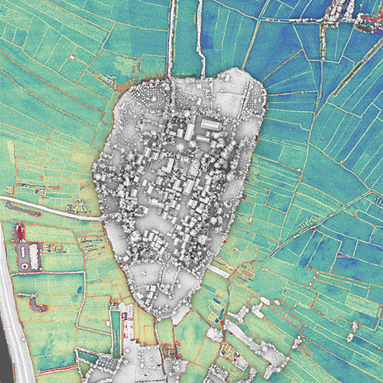
The village of Anosikely near Antananarivo is a landscape construct made of farming and flooding regimes. The village integrates the traditional layout of Malagasy villages and is surrounded by plot gardens of vegetables and fruit trees. Course: Digital Design Methods 3, MScLA, ETH Zurich. Location: -18.913, 47.448, colored by height 1247-1248 m AMSL
#ethzurich#eth#fcl#digitaldesignmethods#madagascar#antananarivo#teaching#pointcloudmodel#lidar#laserscanning#spectrummapping#scientificvisualization
0 notes
Photo
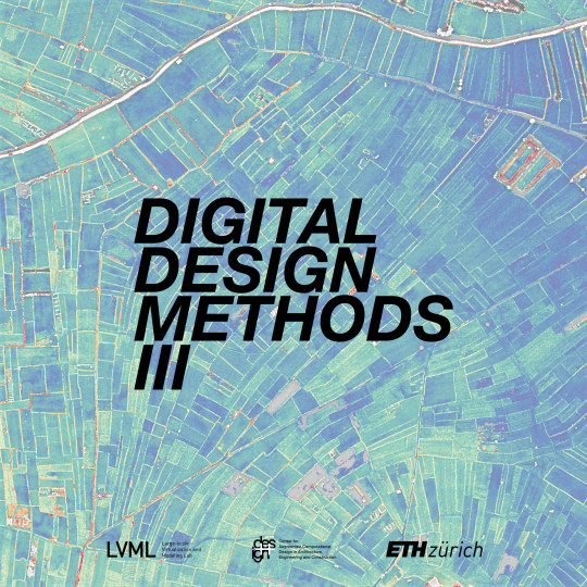
Digital Design Methods III is a module taught at the Master of Landscape Architecture @mscla_eth in Spring Semester 2023. Students will conduct a Remote Site Investigation (RSI) on the topography and floods of the urbanized high plains of Antananarivo, Madagascar. This course covers the most important digital methods in landscape architecture, from data collection to 2D and 3D modelling, analysis and simulation with various software solutions to visualizations and prototypes developed in the Large-scale Virtualization and Modeling Lab (LVML). The methods are also implemented in the MAS in Urban and Territorial Design.
1 note
·
View note
Photo
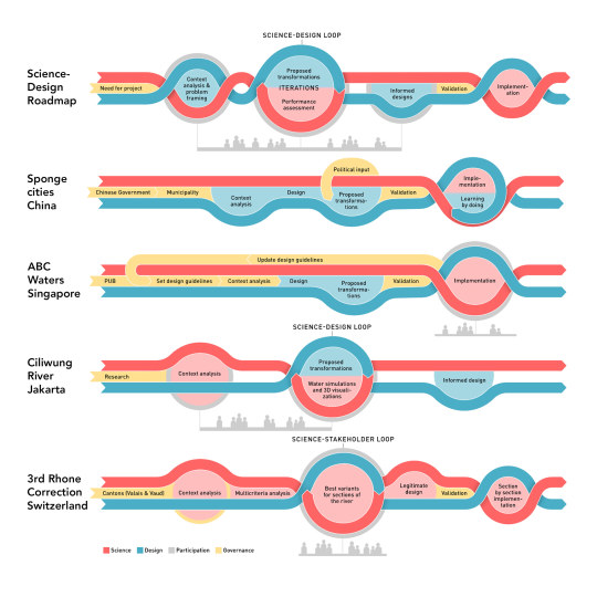
How is the design process of flood management and blue-green infrastructures structured to successfully co-construct and validate informed proposals? Based on prominent case studies around the world, including the Sponge Cities in China, the ABC Water in Singapore, the Ciliwung river in Jakarta, the 3rd correction of the Rhone River in Switzerland and the bioretention garden project in Detroit, we propose a roadmap to muster science and design in a balanced manner to effectively shape urbanized landscapes.
Open access: https://sesmo.org/article/view/18543
#ethzurich#landscapedesign#water#urbanlandscapetransformation#sciencedesignloop#interdisciplinarydialogue#bluegreeninfrastructures#floodmanagement#spongecities#abcwater#singapore#ciliwung#jakarta#rhone
1 note
·
View note
Photo
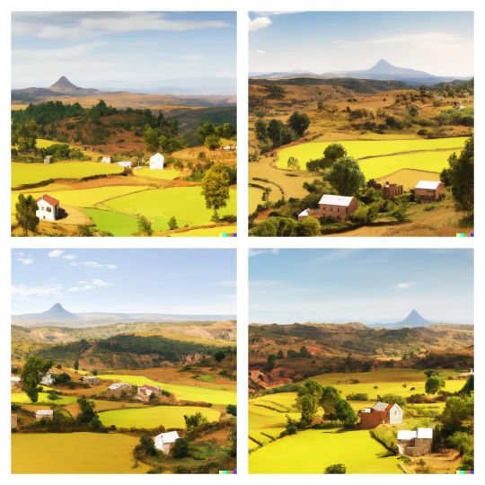
Data mining with AI computing is bearing fruit. Beyond the dazzling fashion by Nigerian filmmaker and artist Malik Afegbua @slickcityceo and the retro futuristic sets by Canadian director Johnny Darrell @johnny.darrell, this technology is opening a pandora's box of what creativity means. What we see is deeply intriguing: it is a mirror of our collective imagination, with all its beauty and biases. Here I wanted to see more trees in the landscape of Madagascar through OpenAI, using variations of the prompt: "madagascar rice fields landscape with many trees, adobe architecture, concept art". The AI knew that no one wants a tree in their rice field - a prejudice or a prediction? https://playgroundai.com/ https://midjourney.com/ https://labs.openai.com/
0 notes
Photo
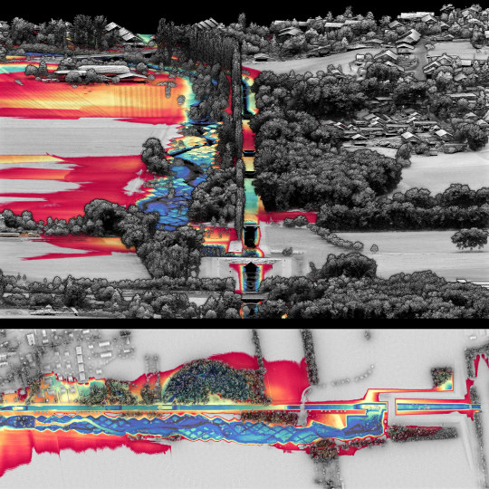
What is the imprint of topographic design? The design by George Descombes, started in the early 2000s and completed in 2015, demonstrates a site-specific approach that prompts a reflexion on the human-made artificiality and the natural flow of events. In this figure, a Relative Elevation Model (REM) based on a plane at river height was derived from the topographic lidar survey of 2019. The result highlights the microtopography around the river, in particular the rhombus tesselation eroded by the water flow. Source: schweizerkulturpreise.ch 3D Model: https://skfb.ly/oCEKH Data: Lidar 2019 by Swisstopo
4 notes
·
View notes