#topostudio
Explore tagged Tumblr posts
Text
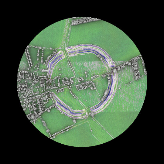
Avebury henge and stone circles are one of the greatest marvels of prehistoric Britain. Built and much altered during the Neolithic period, roughly between 2850 BC and 2200 BC, the henge survives as a huge circular bank and ditch, encircling an area that includes part of Avebury village. Within the henge is the largest stone circle in Britain - originally of about 100 stones - which in turn encloses two smaller stone circles.
Text Source: https://www.english-heritage.org.uk/ @englishheritage
Lidar Point Cloud 2019: https://environment.data.gov.uk/
1 note
·
View note
Text
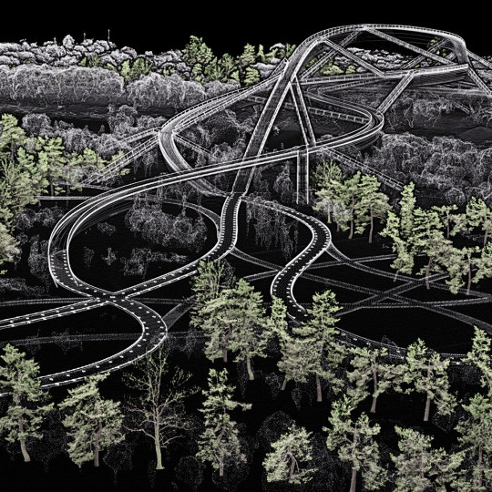
Work in progress. New vegetation is digitally placed on the designed topography and within the existing context to orchestrate visual relationships. The coloured trees are laser-scanned pine trees found in Zurich. Project: Qinhuai New River Entrance pedestrian bridge, Nanjing.
0 notes
Text
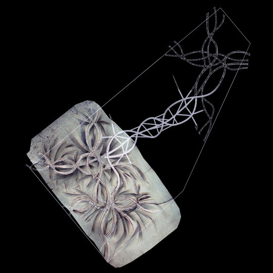
Work in progress. The terrain that was manually modeled on a clay model is virtualized and fitted to the context and the bridge. A watershed simulation shows how rain would flow through the site. Project: Qinhuai New River Entrance pedestrian bridge, Nanjing.
0 notes
Text
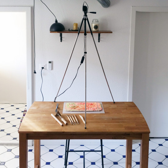
The schematic design phase of the Qinhuai New River Entrance Pedestrian Bridge project in Nanjing formalizes the competition proposal. Haptic and digital terrain modeling are combined to test topographic modulations for pattern matching effect with the bridge.
0 notes
Photo
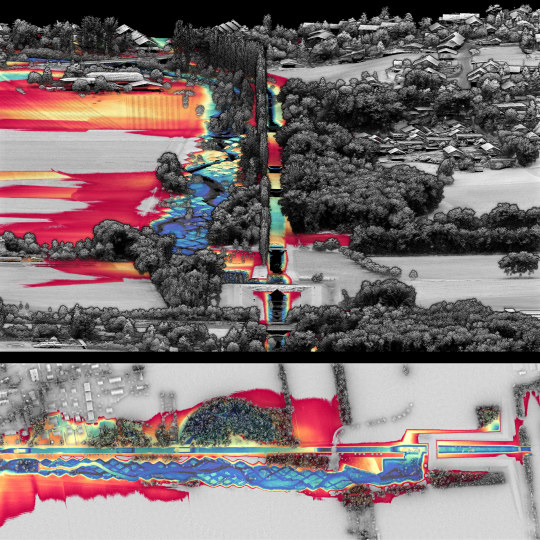
What is the imprint of topographic design? The design by George Descombes, started in the early 2000s and completed in 2015, demonstrates a site-specific approach that prompts a reflexion on the human-made artificiality and the natural flow of events. In this figure, a Relative Elevation Model (REM) based on a plane at river height was derived from the topographic lidar survey of 2019. The result highlights the microtopography around the river, in particular the rhombus tesselation eroded by the water flow. Source: schweizerkulturpreise.ch 3D Model: https://skfb.ly/oCEKH Data: Lidar 2019 by Swisstopo
4 notes
·
View notes
Photo
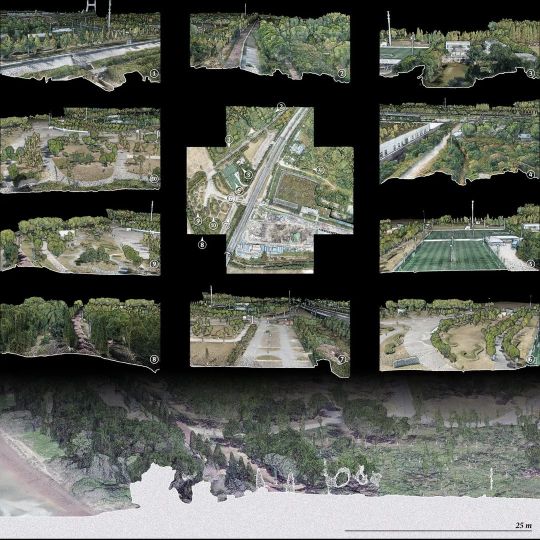
A precise digital model was crucial to analyse the placement of the new pedestrian bridge. The digital model indicates topographic elevations ranging from 4.5 to 13.5 m above sea level in the form of polders that are drained by pumping stations. The height of current vegetation ranges from 3 - 40 meters. The digital model allowed us to calculate precisely earth changes as a base for the design proposal.
Project: Qinhuai New Pedestrian Bridge in Nanjing, 1st prize Architecture: Christian Kerez Structural Engineer: Joseph Schwartz Collaborators: Yan Junjie, Liu Yiqiu Landscape Design: Philipp Urech (Topostudio), Liu Yiqiu
4 notes
·
View notes
Photo
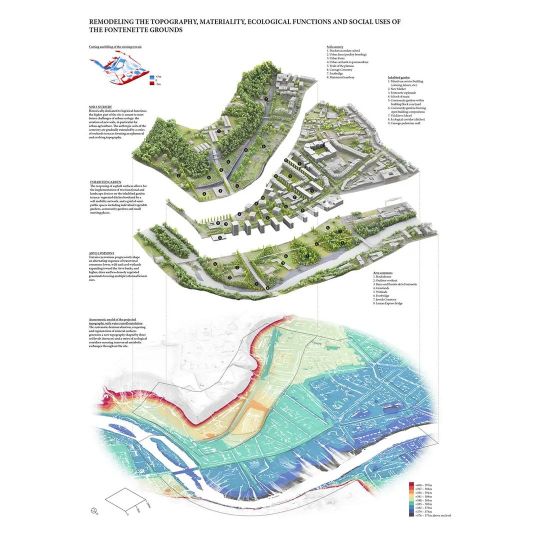
Our entry for the Europan E16 @europan_europe competition "Carouge – Fontenette: Reinventing A Territory With Nature". The second panel presents design strategies around THREE SOILS based on a Circular Economy of Materials. The proposal draws on lidar measurements by @Swisstopo to precisely deconstruct and manipulate the existing topography, then simulate runoff.
Project in collaboration with Dr. Antoine Vialle (architect) and Dr. Yannick Poyat (engineer). Our proposal was rewarded with the second prize.
https://www.europan-europe.eu https://www.europan.ch/
#urbandesign#urbanlandscape#lidar#digitallandscape#sitespecific#urbanheritage#europan#livingcities#geneva#carouge#fontanette#e16#competition#topostudio
2 notes
·
View notes
Photo
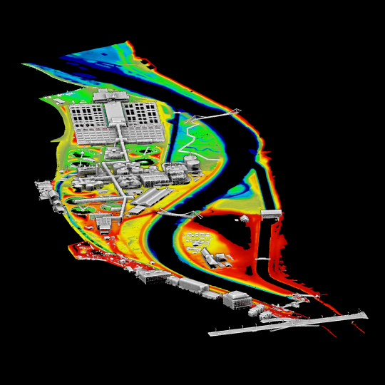
Werdhölzli is the wastewater treatment plant of the city of Zurich and is the largest wastewater treatment plant in Switzerland. The water passes through mechanical purification (1), biological purification (2), chemical purification (3), ozonation (4), filtration (5) and is finally discharged into the Limmat River through outlet structures. Underground tanks (6) increase the retension capacity. The terrain points in the digital model are colored by elevation (394-399 m AMSL) and cropped above 399 m.
Explore the 3D model: https://skfb.ly/o6KnH
#survey#topography#pointcloudmodel#landscape#lidar#cloudcompare#morphology#zurich#werdhölzli#werdinsel#topostudio
2 notes
·
View notes
Photo
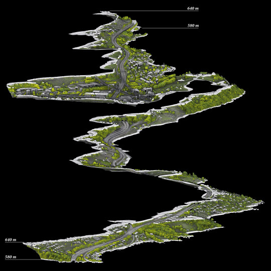
The Swiss Highway A9 evolving along the lake of Geneva is one of the most scenic roads in Switzerland. In this model, the geometry has been segmented between 580 and 640 m of altitude, with cuts emphasized by 5 m wide strips. It shows the constructive prowess of engineers who designed this segment in the 1970s, which despite its extreme artificiality has a soft and sinuous shape to allow mobility through difficult topography.
2 notes
·
View notes
Photo
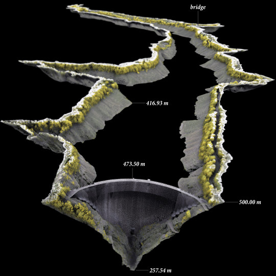
The point cloud model represents an arch dam built in the Verzasca Valley between 1961 and 1965. The points, segmented above 500m AMSL, were measured with two-digit precision using airborne LiDAR in 2020 by Swisstopo. Some modeling disassembly and reassembly of the point cloud model was made to selectively filter and color the points. The model reveals fascinating landscape details such as the former road and bridge that sometime reappear from the lake's waters.
View 3D model: https://skfb.ly/on9yx
#survey#topography#pointcloudmodel#landscape#lidar#verzasca#ticino#switzerland#swissheritage#actofmapping#showitbetter#urbandesignlab#illustrarch#topostudio
2 notes
·
View notes
Photo
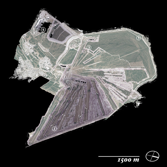
The lignite in the open-pit mine Inden, North Rhine-Westphalia, is extracted with bucket-wheel excavators (1). The conveyor belts (2) transport residue material to stockpiles (3) and the lignite uphill to the Weisweiler coal power plant (4). The diverted section of the Inde River runs around the mine as a reclaimed landscape (5). The open lidar data was subsampled, segmented, colored by height, type and slope. The point cloud model, visualized here in axonometry, is available for 3D view/download in the link.
Data: https://www.geoportal.nrw/ Model: https://sketchfab.com/prwurech/models
#survey#topography#pointcloudmodel#landscape#lidar#cloudcompare#geology#inden#tagebau#actofmapping#showitbetter#axo_madness#archisketcher#axonometric#thearchilogist#urbandesignlab#illustrarch#topostudio
1 note
·
View note
Photo
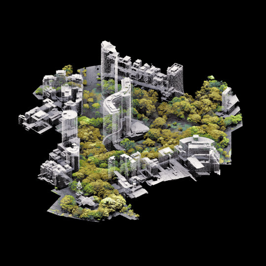
Urban heat, pollution, noise, overcrowding are urgent problems of high density cities. Density, inevitable in metropolitan areas, is merely the issue. Instead the surrender of public space to individual long-distance transportation is inefficient and detrimental. The absurd, yet tempting imagination of the Niemeyer's Edifício Copan standing in an urban park is an utopia. But with growing environmental pressure, such urban acclimatization landscape might be the inevitable and only solution for resilient future cities.
3D model: https://skfb.ly/6SI9L Data source: airborne open LiDAR data of the São Paulo City, collected in 2017, available at http://geosampa.prefeitura.sp.gov.br/
#pointcloud#als#survey#urbanlandscape#idiosyncraticmodeling#copan#niemeyer#saopaulo#sketchfab#topostudio
1 note
·
View note
Photo
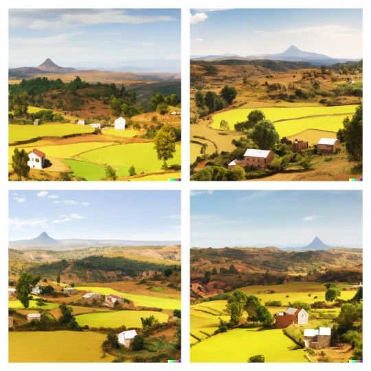
Data mining with AI computing is bearing fruit. Beyond the dazzling fashion by Nigerian filmmaker and artist Malik Afegbua @slickcityceo and the retro futuristic sets by Canadian director Johnny Darrell @johnny.darrell, this technology is opening a pandora's box of what creativity means. What we see is deeply intriguing: it is a mirror of our collective imagination, with all its beauty and biases. Here I wanted to see more trees in the landscape of Madagascar through OpenAI, using variations of the prompt: "madagascar rice fields landscape with many trees, adobe architecture, concept art". The AI knew that no one wants a tree in their rice field - a prejudice or a prediction? https://playgroundai.com/ https://midjourney.com/ https://labs.openai.com/
0 notes
Text
Some human history is manifested in architectural artifacts ― a reminder on how ground, place and territory have always been an obsession for our kind. What is the difference in thought between placing the foundation stones of Tikal and those of a contemporary house?
Open data by CyArk: https://doi.org/10.26301/708h-ss96 Survey report: artsandculture.google.com Virtual tour: cyark.org
0 notes
Photo
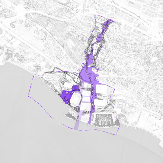
Happy to have contributed in an amazing team to the launch of the competition of Lausanne Jardins 2024. @lausanne.jardins is a cultural event that combines landscape architecture with reflection on the city. Maps based on lidar data, edited by Notter + Vigne.
Website: https://lausannejardins.ch/
#lausannejardins2024#lausannejardins#lj24#entreleauetvous#concours#paysagisme#architecture#mylausanne#lausanne#topostudio
0 notes
Photo

Plan view of the competition design (1st prize), developed within the topographic polder setting of the Qinhuai River's mouth into the Yangze. Project: Qinhuai New Pedestrian Bridge in Nanjing // Architecture: Christian Kerez // Landscape Design: Philipp Urech (Topostudio), Liu Yiqiu // Structural Engineer: Joseph Schwartz // Collaborators: Yan Junjie, Liu Yiqiu
See 3D model: https://skfb.ly/oxELo
0 notes