#the colorado and ohio are from google
Explore tagged Tumblr posts
Text


Red license plates
1 note
·
View note
Text
IMPORTANT INFORMATION TO HAVE IF YOU PLAN ON VOTING IN THE US ELECTION (November 5th, 2024):
IF you don’t have a way to get to your polling place both Uber and Lyft are offering 50% off of trips to your polling place! For Lyft you can use their code VOTE24 and on uber there will be a space on the app that says “Go Vote!” that will show you all the available promotions you can use to get to your polling place.
if you don’t know what your polling place is you can go to vote.org/polling-place-locator and check the voter registration logs in your state OR you can google “polling place locator” and there should be a widget that will show you where to go if you enter in your address (NOTE: ENTER YOUR PERMANENT ADDRESS, I.E the address on your drivers license or the address that you put down when you registered to vote)
If English is not your first language or primary language, you can ask for a translator to assist you or you can ask one of the workers at your polling place if they have non-English language ballots (this is only available in some states and counties but it is a good idea to ask regardless)
IF YOU LIVE IN ANY OF THE FOLLOWING STATES, YOU MUST HAVE A PHYSICAL GOVERNMENT ISSUED I.D TO VOTE:
Alabama, Arkansas, Arizona, Florida, Georgia, Idaho, Indiana, Kansas, Louisiana, Michigan, Mississippi, Missouri, Montana, Nebraska, North Carolina, Ohio, Rhode Island, South Carolina, South Dakota, Tennessee, Texas, Wisconsin, Wyoming
USE THIS SITE TO FIND OUT IF YOUR STATE HAS SAME DAY VOTER REGISTRATION -> https://www.rockthevote.org/how-to-vote/same-day-voter-registration/
USE THIS SITE TO FIND OUT IF YOUR STATE REQUIRES YOUR EMPLOYER TO GIVE YOU TIME OFF TO VOTES -> https://ballotpedia.org/Time_off_work_for_voting
UNDER THE READ MORE I HAVE LINKS TO VOTER GUIDES FOR EVERY STATE + WASHINGTON D.C. THAT HAVE INFORMATION ON THE POSITIONS OF EACH CANDIDATE AND SUMMARIES OF BALLOT MEASURES YOU WILL BE VOTING FOR/AGAINST - YOU ARE ALLOWED TO BRING YOUR PHONE INTO THE BOOTH SO USE THESE AS A GUIDE!
Alabama Voters Guide from Alabama Reflector -> https://alabamareflector.com/voter-guide/2024/
Alaska Beacon’s 2024 voter guide -> https://alaskabeacon.com/voter-guide/2024/
Arizona 2024 voter guide -> https://www.azvoterguide.com/
Arkansas Voter Guide from the Arkansas Advocate -> https://arkansasadvocate.com/voter-guide/2024/
California Voters Guide from the League of Women Voters of California (Available in Multiple Languages) -> https://cavotes.org/easy-voter-guide/
Colorado Voters Guide from Colorado Public Radio -> https://www.cpr.org/2024/10/14/vg-2024-colorado-voter-guide-to-the-2024-election/
Connecticut Voter Guide from Connecticut Insider -> https://www.ctinsider.com/projects/2024/elections/ct-election-2024-voter-guide/
Delaware Voters Guide from Delaware Journalism Coalition -> https://www.dejournalism.org/2024-voter-guide-for-delaware/
Florida Voter Guide from League of Women Voters Florida -> https://lwvfl.org/vote2024/
Georgia Voters Guide -> https://thegeorgiavoterguide.com/
Hawaii Voting Information from Vote411 -> https://www.vote411.org/hawaii
Idaho Voters Guide from Idaho Capital Sun -> https://idahocapitalsun.com/voter-guide/2024/
Illinois Voters Guide -> https://illinoisvoterguide.org/
Indiana Voters Guide from Vote411 -> https://www.vote411.org/indiana
Iowa Voters Guide from Iowa Public Radio -> https://www.iowapublicradio.org/political-news/2024-09-18/iowa-ballot-2024
Kansas Voters Guide from BallotReady -> https://www.ballotready.org/us/kansas
Kentucky Voters Guide from Kentucky Election Org -> https://www.kentuckyelection.org/
Louisiana Voters Guide from The Louisiana Illuminator -> https://lailluminator.com/voter-guide/2024-louisiana-voter-guide/
Maine Voters Guide from Maine Morningstar -> https://mainemorningstar.com/voter-guide/2024/
Maryland Voters Guide from Maryland Matters -> https://marylandmatters.org/voter-guide/2024/
Massachusetts Voters Guide from CBS News -> https://www.cbsnews.com/boston/news/whats-on-2024-election-ballot-massachusetts/
Michigan Voters Guide from the Michigan Voters Information Center -> https://mvic.sos.state.mi.us/publicballot/index
Minnesota Voters Guide from the Minnesota Star Tribune -> https://www.startribune.com/minnesota-2024-voters-guide-whos-running-where-they-stand-on-the-issues/601147912
Mississippi Voters Guide from the Mississippi Clarion Ledger -> https://www.clarionledger.com/story/news/politics/2024/10/31/mississippi-voter-guide/75894837007/
Missouri Voters Guide from Missouri Channel 8 News -> https://www.komu.com/news/elections/november-2024-voters-guide/article_9ef3fa62-8cbf-11ef-903d-2bc40682f247.html
Montana Voters Guide from Montana Free Press -> https://apps.montanafreepress.org/election-guide-2024/
Nebraska Voters Guide from Flatwater Free Press -> https://voterguide.flatwaterfreepress.org/
Nevada Voters Guide from Vote411 -> https://www.vote411.org/nevada
New Hampshire Voters Guide from Seacoast Online -> https://www.seacoastonline.com/story/news/politics/elections/2024/11/03/seacoast-nh-election-2024-voter-guide-candidates-where-to-vote/75988328007/
New Jersey Voters Guide from Ballot Ready -> https://www.ballotready.org/us/new-jersey
New Mexico Voters Guide from Source New Mexico -> https://sourcenm.com/voter-guide/2024/
New York Voters Guide from Times Union -> https://www.timesunion.com/projects/2024/new-york-voter-guide-general-election/
North Carolina Voters Guide from NCVoterGuide -> https://ncvoterguide.org/
North Dakota Voters Guide from The North Dakota Monitor -> https://northdakotamonitor.com/voter-guide/2024/
Ohio Voters Guide from The Ohio Capital Journal -> https://ohiocapitaljournal.com/voter-guide/2024/
Oklahoma Voters Guide from The Oklahoma Voice -> https://oklahomavoice.com/voter-guide/2024-oklahoma-elections/
Oregon Voters Guide from The Oregon Capital Chronicle -> https://oregoncapitalchronicle.com/voter-guide/2024-general-election/
Pennsylvania Voters Guide from BallotReady -> https://www.ballotready.org/us/pennsylvania
Rhode Island Voters Guide for Rhode Island Current -> https://rhodeislandcurrent.com/voter-guide/2024/
South Carolina Voters Guide from Vote411 -> https://www.vote411.org/south-carolina
South Dakota Voters Guide from South Dakota Searchlight -> https://southdakotasearchlight.com/voter-guide/2024/
Tennessee Voters Guide from Tennessee Lookout -> https://tennesseelookout.com/voter-guide/2024-election/
Texas Voters Guide from Vote411 -> https://www.vote411.org/texas
Utah Voters Guidefrom The Utah News Dispatch -> https://utahnewsdispatch.com/voter-guide/2024/
Vermont Voters Guide from BallotReady -> https://utahnewsdispatch.com/voter-guide/2024/
Virginia Voters Guide from The Virginia Mercury -> https://virginiamercury.com/voter-guide/2024-virginia-voter-guide/
Washington Voters Guide from Cascade PBS -> https://www.cascadepbs.org/voter-guide/washington-statewide-voter-guide-2024
Washington D.C. Voters Guide from WTOP News -> https://wtop.com/dc-election/2024/10/dc-2024-general-election-voter-guide-everything-you-need-to-know/
West Virginia Voters Guide from Mountain State Spotlight -> https://mountainstatespotlight.org/west-virginia-2024-voter-guide/
Wisconsin Voters Guide from My Vote Wisconsin -> https://myvote.wi.gov/en-us/Whats-On-My-Ballot
Wyoming Voters Guide from WY VOTE -> https://wyvote.vote/
#wren.txt#us elections#uspol#us politics#2024 election#2024 presidential election#i hope y’all appreciate this and that it’s helpful!! it took me like two hours to put together cause i tried to#find the best options for each voter guide#<- making this my pinned for today as a helpful guide
210 notes
·
View notes
Text
Hi! I know all my US moots are most likely asleep, but I need your help! So my current fic has the boys driving from LA to NY. I'm on google maps, but it's giving me two different routes. So would the logical choice be California, Nevada, Utah, Colorado, Nebraska, Iowa, Illinois, Indiana, Ohio, Pennsylvania, NY or California, Arizona, New Mexico, Texas, Oklahoma, Arkansas, Tennessee, Virginia, Pennsylvania, NY
(I have never been to the US)
Thank you ILY
22 notes
·
View notes
Text
Good Stuff in 2023
Since every year seems to be shit, I thought I would go through some major news stories and pick out the ones that seemed pretty good, actually. There's a bit of a USA bias in the source I used... but here's some year-end positivity, anyway!
January
An ebola outbreak was successfully controlled in Uganda
Sierra Leone introduced a law that reserves more jobs for women
The UN declared the current approach to repairing the ozone layer is successful and could return it to 1980 levels
New York's gun restrictions were upheld by the Supreme Court
February
Google lost $100bn in shares because its chatbot was crap (lol)
Tesla had to recall over 350,000 cars because its self-driving system was crap (lmao)
March
The International Criminal Court put out a warrant for the arrest of Vladimir Putin
12 Democrat-led states in the USA sued to attempt to protect access to mifepristone (an abortion inducing drug)
Donald Trump was charged with criminal offences in New York
The Royal Society tested robotic prosthetics with the public and found that over 95% of people could use them well within the first minute
April
Finland was approved to join NATO
Christina Koch was announced as the first woman and Victor Glover as the first black astronaut on a NASA lunar mission
The tiger population of India was confirmed to have risen by around 200
A SpaceX rocket blew up (haha)
Japan approved an abortion pill for use for the first time
Pope Francis announced that women would be allowed to vote in meetings of bishops
The US Supreme Court rejected a West Virginia transgender athlete ban
Washington state eliminated the death penalty and sterilisation as criminal punishment
The US Supreme Court protected access to mifepristone (see March)
The UK fined TikTok for mishandling children's data
NASA was able to extract oxygen from lunar soil
Germany confirmed the shut down of nuclear power stations in the interest of safety
May
Colorado state signed several gun control bills into law
Donald Trump was found liable in a civil case where he was accused of rape and defamation
North Carolina's governor vetoed an abortion ban
The UK's first "three-parent baby" was born via IVF
June
Former Brazil president (Collor) was sentenced to prison for corruption
Federal courts blocked laws preventing healthcare for young trans people in Kentucky and Tennessee
July
Donald Trump's request for a new trial (see May) was rejected
Sweden's bid to join NATO was backed by Turkey
August
FDA approved use of the first drug (Zuranolone) to treat postpartum depression
Direct detection and nanopore sequencing (DDNS) used to halve the time for polio detection
India's space agency achieved their first unmanned moon landing
September
Mexico's Supreme Court decriminalised abortion rights
The African Union permanently joined the G20
The EU raised their renewable energy targets
Donald Trump was found guilty of fraud in New York
Apple announced a switch to USB-C charging ports in its new iPhone
October
California banned driverless taxis
November
A court in South Africa ruled in favour of introducing shared parental leave
The UK Supreme Court blocked plans to send asylum seekers to Rwanda
An assault weapons ban in Illinois was upheld by an appeals court
The first images were received from ESA's Euclid space telescope
The EU started talks to bring Ukraine into the union
December
41 workers were rescued from a tunnel under the Himalayas in India
Pope Francis allowed priests to bless same-sex couples (but not for marriage... but still a win maybe?)
Supreme Court dismissed Ohio's attempt to enforce an abortion ban
Colorado's Supreme Court declared Donald Trump ineligible to run for office (only applies to Colorado)
IBM unveiled a quantum computing chip and machine
Google, Meta and other tech companies agreed to work towards open digital ecosystems (prompted by EU regulations on digital markets)
2 notes
·
View notes
Text
The apartment search website Abodo created a map outlining the most racist areas in the nation. The site used software that tracked over 12 million tweets posted in 2014 and 2016, filtering out tweets with racial slurs.
Based on these findings, West Virginia was revealed to be the most racist state. Maryland and Louisiana were also the most racist states based on racial slurs used on Twitter.
---------------------------------
Most Racist States [Updated May 2023]
Racism is defined as prejudice or discrimination against people of different races. A racist person believes that his or her race is superior, while other races are inferior. While Americans might think that racism is most prevalent in the United States, it is considered more welcoming and accepting than many other countries. Some of the most racist countries are Bahrain, Lebanon, India, South Africa.
Racism in a given area isn’t something that can be measured like population or area. Polls and surveys can be used, but these aren’t always accurate. Other data, such as instances of hate crimes and hate speech, can also be used to determine where racism is most prevalent.
Because of this, it’s difficult to measure what states in the U.S. are the most racist. However, some organizations and publications have attempted to measure racism throughout the United States. The following contains some of these findings.
Arizona - 75.16
Hawaii - 74.48
Texas - 74.08
Montana - 73.95
Maryland - 72.84
New Mexico - 72.80
Wyoming - 72.77
Alaska - 72.46
Washington - 72.43
Georgia - 72.35
Kentucky - 71.44
Delaware - 71.28
Idaho - 69.92
West Virginia - 69.45
Virginia - 69.19
Florida - 69.08
North Carolina - 68.18
Colorado - 68.06
Tennessee - 67.77
Nevada - 67.71
Vermont - 65.86
Rhode Island - 65.80
Oklahoma - 65.54
California - 65.30
Indiana - 64.37
Missouri - 63.88
New Jersey - 62.84
Alabama - 62.72
Kansas - 62.11
Connecticut - 61.80
Utah - 61.68
Arkansas - 61.62
Massachusetts - 61.12
Mississippi - 60.55
Oregon - 60.22
New Hampshire - 59.95
South Carolina - 59.88
New York - 59.74
Maine - 59.73
Ohio - 57.66
North Dakota - 55.99
Michigan - 55.32
Nebraska - 54.91
Pennsylvania - 54.69
Louisiana - 54.18
Illinois - 53.13
South Dakota - 52
Minnesota - 49.84
Iowa - 44.68
Wisconsin - 33.01
DC - 28.36
Another study was conducted by data scientist Seth Stephens-Davidowitz using Google search data. Based on this data, the study found that the most racist regions in the United States are the rural Northeast and South, which were slave states before the American Civil War.
Searches containing racial slurs were most prevalent in the Appalachian region from Georgia to New York and Vermont.
High concentrations of racist searches were discovered in areas along the Gulf Coast, the Upper Peninsula region in Michigan, and Ohio.
However, it is important to note that these findings aren’t an official ranking of racist states. These studies give some idea of areas in the nation where racism may occur. Some of the states that have made the most racial progress are New Mexico, Hawaii, and Wyoming.
Here are the 10 states with the highest total racism scores:
District of Columbia - 28.36
Wisconsin - 33.01
Iowa - 44.68
Minnesota - 49.84
South Dakota - 52
Illinois - 53.13
Louisiana - 54.18
Pennsylvania - 54.69
Nebraska - 54.91
Michigan - 55.32
#most racist states ranking#50 states#us states racism index#racism by state#us racism#racism in the us#racism in us states list
3 notes
·
View notes
Text
America's Infatuation With Mass Shootings
infatuation is best described as an intense passion, or admiration, for something. In this case, the 2nd Amendment's controversial right to bear arms.
According to an article I recently encountered, the Associated Press and USA Today, in conjunction with Northeastern University, reported there have been 2,842 citizens of the United States that have been murdered in mass shootings since 2006.
This AP/USA Today statistic demonstrates these horrific events are currently happening on an average pace of every 6.53 days, that makes them take place about once a week. I wonder have they not penetrated the American psyche yet?
A particular reason 2023 stands out compared to other years since data has been compiled on mass shootings is approximately one-third of the way through the calendar year there have been 17 of these nightmares that have occurred.
In half of the years since statistics have been maintained on the subject of mass shootings (2006 to 2023), according to the aforementioned AP/USA Today article cited, there have been 30 or fewer mass killings that took place each year.
In 2023 mass shootings have occurred over a period of about 111 days, give or take a few, and ended 88 lives that can never be returned. These numbers place the United States on a record pace for mass killings. Don't get me wrong, because I believe each lost life snuffed out in mass shootings is indeed a tragedy.
Let's examine some of the 2023 mass shootings that have occurred.
-January 23, at Half Moon Bay, 7 farmworkers were killed in Northern California over a workplace grudge
-April 15, dancers at the Mahogany Masterpiece Dance Studio outside Los Angeles, California were massacred as they celebrated the Lunar New Year
-March 27, six children at the Covenant School, in the Green Hills neighborhood of Nashville, Tennessee. This Commentator resides not too far from this locale. Therefore, this incident hit fairly close to home for moi.
-April 1, at a Sweet 16 celebration in Dadeville, Alabama in which four partiers were killed and 52 others injured
-April 18, in Bowdoin, Maine, committed by a felon just released from prison, who killed four people, including his parents, then opened fire on motorists on Interstate 295 in Yarmouth
-April 10, in Louisville, Kentucky where 5 were killed, and 8 wounded, at the Old National Bank
Is there any wonder this world appears to get crazier with each rising sun?
Can you guess how many states have experienced mass shootings over the years? Google if you desire, but here is the list. It is almost a take your pick situation.
Texas, North Carolina, Georgia, Connecticut, Maine, Maryland, Hawaii, Mississippi, Alabama, Kentucky, California, Michigan, Minnesota, New York, Ohio, Indiana, New Jersey, Florida, South Carolina, Louisiana, Illinois, Pennsylvania, Virginia, Kansas, Colorado, Oklahoma, Wisconsin, Arkansas, and Tennessee. That is 30 out of 50. Toss in Washington, D.C. for good measure, and it begins to sound similar to a broken record, doesn't it?
Perhaps no one should be surprised by these mass killings, that appear to have become a way of life for the fabric of the United States, and may have made Americans immune to them. Or should people be very much concerned about them? If that is correct, isn't it significantly high time something was done to eliminate their occurrences?
2 notes
·
View notes
Text

Biden Administration Proposes Trans Kids Cry Into the Colorado River to Help Raise Water Levels as The River Continues to Shrink
IDC News: 11 April 2023 (Evening Edition)

The Colorado River was voted "Most Likely Reason Climate Change Will Kill Us" for the 12th year in a row, Last Saturday at the MTV Kid's Choice Awards.
OHIO — After months of furious debate between the Western states that depend on the shrinking Colorado River for fresh water, the Biden administration on Tuesday announced a sweeping new plan that would set aside decades of legal precedent to save the River by turning to an unlikely ally: transgender youth in America
Such a brazen effort to reach across the gender neutral bathroom style has never been seen in US history. If successful, it would mark one of the first times the country has acknowledged the existence of young transgender Americans. A sign of just how stark things have become.
The Plan is Simple.

Decades of overuse on top of a 23-year drought means there is no painless way out.
The Biden administration spoke to reporters on Tuesday together with representatives from the Environmental Protection Agency (EPA). They outlined a 6-step agenda which Vice-President, Kamala Harris, said "all but guarantees that by this time next year, you won't be able to tell the difference Cardi B and the Colorado River".
The Agenda lays out a list of steps that will be taken, effective immediately, to save the rapidly dwindling amounts of water in the River.
The Agenda
Encourage American parents to be harsher on their transgender children
Set-up a 'safehouse' in Utah next to the Colorado River
Rescue transgender teens from abusive homes by driving them to the Utah safehouse
Bring all the transgender teens outside, line them all up one by one single file above the Colorado River
Show every teenager a picture of themselves.
When the dysphoria causes them to cry, the teens will already be in an ideal position to refill the Colorado River as their tears will drain straight into the water basin

Me and My tampon on the last day of my period
"Wow um, these teenagers are really depressed"
Climate researchers were skeptical at first about the plan's long-term viability. Vivian Lee, a postgraduate student studying moisture at the California Institute of Technology (CALTECH) noted that it was unlikely the plan would produce any meaningful amount of water, far from enough to replenish the drying River.
However, Lee's jaw dropped when she saw the data. The results were clear. And shocking.

(Above) The Colorado River is fucked.
"Holy shit there's no way. The Average transgender teen in America cries approximately 60 gallons of water in a week?" Lee read from a recent study.
That is, of course, only an average. In some states like Florida, numbers can go as high as 90. At the end of the day, what's clear is clear.

What's clear is clear.
On average, transgender teenagers in America lose enough water every week from crying to fill the equivalent of an Olympic-sized swimming pool. Done right, the Biden team's plan could generate up to 100,000 additional litres into the Colorado River each year.
"We need to learn to harvest their energy. The young ones are ripe and full. It is nearly time for us to sow the seeds of our harvest and consume the bounty we have planted," said possible serial killer, Ted Cruz.
Some have expressed concern that the plan is inhumane and exploits the misery of transgender youth to support America's continual deathward spiral into climate self-destruction. However, representatives of the plan in D.C. pushed back, noting that all volunteers would be compensated with a Blåhaj and work experience which they could put on a resume.
At press time, US President Joe Biden was seen trying to Google whether the transgender day of visibility had any relation to wearing camo.
#comedy#meme#memes#dank memes#funny memes#lgbtq#lgbtq memes#lgbtqia#lgbt#lgbt memes#queer#queer memes#sapphic#sapphic memes#wlw memes#wlw#trans#transgender#trans memes#satire#news satire#climate#climate change#climate crisis
6 notes
·
View notes
Link
#Online #Reputation Management# #Crisis Remove Complaints# Consultants# Services# Local# #Search #Engine Optimization# SEO# GMB# Tools# Software# Online# Companies# Reviews# Tips# Social Media Management# Remove Complaints# BBB# RipOffReport.com# Complaints.com# ComplaintsBoard.com# Blogs # Reviews# Webites# Online# Advertising# Marketing# Ads# Computer# Web Site Development# Hosting# TV# Television# Commercials# Internet# PR# Public Relations# Legal# Lawyer# Law# Attorney# Attorneys# Finance# Loan# Classifieds# Directories# Local Search# Business Leads# Sales Leads# Personal Data Removals# Internet Legal# Training Seminars
2 notes
·
View notes
Text
i was tagged by fritz @vintagecocacolainthesun to do this little thing and i don’t do them a lot but i’m in ohio so i’m going to do this one.
nickname: mostly just. my name. no one’s really given me a nickname
height: 5’4” but very nearly 5’5”
last thing i googled: sofia the first cast and before that largest agricultural export of spain (its olive oil btw)
song stuck in my head: lately it’s been wait for it from the hamilton soundtrack bc i just saw hamilton last week and now the little broadway worms have writhed their way into my brain again
amount of sleep i get: i don’t really. i got a few hours tonight. when i’m at home i sleep like 6-8 hours a night but here it’s like. 1-3
dream job: high school drama teacher. i’ll never probably get to do that but i’d love to.
wearing: a black dress and a white ruffled button up under it bc my grandparents are making me go to a Lutheran Church (pls someone get me out of Ohio) also a not-actually-leather jacket from Daniel Howell’s Liveshow
movie/book that summarises me: Cloud Atlas. the summary is that everyone everywhere will live and create and die and have an impact on life and isn’t that tragic and beautiful? it’s a great movie and book.
current favorite song: Car Lights — James Marriott
aesthetic: introspective little guy? i have no idea. dude who eats soup
favorite author: Claire Keegan, Diane Duane, David Mitchell, Terry Pratchett, many others
random fact: The largest agricultural export of Colorado is beef and veal. in Ohio it is corn. in Illinois it is Soybeans. I have more
tagging: people that think this might be fun to do.
3 notes
·
View notes
Text
Total Tim Hortons Stores in 2023 in the U.S.
Total Tim Hortons Stores Available in the U.S.
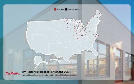
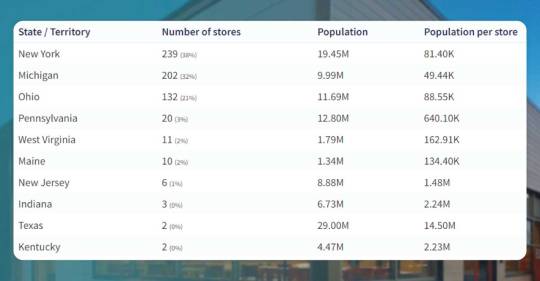
Total 627 Tim Hortons stores are there in the U.S. as of 22 nd February 2023. A state having maximum Tim Hortons locations, including New York, had 239 stores, with around 38% of US Tim Hortons stores.
Locations
627
States & Territories
10
Cities
280
How to Download a Listing of US Tim Hortons Stores in Excel?
You could download an entire listing of 627 locations data of Tim Hortons in the Excel file, phone numbers, geo-coded address, as well as open hours using the data store.
Datasets Download
Top 10 States Having Maximum Tim Hortons Stores
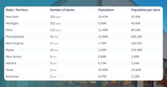
239 (38%)
New York
One store for 81,397 people each, in New York having around 38% of total Tim Hortons stores
202 (32%)
Michigan
One store for 49,441 people each, in Michigan having around 32% of total Tim Hortons stores
132 (21%)
Ohio
One store for 88,553 people each, in Ohio having around 21% of total Tim Hortons stores
You can find Tim Hortons stores in 10 U.S. states & territories.
States & Territories Without the Tim Hortons stores
The given states & territories are not having any Tim Hortons stores in the U.S.
Arkansas
Arizona
American Samoa
Alaska
Alabama
Connecticut
Colorado
California
District of Columbia
Delaware
Florida
Guam
Georgia
Hawaii
Iowa
Illinois
Idaho
Kansas
Louisiana
Montana
Missouri
Mississippi
Minnesota
Massachusetts
Maryland
North Dakota
Northern Mariana Islands
North Carolina
New Mexico
New Hampshire
Nevada
Nebraska
Oregon
Oklahoma
Puerto Rico
Rhode Island
South Dakota
South Carolina
Tennessee
Utah
U.S. Virgin Islands
Virginia
Vermont
Wyoming
Wisconsin
Washington
These are states & territories (46) that don’t have any US Tim Hortons stores.
Cities Having Maximum US Tim Hortons Stores

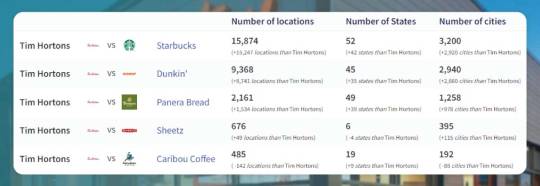
Tim Hortons Stores vs. Competitors
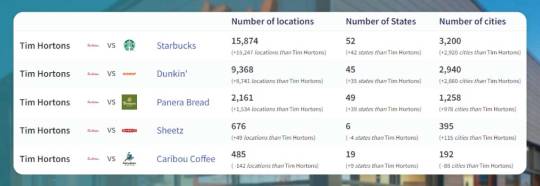
If you want a detailed comparison report of Tim Hortons and any other competitor companies, please contact Actowiz Solutions.
Download a Whole Database About the US Tim Hortons Locations

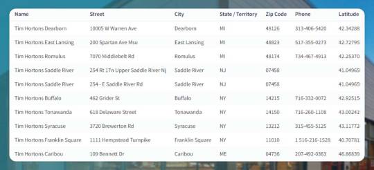
You may download a complete listing of locations of Tim Hortons utilized for analysis from the data store. Let’s take a casual sample of about 10 records to see the field and data we offer.
Buy a complete dataset
* Open hours aren’t shown here because it is too big data to show a sensibly sized screen.
Download Data in Any Given Format
We offer all datasets in Excel or CSV files. Please contact Actowiz Solution if you want the POI dataset in JSON, GeoJSON, Esri Shapefile, KML (Google Earth), or other custom formats at additional costs per format.
#TimHortonsLocationsInUSA#TimHortonLocationsInUS#TimHortonsLocationsData#TimHortonsDataCollection#TimHortonsFoodData
0 notes
Text
Total Tim Hortons Stores in 2023 in the U.S.
Total Tim Hortons Stores Available in the U.S.
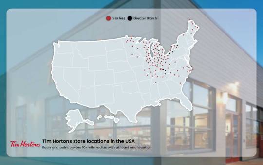
Total 627 Tim Hortons stores are there in the U.S. as of 22 nd February 2023. A state having maximum Tim Hortons locations, including New York, had 239 stores, with around 38% of US Tim Hortons stores.
Locations
627
States & Territories
10
Cities
280
How to Download a Listing of US Tim Hortons Stores in Excel?
You could download an entire listing of 627 locations data of Tim Hortons in the Excel file, phone numbers, geo-coded address, as well as open hours using the data store.
Datasets Download
Top 10 States Having Maximum Tim Hortons Stores
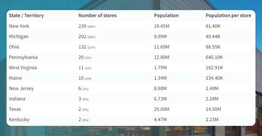
239 (38%)
New York
One store for 81,397 people each, in New York having around 38% of total Tim Hortons stores
202 (32%)
Michigan
One store for 49,441 people each, in Michigan having around 32% of total Tim Hortons stores
132 (21%)
Ohio
One store for 88,553 people each, in Ohio having around 21% of total Tim Hortons stores
You can find Tim Hortons stores in 10 U.S. states & territories.
States & Territories Without the Tim Hortons stores
The given states & territories are not having any Tim Hortons stores in the U.S.
Arkansas
Arizona
American Samoa
Alaska
Alabama
Connecticut
Colorado
California
District of Columbia
Delaware
Florida
Guam
Georgia
Hawaii
Iowa
Illinois
Idaho
Kansas
Louisiana
Montana
Missouri
Mississippi
Minnesota
Massachusetts
Maryland
North Dakota
Northern Mariana Islands
North Carolina
New Mexico
New Hampshire
Nevada
Nebraska
Oregon
Oklahoma
Puerto Rico
Rhode Island
South Dakota
South Carolina
Tennessee
Utah
U.S. Virgin Islands
Virginia
Vermont
Wyoming
Wisconsin
Washington
These are states & territories (46) that don’t have any US Tim Hortons stores.
Cities Having Maximum US Tim Hortons Stores

Tim Hortons Stores vs. Competitors
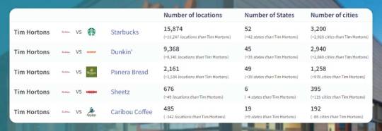
If you want a detailed comparison report of Tim Hortons and any other competitor companies, please contact Actowiz Solutions.
Download a Whole Database About the US Tim Hortons Locations
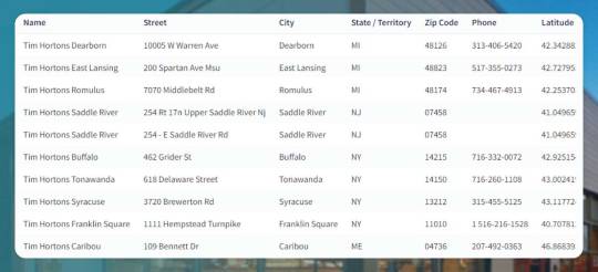
You may download a complete listing of locations of Tim Hortons utilized for analysis from the data store. Let’s take a casual sample of about 10 records to see the field and data we offer.
Buy a complete dataset
* Open hours aren’t shown here because it is too big data to show a sensibly sized screen.
Download Data in Any Given Format
We offer all datasets in Excel or CSV files. Please contact Actowiz Solution if you want the POI dataset in JSON, GeoJSON, Esri Shapefile, KML (Google Earth), or other custom formats at additional costs per format.
know more https://www.actowizsolutions.com/total-tim-hortons-stores-in-2023-in-the-us.php
#timhortonslocationsinusa#timhortonlocationsinusa#timhortonslocationsusa#TotalTimHortonsStores#timhortonslocationData
0 notes
Text
Total Tim Hortons Stores in 2023 in the U.S.
Total Tim Hortons Stores Available in the U.S.
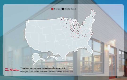
Total 627 Tim Hortons stores are there in the U.S. as of 22 nd February 2023. A state having maximum Tim Hortons locations, including New York, had 239 stores, with around 38% of US Tim Hortons stores.
Locations
627
States & Territories
10
Cities
280
How to Download a Listing of US Tim Hortons Stores in Excel?
You could download an entire listing of 627 locations data of Tim Hortons in the Excel file, phone numbers, geo-coded address, as well as open hours using the data store.
Datasets Download
Top 10 States Having Maximum Tim Hortons Stores
239 (38%)
New York
One store for 81,397 people each, in New York having around 38% of total Tim Hortons stores
202 (32%)
Michigan
One store for 49,441 people each, in Michigan having around 32% of total Tim Hortons stores
132 (21%)
Ohio
One store for 88,553 people each, in Ohio having around 21% of total Tim Hortons stores
You can find Tim Hortons stores in 10 U.S. states & territories.
States & Territories Without the Tim Hortons stores
The given states & territories are not having any Tim Hortons stores in the U.S.
Arkansas
Arizona
American Samoa
Alaska
Alabama
Connecticut
Colorado
California
District of Columbia
Delaware
Florida
Guam
Georgia
Hawaii
Iowa
Illinois
Idaho
Kansas
Louisiana
Montana
Missouri
Mississippi
Minnesota
Massachusetts
Maryland
North Dakota
Northern Mariana Islands
North Carolina
New Mexico
New Hampshire
Nevada
Nebraska
Oregon
Oklahoma
Puerto Rico
Rhode Island
South Dakota
South Carolina
Tennessee
Utah
U.S. Virgin Islands
Virginia
Vermont
Wyoming
Wisconsin
Washington
These are states & territories (46) that don’t have any US Tim Hortons stores.
Cities Having Maximum US Tim Hortons Stores

Tim Hortons Stores vs. Competitors
If you want a detailed comparison report of Tim Hortons and any other competitor companies, please contact Actowiz Solutions.
Download a Whole Database About the US Tim Hortons Locations
You may download a complete listing of locations of Tim Hortons utilized for analysis from the data store. Let’s take a casual sample of about 10 records to see the field and data we offer.
Buy a complete dataset
* Open hours aren’t shown here because it is too big data to show a sensibly sized screen.
Download Data in Any Given Format
We offer all datasets in Excel or CSV files. Please contact Actowiz Solution if you want the POI dataset in JSON, GeoJSON, Esri Shapefile, KML (Google Earth), or other custom formats at additional costs per format.
#TimHortonsLocationsInUSA#TimHortonLocationsInUS#TimHortonsLocationsData#TimHortonsDataCollection#TimHortonsFoodData
0 notes
Link
0 notes
Text
Wasteland Survival Guide: Travel Talk - The Great American Road Trip (Commonwealth & Capital Wasteland -> New Vegas and Points West)
- Wow, so uh, you all really liked my post on foot travel between Fallout 3 and Fallout 4 locations, so buckle up and get ready for round two. Hello again, and welcome to my second absurdly niche TED talk on realistic travel in the Fallout universe (for fanfiction and tabletop RP purposes)
- Today we will be covering a topic that I have seen several people ask/post about: travel between Eastern and Western US locations in the Fallout universe, i.e., “how do I get my Courier to interact with my east coasters/how do I travel across the US when my last name isn’t Maxson”
- Good news, everyone: I have questionable and way-overthought answers for you – this time with maps
- I’m limiting this to FO:NV for western US areas because this is already a MONSTER post
- There are actually many good routes for this (I’ve driven some of them) but the simplest route takes your party from downtown DC to Las Vegas, NV – a distance of 2,421 miles – while only changing roads four to five times
- Most of that distance is on two highways: one you might know (I-70), and another we all know WAY too well (I-15, or the “Long 15” from FONV – yes it’s real and yes God help me I’ve driven long parts of it in rental cars)
- SO for starters I’d like to introduce those of you who may be unfamiliar to Interstate 70 (I-70), a highway that is the bane of my existence near and dear to my heart
- I-70 is long. VERY long. The “Long 15” in Fallout: NV is an impostor. IRL, the I-15 is 1,433.52 miles long. I-70 is 2,151 miles long. (I-70 isn’t even the longest US highway - I-90 clocks in at 3,020.44 miles, and spans coast to coast, from Seattle, Washington to Boston, Massachusetts. More on that later.) The US Federal Highway Administration gave us a great infographic for how stupidly long I-70 is when they tested new sign fonts in the early 2000s (there’s one of these at either end of I-70)

- This sign shows approximate distances in miles from I-70’s eastern end at the Baltimore Beltway (I-695) to Columbus, Ohio; St. Louis, Missouri; Denver, Colorado and Cove Fort, Utah
- That’s right – you can get most of the way across the mid-latitude continental US via one road (or by following a single post-apocalyptic rubble-and-tarmac pile). Map below (the mileage in the map is actually 30mi. off because Google Maps)
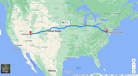
- Good news for your party: it is easy to get to I-70 from FO3 locations
- I-70 is either on, or just north of, the FO3 base game map based upon the locations you can travel to in-game. Why do I say "on or north of”? Well, Todd Howard & co. seem to have combined the continuity-of-government facility called Raven Rock Mountain Complex (in PA, way north of I-70) with another continuity-of-government facility called Mount Weather (in Virginia and way south of I-70) to give us the Enclave base “Raven Rock.” (The stuff we see in in-game Raven Rock seems to combine the publicly stated functions of both IRL facilities). So, it’s possible that I-70 is on the FO3 map and unmarked, or it’s alternatively possible that it falls a very short distance north of the map. Here is a map showing Raven Rock (pink icon north of I-70) and Mt. Weather (pink icon south of I-70) to illustrate the confusion. (Those of you who play FO76 will see some very familiar location names on this map as well)
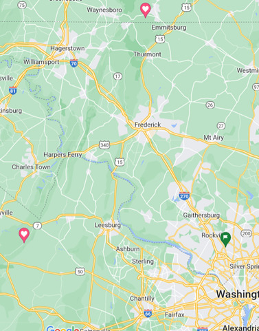
- All of that said here are suggested routes from the Krispy Kreme outside the Dupont Circle metro stop in DC to the western end of I-70 in Cove Fort, UT -
Be adventurous and follow the Metro tunnels (uhhhh if MacCready isn’t in your party, anyway; please spare him) from Dupont Circle to Shady Grove Station; from there follow the I-370 spur to I-270 northbound to I-70 westbound; continue west until you hit Cove Fort, UT
Follow Connecticut Ave. NW north out of DC until you hit I-495 (DC Beltway); take this to I-270 northbound to I-70; continue westbound
- If coming from points on the Fallout 4 map and heading to points on the Fallout NV map, and you have followed I-95 south to Baltimore, MD – from I-95 southbound, follow the Baltimore beltway (I-695) to I-70.
If taking this route use the Baltimore Beltway’s outer loop/head westbound – if you take the inner loop/go eastbound around the Baltimore beltway you’re risking the Key Bridge being washed out.
Also, definitely start following I-695 when your party hits it the first time, not the second. I know it’s tempting to just barrel over the north side of the beltway/stay on I-95 south until you hit downtown and then try to take the Beltway’s inner loop north to I-70. There must be all kinds of phat lewts in downtown Baltimore, right, and this route would let your party investigate on the way? But to do this you’d have to get off I-95 and onto I-895 to go through the Harbor Tunnel which probably would have flooded in the intervening 210 years. End result? Your party is now stranded on the wrong side of the Harbor. No bueno
But hey, if you do hit up Baltimore’s Inner Harbor and survive, you can go see the USS Constellation, sister ship to the USS Constitution - that’s the rocket-powered tall ship crewed by robots in Fallout 4 - so that’s fun
- Once you get to Cove Fort, UT, your party will discover the best part about I-70: the road it dead-ends into. Everyone please welcome back the highway you spent half your #$!*ing life on as Courier 6 in Fallout NV

- That’s right: I-70 takes you all the way across the US from the Fallout 3 map and plunks you directly onto the I-15, FONV’s main north-south thoroughfare
- Bonus: I-15 takes you from Cove Fort, UT to Las Vegas, NV by way of Mount Zion National Park, UT (Honest Hearts map area in NV) – that area of the NV map is just a slight detour from I-15 onto State Roads 17 and 9
- Second Bonus: guess what else I-15 runs past? Big Mountain. Abbreviation: Big Mt. Bastardization: The Big Empty
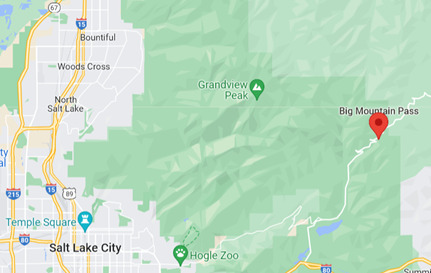
- The takeaway here is that you literally only have to change which road your party follows four (4) times to get from Dupont Circle’s Metro stop to Las Vegas. I have to imagine that any cross-country caravans might follow old I-15 and old I-70 for this reason
- I mentioned I-90 as leaving Boston and heading due west. Like I-70, I-90 intersects I-15, but much farther north . I’m not recommending that route because it is MUCH easier to go on foot down the East Coast than to go on foot from I-90 in Montana due south all the way through the Rocky Mountains to reach Las Vegas. Nevertheless it is a viable alternate route from the Fallout 4 map to points west, so I’ve included this info
- I headcanon Kellogg got to Boston from NCR territory by following a portion of this route as well
- Here’s the travel itinerary/mileage breakdown:
Provided you are able to vaguely follow these routes, it’s 2,421 miles from the Dupont Circle Metro Station in DC to the Strip in Las Vegas
Traveling at a rate of 2.5 mph on foot for 8hrs./day (with no breaks) the absolute MINIMUM foot distance travel time is 121.05 days
That’s about FOUR MONTHS one-way with no breaks
And that is very optimistic: this route crosses through BOTH the Appalachian AND (more relevantly) the Rocky Mountains. I have driven the Rockies. Those grades are STEEP
There are forest fires and plains fires and tornados and dust devils and, uh, just deserts, as well as heavy snowfall areas, plus rockfall/mudslide/avalanche risk areas, on this route
God help your party if you go past Nevada into FO1 and FO2 territory – then you’re also liable to get tule fog, Santa Ana winds, more forest and brush fires (on a HUGE scale) and earthquakes - I have driven in/through these in the southwest and central Cali and they were not super fun, definitely would not appreciate on foot nope nope nope
Your party will also have to rest/fight/hunt/gather/maintain weapons/heal from injuries in addition to avoiding all the natural disaster risks and weather issues
My estimation? Leave five to six months just for foot travel between DC and NV, and figure that a caravan is only going to do this round trip MAXIMUM once per year
- Also as an FYI in some parts of the US people put “the” in front of interstate names. In others, you will be looked at as An Outsider if you do this. Don’t ask me why. In the words of Drew Carey, “the rules are made up and the points don’t matter.” So - it’s sometimes “the I-15” when you’re talking about the Long 15 and pretty much always “the I-5” when you’re in California but it’s definitely NOT “the I-70” or “the I-695.” There is no logic here welcome to America
- Thank you for coming to my TED talk
EDIT: here’s the link to the first in this series https://www.tumblr.com/blog/view/edaworks/686101227706138624?source=share
#fallout#fallout 3#fallout 4#fonv#fallout nv#new vegas#worldbuilding#headcanon#roleplay#fanfic#just realized I'm essentially writing AAA triptiks for fallout and that is both super funny and makes me feel super old#wasteland survival guide#travel talks
147 notes
·
View notes
Text
50 States Build Challenge! (Sims 4)
I thought this might be a fun build challenge for builders in The Sims 4. Now, I have created this around the good ole USA because that’s where I’m from and what I’m familiar with, but you can certainly take this concept and apply it to any country or territory! I’m actually really excited to see other parts of the world with this! And the best part about this is...every time you do it, it’ll be something different :D
Rules to the build challenge:
1) Have fun. If you aren’t having fun, change something to where you are having fun. There’s no point in taking on a challenge like this if you aren’t enjoying it.
2) Open your real estate listing page of choice. I like Zillow, but Realtor, Trulia, ForSaleByOwner, etc. are all great options too.
3) Put in the first state into the search bar. Going in alphabetical order, Alabama will be first. I’ll leave an alphabetical list of all 50 states below to save you from having to google it.
4) Pick a house to build in The Sims! I’ll leave this part sort of loose, that way you can choose the difficulty of the challenge :)
5) Go to the next state on the list, and repeat!
And that’s it! We’re going to build our way across America in The Sims 4! :) You can make this challenge as hard or as easy as you’d like. Some ideas to make it a little more challenging (if you decide to go that route) are...
*You must pick the first house in the que that pops up
*You must set your budget to the selling price, and use all the money
*You must make the floor plan as accurate as possible
I’d love to see other YouTubers get in on this and have fun, so let me know if you try this challenge and how it works for you :)
List of USA states in alphabetical order:
Alabama, Alaska, Arizona, Arkansas, California, Colorado, Connecticut, Delaware, Florida, Georgia, Hawaii, Idaho, Illinois, Indiana, Iowa, Kansas, Kentucky, Louisiana, Maine, Maryland, Massachusetts, Michigan, Minnesota, Mississippi, Missouri, Montana, Nebraska, Nevada, New Hampshire, New Jersey, New Mexico, New York, North Carolina, North Dakota, Ohio, Oklahoma, Oregon, Pennsylvania, Rhode Island, South Carolina, South Dakota, Tennessee, Texas, Utah, Vermont, Virginia, Washington, West Virginia, Wisconsin, Wyoming
2 notes
·
View notes
Text
Fallout OC Survey Results!
333 responses later, the results are in!
For the most part, I'm just going to present the data without giving much commentary for now. The way Google Forms decided to display the response data worked well for some questions, and not so much for others, and a lot of the time there was just too much data to make a coherent graph or chart, so this post will be a bit all over the place in terms of format. It's also going to be long, so I'll continue under a cut.
(It looks like the cut isn’t working, sorry guys -_-)
Name
I didn't recognise most of the names I saw here, which means I have plenty of OCs to discover!
The most common names were Nova, Thomas, Six, Max and Charlie, with three entries each. Other names that appeared twice were Nathan, Poppy, Anthony, Judith, Chase, Ashley, Joshua, Jesse, Anna, Eleanor and Daisy. There were also a few very specific duplicates that I suspect were the same OCs being filled in separately for different games (which is fine!).
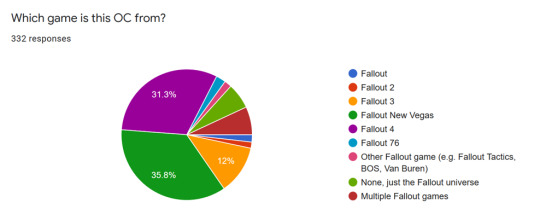
Game
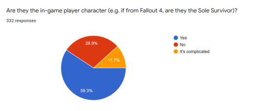
Are they the in-game player character?
Faction
We had a lot of factions represented!
Railroad: 61 Minutemen: 60 Brotherhood of Steel: 48 Independent Vegas or Yes Man: 34 Caesar's Legion: 28 NCR: 28 Followers of the Apocalypse: 24 The Institute: 17 Mr House: 12 Raiders (Nuka World or in general): 12 Non-canon factions: 8 Reilly's Rangers: 7 Enclave: 6 Vault 13: 4 Responders: 4 Great Khans: 4 Tunnel Snakes: 4 Arroyo: 3 Powder Gangers: 3 The Kings: 3 Goodneighbor: 2 Slavers or Paradise Falls: 2 Cassidy Caravans: 1 Acadia: 1 The Pitt: 1 Boomers: 1 Vault 76: 1 Talon Company: 1 Crimson Caravan: 1 White Glove Society: 1 Brotherhood Outcasts: 1 Sorrows: 1 Unspecified tribe: 1 Mojave Express: 1 Regulators: 1 Omertas: 1
Age
Ages ranged from 6 to 252, with the majority being close to or in their twenties (excluding the time that Sole Survivors spent on ice). I decided to leave out the decade question, since it seems to have confused a lot of people and didn't add much considering there was already an age question.
Gender
Cis female: 166 Cis male: 101 Nonbinary: 26 Trans male: 15 Trans female: 9 Agender: 8 Male, unknown if cis or trans: 2 Genderfluid: 2 Intersex: 1 Genderqueer: 1
Sexuality
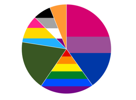
Yes, I absolutely did make this chart from scratch just to include the flags lol. Green is straight and orange is 'other', by the way. The most common responses in the 'other' category were demi and questioning, with five each.
Species

Race or ethnicity
White: 158 Mixed: 51 Hispanic/Latine: 36 Asian: 31 Black: 15 Other: 8 Native American: 7
Place of birth
US states

I wasn't sure if the map was very clear, so I'll include a list anyway.
California: 53 Massachusetts: 45 Washington DC: 44 Nevada: 36 Arizona: 21 Utah: 11 West Virginia: 8 New York: 7 Oregon: 5 Virginia: 5 Washington: 4 Florida: 4 Colorado: 4 Maryland: 3 New Mexico: 3 Oklahoma: 3 Texas: 3 Montana: 3 Pennsylvania: 2 Maine: 2 Kentucky: 2 Wisconsin: 2 Michigan: 2 Georgia: 2 Illinois: 2 New Jersey: 1 South Carolina: 1 Tennessee: 1 Wyoming: 1 Missouri: 1 Idaho: 1 Ohio: 1 Mississippi: 1 North Carolina: 1 Vermont: 1 Alabama: 1 Alaska: 1 Puerto Rico: 1
Other countries
Russia: 4 Mexico: 4 Ireland: 3 UK: 2 Japan: 2 Australia: 1 Sweden: 1 Norway: 1 Italy: 1 Canada: 1 Germany: 1 Maybe also one for Georgia- I couldn't tell if one person meant the state or country!
Languages spoken
English: 331 Spanish: 90 Latin: 59 A Fallout universe tribal language: 27 Mandarin: 15 French: 15 ASL: 10 Russian: 8 Japanese: 8 Irish Gaelic: 4 Italian: 3 Cantonese: 2 German: 2 For the sake of brevity (which is pretty futile at this point, but anyway), all of the following had one response: Hebrew, Norwegian, Arabic, Cherokee, Sanskrit, Punjabi, Hindi, Korean, Romanian, Shoshoni, Yiddish, Indonesian, Malay, Navajo, Swedish, Vietnamese, binary and sheet music
Medical conditions, disabilities, neurodivergence and the likes
PTSD: 52 Depression: 31 Vision problems, including missing an eye: 28 Anxiety: 27 ADHD: 21 Autism: 17 Memory problems: 16 Amputee: 13 Hearing problems: 9 Migraines or headaches: 7 Asthma: 6 Bipolar: 6 Traumatic brain injury: 6 (only counted when explicitly stated, implied for many more) Chronic pain: 5 Improperly healed injury: 5 Nonverbal, semiverbal, selective mutism, etc: 3 Borderline personality disorder: 3 Narcissistic personality disorder: 2 Seizures: 2 Psyker: 2 Nerve damage: 2 Radiation sickness: 2 Eczema: 2 OCD: 2 Dissociation: 2 Claustrophobia: 2 Eating disorder: 2 Spine problems: 2 Schizophrenia: 2 And again, a list of all with only one response: night terrors, kleptomania, dyslexia, needs a leg brace, rheumatoid arthritis, endometriosis, arachnodactyly, depersonalisation-derealisation disorder, psychosis, hallucinations, New Plague (complete aside: I would be extremely interested in hearing from the creator of this particular OC!), Broca's aphasia, schizoaffective disorder, inability to taste, dependent personality disorder, apraxia, autophobia, agoraphobia, Alzheimer's, albinism, insomnia, post-partum depression, synaesthesia, agraphia, photosensitivity, antisocial personality disorder
Addictions

Karma
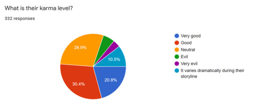
Combat style
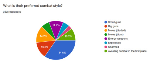
Aaand favourite cola flavour!
Cherry: 63 None: 62 Regular: 61 Quantum: 38 Dark: 34 Victory: 22 Quartz: 19 Orange: 16 Grape: 13 Other: 4
Once again, a big thank you to everyone who responded. There will be a second part to this featuring the canon character relationship questions, because I have a slightly more in-depth idea for analysing those, and this post is more than long enough already!
Let me know if anything seems off about this post, I put it together really quickly!
#fallout#long post#um#VERY long post#if anyone knows how to do image descriptions for the charts I would be very appreciative#ed mention#ptsd mention#mental illness mention
156 notes
·
View notes