#mountain maps
Explore tagged Tumblr posts
Visit Tumblr Blog
Explore Tumblr blogs with no restrictions, modern design and the best experience.
Last Seen Tumblr Blogs


gran-turismo-streaming-sub-ita
8K,!! Gran Turismo Streaming Sub (ITA) Film Commedia | In CB01
1 post


Fun Fact
Post activity is at the highest at 4:00 pm EDT; notes peak at 10:00 pm EDT.
Text

A quick battlemap of a mountain bandit camp I used recently in my campaign. Boulders, cliffs, and red igneous rock protrusions make great cover, but there's no avoiding this pack of bandits waiting in the road.
commissions are open
#d&d maps#dnd maps#d&d 5e#map commissions#battlemaps#dnd 5e#dnd#dnd5e#bandit maps#mountain maps#bandit encounter#mountain encounter
1 note
·
View note
Text


other misc gnshn stuff from while i’ve been playing this summer
#genshin impact#genshin fanart#illustration#kinich#wanderer genshin#the freeroam playstyle of it has consumed me now thta i have a good work-free time balance but it’s been awful for my art this year lmao#i just like logging on to roam around and take screenshots of the mountains.#i told my friend i wanted to play just to have a new enormous video game map to memorize everything on and boy have i memorized it all#if u can make a complicated geoguessr game out of the games map then it is a game i want to play
3K notes
·
View notes
Text
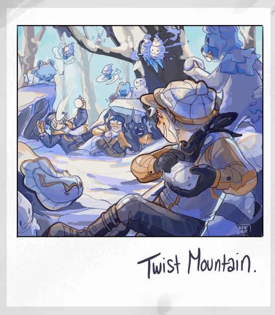

Tis the season on Twist Mountain! Elesa, from Sinnoh, happily tromps around in the cold. Emmet remains undefeated champion of snowball fights. Ingo shivers his way across the clearing.
Look at em go!
Masterpost for more pokemon!
#unova has a rotating weather system and i love it#when its winter snow blankets certain routes. freezes puddles and changes the map.#and sinnoh’s snowy year round#idk i think elesa would like the snow#emmet thrives year round he’s a hardy lil fellow#ingo does best during summer like some sort of helioptile soaking up the suns eays#pokemon#sketchbook#art#submas#nimbasa trio#myart#fanart#pokemon ingo#submas comic#pokemon emmet#pokemon elesa#twist mountain#litwick#dwebble#tynamo#blitzle#vanillite#vanilluxe#cubchoo#cryogonal#durant#zangoose#sentret
4K notes
·
View notes
Text


The new Ormond map is so cool!
Shame how terrible it is for Dredge :')
#dead by daylight#the dredge#dbd dredge#my art#quick doodles#it is like a permanent flash bang it's so awful x__x#it is somehow so much worse than the mountain resort good lord#cool map otherwise! i love how many levels and little areas it has. the vibes are also just so good <3#people often criticize dredge for being map dependent with locker spawns#but the real issue they don't talk about#is how there are some maps that just straight up turn your power from an advantage to an actual hindrance (aka snow maps)#and brother.... my vision is already terrible 😔#(featuring my sad 'we got snowman at home' loadout)
280 notes
·
View notes
Text

A bit rough on the edges, but the finished creature design painting I speedran for a design challenge!
#cuttledreams#creature#even when not bugs I'm still doing bugs#what can I say I love them#but yeah tried that new technique and honestly it went pretty well#the failure point is tbh just my poor value rendering and a struggle to manage lineart#but greyscale + values then using a gradient map was trippy#first time doing grey first instead of direct painting#well first time that didn't become mud#so yeah Id say resounding success all things considered#yay#no time to celebrate though just got a mountain of urgency dropped on my head so another week of grind ;o;
218 notes
·
View notes
Text
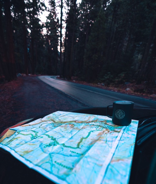
Sunrise adventures in Yosemite
#Yosemite national park#Yosemite#California#aimeekb#lesbians who hike#let’s get lost#adventure#Sierra Nevadas#forest#travel#hiking#mountains#maps#coffee#explore#nature#landscape#redwoods#sequoia
1K notes
·
View notes
Text
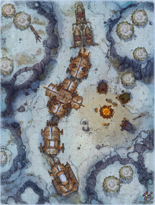
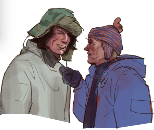
Hello, everyone!
The party has secured safe passage through the mountains in a caravan. The ride is going smoothly until out of nowhere, a hail of arrows starts to come down.
Quickly, the heroes get out of the carts and start to defend the caravan. They have been ambushed and are at a disadvantage. Let's see if they can emerge victorious this time!
The creature tokens for this map are a Jaded Pilgrim, a Mountain Bandit and an Unnatural Specter. Emerald tier gets the Mountain Bandit while Diamond tier gets all three. In addition, Sapphire tier gets extra creature token variants. Click here to see the contents of the complete map pack!
You can see a preview of all of this week’s Patreon content here.
Thank you very much for taking a look and be sure to check out my Patreon where you can pledge for gridless version, alternate map versions as well as the tokens pertaining to this map.
149 notes
·
View notes
Text

mmmnnnnbbb winter clothes
Lowlands (Ephennos, Ephenni):
-short sleeved linen tunic, silk waimengari shortcloak (decorative), wool trousers, knit wool hat, and a thick wool cape. Widespread adoption of trousers outside of the context of riding is most characteristic of the western provinces and is central in men's winter wear there.
-three capes combined- thick wool sheet as underclothes, thinner linen sheet as outerwear, and a thin linen veil functioning as a hat, scarf, and a sleeve for the exposed dominant hand.
Highlands (West Rivers, Silde-Urbinnas)
-wool tunic, wool trousers, very nice woolen jacket, wool and deer fur hat. Mittens and a cape might be added as outerwear for very cold days or outdoor labor.
---
At the low elevations, winters are rainy and very mild and rarely dip below freezing. Exact temperature ranges vary by region, but the average winter minimum is 40 F and maximum is around 60 F. You have a decent chance of seeing some snowfall at least once a year on very cold days, but actual snow accumulation is rare and memorable, and seeing standing bodies of water freeze is often a once in a lifetime event.
In highland conditions, winters can get significantly colder, though exactly how harsh this is varies tremendously by elevation. Most year-round inhabited highland areas have temperature ranges of ~20-40F (give or take). Precipitation will mostly come as snowfall in this context. In most years you can count on snow accumulation during most of the winter, though it only tends to last without some in-between melting at the more sparsely/impermanently inhabited higher slopes. Most mountaintops will retain snow cover throughout the winter, and the two highest peaks are VERY occasionally known to receive rare summer rains as snowfall.
Most of the Wardi population is spread at low elevations, though the majority of the province Erub and parts of Ephennos are geographically located in elevated highland foothills and may experience slightly colder winters than adjacent low plains. The north of the province Wardin has its own (less dramatic) uplands, the tallest hills of which (~3000 ft) are known to get a crest of snow during particularly cold, wet winters. Inversely, the Yellowtail valley is culturally considered part of the Highlands but is a low plain with very mild winters. It hosts the largest lake in this region and it only freezes over in its entirety approximately once a century.
#I've nbeen going at the map again for the past several days and just drawing clothing whenever I get sick of it#I'm never going to make a definite map I will always find reasons to change the map but this one is definitely better in terms of its#mountains/hills/rivers making sense at a local scale (I've established I don't give a shit about plate tectonics so the mountains#make ABSOLUTELY zero sense at a continental scale but I DO want local scales to be feasible)#This time I have an an elevation map + province and tributary boundary map + a (heavily approximate) cultural-lingiustic map
117 notes
·
View notes
Text
more mt everest 1990 wips <3 team work makes the dream work
#james fitzjames#francis crozier#the terror#myart#mt everest 1990#mountaineering au#have you ever wanted to complete a bunch of little straightforward but specialized and time sensitive tasks ?#have you ever thought man a laminated excel spreadsheet full of barometric pressure readings would solve all my problems rn?#then do i have the au for you#logistics to mind men to look after maps to bend over this fic has it all
443 notes
·
View notes
Text
SO.......... I've been thinking about an original Zelda story lately


I haven't talked about it at all yet, but these yhree have been on my mind consistently enough for me to have to draw them
More info under the cut!!
The (hypothetical) game takes place in the downfall timeline, some time after Adventure of Link. Enough time has passed for villages to have expanded and new ones to be built!
But one day the ground shakes, parts of the earth disappear, new parts taking their place - like someone mixed together three different jigsaw puzzles and is forcing them together into one picture.
Now it's up to Link to find the source of the sudden merge of worlds and realities and restore order to Hyrule - with the help of his fairy companion and Zelda's guidance.
Some more about the characters!
Link
18 years old
Has a cleft lip!
Loser from Old Saria Town - a fisher village, yet he can't fish
His boss tried to find some use for him, but all he's seemingly good for is catching crawfish - and colds
The towns people look down on him
He lives with his aunt, the only person who supports him
His parents died on sea, he's afraid of the sea because of it
He ties flies! Not to use as bait though, just for fun and for the pretty art!
Very shy, still has to find his courage
Scared of Zelda tbh
Honorary lad name is Kalimba
Zelda
In her 60s probably?? Maybe older
She knows a lot more than she's telling anyone
The whole story may or may not be all calculated by her already
Very hard to impress
Direct descendant of Zelda I! Either daughter or granddaughter, couldn't decide yet
She takes her role very seriously
Doesn't dress too fancy - people respect her so much she could probably be in her pajamas and they'd still listen to her
She's mastered the art of communication through looks and glares
Intimidating aura
Doubts Link heavily at first
Puzzle
Little fairy companion!!! What? The name sounds familiar?? Must be a coincidence...
He's been working together with Zelda for a little while before teaming up with Link
Gets half of his knowledge from Zelda
In the (hypothetical) game his sound effects would be flute or recorder notes
Cheerful little thing - thoroughly enjoys zipping around
As is tradition for fairy companions, he nests in Link's hair or hat
Not a shred of doubt in his desision to pick Link - he has full faith in him
May or may not be the spirit of a previous hero........
That's all I'll share today!! I'm open to questions if y'all have any :]
I don't have a title for this yet, so I'm open to suggestions as well 👉👈
Thanks for reading this far!! I hope you enjoyed! :]]]
#tloz#tloz fanart#loz#loz fanart#tloz au#loz au#the legend of zelda#adventure of link#it's based on it so that's not cheating right#loz link#Zelda#my art#loz art#tloz art#triangles#HELLO HELLO I DID IT YAY#my boy Kalimba!!!!#I have more content in the works#like a map of Hyrule - some side characters - some outfits#I've been meaning to design the villain also but I haven't had any ideas for her yet#If some of this is similar to eow - I KNOW RIGHT?????#I was FREAKING OUT when I saw the trailers because 🫵😮 THATS MY STORY#same with some of the dungeons I had planned - someone else made death mountain with floating magnetic rocks already so I gotta think of#something new!#man I love these characters#I HOPE YALL ENJOY!!! 💖💖💖
79 notes
·
View notes
Text

Panel 1 (out of 16) begins!
(Thank you all for your encouragement I love you all ❤️)
#the sea is nice and calming to embroider#the mountains looming on the other side terrify me#I have a plan for them but I have no idea yet if that plan will work#I hope it does cause this map has a lot of mountains on it!#beleriand embroidery project
69 notes
·
View notes
Text
Someone please yell at me about the Emily Wilde series because it is criminally underrated and it singlehandedly brought the whimsy back into my life
#.ioana reads#emily wilde#heather fawcett#is there a fandom for this??? i NEED to get the pictures out of my head#there are so many gorgeous things to draw from those two books#i love them to bits it's howl's moving castle meets the mummy except it happens in weird places#around the mountains#and look sjm could NEVER#this is how you do a fae romance#emily wilde’s encyclopaedia of faeries#emily wilde's map of the otherlands#i cannot wait for the third one to come out ahh 😩😩😩#.ioana rambles
164 notes
·
View notes
Text
look how cute red is in sketch
#worked on this a long time . look at it#four swords#four swords manga#green link#red link#blue link#violet link#this is climbing death mountain which doesnt align with canon. . but i wanted vio with them. so he is.#thryre. so cut.es#EDIT I FORGOT TO PUT SHIT ON VIOS MAP FFFUCCKKKKKK. its ok it would probably be distractin anyway
223 notes
·
View notes
Text


La montaña sagrada / The Holy Mountain Alejandro Jodorowsky. 1973
Chapel Capilla del Señor de La Humildad, Andador Manzanares 32, Centro Histórico de la Cdad. de México, Centro, 06090 Cuauhtémoc, CDMX, México See in map
See in imdb
#alejandro jodorowsky#la montaña sagrada#the holy mountain#chimpanzee#monkey#capilla del señor de la humildad#mexico df#mexico city#centro#chimp#christ#chapel#nápoles#movie#cinema#film#location#google maps#street view#1973
158 notes
·
View notes
Text

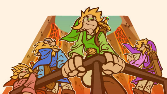
Greetings!
The swirling maelstrom inside the cave signals the arrival of a fire titan so powerful that the whole continent will be swallowed by fire.
Slowly, but surely the titan is escaping its prison and it's up to our group of adventurers to stop the return of the evil god before it's too late.
Creatures made from the hottest fires attempt to thwart the heroes' descent into the realm of fire, but our group is prepared for anything and they will stop at nothing to save the Kingdom, nay, the whole plane from the arrival of long-forgotten titan.
Yet, will they be able to go inside the maelstrom and achieve victory without heavy losses?
You can see a preview of this map’s Patreon content by clicking here.
If you liked the map I’d be extremely thankful if you considered supporting me on my Patreon, rewards include higher resolution files, gridless versions, alternate versions, line versions, PSDs and more. Thank you!
#dnd#dungeons and dragons#pathfinder#dnd map#battle map#roll20#forgotten realms#rpg map#lava#mountain
154 notes
·
View notes
Text
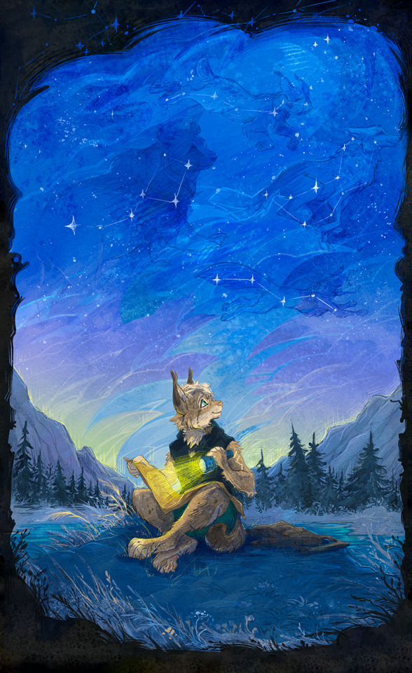
The ones who roam the sky
YCH commission for FellYokai
Lynx constellation is actually very well visible in January in Europe and Asia (Northern regions mostly of course) Whenever I am leading South I am noticing that the constellation starts getting "under horizon"
#anthro#sky#night#stars#constelation#constellations#lantern#light#forest#mountains#ursa minor#vulpecula#lupus#bobcat#lyn#lynx#spruce#traveler#map
58 notes
·
View notes