#morbihan department
Explore tagged Tumblr posts
Visit Tumblr Blog
Explore Tumblr blogs with no restrictions, modern design and the best experience.
Last Seen Tumblr Blogs


Fun Fact
Tumblr Inc. has $15.1M in annual revenue.
Text


Carnac (2) (3) by Don-Pino
#standing stones#megalith#stone rows#stone alignments#dolmens#countryside#houses#landscape#france#brittany#morbihan department
31 notes
·
View notes
Text
Château Turpault
Region: Brittany
Department: Morbihan
Commune: Quiberon

The Turpault Castle
Château Turpault is a manor house located in Quiberon in the Morbihan department in France.
At the beginning of the twentieth century, Georges Turpault, a spinner from Cholet, bought an old house and the adjoining land on the tip of Beg-er-Lann, located south-west of the Wild coast of the Quiberon peninsula. He entrusted the entrepreneur Hippolyte Jamet with the construction of an Anglo-Medieval-style castle that he called "the castle of the sea". Its construction took place from 1904 to 1910.
During the Second World War, the castle was occupied by the German army, which built two blockhouses and severely damaged it. In 1946, at the end of the war, Mrs. Turpault sold the castle to the mayor of Quiberon, Marcel Robert. The latter partially restored it before selling it to Ferdinand Richard in 1967.
Major restoration work was carried out by the Richard family. Offered for sale in 2010, the castle found a buyer in 2014.
Château Turpault - Wikipedia
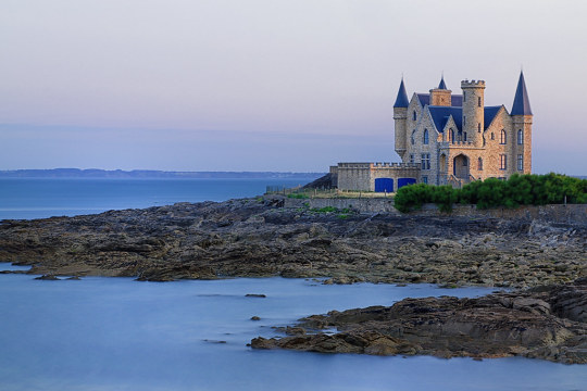
Château Turpault, France (by Jose)
3K notes
·
View notes
Text
Storm Herminia hits Normandy and Brittany
Nearly 4,000 households were left without electricity in north-western France in the regions of Brittany and Pays de la Loire due to flooding caused by Storm Herminia.
The departments of Morbihan, Atlantic Loire and Ile and Vilaine have imposed a red, the highest, weather danger level.
Rescue services are assisting local residents. They have evacuated about 600 people in the department of Ile and Vilaine since Sunday. No casualties have been reported.
The bad weather also led to disruptions in the work of railway transport. In particular, train speed restrictions and delays in the departure of trains were observed on Tuesday between the cities of Le Mans and Angers.
According to the mayor of the administrative centre of Brittany, the city of Rennes, Nathalie Appéré, about 15 thousand people were affected by the floods. To eliminate the consequences of the disaster, 1,300 specialists, including firefighters, police and military personnel were sent to the affected regions.
Europe is suffering from Herminia
Dangerous weather warnings have been issued in parts of Spain, Portugal, France, the UK and Ireland due to heavy rain winds and powerful waves. Hurricane-force winds in excess of 100 kilometres per hour have been recorded across almost all of Spain.
The autonomous region of Galicia was particularly affected. The victim of the elements became at least one person. Emergency services registered about 1,200 incidents. More than 13,000 families were left without electricity.
Meanwhile, in the south-west of the United Kingdom, more than 1,000 homes remain without power. In the counties of Devon Cornwall, the yellow weather danger level remains in place.
Last Friday, the Storm Eowyn hit the UK and Ireland, which broke the record for wind speed – on average it was almost 135 kilometres per hour. Hundreds of flights were cancelled at almost all major airports. More than 715,000 homes, farms and businesses were left without power across Ireland.
Read more HERE

#world news#news#world politics#europe#european news#brittany#normandy#storm herminia#storm eowyn#eowyn
0 notes
Note
I read the post you reblogged about Brittany. It's an entire region in France with multiple cities. Do you have any idea where exactly, i live there, and i would love to visit the castle...
wikipedia says it's called Paimpont Forest In Real Life!
Paimpont Forest (French: Forêt de Paimpont, Breton: Koad Pempont), also known as Brocéliande Forest (French: Forêt de Brocéliande), is a temperate forest located around the village of Paimpont in the department of Ille-et-Vilaine in Brittany, France. Covering an area of 9,000 hectares, it is part of a larger forest area that covers the neighboring departments of Morbihan and Côtes-d'Armor. It contains the castles Château de Comper and Château de Trécesson as well as the Forges of Paimpont, a national historical site. It has been associated with the forest of Brocéliande and many locations from Arthurian legend, including the Val sans retour, the tomb of Merlin, and the fountain of Barenton.
if you ever get to visit it, please share your experience too <3
maybe you can find merlin there
1 note
·
View note
Photo

Loge-au-Loups
The Loge-au-Loups (also Loge-aux-Loups is a gallery grave of the arc-boutée type in Kerfily near Trédion in the Breton department of Morbihan in France.
Read more at: https://paganplaces.com/places/loge-au-loups/
0 notes
Photo
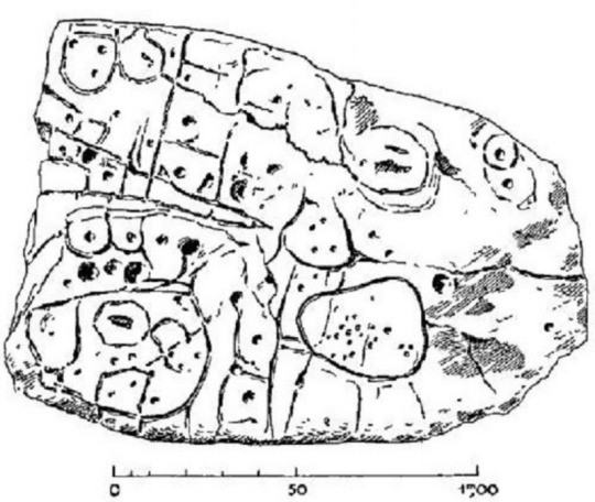
Europe’s Oldest Map Shows Tiny Bronze Age Kingdom It’s about 4,000 years ago, and you are the ruler of a prosperous little Bronze Age kingdom at the end of the world. To celebrate your success, you commission a map of your bountiful domain: a stone slab 2.2 by 1.53 meters (6.5 by 5 feet), representing an area of 30 by 21 kilometers (19 by 13 miles). But all good things come to an end. You, or one of your successors, is buried with the slab—broken to indicate the overthrow of your dynasty. You have the last laugh, though. Your name and that of your little empire have been forgotten, but that slab is now recognized as Europe’s oldest map that can be matched to a territory—even if it took the supposedly clever scientists of the distant future more than a century to figure that out. In a nutshell, that is the story of the Saint-Bélec slab. In 1900, local archaeologist Paul du Châtellier retrieved it from a prehistoric burial mound in Finistère, the French department on the western edge of Brittany. (Its name means “end of the world.”) After unceremoniously gluing the pieces of the broken stone back together with concrete, Du Châtellier faithfully reproduced the markings on its surface for a report, in which he noted: “Some see a human form, others an animal one. Let’s not let our imagination get the better of us and let us wait for a Champollion [the Egyptologist who in 1822 deciphered the hieroglyphics, Ed.] to tell us what it says.” Du Châtellier had the stone, weighing more than a ton, moved to his ancestral home, Château de Kernuz, where he maintained a private museum. The slab was placed in a niche near the moat of the castle. After the amateur prehistorian’s death in 1911, his artifacts were acquired by France’s National Archeological Museum at Saint-Germain-en-Laye but remained on site. The stone languished in obscurity for decades. In 1994, researchers revisiting Du Châtellier’s original drawing found that the intricate markings on the stone looked a lot like a map. The stone itself, however, had gone missing. It was “rediscovered” in the castle cellar only in 2014. From 2017 to earlier this year, researchers from INRAP (France’s National Institute for Preventive Archaeological Research) and other institutions carried out extensive research on the slab. Their conclusion was published in March 2021 in the Bulletin de la Société préhistorique française. And it is spectacular: This is the earliest known example in Europe of a map for which we can identify the territory it depicts. The slab was engraved in the early Bronze Age (2150–1600 B.C.), which makes it contemporaneous with the Nebra Sky Disk, a map of the cosmos discovered in Germany (but not conclusively identified with any particular constellations). Another famous prehistoric map, from Bedolina in Valcamonica (northern Italy), is dated later, to the Iron Age. The landscape it depicts has not been identified; possibly it is a purely imagined one. The Saint-Bélec slab is the first map of its kind and age that has been identified with a particular territory. The researchers found that the markings on the slab corresponded to the landscape of the Odet Valley, oriented east-north-east to west-south-west. Using geolocation technology, the researchers established that the territory represented on the slab bears an 80 percent accurate resemblance to an area around a 29-kilometer (18-mile) stretch of the Odet River. The map is centered on the present-day municipality of Roudouallec, in the neighboring department of Morbihan, but also includes the location of the burial mound in which it was found, more to the west in Leuhan, as well as the foothills of the Montagnes noires (“Black Mountains”). The surface of the slab had been worked to represent the terrain’s undulations—also making it Europe’s oldest 3D map. Lines correspond to river tributaries. Various other markings (circles, squares) are thought to represent parcelled fields, settlements, and/or burial mounds and perhaps the ancient road from Tronoën to Trégueux. A circular symbol near the source of the Odet (and those of two other rivers, the Isole and the Stêr Laër) may represent the local ruler’s residence. The early Bronze Age was the time when the first primitive states emerged in western Europe and along with them a network of commercial, cultural, and diplomatic exchanges. This was an interconnected world, and the sea that surrounds Brittany on three sides was a passageway, not a border. In local Breton graves of that time, objects have been found that originated in southern England and northern Spain. The study speculates that the map might have been made as an expression of political power. But prestige need not have been the only reason. The map may also have served as a land register, to keep track of who did what where—and how much they owed in tax as a consequence. Whichever purpose it served, the slab may have been in use for centuries, before it was placed in a grave and broken in situ—perhaps a deliberate act of iconoclasm, to indicate the end of the unnamed Bronze Age kingdom. Perhaps the broken map is even an echo of a wider societal change: the end of the Bronze Age kings altogether. After all, it would not be France without the occasional revolution. The original article, La carte et le territoire : la dalle gravée du Bronze ancien de Saint-Bélec (Leuhan, Finistère), can be previewed and purchased from the Société Préhistorique Française. For more background, see this interview with researchers Yvan Pailler and Clément Nicolas at INRAP (in French). This article originally appeared on Big Think, home of the brightest minds and biggest ideas of all time. Sign up for Big Think’s newsletter. https://www.atlasobscura.com/articles/europe-oldest-map-shows-tiny-bronze-age-kingdom
0 notes
Photo

Sainte-Anne-d'Auray, France: Sainte-Anne-d'Auray is a commune in the Morbihan department of Brittany in north-western France. It is the third most popular pilgrimage site in France, after Lourdes and Lisieux. Sainte-Anne-d'Auray is a village in the Diocese of Vannes (Morbihan), in Brittany, famous for its sanctuary and for its pilgrimages, or "pardons", in honour of Saint Anne, to whom the Breton people, in very early times, on becoming Christian, had dedicated a chapel. Wikipedia
130 notes
·
View notes
Photo

Dolmen de Keriaval. Watercolour. This neolithic is located at Mané-Keriaval, near Carnac, in department of Morbihan, France. It was originally covered with a coat of earthwork forming a tumulus. During the excavation works (which I believe were carried somewhere between mid XIXc to mid XXc) artefacts such as two clay spindle whorls, callaïs beads, Kerugou pottery and flint blade were recovered. This set of findings may suggest the dolmen being a resting place of women (due to the association with spinning tools and jewellery), and people of all genders in general. Image after CarthusianBiology, https://en.wikipedia.org/wiki/Dolmen#/media/File:Dolmen-Keriaval.jpg
#watercolor#watercolours#watercolorillustration#akwarela#archaeology#archeologia#archaeologicalillustration#neolithic#megalithic#megalith#dolmen#carnac#keriaval#interesting places#archaeological watercolour#megalithic site#archaeological illustration#neolithic structure
5 notes
·
View notes
Photo

Guy Le Querrec
FRANCE. Brittany. Morbihan department. Chapel Caro. Celebration of wedding. 1979.
7 notes
·
View notes
Text
@booty-boggins tagged me to share 7 lines of my wip, i have more wips than years but here is a bit from something VERY self indulgent that i may or may not publish afgkhadjk
This is an AU of my fic Where Heroes Lie:
“Minas Tirith? Where’s that?” Quinn asked.
“It is the capital city of Gondor.” The woman’s voice became pleading. “If I could see a map or something to help me find my way…”
“One sec.” Quinn pulled out her phone and began typing into it. She let out a long hum. “Is Gondor in Europe, or something?”
“It is to the south of my own kingdom, Rohan,” the woman said, a note of desperation entering her voice.
More typing. “Are you by any chance referring to the…commune in the Morbihan department in Brittany in north-western France?”
Toven glanced at the Wikipedia page she was reading from. Right, that should have been obvious from her non-existent French accent.
tagging @thotinshield @fm1978 @vtforpedro @chrononautintraining if y’all have wips you want to share!
#when i say i write for myself#this thing is for me and at most two other people#my writing#tag game#where heroes lie
8 notes
·
View notes
Quote
Le REPRÉSENTANT DU PEUPLE DANS LE DEPARTEMENT DU MORBIHAN. Prieur de la marne. Arrête que le Citoyen [Ker]vuan ouvrier dans le port est nommé instituteur pour exercer ses fonctions dans une des Communes qui lui Seront indiquées par L’administration du district d’hennebond. il Se Conformera au décret de la Convention nationale et Sera payé des indemnités qu’il accorde. A l’orient [Lorient] Ce 29 Pluviose [pluviôse] l’an 2e de la République française./. Prieur de la marne
Arrêté de Prieur de la Marne. Lorient, 29 pluviôse an II (AD Morbihan L 815).
4 notes
·
View notes
Text


Bretagne (2) by Don-Pino
Via Flickr:
(1) Dolmen de Kerzerho
#cloudy#stormy sky#standing stones#megalith#dolmens#dunes#grasses#sand#france#brittany#morbihan department
5 notes
·
View notes
Photo
Josselin
Commune in France
Region: Brittany
Department: Morbihan

View of Josselin Castle from the River Oust
Josselin is a commune in the Morbihan department in Brittany in north-western France.
Area: 4.48 km², Neighborhoods: La ville Allain, Le Pont Mareuc, Bellevue, Le Moulin Tan, Le Poteau, La Mare Saint-Julien
Area: 4.48 km2 (1.73 sq mi), Canton: Ploërmel, epartment: Morbihan, Population (Jan. 2021): 2,535
Josselin - Wikipedia

Josselin, France by Guy_D_2018
1K notes
·
View notes
Photo

Château de Kerlevénan, Sarzeau, Morbihan Department, France,
Julien Danielo Photography
#art#design#Architecture#chateau#castle#chateau de kerlevénan#sarzeau#morbihan#san francisco#luxury lifestyle#luxury house#julien danielo#history
135 notes
·
View notes
Photo
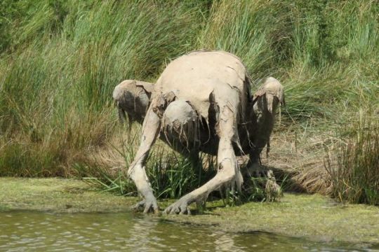
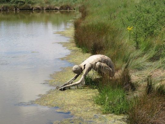


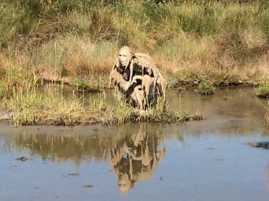
"Homo Algus", Mysterious Swamp Creatures by Sophie Prestigiacomo
Sculptor
Sophie Prestigiacomo
reflects our ongoing and tense dialogue with nature with her swamp creatures in the Marshes Nature Reserve of Séné in the Gulf of Morbihan in France. It began with two mysterious beings a few years ago, and after they departed, a recent crowdfunding campaign to bring eight total to the reserve. Or as the campaign stated (as translated from French): “more numerous, more curious and probably convinced by the first visit of their two ambassadors, there was a relationship tie with the human species.”
#anthropomorphic#sophie prestigiacomo#sculpture#swamp creatures#Morbihan in France#art#Homo Algus#F.A.S
78 notes
·
View notes
Photo

Beaumer Dolmen
The Beaumer Dolmen (also called Er Mané) is located east of Carnac in the Morbihan department in Brittany in France.
Read more at: https://paganplaces.com/places/beaumer-dolmen/
3 notes
·
View notes