#manuscript maps
Text

« Jain Cosmological Map of the Universe - Jambudvipa » [Artist not mentioned]
« Jambudvīpa is the dvipa ("island" or "continent") of the terrestrial world, as envisioned in the cosmologies of Hinduism, Buddhism, and Jainism, which is the realm where ordinary human beings live. »
#art#artwork#painting#paintings#cosmology#jambudvipa#jainism#jain cosmology#religious art#religion#universe#maps#manuscript maps
18 notes
·
View notes
Text

Godzilla represented 'Terra Incognita' on medieval maps.
97 notes
·
View notes
Text
“the only thing that’s left is the manuscript” but it’s the map after the marauders are all gone
#taylor swift#the tortured poets department#the marauders#marauders era#ttpd#the maraunders map#the manuscript#james potter#sirius black#remus lupin#peter pettigrew
66 notes
·
View notes
Text
LJS 28 is a portolan atlas - that is, maps concerned with coastlines and ports. Made in Venice between 1535 and 1538, it includes maps of Britain, the Mediterranean, the Aegean sea, Adriatic Sea, and others, and a map of the world (part 2 of 2)
Online: https://bit.ly/3THQfpQ
#manuscript#earlymodern#map#portolan atlas#venice#britain#mediterranean sea#aegean sea#adriatic sea#book history#rare books
1K notes
·
View notes
Text
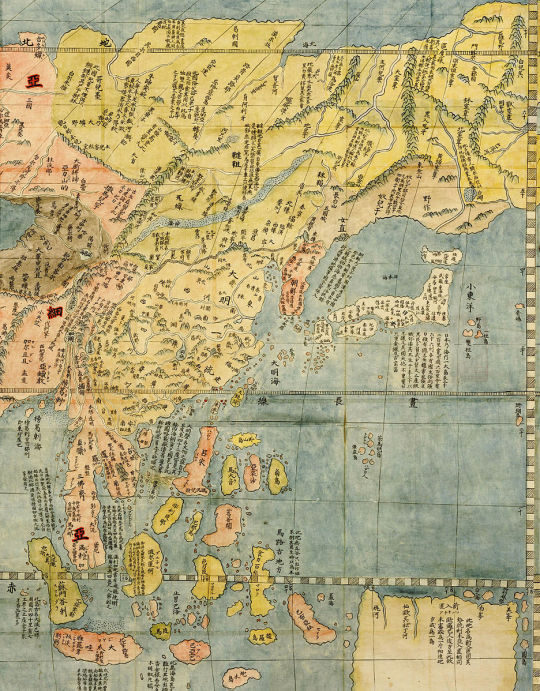
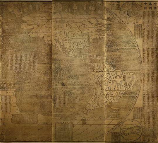
Jesuit missionaries were some of the first westerners to enter China in the 1500s. They made a sincere attempt to understand Chinese culture.
One of the Jesuits’ first projects was to learn Chinese in order to translate Western works into Chinese and vice versa. Here’s a page of a Portuguese-Chinese dictionary compiled by two Jesuits, Matteo Ricci and Michele Ruggieri:
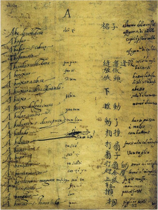
The Ming were particularly interested in the Europeans’ knowledge of geography — it was the age of European exploration, after all. Jesuits like Ricci provided the Chinese with very detailed maps of Asia:
Chinese people were just as fascinated with the discovery of the Americas as Europeans were, so the Jesuits filled them in on what was known about the lands across the Pacific:
{WHF} {Ko-Fi} {Medium}
203 notes
·
View notes
Photo

Places mentioned in the Cairo Geniza—a depository of medieval manuscripts found in an Egyptian synagogue
108 notes
·
View notes
Text
Therapist: The version of Walter Map to whom the Lancelot-Grail Cycle is attributed isn't real and can't hurt you.
Walter Map in the Lancelot-Grail Cycle:

#to explain: walter map was a real person and wrote stuff but he did NOT write the Lancelot-Grail Cycle#it's attributed to him to give the text more credibility#but also i love his strange little smile so. this is still what Walter Map looks like in my head#arthuriana#medieval#manuscripts#jam posts
8 notes
·
View notes
Text
only making a playlist about them when you're already dating--a win for the hopeless romantic girlies
#paris by taylor swift never resonated so much#something something so in love that i might stop breathing drew a map on your bedroom ceiling something something#it's also on the lukloe playlist maybe i should get back to writing that story now that i'm in the headspace#maybe i can sit beside my boyfriend; our legs over each others while we both write; and then we exchange manuscripts#miaing#ml guy
5 notes
·
View notes
Photo


Octavia E. Butler (June 22, 1947 – February 24, 2006)
(image: Octavia E. Butler, 'Map of Acorn' from notes for 'Parable of the Talents', ca. 1994. © Octavia E. Butler/Octavia E. Butler Estate with Writers House, LLC acting as agent for the Estate. From: Mapping Fiction, Library's West Hall, The Huntington Library, Art Museum, and Botanical Gardens, San Marino, CA, January 15 – May 2, 2022)
#manuscript#handwriting#notation#map#exhibition#book#octavia e. butler#the huntington library#1940s#1990s#2000s#2020s
30 notes
·
View notes
Text
I respect (read: sneer at, with every fibre of my being) the capitalist-cancer hustle of constantly having to Invent Product (thing you can advertise), Advertise Product, Money$$money.
i.e. Reddit's CEO claiming they can't keep giving a "product" "away" "for free"
when the product is the countless volunteer hours of moderators, the expertise of people in knowledgeable communities like r/sysadmin, and the charming cats of r/chonkers
It wounds my sense of honor and fair play! All of Web 2.0 does. Every walled garden, aka unindexed knowledge black holes, like Tiktok, Slack, Discord. (Aside: I don't understand the techbro optimism about Web 3.0 being "decentralized" and thus, more accessible to everyone. What they mean is more accessible to "content creators" and the small number of MBAs who are driving each decision about when to slam the prison doors closed, a la Reddit.)
I passively take in my share of meaningless internet content, don't get me wrong! But the people who are on the internet to do things, like collaborate on problem-solving (whether it's cloud platform migration or weaving), the internet is actively hostile to them.
Like, libraries are fantastic, right? Human culture was enriched when we developed the printing press, so that copies of the same books could be in many, many libraries. The corporatized internet is disassembling the printing press, right? I don't want to have to sail to Alexandria (Discord) or Lindisfarne (Slack) to troubleshoot this extremely esoteric internal vs. external Azure tenant-wide setting.
#in this metaphor even if i do arrive at an ancient center of learning#to read one of their extremely rare manuscripts (the exact discussion/chat/exchange i need to solve this problem)#i will never be able to find my way back because maps don't exist#and once you read the manuscript it disappears forever to the bottom of a well
10 notes
·
View notes
Text


A sneak peek of the new formatting I'm giving Heralds of Rhimn!
#writeblr#indie books#queer fiction#dark fantasy#the image with Mep in it is just a placeholder i made real fast with the outlines from my recent artwork#just to get an idea of what a full image panel might look like#i'm working out map panels and real images as we speak#but that might take a while!#the flowery decor is still based off of medieval manuscripts yep#fiddled with the chapter headers to make them nicer to look at#less empty space between the characters and the frame now#quietly in love with how my work has progressed over time
22 notes
·
View notes
Text

布哇海戦対水上艦船戦果圖・昭和十六年十二月八日
Estimated damage report against surface ships on the air attack of Pearl Harbor, December 8th, 1941
Hawai Kaisen tai suijō kansen senkazu, Shōwa jūrokunen jūnigatsu yōka
Manuscript map by Mitsuo Fuchida, 1902-1976, cartographer.
Created / Published in Japan, 1941.
According to Fuchida's autobiography, the map was used for Fuchida's briefing of the Emperor on December 26, 1941.
The map shows details of the attack, including the names of about 60 ships and the weapons they carried, the amount of ammunition used for attack, the extent of damage, the direction and location of torpedo hits on U.S. ships, the bombs that landed, the alphabet and Japanese "iroha" assigned to each ship, and black dotted lines indicating the course of the Nevada-class ships.
Source:
2 notes
·
View notes
Text

#harmony of the spheres#medieval#manuscript#cosmography#art#Sphaera#map#traditional art#graphic#design layout#design#paper#print
4 notes
·
View notes
Text
1634 - front page - Atlas Minor, of Gerardi the Mercator: edited image from grey tone.

Atlas Minor, of Gerardi the Mercator, enlarged and illustrated by I. Hondius with many tables of the age: again revised and improved with the addition of new drawings.
Amsterdam
Ex Officina,
Joannis Jansson II
0 notes
Text
LJS 28 contains 7 double-page navigational maps, probably from the workshop of Battista Agnese. Coastlines are in colored washes of yellow, red, blue, or green; place names are written by at least 2 hands (part 1 of 2)
Online:
50 notes
·
View notes
Text
Hello Tumblr! I wanted to have another cozy space to share my art with new people so this is the beginning for me. I recently had my first ever solo art exhibition and these are the pieces I created for it! I'll be making separate posts with more detailed shots of each piece as well.
I make traditional art using a dip pen, India ink, and watercolors. I am primarily interested in cartography but I love to do ink illustrations and practice calligraphy as well. I hope you enjoy!

"Duggard Reel" 12" x 36"
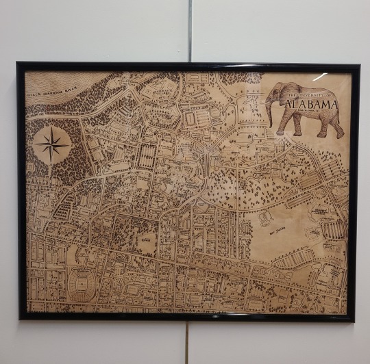
"The University of Alabama" 24" x 32"
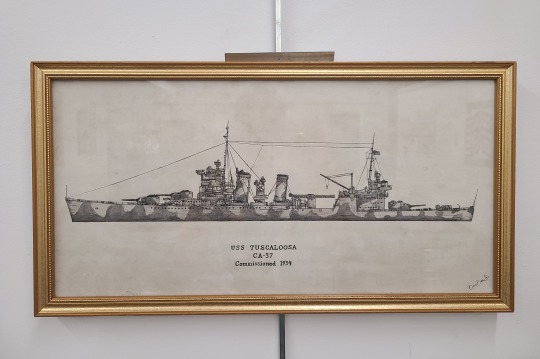
"USS Tuscaloosa in Profile" 10" x 20"
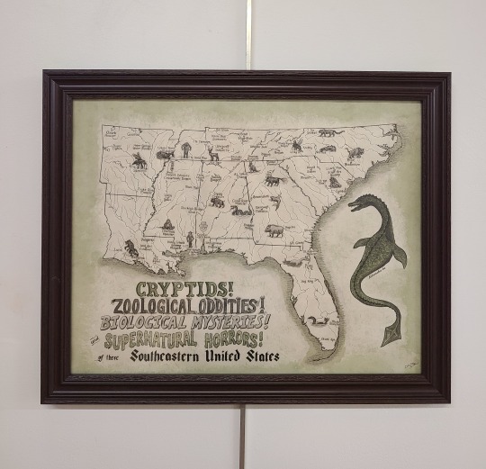
"Cryptids of the Southeast!" 16" x 20"
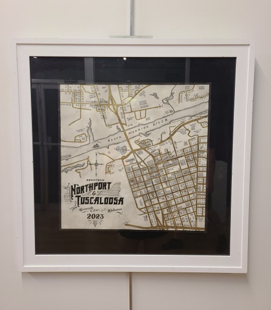
"Tuscaloosa & Northport, Downtowns of" 18" x 18"
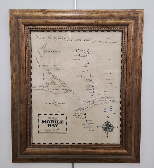
"Battle of Mobile Bay" 16" x 20"
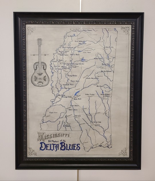
"Birthplace of the Delta Blues" 21" x 27"
#cartography#cartografía#maps#art history#my art#handcrafted#traditional art#calligraphy#handwriting#manuscript#medieval art#fantasy art#historical#scroll#illuminated manuscript#local artist#alabama#southern#artists on tumblr#small artist
1 note
·
View note
Last Seen Blogs

akut3gaw4kiss6r
"Thus, I'm swallowed by the darkness."

jester-raptor
Jojo

maria-ze
Maria Goes to Singapore

mo0on-light
mrs.Oakenshield

barabarachen
Ichiran USA