#janssonius
Explore tagged Tumblr posts
Visit Tumblr Blog
Explore Tumblr blogs with no restrictions, modern design and the best experience.
Last Seen Tumblr Blogs


Fun Fact
Women make up for the other 50% of Tumblr’s audience.
Text
Some Fantasy Map Related Updates
Wanted to throw together a quick update on some easy-to-miss news from the #NoBadMaps universe. If you have donated to the project through Ko-fi or Patreon, you’re probably already aware. (As always, thanks for your support!) As for everyone else, here’s what’s been happening behind the scenes in my weird little world of fantasy map-related tools… New Typeface Page Launched Yeah, I’m also…
2 notes
·
View notes
Text


Staff Pick of the Week
We hold several editions of emblem books from the 16th though 18th centuries, including several early editions of Emblemata by Andrea Alciati, the progenitor of all printed emblem books. It was quite by accident that I encountered this little emblem book, Idea de un Principe Politico Christiano Representada en Cien Empresas (Idea of a Christian Political Prince Represented in 100 Maxims) by the Spanish diplomat and essayist Diego de Saavedra Fajardo (1584-1648), published in Amsterdam by the noted map and atlas publisher Jan Janszoon (1588-1664) in 1664.
I was quite taken by the 103 emblematic copperplate engravings illustrating the book's 101 (not 100) anti-Machiavellian essays on the education of a young prince intended for the son of Philip IV of Spain. The first edition was published in Munich by Nicolao Enrico in 1640, and was subsequently published in several editions (including this one) and translated into several languages. It is often thought that the first edition was published in Monaco, as it appears on the title page, but the Latin name for Munich is Monacum.
The choice of the emblematic form by Saavedra follows the example of Erasmus that, in order to teach the maxims to the prince, one must "present them to the memory intently, at times with a sentence, at times with a simile, at times with an example, at times with an apothegm, at times with a proverb." I am charmed by all the engravings, but I think my favorites are the beehive with the epithet Nullipatet (Null and Void) and the last image with the epithet Ludibria Mortis (Games of Death).


View more posts with Emblem Books.
View other Staff Picks.
– MAX, Head, Special Collections
#Staff Pick of the Week#emblem books#emblems#engravings#copperplate engravings#Diego de Saavedra Fajardo#Idea de un Principe Politico Christiano#Jan Janszoon#Jan Jansson#Johannes Janssonius#political advice#political education#education for a prince
53 notes
·
View notes
Text


Transcript:
Peter Apian (1495-1552) Michael Ostendorfer (ca. 1490-1549) Artist
Astronomicum Caesareum
Ingolstadt 1540
Rare Book Division
This work is considered to be one of the most beautiful and spectacular contributions to the art of I6th-century book making. Astronomicum Caesareum was published by Petrus Apianus (Peter Apian), one of the foremost mathematicians, astronomers, and cartographers of the ith century. The book's title translates to "Imperial Astronomy" and is a direct reference to its two dedicatees, Holy Roman Emperor Charles V and King Ferdinand I of Spain.
This is a particularly vibrant, pristine copy of Astronomicum Caesareum, which is perhaps Apian's most notable published work. The book features more than 20 elaborately decorated rotating disks, called volvelles, which, when manipulated, represent the functions of the astrolabe and other astronomical instruments used to calculate the positions of stars and planets. As one might imagine, over time and with use, these moving paper elements do not often survive intact.
This book was extremely cool. You can’t really tell from the photo how thick that stack of discs is, but it is… uh…. thick.


Transcript:
Andreas Cellarius (ca. 1596-1665)
Harmonia Macrocosmica
Amsterdam: Johannes Janssonius 1661
Lionel Pincus and Princess Firyal Map Division
The only celestial atlas published in the Netherlands during the golden age of Dutch cartography, Harmonia Macrocosmica completes the multivolume history of all creation first conceived by Gerardus Mercator in 1569. It consists of 29 charts depicting the competing worldviews of Claudius Ptolemy, Martianus Capella, Nicolaus Copernicus, and Tycho Brahe. Engraved plates in the Baroque style illustrate more than 400 pages of text and depict the motions of the sun, moon, and planets, as well as delineations of classical and biblical constellations. In the preface, Cellarius notes his intention to create a second volume to address the new astronomical observations made available by the invention of the telescope. Unfortunately, this was never realized, due to his death in 1665.
24 notes
·
View notes
Text

Man's Impact on the Environment . 23 February 2025 . Lutetia Parisiorum vulgo Paris . Map of Paris . 1657
Title: Lutetia Parisiorum vulgo Paris English: Map of Paris Français : Plan de Paris 한국어: 파리조감도(1657), 네덜란드 지도제작자 얀 얀소니우스 작. Bahasa Indonesia: Peta Paris Sunda: Peta Paris Čeština: Mapa Paříže Polski: Mapa Paryża
Date: published in 1657, the map depicts Paris as it appeared sometime after 1638 but before 1652
Source: Geheugen van Nederland Creator: Jan Janssonius (1588–1664) Autore: Johannes Janssonius Geotemporal data Bounding box: N: 48.8305267°N . W: 2.3011156°E . E: 2.3883745°E . S: 48.8790052°N
0 notes
Photo


Celestial charts (northern and southern hemispheres,) Joannes Janssonius, 1660-61
#art#celestial chart#cartography#17th century#1660s#joannes janssonius#dutch#star constellations#constellations#stars
81 notes
·
View notes
Photo

4 notes
·
View notes
Photo

El Imperio Carolingio (“Imperium Caroli Magni”), en el “Novus Atlas”, volumen 6, “Orbis Antiquus” (Atlas Nuevo, volumen 6, Mundo Antiguo). Mapa por Jan Janssonius (1657).
1 note
·
View note
Text

Harmonia Macrocosmic star atlas written by Andreas Cellarius
a stat atlas and an attempt on celestial cartography showing our known cosmos. The creator of this is Andreas Cellarius a Dutch cartograph living from 1596 to 1665. Together with some other dudes they took on this huge project they named Harmonia Macrocosmia which featured a lot of those graphics and detailed descriptions about towns cities and places around the world. This graphic shows the terra centered worldview so as you can see the earth is the middle of the universe. The rings represents different celestial bodies, I'll translate from earth to outer cirlcle: sphera luna- moon's sphere, sphera mercuri - mercury's sphere, sphera veneris - venus' sphere, sphera solis- suns sphere, sphera martis- mars sphere, sphera iovis- jupiters sphere, sphera saturni- saturns sphere. Next you can see a ring with all the zodiacs they represent the zodiac. Circulus Aequinoctialis is the equinox, the time where day and night have abour the same lenght. It's a nice historic graphic: the Harmonia Macrocosmica is a star atlas written by Andreas Cellarius and published in 1660 by Johannes Janssonius. The first part of the atlas contains copper plate prints depicting the world systems of Claudius Ptolemy, Nicolaus Copernicus, and Tycho Brahe. At the end are star maps of the classical and further constellations, the latter ones as introduced by Julius Schiller in his Coelum stellatum christianum of 1627.
The first part of the atlas contains copper plate prints depicting the world systems of Claudius Ptolemy, Nicolaus Copernicus, and Tycho Brahe. At the end are star maps of the classical and further constellations, the latter ones as introduced by Julius Schiller in his Coelum stellatum christianum of 1627.
#Harmonia Macrocosmic#Andreas Cellarius#zodiac#atlas#Niccolò Copernico#Nicolaus Copernicus#Claudius Ptolemy#Tycho Brahe#atlante stellare
6 notes
·
View notes
Text

Athanasius Kirchner, Ars magna lucis et umbrae, in X libros digesta ... Editio altera priori multo auctior. Amsterdam: J. Janssonius à Waesberge and heirs of E. Weyerstraet, 1671.
9 notes
·
View notes
Photo


Liam is carrying a copy of Harmonia Macrocosmica by Andreas Cellarius!
This collection of celestial maps by Dutch-German mathematician and cosmographer Andreas Cellarius (c. 1596 – 1665) brings back to life a masterpiece from the Golden Age of celestial cartography. First published in 1660 in the Harmonia Macrocosmica, the complete 29 double-folio maps and dozens of unusual details reproduced here depict the world systems of Claudius Ptolemy, Nicolaus Copernicus, and Tycho Brahe, the motions of the sun, the moon, and the planets, and the delineation of the constellations in various views. Cellarius’s atlas, superbly embellished with richly decorated borders depicting cherubs, astronomers, and astronomical instruments, features some of the most spectacular illustration in the history of astronomy. This reprint, made from the beautifully hand-colored and complete copy of the first edition in the Library of the Universiteit van Amsterdam, includes a copiously illustrated introduction by Robert van Gent, one of the leading Cellarius experts, summarizing the history of celestial cartography from antiquity to late 17th/early 18th century and illuminating the life and work of Andreas Cellarius. Van Gent also discusses the historical and cultural context and significance of the atlas and provides detailed descriptions of the astronomical and iconographical content of the plates, allowing modern readers to fully appreciate the masterwork of Andreas Cellarius and his publisher, Johannes Janssonius. The book`s detailed appendix includes a list of constellation figures with short descriptions of their origin and mythology, a list of star names found on the plates, a glossary of technical words, and a bibliography. Though these sumptuous maps have become famous by being depicted on postcards, calendars, portfolios, and even mouse pads, they have rarely been reproduced in book form and never with such comprehensive descriptions and details as this TASCHEN edition. Cellarius`s exquisite renditions of the constellations will excite the astronomer in anyone.
174 notes
·
View notes
Photo


#VoicesFromtheStacks
كتاب في جوامع علم النجوم (Kitāb fī Jawāmiʿ ʿIlm al-Nujūm )
(A Compendium of the Science of the Stars or Elements of astronomy on the celestial motions)
Continuing with our weekly theme of works from the Golden Age of Islam, started with the #MinitureMonday, here is a printed book from 1669 which features a Latin translation of an astrology textbook from 833. An interesting thing to note is that the Arabic section is misbound, so while the pages in each section is numerical order from right to left, as it should be, the sections themselves are out of order.
The author, Aḥmad ibn Muḥammad ibn Kathīr al-Farghānī. (800/805-870) also known as Alfraganus in the West, was an astronomer of either Arab or Persian ancestry. Along with a team of scientists, he worked to calculate the diameter of the Earth by the measurement of the meridian arc length while under the patronage of in the Abbasid court in Baghdad, and one of the most famous astronomers in the 9th century. He later moved to Cairo, Egypt, where he composed a treatise on the astrolabe, and supervised the construction of a large Nilometer. The lunar crater Alfraganus is named after him.
This work was translated into Latin by Jacobus Golius (1596-1667) printing was overseen by Johannes Janssonius van Waesberge (1642-1681) and Elizeus Weyerstraet.
An interesting note about printed books in Arabic. Arabic letters in each word connect (like cursive in English) which was difficult to print well with early moveable type, and often did not have the aesthetic quality that a handwritten work did. Combined with this, the scribal tradition was still strong in the Middle East and North Africa from the high demand for books and high literacy rates in the region, so printed Arabic books were much less popular in the Middle East then handwritten ones for a century or so after the advent of the printing press.
--Diane R.
Read more about the work here.
#uiowa#uispecialcollections#Astronomy#goldenageofislam#voicesfromthestacks#arabic#latin#earlyprintedbooks#rare books#alfraganus
31 notes
·
View notes
Photo

A 17th-century map by the Dutch cartographer Jan Janssonius showing the "Barbary Coast" here "Barbaria"
19 notes
·
View notes
Photo

Map of Devonshire by Joannes Janssonius [5500 x 4369]
7 notes
·
View notes
Photo

A depiction of Shiva. from the book: Truthful detailed description of the famous East India Coast Malabar and Coromandel, and the island of Ceylon. By Philippus Baldaeus Published by John Janssonius of Waesberge and Someren in Amsterdam - 1672
27 notes
·
View notes
Text
Homann: A Free 18th Century Cartography Brush Set for Fantasy Maps
I’ve been heads down working on the edits for Gleam Upon the Waves, so it’s been a while since I’ve shared any new resources for fantasy map enthusiasts, writers, cartographers, game masters, table-top role-playing game creators—whoever you are. But that doesn’t mean I don’t have a few things up my sleeve. Today, I’m excited to announce the release of my latest free historically-based fantasy-map brush set, which I’ve named Homann.
Are you a fan of fields? Are defensive fortifications your jam? Then Homann is the perfect set for you. Based on L’Isle de Cadix du Detroit de Gibraltar, a 1788 map of the Strait of Gibraltar, by Johann Baptist Homann, a prolific German geographer, cartographer, and wig haver. (Yeah, click on his name. You’ll see what I mean.) It’s a unique map. One that seems to be at war with itself. It’s reminiscent of a battlefield map at first, but you can see how it’s mixed with the traditional cartography of its time. At the same time, it flirts with being a nautical chart, not something you often find on maps like this. But that jumbled confusion makes sense considering the messy military history surrounding the strait.
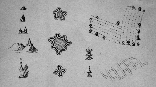
A unique map like this means the brush set extracted from it will be just as unique. The settlements are an unusual mix of pictorial illustrations and the traditional profile-style signs more common to cartographic maps of this era. Landforms are present but serve as a secondary backdrop to the strategic fortifications. Interestingly, a lot of effort went into detailing agriculture, and it’s not hard to see the amount of time the engraver spent on fields.
Since completing my Thirteen in Twelve project last year, I’ve been seeking out resources that separate themselves from the thousands of repetitive-looking maps from the 17th and 18th century. With all those quirks I thought Homann would stand apart while still working alongside any of my older sets, and I appreciate its attention to detail. It’s perfect for a wide variety of fantasy projects.
Homann is a medium-sized set of often VERY LARGE signs—some of the cartouches are over a thousand pixels wide—so, yeah… the detail here is fairly intense. With over 400 brushes, I’m sure you’ll find plenty of use in your work. The full set includes the following:
13 Tents
90 Houses
7 Towns
6 Elevated Towns
2 Places of Worship
20 Forts
7 Unique Buildings
45 Fields
5 “Shoreline” Fields (These are less detailed than their cousins and were mostly found along waterways.)
45 Trees
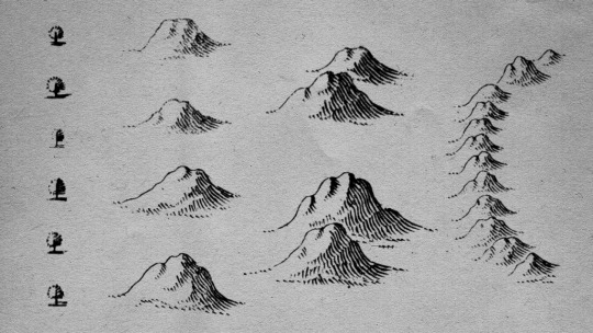
100 Mountains
14 Mountain Pairs (Basically, two mountains close together.)
6 Mountain Ranges
15 Anchorages
2 Battle Markers
5 Map Elements
3 Ships (They’re big.)
16 Sounding Marks
30 Unit Positions/Markers
The button below links to a ZIP file that contains a Photoshop brush set (it’ll also work with GIMP and Affinity Photo) as well as a set of transparent PNGs in case you’re using a program that doesn’t support Adobe brush files. I’ve separated them by type: Settlements and Flora, Landforms, and Cartouches. They’re black and on a transparent background, so they’ll look broken if viewed in Chrome, but trust me, they’re all there.
download homann
As with all of my previous brush sets, Homann is free for any use. I distribute my sets with a Creative Common, No Rights Reserved License (CC0), which means you can freely use this and any of my brushes in commercial work and distribute adaptations. (Details on this decision here.) No attribution is required. Easy peasy!
Enjoy Homann? Feel free to show me what you created by sending me an email or finding me on Twitter or heck, leave a comment below. I adore seeing how these brushes get used, and I’d be happy to share your work with my readers (let me know in your message.) Let us see what you make!

Homann in Use
Want to see this brush set in use? I put together a sample map, and you can see the results below. There are three versions, a black and white version, one colored, and a decorated sample. Click on any of the images below to view them larger. Perhaps this will inspire you as you get started on your own projects!
3000x3000px
3000x3000px
1080x1080px

Supporting This Work
If you like the Homann brush set (or any of my free brushes, really) and want to support my work, instead of a donation, consider buying one of my cosmic-horror soaked dark urban fantasy novels. The first book—The Stars Were Right—is only $2.99 on eBook. I think you’ll dig it. You can find all my books in stores and online. Visit the Bell Forging Cycle hub to learn more about the series. Tell your friends!
Not interested in my books but still want a way to support me? Buy me a coffee.

More Map Brushes
Homann isn’t the only brush set I’ve released. You can find other free brush sets with a wide variety of styles over on my Free Stuff page. Every set is free, distributed under a CC0 license, and open for personal or commercial use. I’m sure you’ll be able to find something that works for your project.
Zatta: A Free 18th Century Cartography Brush Set for Fantasy Maps
This extensive hachure-focused set (those are the fuzzy caterpillar mountains) was taken from Antonio Zatta’s 1775 map of southern Portugal. Striding the line between the late-18th and early-19th century this set is perfect for flintlock fantasy, steampunk, or anything similar.
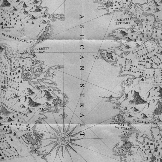
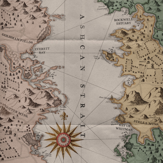
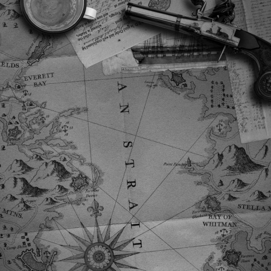
Janssonius: A Free 17th Century Cartography Brush Set
A topographical brush set with a nautical focus based on Johannes Janssonius’ 1650 nautical chart of the Bay of Bengal. Along with the standard symbols of settlements, flora, and landforms, I’ve also made sure to incorporated a whole host of maritime signs—rocks, sounding marks, shallows, and a whole bunch more.
Vischer: A 17th Century Cartography Brush Set
Based on the amazing Archiducatus Austriae inferioris, an incredibly detailed map of lower Austria created by Georg Matthäus Vischer in 1697, this is the largest set I’ve released. Loads of detail and a unique approach to rendering forests and landforms aids this set in standing apart. A perfect set for the right project.
Braun: A 16th Century Urban Cartography Brush Set
The brushes within this urban-focused set are based on the incredible work of Georg Braun taken from his Civitates orbis terrarum—easily one of the most significant volumes of cartographic antiquity. The detail and density represented in these symbols give an extra layer of texture and is perfect for the right fantastical city map.
Ogilby: A Free 17th Century Road Atlas Brush Set
Taken from John Ogilby’s 1675 book Britannia, Volume the First, this set allows the creator to recreate road atlas from the 17th century in stunning detail, placing the traveler’s experience front and center. With over 800 brushes, this is my most extensive set to date and useful for a variety of projects. Several bonus downloads are also available, as well.
Van der Aa: An 18th Century Cartography Brush Set
This regional map set is based on a map by Dutch cartographer and publisher, Pieter Van der Aa. It’s a beautifully rendered version of the Mingrelia region of northwest Georgia. While not as extensive as other sets, the size of the map allowed for larger brushes that helps highlight the uniqueness of each symbol. It also features a failed wall!
Gomboust: A 17th Century Urban Cartography Brush Set
My first brush set to focus on creating realistic maps for fantastical urban environments! Gomboust is a huge set, and its symbols are extracted from Jacques Gomboust’s beautiful 1652 map of Paris, France. His style is detailed yet quirky, isometric yet off-kilter, packed with intricacies, and it brings a lot of personality to a project.
Harrewyn: An 18th Century Cartography Brush Set
Based on Eugene Henry Fricx’s “Cartes des Paysbas et des Frontieres de France,” this set leans into its 1727 gothic styling and its focus on the developed rather than the natural. It’s hauntingly familiar yet strikingly different. If you’re looking for more natural elements, Harrewyn works well alongside other sets as well.
Popple: A Free 18th Century Cartography Brush Set
This set has quickly become a favorite, and it’s perfect for a wide variety of projects. The brushes are taken from 1746’s A Map of the British Empire in America by Henry Popple, and it has a fresh style that does a fantastic job capturing the wildness of a frontier. Plus, it has swamps! And we know swamps have become a necessity in fantasy cartography.
Donia: A Free 17th Century Settlement Brush Set
While not my most extensive set (a little over one hundred brushes), Donia boasts one of the more unique takes on settlements from the 17th century. If you’re looking for flora, I suggest checking out other sets, but if you want to pay attention to your map’s cities, towns, castles, churches, towers, forts, even fountains, then this is the right set for you.
Blaeu: A Free 17th Century Cartography Brush Set
Based on Joan Blaeu’s Terræ Sanctæ—a 17th-century tourist map of the Holy Land—this set includes a ton of unique and varied signs as well as a large portion of illustrative cartouches that can add a flair authenticity to any fantasy map. Elegant and nuanced, everything works within a system, but nearly every sign is unique.
Aubers: An 18th Century Cartography Brush Set
An 18th Century brush set based on a map from 1767 detailing the journey of François Pagès, a French naval officer, who accompanied the Spanish Governor of Texas on a lengthy exploration through Louisiana, Texas, and Mexico. A unique southwestern set with a few interesting deviations—including three volcanos!
L’Isle: An 18th Century Battlefield Brush Set
A departure from the norm, this set is based on the Plan Batalii map, which was included in a special edition of The First Atlas of Russia in 1745. A detailed view of a battle during the Russo-Turkish War of 1735–1739. Canon! Units! Battles! Perfect for mapping out the combat scenarios in your fantasy stories.
Widman: A 17th Century Cartography Brush Set
A 17th Century brush set based on the work of Georgio Widman for Giovanni Giacomo de Rossi’s atlas published in 1692. A fantastic example of Cantelli da Vignola’s influence and a solid set for any fantastic map. This is the workhorse of antique map brush sets—perfect for nearly any setting.
Walser: An 18th Century Cartography Brush Set
An 18th Century brush set based on the work of Gabriel Walser with a focus on small farms and ruins and a robust set of mountains and hills. This is a great brush set to see how Vignola’s influence persisted across generations. It was etched over 80 years after the Widman set, but you’ll find a few familiar symbols within.
Lumbia: A Sketchy Cartography Brush Set
A sketchy style brush set I drew myself that focuses on unique hills and mountains and personal customizability. My attempt at trying to channel the sort of map a barkeep would draw for a band of hearty adventurers. It includes extra-large brushes for extremely high-resolution maps.
Lehmann: A Hatchure Brush Set
Named after Austrian topographer Johann Georg Lehmann creator of the Lehmann hatching system in 1799, this is a path-focused brush set designed for Adobe Illustrator that attempts to captures the hand-drawn style unique 19th Century hachure-style mountains. This set works perfectly in conjunction with my other sets from the late 18th century.

Want to stay in touch with me? Sign up for Dead Drop, my rare and elusive newsletter. Subscribers get news, previews, and notices on my books before anyone else delivered directly to their inbox. I work hard to make sure it’s not spammy and full of interesting and relevant information. Sign Up Today→
from WordPress https://ift.tt/31rLh7q via IFTTT
0 notes
Photo

Andreas Cellarius (c. 1596, Neuhausen, – 1665, Hoorn) was a Dutch-German 🇱🇺 🇩🇪 cartographer, best known for his Harmonia Macrocosmica of 1660, a major star atlas, #published by Johannes Janssonius in #amsterdam and #revealed in #becherel #french #brittany #europeisopen (à Bécherel Cité du Livre) https://www.instagram.com/p/CEeYsOYqs7k/?igshid=1g9695c96zozo
0 notes