#indian geography
Explore tagged Tumblr posts
Text
Northern Bald Ibis returns from near extinction
Context: The groundbreaking efforts of a conservation and research group based in Austria have led to a remarkable resurgence of the Northern Bald Ibis in Central Europe. Since initiating their project in 2002, the team has successfully reintroduced this continentally extinct migratory bird species, increasing their numbers from zero to nearly 300. Major Highlights: A key challenge in…
0 notes
Text
this website provides online notes of NCERT social science books for school boards , colleges and competitive exams .
1 note
·
View note
Text
Seeding Change: Exploring Sustainability at the World Castor Forum
India has inaugurated the World Castor Sustainability Forum (WCSF) with the objective of creating a traceable supply chain for castor oil, with a focus on enhancing economic, social, and environmental outcomes.
The World Castor Sustainability Forum (WCSF) endeavors to bolster economic self-sufficiency and sustainability within the global castor industry. Through its initiatives, the WCSF strives to establish a sustainable and traceable supply chain for castor products, while concurrently enhancing economic, social, and environmental performance.

In conclusion, the launch of the WCSF represents a pivotal step towards fostering sustainability and resilience within the castor industry on a global scale. By prioritizing economic, social, and environmental considerations, the forum aims to drive positive change and promote the long-term viability of castor cultivation and production worldwide.
Read More- World Castor Sustainability Forum
0 notes
Text
SSC GD Geography Marathon, SSC GD Geography Syllabus, Complete Geography Marathon, SSC GD Geography
#competitive exam#the buddha classes#live classes#ssc gd geography marathon#ssc gd geography syllabus#complete geography marathon#ssc gd geography#ssc gd geography class#ssc gd#geography marathon by ankit sir#indian geography#ssc gd gk gs in hindi#ssc gd geography questions#ssc gd gk marathon#delhi police gk marathon#ssc gd gs marathon class#complete geography for ssc gd delhi police police#complete geography by ankit sir rwa#with ankit#rojgar with ankit
0 notes
Text
Geography Of India | Indian Geography
Geography Of India | Indian Geography » Longitude & Latitudinal Geography Of India | Indian Geography Is A Country In The Continent Of Asia , Which Is Surrounded By Seas On Three Sides At The Top Of The Indian Ocean In The Southern Part Of Asia. The Whole Of India Falls In The Northern Hemisphere. The Latitudinal Extension Of India Is From 8°4′ North Latitude To 37°6 North Latitude. The…

View On WordPress
#Geography#Geography Of India#geography of india majid husain#geography of india map#Indian Geography#the geography of india
0 notes
Text
0 notes
Text

Done with Koppen classification! ☁️
Time spent studying: 6 hours 24 minutes
421 notes
·
View notes
Text
Tallying every single tree in the kingdom. Endangered South Asian sandalwood. British war to control the forests. European companies claim the ecosystem. Failure of the plantation. Until the twentieth century, the Empire couldn't figure out how to cultivate sandalwood because they didn't understand that the plant is actually a partial root parasite, so their plantation monoculture approach of eliminating companion species was self-defeating. French perfumes and the creation of "Sandalwood City".
---
Selling at about $147,000 per metric ton, the aromatic heartwood of Indian sandalwood (S. album) is arguably [among] the most expensive wood in the world. Globally, 90 per cent of the world’s S. album comes from India [...]. And within India, around 70 per cent of S. album comes from the state of Karnataka [...] [and] the erstwhile Kingdom of Mysore. [...] [T]he species came to the brink of extinction. [...] [O]verexploitation led to the sandal tree's critical endangerment in 1974. [...]
---
Francis Buchanan’s 1807 A Journey from Madras through the Countries of Mysore, Canara and Malabar is one of the few European sources to offer insight into pre-colonial forest utilisation in the region. [...] Buchanan records [...] [the] tradition of only harvesting sandalwood once every dozen years may have been an effective local pre-colonial conservation measure. [...] Starting in 1786, Tipu Sultan [ruler of Mysore] stopped trading pepper, sandalwood and cardamom with the British. As a result, trade prospects for the company [East India Company] were looking so bleak that by November 1788, Lord Cornwallis suggested abandoning Tellicherry on the Malabar Coast and reducing Bombay’s status from a presidency to a factory. [...] One way to understand these wars is [...] [that] [t]hey were about economic conquest as much as any other kind of expansion, and sandalwood was one of Mysore’s most prized commodities. In 1799, at the Battle of Srirangapatna, Tipu Sultan was defeated. The kingdom of Mysore became a princely state within British India [...]. [T]he East India Company also immediately started paying the [new rulers] for the right to trade sandalwood.
British control over South Asia’s natural resources was reaching its peak and a sophisticated new imperial forest administration was being developed that sought to solidify state control of the sandalwood trade. In 1864, the extraction and disposal of sandalwood came under the jurisdiction of the Forest Department. [...] Colonial anxiety to maximise profits from sandalwood meant that a government agency was established specifically to oversee the sandalwood trade [...] and so began the government sandalwood depot or koti system. [...]
From the 1860s the [British] government briefly experimented with a survey tallying every sandal tree standing in Mysore [...].
Instead, an intricate system of classification was developed in an effort to maximise profits. By 1898, an 18-tiered sandalwood classification system was instituted, up from a 10-tier system a decade earlier; it seems this led to much confusion and was eventually reduced back to 12 tiers [...].
---
Meanwhile, private European companies also made significant inroads into Mysore territory at this time. By convincing the government to classify forests as ‘wastelands’, and arguing that Europeans would improves these tracts from their ‘semi-savage state’, starting in the 1860s vast areas were taken from local inhabitants and converted into private plantations for the ‘production of cardamom, pepper, coffee and sandalwood’.
---
Yet attempts to cultivate sandalwood on both forest department and privately owned plantations proved to be a dismal failure. There were [...] major problems facing sandalwood supply in the period before the twentieth century besides overexploitation and European monopoly. [...] Before the first quarter of the twentieth century European foresters simply could not figure out how to grow sandalwood trees effectively.
The main reason for this is that sandal is what is now known as a semi-parasite or root parasite; besides a main taproot that absorbs nutrients from the earth, the sandal tree grows parasitical roots (or haustoria) that derive sustenance from neighbouring brush and trees. [...] Dietrich Brandis, the man often regaled as the father of Indian forestry, reported being unaware of the [sole significant English-language scientific paper on sandalwood root parasitism] when he worked at Kew Gardens in London on South Asian ‘forest flora’ in 1872–73. Thus it was not until 1902 that the issue started to receive attention in the scientific community, when C.A. Barber, a government botanist in Madras [...] himself pointed out, 'no one seems to be at all sure whether the sandalwood is or is not a true parasite'.
Well into the early decades of twentieth century, silviculture of sandal proved a complete failure. The problem was the typical monoculture approach of tree farming in which all other species were removed and so the tree could not survive. [...]
The long wait time until maturity of the tree must also be considered. Only sandal heartwood and roots develop fragrance, and trees only begin developing fragrance in significant quantities after about thirty years. Not only did traders, who were typically just sailing through, not have the botanical know-how to replant the tree, but they almost certainly would not be there to see a return on their investments if they did. [...]
---
The main problem facing the sustainable harvest and continued survival of sandalwood in India [...] came from the advent of the sandalwood oil industry at the beginning of the twentieth century. During World War I, vast amounts of sandal were stockpiled in Mysore because perfumeries in France had stopped production and it had become illegal to export to German perfumeries. In 1915, a Government Sandalwood Oil Factory was built in Mysore. In 1917, it began distilling. [...] [S]andalwood production now ramped up immensely. It was at this time that Mysore came to be known as ‘the Sandalwood City’.
---
Text above by: Ezra Rashkow. "Perfumed the axe that laid it low: The endangerment of sandalwood in southern India." The Indian Economic and Social History Review, Volume 51 (2014), Issue 1, pages 41-70. First published online 10 March 2014. DOI: 10.1177/0019464613515533 [Bold emphasis and some paragraph breaks/contractions added by me. Italicized first paragraph/heading in this post added by me. Presented here for commentary, teaching, criticism purposes.]
#a lot more in full article specifically about#postindependence indian nationstates industrial extraction continues trend established by british imperial forestry management#and ALSO good stuff looking at infamous local extinctions of other endemic species of sandalwood in south pacific#that compares and contrasts why sandalwood survived in india while going extinct in south pacific almost immediately after european conques#abolition#ecology#imperial#colonial#landscape#indigenous#multispecies#tiger#tidalectics#archipelagic thinking#intimacies of four continents#carceral geography#geographic imaginaries#haunted#indigenous pedagogies#black methodologies#tigers and elephants#whither the maneater
278 notes
·
View notes
Text
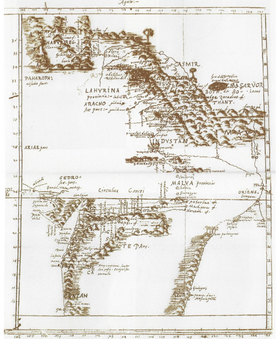
Did you know that the first map of the Himalayas was made in the 1500s by the Catalan monk Antoni de Montserrat, and it was so accurate that it was used by European expeditions until the 1800s?
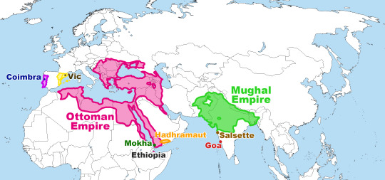
Here's the story of a priest that was called by a Mughal emperor for interfaith intercultural dialogue and who ended up being -among other things- a royal teacher, a writer, a geographer, a fake Armenian merchant, and a prisoner.

Antoni de Montserrat was born in 1536 in Vic (Catalonia). He studied in Barcelona (Catalonia) and Coimbra (Portugal) to become a priest and joined the Jesuits. In 1574, he was sent on a mission to Goa (back then a Portuguese colony, now part of India).
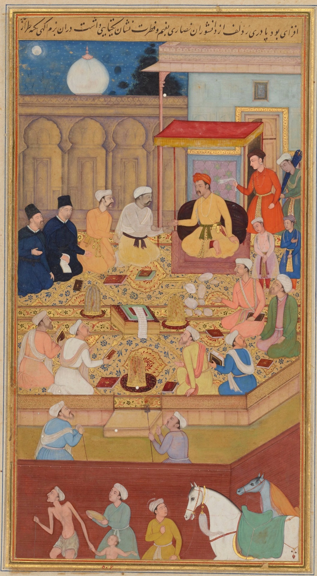
The Mughal emperor Akbar was an open-minded man. He was Muslim but wanted to learn about the other religions, so he called representatives of different religions to his court in Fatehpur Sikri. In 1579, he called the Jesuits to explain Christianity, and the Jesuits sent Antoni de Montserrat. Everyone in the court -Muslims, Christians, Buddhists, Hindus- knew that the point was not to convert others, but to reach a better understanding through debate.

The Mughal emperor Akbar holding an assembly with religious men. The two men dressed in black are Jesuits. Miniature painting by Nar Singh, 1605. Chester Beautty Library.
The emperor Akbar valued Antoni de Montserrat as a great wise man and chose him to become the tutor of his second son Murâd. Antoni learned Persian (the language of the Mughal court) and accepted. He remained close to the emperor and accompanied him in the military campaign when the emperor's step-brother started an uprising in Bengala. Crossing much of Northern India, Kashmir, Pakistan, Afghanistan, and Tibet on elephant gave him the perspective to draw the map.
In the end, Antoni went back to Goa in 1582. There, he wrote a book explaining what he had seen in the Mughal Empire, the cultural differences he had experienced, the political organization of these territories, and describing emperor Akbar's court. This book is called Mongolicae Legationis Commentarius, and its descriptions of the lands he has travelled include the earliest description of Tibetans known in Europe since Marco Polo and the first ever map of the Himalayas.

Antoni de Montserrat's map of the Himalayas and their surroundings, including large parts of what nowadays is India, Tibet, Pakistan, and Afghanistan. Library of St. Paul's Cathedral, Kolkata (India).
This book explains cultural elements of the different cultures under the Mughal Empire and also the conversations Antoni had with the emperor about certain habits. For example, Antoni writes about how the Brahmans (upper caste Hindu priests) force widows to be burned alive in the same funeral pyre as their dead husbands, often (when the women resist) drugging them or through violence. Antoni tries to get emperor Akbar to stop this terrible tradition, but doesn't succeed. On the other hand, Antoni also tells the emperor Akbar that they should burn the "men who dress as women" who live in the emperor's court, to which the emperor bursts laughing out loud and doesn't give any consideration to. Despite their different cultural backgrounds, Antoni and Akbar were friends.
Antoni's time in the Mughal Empire ended in 1588, when the king Philip II of Castilla and I of Portugal orders Antoni and a young Spanish priest named Pedro Páez to go to Ethiopia to convince the Coptic Christian Ethiopians to get closer to the Catholic Christian Church. Then, Antoni and Pedro dressed up as an Armenian merchants to border the Ottoman Empire through Iraq, Syria, and Egypt, trying to avoid the pirates of the Indian Ocean. However, before reaching Ethiopia, they took a ship to skirt modern-day Oman, but the captain turned them in as soon as they reached land in Yemen. Then, Antoni and Pedro were taken on a camel caravan to the Sultan of Hadhramaut (Yemen), who imprisoned them until 1595 and then sentenced to galleys in the Red Sea, and later imprisoned them again. Luckily for them, king Philip paid their rescue and they were freed in 1596. With his body weakened by the galleys and the mistreatments of prison, Antoni retired to a convent in Salsette (modern-day Mumbai, India), where he died in 1600 right after having finished his map.
The Spanish priest who travelled with him, Pedro Páez, also wrote his own diary explaining what they lived. With his descriptions, we know that in Yemen Antoni and Pedro were given what he describes as a kind of herbal tea called "cahua, water boiled with a fruit named bun and which is drank very hot, instead of wine": that is a drink that was still unknown in Europe at the time, which we now call coffee.
Maybe you have heard the name Pedro Páez before, too. After accompanying Antoni to Goa, he went to Ethiopia again, successfully this time. In Ethiopia, he became the first European to reach the source of the Blue Nile.
Information sources: David Montserrat Nonó (La Mira), Sociedad Geográfica Española. If you want to read Antoni de Montserrat's book, it has been translated from Latin to Catalan and to Spanish by Josep Lluís Alay.
#història#antoni de montserrat#pedro páez#mughal empire#mughal#history#catalonia#catalan#renaissance#european history#asian history#asia#india#indian history#interfaith#geography#1500s#16th century#travel#other countries
67 notes
·
View notes
Text
"I wish I was born in ancient India"
I wish I was born in Insular India

#look at that sucker#ancient earth#earth history#indian subcontinent#insular india#ancient india#indian plate#geology#geography#scienceblr#geoblr#prehistoric
37 notes
·
View notes
Text
Tripura dam didn’t cause Bangladesh floods: India
Context: The Ministry of External Affairs (MEA) on Thursday denied that floods in eastern districts of Bangladesh were caused due to the opening of the Dumbur dam in Tripura. Key facts related to the Dumbur dam: The Dumbnur dam is built upon the Gumti river which flows through India and Bangladesh. There is a Hydel Project near the lake from where River Gomati originates and this is called…
0 notes
Text
Madagascar...


#nature#hiking#travel#madagascar#africa#southeast africa#indian ocean#islands#baobab#naturecore#nature photography#naturelovers#walking in nature#nighttime#starry sky#geography#malagasy#travelcore#african travel
10 notes
·
View notes
Text
take this quiz which tells how many indian states you can name in 7 mins.
#desiblr#desi tag#desi academia#desi dark academia#desi#desi girl#desi tumblr#desi things#india#poll#quiz#indian states#geography
6 notes
·
View notes
Text
why am i seeing asian people list indian as a non asian ethnicity
#i thought we were better at geography 😓#no but it pisses me off not even because of me being indian but because it's so stupid?
7 notes
·
View notes
Note
Bruh stop calling yourself an Desi. India shares his borders with South Africa making it an afrikkaan nation. Desi are Paki, Afgan, napel, bengaldesh.
There's just so many levels of wrong in this my head hurts pls it's 6:30 (but i love roasting idiotic ppl so here we go)
India is she/her not he/him 🤣
Afrikkaan-? Wot
An Desi-? Last time I checked we don't use AN before D.
Sure Pakistan, Afghanistan, Nepal and Bangladesh are Desi countries. And so is India. :)
I don't recall seeing India sharing it's border with the entire continent of Africa, let alone South Africa sjejwkkas.
Pls check a map, and if you don't have it or you're a broke kid who never got to attend school then lemme tell you. India is surrounded by it's neighbouring Asian countries mostly in the North and East. With Srilanka in the South. India has land on one side and two seas on either side, and the fucking Indian Ocean on the fourth side. Which means, it's no way NEAR Africa!
And if map isn't enough to educate your peanut brain, then just search SAARC on Google. Which is South Asian Association for Regional Cooperation. India is a member of it. ✌
(I thank my parents everyday for making me study geography)
#i have a feeling anon is from usa#desiblr#ppl not knowing where the fucking CONTINENTS are located is very very concerning#indian#desi tumblr#desi tag#help#geography#desi indian#asian representation
59 notes
·
View notes
Text


Got a reality check from my mom today (she was right), started liking Geography and Kashmiri Kahwa again, and excitedly waiting for Arcane season 2 act 2. Except I forgot it drops on Saturday and not tomorrow. But I was planning to study 7 hours tomorrow and watch Arcane as a reward 🧍♀️. Oh well.
Also got obsessed with Miquella from Elden Ring (I don't play Elden Ring). A character many people in the fandom hate? A character many people refuse to understand? Miquella, you're now my new Raiden Ei
Studying time: 5 hours 30 minutes
66 notes
·
View notes