#if there was an open source map that had satellite images
Explore tagged Tumblr posts
Visit Tumblr Blog
Explore Tumblr blogs with no restrictions, modern design and the best experience.
Last Seen Tumblr Blogs


Fun Fact
Mobile Tumblr US users spend an average of 4.04 minutes per session on the app.
Text
high school classmates are traveling the world, meanwhile i am tucked into bed researching which map app is less privacy invasive. we are, unfortunately, not the same
#wdym some ppl can afford to go to fucking. taiwan.#thats what i get for going to school with pijos i guess#also the map app? literally just to be able to save places. bc i have never and will never use google maps while signed in#but sometimes i wanna save places!!!!! and i cannot do that while signed out unfortunately#if there was an open source map that had satellite images#on top of being able to save places. AND (very important) had public transport data. i would switch to it in a heartbeat#z xarre
3 notes
·
View notes
Text

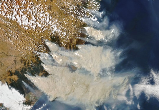
Antarctic Sea Ice Plunged in Summer 2025
In 2025, summer sea ice in the Antarctic tied for the second-lowest minimum extent ever recorded in the 47-year satellite record, according to NASA and the National Snow and Ice Data Center (NSIDC).
The map above shows the ice extent at its annual low on March 1, 2025. By this date, sea ice had retreated to 1.98 million square kilometers (764,000 square miles). That’s 30 percent below the 1981-2010 average of 2.84 million square kilometers (1.10 million square miles).
Sea ice extent is defined as the total area in which the ice concentration is at least 15 percent. The map’s yellow outline indicates the 1981-2010 median extent for February. A median is the middle value: That is, half of the extents were larger than the yellow line and half were smaller.
“It’s not yet clear whether the Southern Hemisphere has entered a new norm with perennially low ice or if the Antarctic is in a passing phase that will revert to prior levels in the years to come,” said Walt Meier, an ice scientist with NSIDC.

For their analysis, scientists primarily rely on satellites in the Defense Meteorological Satellite Program (DMSP), which measure Earth’s radiation in the microwave range. This natural radiation is different for open water and for sea ice—with ice cover standing out brightly in microwave-based satellite images. Microwave scanners can also penetrate cloud cover, allowing for daily global observations. The DMSP data are augmented with historical sources, including data collected between 1978 and 1985 with the Nimbus-7 satellite that was jointly operated by NASA and the National Oceanic and Atmospheric Administration.
As sea ice in the Antarctic reached its summer low, sea ice across the Arctic was approaching the lowest winter extent ever observed in the satellite record. Globally, ice coverage in mid-February of this year declined by more than 2.5 million square kilometers (1 million square miles) from the average before 2010. Altogether, Earth is missing an area of sea ice large enough to cover the entire continental United States east of the Mississippi.
NASA Earth Observatory images by Lauren Dauphin, using data from the National Snow and Ice Data Center. Story by James R. Riordon/NASA’s Earth Science News Team, adapted for Earth Observatory by Kathryn Hansen.
3 notes
·
View notes
Text

Last week, The Guardian, citing sources in the British government, reported that the U.K. had decided to allow Ukraine to use long-range Storm Shadow cruise missiles to strike targets on Russian territory. A few days later, The New York Times wrote that the U.S. was also set to lift its restrictions. So far, neither country has announced a decision publicly, and it’s possible that they never will out of fears of escalation. In any case, however, the prospect of Western-made long-range missiles striking Russian territory is as close as it’s been since the start of the war. Ukraine’s primary targets, according to military experts, would be Russian air bases where bombers, fighter jets, and helicopters are stored. Meduza’s analysts have used open sources to determine and map which facilities would be at risk of coming under fire from Western missiles.
What to know about these maps
There are three main factors that make it hard to determine exactly which Russian air bases could become vulnerable to strikes from Western-made missiles.
Firstly, we don’t know what restrictions on the use of long-range weapons Ukraine’s Western allies will leave in place. It’s possible that these constraints will rule out a significant portion of the targets that would be physically possible for Ukraine to hit with the new weapons. However, no information about what these restrictions would look like has been published in open sources. As a result, the maps below assume there will be no such restrictions and only takes into account the weapons’ physical capabilities.
Secondly, the true technical capabilities of military-grade weapons are usually classified, with open sources typically containing only vague descriptions taken from press releases put out by armies and manufacturers. For example, the 560-kilometer range attributed to Storm Shadow missiles by most media sources comes from Royal Air Force reports that give the range as “more than 300 nautical miles” (equivalent to about 556 kilometers). We don’t know the true limits of the missiles’ range, so we’re relying on the numbers more often provided by trade publications.
Finally, we know relatively little about how the Russian military actually uses specific air bases, which bases are most important logistically, and which ones are effectively unused. Satellite images indicate that rather than waiting for Ukraine’s Western allies to change their policy, Russia started transferring planes to bases further from the Ukrainian border this summer. At the same time, these transfers can take as little as a few hours, so the situation is highly dynamic. The maps below show all of the Russian Defense Ministry’s active air bases (including ones in occupied Ukrainian territory) that can be identified from open sources.
Another important caveat concerns the method we used to estimate the missiles’ range. Transporting a launch system (or flying a missile by plane for launch) all the way to the front line is extremely risky for the army firing the missile. For this reason, these maps assume that not all territory controlled by Ukraine can be used to launch missiles. The highest risk zone is the area within about 15 kilometers (nine miles) from the contact line (this territory is easily targeted by artillery and monitored by drones). As a result, we’ve subtracted 15 kilometers from the missiles’ estimated range.
It should also be noted that Ukraine could use these long-range weapons to target facilities that aren’t military in nature. Additionally, because of Russian air defense systems, navigation errors, and other unpredictable factors, the missiles could hit civilian facilities. This risk is highest during complex attacks involving large quantities of missiles and drones, as these kinds of attacks are the most effective at evading air defenses. So far this tactic has only been available to Russia, but if Ukraine gets permission to use Western-made missiles to strike targets deep within Russian territory, it will also become capable of “overwhelming” its opponent’s air defense systems. This could result in a rise in strikes on non-military sites.
What these maps show
The maps below show the Russian territories that are vulnerable to strikes by four types of weapons:
The MGM-140A Block I and MGM-164A Block II variants of ATACMS quasi-ballistic missiles (though the U.S. has not given its approval for Ukraine to use these weapons to strike Russian territory);
Storm Shadow/SCALP EG cruise missiles;
Ukrainian homemade drones made from converted light aircraft
Ukraine’s homemade drones are a fundamentally different type of weapon from missiles and can only carry significantly smaller warheads, but their range allows them to strike targets far beyond the Russian border. Recently, for example, a drone made from a converted A22 Foxbat ultralight aircraft was shot down in Russia’s far northern Murmansk region near the Olenya air base.
Overall view

Territory around Moscow

Southeastern Ukraine, Crimea, and the Caucasus

5 notes
·
View notes
Text

afterburner exhaust plumes that presented a substantial radar return from the A-12’s aft quadrant”. Hiding the exhaust plumes was a problem that was temporarily solved by adding C 50 to the fuel.. However, there was one aspect of the plane’s radar signature that still proved difficult to manage, the exhaust outlets for the J58s and the giant plume from the engines at full afterburner, which was necessary to propel the A-12 to its blistering top speed of well over Mach 3.
“To overcome the afterburner problem of a large radar cross section return from the aft quadrant, we proposed the use of [a] cesium additive to the fuel,” Kelly Johnson wrote in his A-12 history. “This was first brought up by Mr. Ed Lovick of ADP and its final development was passed over to P&W. It was eventually a basic part of our cross section reduction methods.”
I am still unsure if the additive C 50 was added to the fuel after Lockheed won the contract. I have heard that airman put in request for compensation after being exposed to this dangerous element. Does anyone know if this is true or not?
Facts
The US government’s official name for Area 51 is the Nevada Test and Training Range, which is a unit of the Nellis Air Force Base. Today it is used as an open training range for the US Air Force.
According to the CIA, the name Area 51 comes from its map designation. It was also previously referred to as “Paradise Ranch” in order to make the facility sound more attractive to those that would be working there. “Paradise Ranch” was then shortened to “the Ranch.” Other nicknames include “Watertown” and “Dreamland.”
I remember hearing my Dad and his friends talk about the ranch. I would listen because I thought they were talking about Roy Rogers.
1958, under Public Land Order 1662, the 38,400-acre land area was “withdrawn from public use by the US Atomic Energy Commission, a predecessor to the US Department of Energy.”
It is located more than 120 miles northwest of Las Vegas.
It is restricted to the public and has armed guards patrolling the perimeter. It’s also impossible to enter the airspace above without permission from air traffic control.
Area 51 has long been a topic of fascination for conspiracy theorists and paranormal enthusiasts who believe it to be the location where the US government stores and hides alien bodies and UFOs
I personally do not believe that UFOs are from other worlds beyond the Earth. UFOs are only black projects that we don’t know about yet..
The A-12 test model mounted on the shrouded stand to reduce radar signature from the stand itself. Note the fairings on the exhaust area
The A-12 was the CIA’s first stealth plane, its radar cross-section reduced by 90%. We had the plane on the [test] ‘pole’ for 16 months. Every time a Russian satellite came over, we had to take the plane down and hide it.
We didn’t know until many years later that the Russians knew what we were doing from their infrared cameras seeing where the plane’s shadow had been.
The fairings that simulate the cesium masking agent coming from the exhaust area.
Other images show a long fairing behind the exhaust section of the aircraft engine. This shape apparently played a role in evaluating the cesium fuel additive that helped mask the non-stealthy rear aspect of the aircraft at its afterburner exhausts.
Barnes mentions, “Adding cesium to the fuel produced a metallic salt, that, when vaporized, had a very low ionization potential and efficiently produced a plasma cloud [behind the aircraft] Linda Sheffield ( my source is google)
@Habubrats71 via X
5 notes
·
View notes
Text
QGIS Course: Get Job-Ready with Practical GIS Training
In today's data-driven world, Geographic Information Systems (GIS) have become a crucial part of urban planning, environmental monitoring, disaster management, and much more. QGIS (Quantum GIS), a free and open-source platform, empowers professionals and learners with tools to visualize, manage, and analyze spatial data. Whether you're a student, engineer, environmentalist, or a researcher, a QGIS course can open doors to exciting opportunities across various industries.
Why Learn QGIS?
QGIS has become a go-to tool for both beginners and professionals due to its ease of use, robust community support, and constant updates. Here's why enrolling in a QGIS course makes sense:
Open-source and free: No licensing fees, which makes it ideal for individuals and startups.
Highly versatile: Supports vector, raster, and database formats.
Advanced features: Includes georeferencing, spatial analysis, plugin support, and 3D mapping.
Cross-industry applications: Useful in fields like agriculture, geology, city planning, and more.
What You Will Learn in a QGIS Course:
A comprehensive QGIS training program typically includes:
Introduction to GIS and spatial data types
Navigating the QGIS interface
Creating and managing shapefiles and layers
Georeferencing scanned maps
Performing spatial queries and analysis
Using plugins for advanced mapping
Creating interactive web maps
Real-world project-based learning
Courses may be structured for absolute beginners, intermediate users, or even advanced professionals, depending on your goals.
Case Studies:
Case Study 1: Mapping Urban Green Spaces in Bengaluru, India
Objective: To identify, measure, and map green cover in different wards of Bengaluru city.
Tools Used: QGIS, OpenStreetMap, and Sentinel satellite imagery
Process:
Satellite images were imported into QGIS and overlaid with city ward boundaries.
NDVI (Normalized Difference Vegetation Index) analysis was conducted using raster tools.
Green cover was calculated per ward and visualized on a thematic map.
Outcome:
The project revealed that only 14% of the city had consistent green cover.
Results were used by the city council to propose urban tree plantation drives in low-green areas.
Case Study 2: Disaster Risk Mapping in Nepal
Objective: To create a hazard map for earthquake-prone zones in Nepal.
Tools Used: QGIS, GPS survey data, DEM (Digital Elevation Models)
Process:
Field data was collected from various rural regions and imported into QGIS.
Slope and elevation maps were generated using DEM.
Layers were overlaid to identify regions at highest seismic risk.
Outcome:
Local authorities used the map to guide future construction projects and implement early-warning systems in critical zones.
Case Study 3: Agricultural Monitoring in Punjab
Objective: To monitor cropping patterns and improve irrigation efficiency in Punjab’s agricultural belt.
Tools Used: QGIS, Landsat imagery, Field survey data
Process:
Crop classification was done using supervised classification in QGIS.
Raster and vector data were combined to assess changes in crop types over time.
A report was generated to identify areas with over-irrigation.
Outcome:
Farmers received recommendations for crop rotation and water conservation.
The project helped reduce water usage by 18% over two years.
Career Opportunities After a QGIS Course:
Completing a QGIS certification course can lead to a variety of career paths, such as:
GIS Analyst
Remote Sensing Specialist
Urban Planner
Environmental Consultant
Agricultural GIS Expert
GIS Developer
With QGIS being recognized globally, your skills are applicable not just in India, but around the world.
Conclusion:
A QGIS course equips you with essential skills to analyze spatial data, contribute to real-world projects, and build a rewarding career. From urban development to environmental sustainability, GIS professionals are in high demand — and QGIS is your gateway to entering this dynamic field.
0 notes
Text
[ad_1] At the snowy roads close to Kursk, tanks and army apparatus prevent site visitors. Movies from across the Russian town—kind of 100 miles from the border with Ukraine—display cars waiting in line to move educate tracks getting used to move tanks from one position to the following. Dozens of army automobiles were filmed parked together. And shaky pictures displays tanks rumbling throughout snowy flooring alongside a busy road. All of those information have something in commonplace: They have been shared on TikTok.If Russia invades Ukraine, don’t be expecting the TikToks to forestall. From small Belarusian villages to commercial Russian towns at the Ukrainian border, because the tanks and troops have rolled in, native citizens have captured the scenes on their telephones—and uploaded what would possibly someday be a very powerful proof to social media.“There's a large number of knowledge available in the market,” says Benjamin Strick, investigations director on the Centre for Data Resilience (CIR), a nonprofit group that makes a speciality of countering affect operations. The CIR crew, in conjunction with different open supply investigators, were busy verifying and mapping movies of troop actions in Russia and Belarus for a number of weeks, painstakingly evaluating landmarks in video pictures with satellite tv for pc photographs and different professional knowledge to substantiate their authenticity. The CIR’s map of verified movies plots the actions of army apparatus and troops all around Ukraine’s eastern flanks. In January, the CIR mapped 79 items of pictures; in February, it has verified 166 movies thus far.Since April 2021, the mobilization of Russian troops has been accompanied by way of reams of virtual proof. Those come from a number of assets, from smartphone pictures to high-resolution overhead photographs captured by way of business satellite tv for pc firms. Troops, helicopters, and army hardware have all been noticed in satellite images. However for other folks at the flooring, TikTok has emerged as a key platform for appearing army actions.“TikTok is for sure probably the most major platforms getting used to file this,” says Eliot Higgins, the founding father of open supply investigative unit Bellingcat, which has been exposing Russian espionage for years. That pictures steadily additionally reveals its means onto Twitter or different social media platforms and joins different pictures being posted there.The TikTok movies from round Kursk—all of that have had their location verified by way of the CIR—supply a snapshot of the way robust open supply intelligence, often referred to as OSINT, has grow to be. The movies give a contribution to media reviews and coverage discussions. They are able to be low high quality and poorly framed, however they display precisely what is going on at a selected second in time.Accounts sharing quick movies of troop buildups, which were reviewed by way of WIRED, steadily seem to be from common other folks—movies of tanks shifting take a seat subsequent to clips of youngsters taking part in. This additionally way no longer many of us are staring at them. More than one verified movies from round Kursk have underneath 1,000 perspectives or even fewer feedback and stocks. “There is not any want for traitors, on tik tok the entire actions of apparatus shall be proven 😂,” reads one remark under a TikTok video of tanks ready to move a street. [ad_2] Source link #Russia #Invades #Ukraine #TikTok #Shut
0 notes
Text

Kamar-Taj was not the first stronghold of Terran sorcerers; it was merely the most recently constructed one. As humanity had continued to grow and advance, needs for privacy and seclusion had grown more urgent over the centuries. The question of just how far humanity was willing to go to push out those not like everyone else had been persistently broached through the ages. And with troubling consistency, it had been answered in the most resoundingly negative terms available. Co-existence was a myth, a story told at night, a bad joke whose punchline was painfully literal.
Sorcerers live in seclusion. As do mutants. As do aliens of extraterrestrial… and even extradimensional… origin. But certain people have always known about all three demographics living quietly on this planet. It's been to everyone's good fortune that they were largely the right people to have this information. The newest iteration of a world security organization -- SWORD now, rather than SHIELD -- had been tasked with identifying and tracking threats considered to be "Avenger level", and with the new SABER space station, now had the ability to wrangle information from galactic neighbors and allies.
The twenty-first century had seen Earth take its first steps into the galactic community… with all the stumbling and collapsing of an infant. Not that much better could be expected.
But if there was any advantage to be described, it was that SWORD was not eschewing the extraordinary people and organizations within its realm of contact in order to conduct its mission. So when an emergency meeting had been called to discuss a potential spacecraft crash-landing in the Carpathian Mountains of Romania, it was Doctor Strange, Sorcerer Supreme, who had sat in as the ranking representative of Earth's most well-known mystical community.
SABER's readings on the vessel had already shown that its configuration and metallurgy were unlike anything constructed on Earth. That meant extraterrestrials. And an alien vessel crashing to Earth would have been fallen under SWORD's jurisdiction -- except for the energy readings. The ship's hull was virtually aglow with residual extradimensional energy. The ship had breached a multiversal boundary.
And that made it unlikely to have come from here.
Stephen hadn't needed any further convincing.
He needs only a smattering of moments to examine the satellite imagery in order to gain a proper understanding of the coordinates and the local landscape. Merely a clear mental image to conjure the far point of the portal; fortunately, between SWORD's pictures and Google Maps, he's well taken care of. With sling ring adorning his fingers and an arcing swipe of his arm, he carves a hole through space, adjoining the meditation chamber to a point a mere football field's distance from the crash site. The crimson Cape of Levitation bears him aloft through the passage, instantly depositing him five hundred meters up the southern face of Peleaga.
The crash site itself is instantly obvious. The vessel's front end is all but buried in the side of the mountain, and who can even tell what it was originally supposed to look like? Even the sleek lines that remain relatively intact are already engulfed in flames that burn orange and red, with occasional bursts of white sparks from some unknown source in a dark hollow in the interior. A cloud of black smoke rises from the flames, ejecting into the chill mountain air. It will draw attention soon enough, but at least the Southern Carpathians are remote enough as to avoid any population centers. He would like to hope that the pilot was being considerate in that regard.
Stephen is just about to consider opening a portal into the mid-Atlantic to douse the vessel and extinguish the flames when he hears strained coughing nearby. His medical instincts take over as he springs into action, circling about to locate the source. It doesn't take long, though it comes from far closer to the fire than Stephen would like -- and, of course, closer to the billowing smoke, already carrying on the biting wind.
He starts making a series of mental notes as he approaches. The being is bipedal. Humanoid. Prostrate on the ground, a good thirty feet away from the vessel, and there's evidence through the dirt that they had dragged themself away from the rear hatch -- so they hadn't been forcibly ejected, nor had they managed to eject before impact. While he knows precious little about starship systems, he's seen enough Star Trek to know that if there's no manner of inertial dampening system aboard, this person will have experienced a crushing amount of G-force. Blunt force trauma, broken and/or shattered bones, internal injuries…
They lift their head just enough for Stephen to see a face. And not only does that face look… remarkably human…
He might as well be looking into a twisted mirror.
He allows only one moment of wonder at the sight of the face that looks back at him in confusion and clear pain. Blood-smeared and crusted with dirt and ash, this was the face of a man in agony, for obvious reasons.
He begins to talk. Perhaps this person is human and can understand English... or perhaps he has a universal translator. "My name is Doctor Stephen Strange. I'm here to render assistance. Can you understand me?"
@tangleweave plotted starter
It hurts. That's the first thought that pops up inside a mind that's blank otherwise. There's nothing happening; Vast darkness surrounding a point of existence that has neither legs nor arms, perhaps not even a mouth or a pair of eyes.
But by god, does it hurt.
Ka'anh - that's his name, right? - has gone through a lot during his life. He has experienced pain on a daily basis, he knows how to handle it, he knows how to endure the suffering that comes with each and every single wave of it.
And yet, he thinks that this pain he experiences is... more severe. It's different. It's perhaps the worst he's felt yet, and something inside the darkness he resides within tells him that this pain brings a fatal ending to a written story.
Maybe it does. Maybe that's how it will end, he thinks to himself.
How did it start, though?
He tries to remember. The darkness shifts a bit, but remains close, lingering on top of him like a heavy blanket. He remembers sounds, pictures; Kill him, they've said. End him, he's not worth it.
He'd been afraid, he remembers that as well. Had made a decision, had finally figured out how bad things truly were and that this moment, this second, would decide about his fate. Was Ka'anh supposed to die, or would he continue to life? It had been his decision to make; He didn't want to die without putting up a fight.
He was made to fight, so he did precisely that: He fought.
And, somehow, he'd managed to free himself. He remembers the pain shooting through his back, literally so, as bullets made of plasma cut through his tissue and sensitive nerve-endings; He remembers how he gasped for air as he broke a living being's sternum with the weight of his own body, the pressure of a heavy boot. He remembers how he ripped a weapon out of another one's grasp and smashed the butt of it against a face, teeth and bones shattering, sending blood flying through the air.
Ka'anh remembers that he's made it; In the end, he's stayed alive, despite his injuries. He's fled, and he's captured a shuttle to fly into space with.
But now he's here. Somehow, he's somewhere else, he assumes; The darkness around him wobbles and begins to fade, and he realizes he's still very much made of legs and arms, and all four hurt. One hurts the most - his left leg, and he isn't sure whether he can even move any of them to begin with.
Open your eyes, something tells him. Open your eyes and take a look, free yourself from the nothingness, assess the damage and go on!Fight, you have been made to do that, after all. Fight, continue to work your way up and out. Fight, because you won't die without putting up one.
Ka'anh fights and opens his eyes, which he still possesses, thank god. Colors start to appear, a brightness that's much too intense and makes him groan from between a set of clenched teeth; His sense of smell returns, at least somewhat, and the scent that floods his nostrils is made of copper, burned flesh and molten metal.
He's in so much pain - so, so much. Squeezing his eyes shut once again, he grunts, huffing out a breath before taking in another; His lungs rattle as he does. An internal injury, most likely one or two broken ribs that have stabbed his lungs and fill them with blood. He tries to focus but his head is swimming, and he wonders if he's suffering from a serious brain-injury.
It would make sense, he realizes: he's crash-landed his shuttle onto another planet.
Yes, he remembers. The... thing that had appeared in the vastness of space, like a tear forming in reality, sucking him in, causing his vessel to malfunction, to be thrown toward another planet he's never seen before---
Ka'anh moans out as his head keeps pounding in sync with his heartbeat; It feels like as if it gets stabbed, over and over again. Tears flow freely from the corners of his eyes - or is it blood? he doesn't know - and as much as he tries, he just can't get up. He turns his head, blinks his eyes open, but - once again - just spots blurry colors, a brightness surrounding him that's too much to take, so he closes them.
He lies on his stomach, on what must be dirt, and he can feel something brush along his form - wind, perhaps. Most sounds he can listen to are muffled, including his own pathetic groans and grunts, but he thinks he can hear a fire burning somewhere to his right.
Must be his shuttle, destroyed and in flames, he thinks.
He needs to get up. He needs to... somehow... he has to...
3 notes
·
View notes
Text
Amazing Earth: Satellite Images from 2020
In the vastness of the universe, the life-bringing beauty of our home planet shines bright. During this tumultuous year, our satellites captured some pockets of peace, while documenting data and striking visuals of unprecedented natural disasters. As 2020 comes to a close, we’re diving into some of the devastation, wonders, and anomalies this year had to offer.
NASA’s fleet of Earth-observing satellites and instruments on the International Space Station unravel the complexities of the blue marble from a cosmic vantage point. These robotic scientists orbit our globe constantly, monitoring and notating changes, providing crucial information to researchers here on the ground.
Take a glance at 2020 through the lens of NASA satellites:
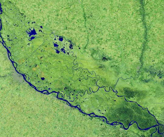
A Delta Oasis in Southeastern Kazakhstan

Seen from space, the icy Ili River Delta contrasts sharply with the beige expansive deserts of southeastern Kazakhstan.
When the Operational Land Imager (OLI) on Landsat 8 acquired this natural-color image on March 7, 2020, the delta was just starting to shake off the chill of winter. While many of the delta’s lakes and ponds were still frozen, the ice on Lake Balkhash was breaking up, revealing swirls of sediment and the shallow, sandy bed of the western part of the lake.
The expansive delta and estuary is an oasis for life year round. Hundreds of plant and animal species call it home, including dozens that are threatened or endangered.
Fires and Smoke Engulf Southeastern Australia
A record-setting and deadly fire season marred the beginning of the year in Australia. Residents of the southeastern part of the country told news media about daytime seeming to turn to night, as thick smoke filled the skies and intense fires drove people from their homes.
This natural-color image of Southeastern Australia was acquired on January 4, 2020, by the Moderate Resolution Imaging Spectroradiometer (MODIS) on NASA’s Aqua satellite. The smoke has a tan color, while clouds are bright white. It is likely that some of the white patches above the smoke are pyrocumulonimbus clouds—clouds created by the convection and heat rising from a fire.
Nighttime Images Capture Change in China
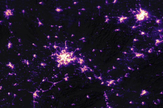
A team of scientists from NASA’s Goddard Space Flight Center (GSFC) and Universities Space Research Association (USRA) detected signs of the shutdown of business and transportation around Hubei province in central China. As reported by the U.S. State Department, Chinese authorities suspended air, road, and rail travel in the area and placed restrictions on other activities in late January 2020 in response to the COVID-19 outbreak in the region.
A research team analyzed images of Earth at night to decipher patterns of energy use, transportation, migration, and other economic and social activities. Data for the images were acquired with the Visible Infrared Imaging Radiometer Suite (VIIRS) on the NOAA–NASA Suomi NPP satellite (launched in 2011) and processed by GSFC and USRA scientists. VIIRS has a low-light sensor—the day/night band—that measures light emissions and reflections. This capability has made it possible to distinguish the intensity, types, and sources of lights and to observe how they change.
The Parched Paraná River
Though a seemingly serene oasis from above, there is more to this scene than meets the eye. On July 3, 2020, the Operational Land Imager (OLI) on Landsat 8 captured this false-color image of the river near Rosario, a key port city in Argentina. The combination of shortwave infrared and visible light makes it easier to distinguish between land and water. A prolonged period of unusually warm weather and drought in southern Brazil, Paraguay, and northern Argentina dropped the Paraná River to its lowest water levels in decades. The parched river basin has hampered shipping and contributed to an increase in fire activity in the delta and floodplain.
The drought has affected the region since early 2020, and low water levels have grounded several ships, and many vessels have had to reduce their cargo in order to navigate the river. With Rosario serving as the distribution hub for much of Argentina’s soy and other farm exports, low water levels have caused hundreds of millions of dollars in losses for the grain sector, according to news reports.
Historic Fires Devastate the U.S. Pacific Coast

Climate and fire scientists have long anticipated that fires in the U.S. West would grow larger, more intense, and more dangerous. But even the most experienced among them have been at a loss for words in describing the scope and intensity of the fires burning in West Coast states during September 2020.
Lightning initially triggered many of the fires, but it was unusual and extreme meteorological conditions that turned some of them into the worst conflagrations in the region in decades.
Throughout the outbreak, sensors like the Visible Infrared Imaging Radiometer Suite (VIIRS) and the Ozone Mapping and Profiler Suite (OMPS) on the NOAA-NASA Suomi NPP satellite collected daily images showing expansive, thick plumes of aerosol particles blowing throughout the U.S. West on a scale that satellites and scientists rarely see.
This image shows North America on September 9th, 2020, as a frontal boundary moved into the Great Basin and produced very high downslope winds along the mountains of Washington, Oregon, and California. The winds whipped up the fires, while a pyrocumulus cloud from the Bear fire in California injected smoke high into the atmosphere. The sum of these events was an extremely thick blanket of smoke along the West Coast.
The Sandy Great Bahama Bank

Though the bright blues of island waters are appreciated by many from a sea-level view, their true beauty is revealed when photographed from space. The underwater masterpiece photographed above is composed of sand dunes off the coast of the Bahamas.
The Great Bahama Bank was dry land during past ice ages, but it slowly submerged as sea levels rose. Today, the bank is covered by water, though it can be as shallow as two meters (seven feet) deep in places. The wave-shaped ripples in the image are sand on the seafloor. The curves follow the slopes of the dunes, which were likely shaped by a fairly strong current near the sea bottom. Sand and seagrass are present in different quantities and depths, giving the image it’s striking range of blues and greens.
This image was captured on February 15th, 2020, by Landsat 8, whose predecessor, Landsat 7, was the first land-use satellite to take images over coastal waters and the open ocean. Today, many satellites and research programs map and monitor coral reef systems, and marine scientists have a consistent way to observe where the reefs are and how they are faring.
Painting Pennsylvania Hills
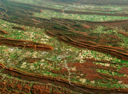
Along with the plentiful harvest of crops in North America, one of the gifts of Autumn is the gorgeous palette of colors created by the chemical transition and fall of leaves from deciduous trees.
The folded mountains of central Pennsylvania were past peak leaf-peeping season but still colorful when the Operational Land Imager (OLI) on the Landsat 8 satellite passed over on November 9, 2020. The natural-color image above shows the hilly region around State College, Pennsylvania overlaid on a digital elevation model to highlight the topography of the area.
The region of rolling hills and valleys is part of a geologic formation known as the Valley and Ridge Province that stretches from New York to Alabama. These prominent folds of rock were mostly raised up during several plate tectonic collisions and mountain-building episodes in the Ordovician Period and later in the creation of Pangea—when what is now North America was connected with Africa in a supercontinent. Those events created the long chain of the Appalachians, one of the oldest mountain ranges in the world.
A Dangerous Storm in the Night
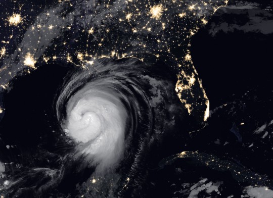
Ominous and looming, a powerful storm hovered off the US coastline illuminated against the dark night hues.
The Visible Infrared Imaging Radiometer Suite (VIIRS) on NOAA-20 acquired this image of Hurricane Laura at 2:20 a.m. Central Daylight Time on August 26, 2020. Clouds are shown in infrared using brightness temperature data, which is useful for distinguishing cooler cloud structures from the warmer surface below. That data is overlaid on composite imagery of city lights from NASA’s Black Marble dataset.
Hurricane Laura was among the ten strongest hurricanes to ever make landfall in the United States. Forecasters had warned of a potentially devastating storm surge up to 20 feet along the coast, and the channel might have funneled that water far inland. It did not. The outcome was also a testament to strong forecasting and communication by the National Hurricane Center and local emergency management authorities in preparing the public for the hazards.
A Windbreak Grid in Hokkaido

From above, the Konsen Plateau in eastern Hokkaido offers a remarkable sight: a massive grid that spreads across the rural landscape like a checkerboard, visible even under a blanket of snow. Photographed by the Operational Land Imager (OLI) on Landsat 8, this man-made design is not only aesthetically pleasing, it’s also an agricultural insulator.
The strips are forested windbreaks—180-meter (590-foot) wide rows of coniferous trees that help shelter grasslands and animals from Hokkaido’s sometimes harsh weather. In addition to blocking winds and blowing snow during frigid, foggy winters, they help prevent winds from scattering soil and manure during the warmer months in this major dairy farming region of Japan.
Shadows from a Solar Eclipse

Formidable, rare, and awe-inspiring — the first and only total solar eclipse of 2020 occurred on December 14, with the path of totality stretching from the equatorial Pacific to the South Atlantic and passing through southern Argentina and Chile as shown in the lower half of the image above. The Advanced Baseline Imager (ABI) on Geostationary Operational Environmental Satellite 16 (GOES-16) captured these images of the Moon’s shadow crossing the face of Earth.
The “path of totality” (umbral path) for the eclipse was roughly 90 kilometers (60 miles) wide and passed across South America from Saavedra, Chile, to Salina del Eje, Argentina. While a total eclipse of the Sun occurs roughly every 18 months, seeing one from any particular location on Earth is rare. On average, a solar eclipse passes over the same parcel of land roughly every 375 years. The next total solar eclipse will occur on December 4, 2021 over Antarctica, and its next appearance over North America is projected for April 8, 2024.
For additional information and a look at more images like these visit NASA’s Earth Observatory.
Make sure to follow us on Tumblr for your regular dose of space: http://nasa.tumblr.com.
#NASA#Earth#science#earth pictures#planet earth#solar eclipse#eclipse#oceans#solar system#planets#space#satellite#stunning photos
2K notes
·
View notes
Text


Dark Nights in Georgia
Hurricane Helene’s winds surged in strength as the storm churned over unusually warm waters in the Gulf of Mexico and closed in on the Florida Panhandle and southern Georgia on September 26, 2024. When the deadly Category 4 storm struck Florida’s Big Bend area and then pushed north, winds in some areas exceeded 140 miles per hour (225 kilometers per hour)—strong enough to snap trees, tear the roofs off buildings, and topple power lines.
After the storm passed, millions of people across several states were left without electricty. The Visible Infrared Imaging Radiometer Suite (VIIRS) on the NOAA-NASA Suomi NPP satellite has a low-light sensor, the day-night band, that measures nighttime light emissions and reflections. It captured views of some of those losses in hard-hit communities in Georgia, including Augusta (above), Savannah (below), and Valdosta (second pair below).
Scientists with the Black Marble Project at NASA’s Goddard Space Flight Center, Science Systems and Applications, Inc., and the University of Maryland, College Park, processed VIIRS data to show nighttime lights before and after Helene passed through the Southeast. Data from September 28 were compared to a pre-storm composite (August) and overlaid on landcover data collected by the Landsat 8 and 9 satellites. These three cities were not the only communities in Georgia that lost power.
Data published by Georgia Power showed that power had been restored to more than 840,000 customers by October 1. However, more than 400,000 Georgians still lacked power on that date, including 65,000 customers in Richmond County (Augusta), 38,000 in Chatham County (Savannah), and 40,000 in Lowndes County (Valdosta), according to data compiled by PowerOutage.us. More than 61,000 customers in Florida, 589,000 in South Carolina, and 383,000 in North Carolina were also without power on October 1.
Precision is critical for studies of night lights, said Ranjay Shrestha, a scientist based at NASA’s Goddard Space Flight Center and member of the Black Marble team. Raw, unprocessed images can be misleading because moonlight, clouds, pollution, seasonal vegetation—even the position of the satellite—can change how light is reflected and distort observations. The processing by the Black Marble team accounts for such changes and filters out stray light from sources that are not electric lights.
“Satellite-derived nighttime lights products like Black Marble are invaluable for capturing widespread outages in distributed energy systems,” said Shrestha. “These images not only reveal the immediate impact of disasters at the neighborhood scale but also provide insights into recovery trends over time, aiding in response, resource allocation, and damage assessment.”
The rate at which power is restored after hurricanes can vary significantly based on a variety of factors. Researchers from Florida Atlantic University and Georgia State University analyzed VIIRS data from Hurricane Ian, which roared across Florida in September 2022, and found notable differences in power restoration rates between urban and rural areas and between disadvantaged and more affluent communities.
NASA’s Disasters Response Coordination System has been activated to support agencies responding to the storm, including the Federal Emergency Management Agency (FEMA) and the Florida Division of Emergency Management. The team will be posting maps and data products on its open-access mapping portal as new information becomes available about flooding, power outages, precipitation totals, and other topics.
NASA Earth Observatory images by Lauren Dauphin, using Black Marble data courtesy of Ranjay Shrestha/NASA Goddard Space Flight Center. Story by Adam Voiland.
3 notes
·
View notes
Text
Among the many victims of Russia’s full-scale invasion of Ukraine are some of the most important ecosystems in Eastern Europe: Ukraine’s forests and protected areas.
The full extent of the damage, however, is unknown. That’s why we are launching a new tool that will help open source researchers track destruction from afar.
In September 2022, Ukrainian environmental researchers visited national parks — which are more resilient to climate change than artificial plantings and support crucial biodiversity—to assess damage to forests and wildlife. Initial findings revealed broken trees, damaged root systems due to trench digging and unexploded munitions scattered across protected lands.
“Forests have suffered a lot on the frontline… huge areas of forests are being mined”, Yehor Hrynyk, an environmental campaigner at the Ukrainian Nature Conservation Group, told Bellingcat. But large parts of Ukraine’s vast national parks, mountainous regions and woodlands are inaccessible for on-the-ground environmental monitoring.
That’s where open source techniques come in.
The OSINT Forest Area Tracker
We’ve launched the “OSINT Forest Area Tracker”, hosted on Google Earth Engine. Our tool compares data collected by Sentinel-2, a satellite which detects changes in infrared wavelengths and can be used to study the health of forests.
The tool reveals the scale and intensity of anomalous changes on land. This narrows down search areas for researchers working on environmental damage in Ukraine.
Importantly, the map does not attribute the cause of these changes, meaning that it is crucial to find corroborating evidence from other sources before concluding that they were the result of military activity.
The tool uses the Normalised Burn Ratio (NBR) index to estimate burn severity.
Researchers can also use the tool to select custom date ranges for geographic locations of interest.
As Ukraine’s official database of protected areas includes over 7,500 sites, we chose not to study them all — among their number are botanical gardens, city parks and archaeological sites. That list also includes many areas in the far west of the country which have not seen intense conflict.
Therefore, we selected 16 areas which featured the highest number of detected fires over the first year of the war, based on Moderate Resolution Imaging Spectroradiometer (MODIS) data. MODIS is a sensor which allows satellites to detect thermal anomalies, including fires in active war zones (Along with VIIRS, MODIS data can be accessed on the FIRMS system; you can read more about its use to open source researchers here). We also added Svyati Hory National Park because of its proximity to fighting. The tool includes a drop down list preset areas from across the country, including those near military activity. These preset areas are referred to by their acronyms, for example SHNP for Svyati Hory National Park. A full list of these acronyms can be found on the tool’s GitHub page. If researchers are interested in areas of the country not included in the dropdown menu, the coordinates can be entered manually.
While the new tool focuses on Ukraine by default, the methods it employs could be used to analyse areas elsewhere in the world.
...
Future Development
In the case of Svyati Hory, the tool identified damage to a protected area which deserved further investigation. In the case of the Kinburn Spit, it allowed us to further verify existing open source claims about an attack which had caused damage to a forest – also enriching our knowledge about the extent of the damage, which was less easily visible on real colour satellite imagery. However, both cases demonstrate the importance of corroborating the tool’s findings with other sources before drawing any conclusions about the causes of such damage. The author will continue refining and improving this tool in order to better understand the scale of damage to Ukraine’s many protected areas. Feedback or suggestions for improvements are welcomed. For further technical details on this tool and updates following the publication of this article, please read the description on the author’s GitHub page.
20 notes
·
View notes
Text
Why Googlemapembed.Com Is A Method Not A Approach
just How To Embed Google Maps In Wordpress site
As an example, a look for a map of Boston on Google.com would certainly produce, to name a few things, a topographic map of the city through Google Maps. The Maps program allows users to zoom in and out and move the map to search bordering areas. Along the appropriate side of the search results page screen are a variety of little ads for Boston-based services, hotels, dining establishments, as well as links to other sites selling hard-copy maps of the city. This type of paid advertising is the main method which Google makes its profits.
deleting A Google Map.
What is MAP API?
A Map API (also known as Mapping API) provides location intelligence for software developers creating location-based products and services. It is the base building block for location-aware applications, feature-rich maps and the retrieval of geographic-related data.
In a feeling, when you go abroad, Google Maps really begins to radiate in a manner it doesn't in the house. Mr. Robinson claimed his group asked Google to include the East Cut to its maps. A Google spokeswoman stated employees manually put the name after validating it through public sources.
Google's 360 degree Street Sight function is available in the Android variation of Maps application. The most basic method to gain access to this attribute is to find the area you wish to view, and also press and also hold that place. If a Road Sight is available, a little thumbnail will show up in the lower edge. By default, this app draws every one of its information from Google web servers in real time. It is possible to pick an area as well as download it for offline use, nonetheless.
In Rio de Janeiro, just 26 of the city's 1,000 favelas are mapped-- this despite the fact that the favelas are home to over a million people and also regarding a quarter of the city's populace. After all, Google itself is so embedded to our ordinary tech lives, we rarely think of it as having a professional application to something as interesting as traveling.
What is the URL mean?

A domain name is part of a URL, which stands for Uniform Resource Locator.
There are also data-sets that let you viewvirtual designs of the moon and other earths. Zoom Earth is just one of the most effective options to Google Earth only since it does not utilize much of Google's services for data mapping and yet provides fantastic images of our Earth. Similar to Google Earth, Zoom Planet is online and it reveals real-time info of weather condition, tornados, wildfires, and extra. The best component is that you can see high-resolution aerial views of the lots of areas in a zoomable map. While Google Planet is excellent, there are few other alternatives that can assist you do the same points.

data.
Is the YouTube API free?
Yes, using the YouTube API does not incur any monetary cost for the entity calling the API. If you go over your quota an 403 Error will be returned by the API. Yes it is, but some restrictions like limit you can use only 100000 units per day. and 3000 per second per 100 user per day.
Use the Print menu approach explained in the write-up above or record a screenshot onto your computer system and also print out the screenshot. If you don't wish to really publish however wish to maintain a copy on your phone, simply take a screenshot or display capture and also leave it in your photos folder/desktop view.
This Is Google's New Smart display tool.
Many individuals are not delighted with Google's data collection policies and do not want to hand over information greater than they have to. If for that reason or a factor of your very own, you are searching for Google Earth alternatives then you have pertained to the right place. Here are the 4 ideal apps like Google Planet you can utilize in 2020. Google Earth enables you to take a trip, discover, and learn more about the world by interacting with a virtual world. You can view satellite imagery, maps, terrain, 3D structures, and far more.
Google says it utilized satellite images as the basis for its revamped maps which this has had a "new color-mapping mathematical technique" put on it. Completion outcome does a much better job of showing off the differences between natural functions, such as between snowy tops and thick forests or environment-friendly areas and also sandy coastlines. The contrast shots listed below offer a concept of what the new color-mapping strategy is capable of. Google Maps is being upgraded to make it simpler to compare natural attributes in the environment, whether they're mountainous ice caps, deserts, coastlines, or thick woodlands.
What is a map URL?
The maps URL scheme is used to show geographical locations and to generate driving directions between two points. Unlike some schemes, map URLs do not start with a “maps” scheme identifier. Instead, map links are specified as regular http links and are opened either in Safari or the Maps app on the target platform.
Go to the major Google Maps internet site and type the address for the home you want to check out. This will show an overhead map of the property on screen. Click the "Street Sight" button to watch pictures of the residential or commercial property drawn from street degree by Google's very own Street Sight vehicles that circumnavigate the globe. Yes, a map can be published from Google Maps, either with or without directions.
But for lots of areas where homeowners were not sure of the history, authorities depend largely on Google. The Eye and others are now part of that official map.
So Google Maps started its trip greater than a decade back, worked in the direction of incorporating numerous applications.
In 2004, Google got this company from the bros.
The best component of training course is that Google Maps as well as all its related services are used absolutely free.
And finally launching Google Maps application in 2005.
Ultimately integrating it with various other business which Google purchased over the next couple of years related to live traffic analyzer as well as various other mapping related applications.
This feature supplies a powerful tool to present historic datasets. It does have restrictions, nevertheless, as Google Maps will only import the first 100 rows of a spreadsheet.
Maps and also images you create in Google Maps as well as Google Planet can be saved as KML documents This suggests you can conserve job performed in Google Maps or Google Planet. With KML files you can transfer information in between these two systems and also bring your map data into Quantum GIS or ArcGIS. Note that to the right of Layer there is a https://googlemapembed.com checkbox-- unchecking this box turns off (i.e. it doesn't appear on the map) a layer and its info. Uncheck the UK Global Fats layer and also click Layer 1.
1 note
·
View note
Text
Zoo Story: The Future
Have an online walk through the past, present and future of the Lisbon Zoological Garden with the Gulbenkian Foundation, which was online before the online event started.

Map of the original edition “Guia do Turista em Lisboa” (1929) [property of Manuel dos Santos and Ascenção Araujo, Lisbon] modified by the curators with the satellite image of Lisbon (2020).
The project for the Future Architecture Platform 2020 will take you to the Lisbon’s Zoological Garden designed by Raul Lino asking questions like what role is the Zoo expected to fulfill in the contemporary city and what will it be in the future? For more check up online virtual exhibition “Staged Nature: Zoo of zoos” curated by Enrico Porfido and Claudia Sani from País(vi)agem with Arian Lehner and Theresa Margraf from Mies.TV, with whom we had a short talk about it.
---
How do you see the future? Enrico Porfido: Do you mean the future of the zoo or the future in general? Because I don't really see any future coming... In this direction, with such a pessimistic interpretation of the imminent future, it doesn't make sense to make many plans for the future. But hidden somewhere, there is also an optimistic point of view where, “thanks” to COVID-19, this crisis represents an opportunity to change our way of living, interpreting and reading our realities. During the study and research phase for the exhibition in Gulbenkian Foundation we understood that the Zoo is not only a place where animals are kept, but it is a place where different themes can be discussed. For example, our approach to nature, its valorisation and the relationship with the historical city. It’s not only an issue of animals in a cage, but our anthropocentric approach to reality! If we can start changing it in the zoo, we might be able to change it also outside it, in our everyday life.
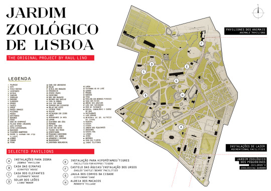
The original map of the Lisbon Zoological Garden, designed by Raul Lino at the beginning of XXth century | Source © Archive of Gulbenkian Art Library
How did you develop this project in the time of pandemics? Arian Lehner: The whole development of this project was very interesting, because we were all apart, in different cities. In the process of creating the exhibition we had a lot of discussions, where we very early understood how to talk about the zoo as an urban piece in the city. One important point which triggered an idea and vision for the future, was the thought of a biologist, who said that the zoo is showing naked animals itself without their natural environment. Such spaces like a zoo might in future show a variety of glimpses into different places of the world, where it won’t necessarily be needed to keep living animals in cages.
Why is then important in the whole environmental context? Arian Lehner: A zoo can transform into a condition of heterotopia which creates different worlds inside it. Animals will be linked to their environments to understand what is relevant to survive. It is a glimpse into the world, within your own city so you don’t have to travel around the world to understand other ecosystems.
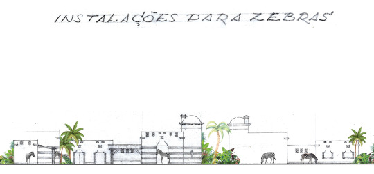

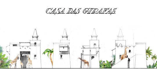
Zebra, elephant and giraffe pavilion house designed by Raul Lino. | Source © Archive of Gulbenkian Art Library
You used different media for dissemination of the project, could you explain more? Enrico Porfido: More than innovative, I would rather say that we were complementary. We are two groups that cover different dissemination channels and networks. AtPais(vi)agem we are more traditional-academic, while Mies. TV has a more digital approach. I think it worked well because we mixed those two worlds!The main idea was to enlarge the public audience of the Gulbenkian Foundation’s archive within sharing their drawings via digital tools. So, we decided to drop an old-fashioned-paper archive in a contemporary digital media! This goes in the direction that the Gulbenkian Foundation took even before COVID. Indeed, they already had in mind those virtual exhibitions as instruments for making their archives accessible to as many people as possible.
Which types of media did you use? Arian Lehner: Because of the huge variety of new media, we did not fear of putting theoretical architecture-content in this new digital field. If you can buy shoes on Instagram, why can’t we use the same platforms for academic discourse as well? Our goal was to bring the content of Pais(vi)agem to as many people as possible in an understandable way. The exhibition consists of short and long texts, short and long videos, animations, sounds in order to make it understandable. Our exhibition is not closed but it’s a kind of open source, where you can learn and link to many other sites. Such as the cooperation with postcards by Modern in Belgrade

Postcard from Belgrade: "Belgrade Zoo's Ark: A Voyage to the Great War Island" designed by Hristina Stojanović, Modern in Belgrade.
The cooperation with BINA - Belgrade international week of architecture? Enrico Porfido: The collaboration with BINA was a nice experience, although we couldn’t develop it as much as we planned due to COVID restrictions. During the digital talk in September, we compared the zoo situation between Belgrade and Lisbon with local experts and this was really inspiring. And it also ended up in an ephemeral collaboration with the collective Modern in Belgrade, that supported our project sending some “postcards” from the Belgrade’s zoo.
Creating an open-source exhibition? Arian Lehner: This is a process of democratisation of information. We created a digital exhibition that doesn’t translate everything into representation through worlds or images drafted by the curators. What we have is live interviews with experts in the zoo, we didn’t do any representation or transcripts but left the video without the filter so you can listen directly to the experts themselves.
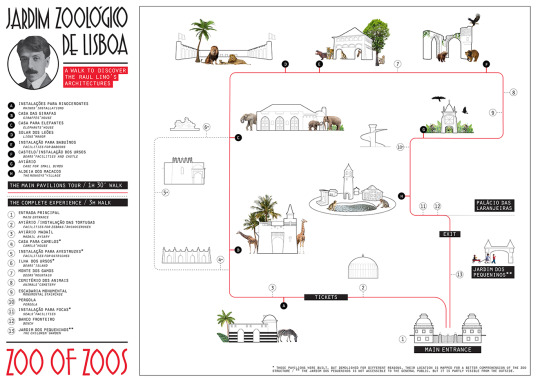
Map "A walk to discover Raul Lino's architecture in the Lisbon Zoological Garden" designed by the exhibition curatorial team
An amazing change of discourse and presentation coming from an institution like Gulbenkian; what did Future architecture bring to you? Enrico Porfido: From our experiences, there are many new synergies coming out from this adventure. During the Future Architecture fellowship, we started to build new connections and to consolidate our network. This platform has this big added-value of generating interesting synergies. In our small collective, we decided that there is no more time to work for somebody else or being employed for somebody that you don’t want to work for. We decided it’s time to do something different, because we have limited time to express ourselves. We are aware of what our generation of architects is doing today and which are our opportunities to raise our voice without being arrogant.
Arian Lehner: This current fear or the future has a global dynamic. It is not restricted to one nation alone, but the entire planet is facing challenges. Future Architecture Platform is some kind of global dynamic too – obviously a positive one – which is very important because we work within a transnational network and dissemination of information and knowledge.
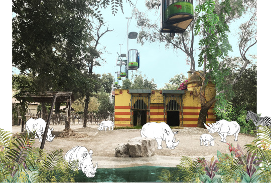
The Rhinoceros' pavilion | Photo, illustration by the exhibition curatorial team
What would you say about the future after this talk Enrico? Enrico Porfido: That we have a long way to go! Especially for making people understand that architects do not only design houses. Architects are not just builders! Our superpower is to read reality and territories. There are many tools that we can use, in such a way architects can work as coordinators. We can gather and guide different experts from biology, ecology, anthropology, history, etc. because we can understand the territorial dynamics and coordinate different expertises. Territories have different scales within themselves and architects have the sensibility to understand, observe and work within them.
Is this something connected to a generation? Enrico Porfido: I guess it’s the approach we have to reality. The oldest architects’ generation would probably answer this question in the same way of how they work – alone.This is why we had so many names, the archistars of the recent past and present. But there are not 30yo archistars, why?

The Elephants' pavilion | Photo, illustration by the exhibition curatorial team
How could we develop tourism so that it could work as a creator of new destinations? Enrico Porfido: We can change the way of planning tourism but there is one thing that we all need to understand:we are all tourists at somebody else’s place. You don’t like to hear chatting in the bar under your place, but how is it when you visit another city? I don’t think you care much about the residents.I am obviously generalizing, but here in Barcelona we see the tourist issue as a really strong problem. I can agree that the massive tourism brings along some negative aspects, but we all need to learn how to cohabit. We need to be more tolerant as residents and more educated as tourists. We need to find new models for tourism. I have no clear idea how we should plan the tourism of the future, but I guess people will start to travel more for knowledge and for experiencing the reality of a specific place. Tourism is a social phenomenon, so when the society “goes massive” also tourism does it.

The Giraffes' house | Photo and illustration by the exhibition curatorial team
Arian Lehner: Psychologically speaking: I travel to somewhere far away because I want to experience different smells, sounds and newspaces. This uniqueness makes travelling attractive, rather than staying at home in the monotony of one’s own life. The important part of visiting places is that you are “only visiting” and many places you just want to see but not live there for the rest of your life. It’s really like a refreshment and before coming back to your monotonous life, which is also safe. Are there different ways though that can create the same effect of travelling somewhere else, diving in a completely different world, place, space? Maybe this could in future be visiting your local zoo because everything will look different, because of different elements that this place is composed of, maybe it is a techno park with different robots. In this way you don’t need to fly away somewhere else to be yet again in a city that has the same Starbucks, the same looking Airbnb – but you can have a different psychologically effect like visiting a different place. That is an interesting challenge.
---

Staged Nature: Zoo of zoos: A walk through the past, present and future of the Lisbon Zoological Garden, Gulbenkian Foundation via Future Architecture Platform, 2020 (illustration exhibition curatorial team)
País(vi)agem is an independent research group, which aims to investigate the relation between tourism, landscapes and local communities, co-founded by Enrico Porfido and Claudia Sani in 2015. Enrico is based in Barcelona and working as researcher and freelance consultant on tourism and strategic planning. Claudia became a project manager in the office Urban Act in France, dealing with urban ecology and social district regeneration. In 2020 Elisa Brunelli joined the members’ board.
Mies.TV is a documentation and investigation platform with the goal to initiate discussion on the topic, resolve understanding and reflect on how the role of an architect is changing. The channel has filmed over two hundred interviews ensuring a vast archive of data to enable a thorough and widespread illustration of different standpoints and how these are positioned within a global perspective. Through open screenings, architecture festivals, television shows and panel discussions aims to communicate architecture to an audience internal and external to the realm of architecture with the use of modern tools.
1 note
·
View note
Text
Lore Episode 130: In Plain Sight (Transcript) - 25th November 2019
tw: none
Disclaimer: This transcript is entirely non-profit and fan-made. All credit for this content goes to Aaron Mahnke, creator of Lore podcast. It is by a fan, for fans, and meant to make the content of the podcast more accessible to all. Also, there may be mistakes, despite rigorous re-reading on my part. Feel free to point them out, but please be nice!
In early winter of 1822, Captain Samuel Barrett Edes became a hero. He was sailing in the south-east Pacific when he and his crew encountered a Dutch ship that was in trouble. Edes managed to save every single one of the Dutch soldiers, and then headed for the city of Batavia, known today as Jakarta, to drop them off and see if a reward could be collected. While he waited, he did some shopping. Now, Edes wasn’t rich by any stretch of the imagination, but he owned a small portion of the ship he sailed and of course, he was expecting a handsome reward for his heroic efforts. With this in mind, he kept an eye open for something unusual and conversation-worthy to take home, and that’s when he saw it. It was a mummified mermaid. It was over two feet long, had the curved tail one might find on a fish, but the upper body of something much more human in shape. It was brown from the preservation process, wrinkled with age and entirely addictive to look at, and Captain Edes knew instantly that he had to own it. In late January of 1822, he did something bold. He sold the ship he did not fully own and used the proceeds to buy the mermaid. Then he found transportation back to London and put the odd creature on display, because just about everyone who saw it believed that it was real.
Of course, there were those who could see through the hoax. Captain Edes had been fooled by a clever craftsman who had sewn the torso of an orangutan onto the lower half of a large salmon. Elements were added to the face and hands to give it a more humanlike appearance, but those with training in natural science and anatomy could spot the hidden clues that gave it all away. That didn’t matter to most people, though. The idea that mermaids could be real had been around for centuries, so when something as powerful as a mummified specimen floated into their world, they were blind to its flaws and impossibility. They wanted to believe, deep down inside, that the hybrids of folklore actually existed. Today, we know a lot more about our world than we used to, but if we were to go back in time and live through a less learned age, we would be amazed at the stories that await us, tales of creatures that sit at the very edge of our imagination, living things that defy logic, and monsters that inspire wonder. Our hearts want to believe while our minds are ready to move on. Instead, what we tend to feel is a mixture of deep curiosity and primal fear, and if the tales from the past are any indication, there’s a good reason why. I’m Aaron Mahnke, and this is Lore.
When we talk about the natural world, the very first thing we need to do is gain some perspective. Today, we live in a technologically rich society. We carry supercomputers in our pockets that are more powerful than the ones that sent the first humans to the moon. We can walk past an intriguing part of our neighbourhood, pull out our phones and look at a satellite map or do a search for more information. We’re still hungry people, curious and drawn to unanswered questions, but rather than starving in a house with little food, we feast each day on a never-ending buffet of answers and information. Today, if you want to know something, chances are good you can learn about it in an instant, but hundreds of years ago, that was an impossibility. Not that people didn’t try, though. 2000 years ago, a Roman named Gaius Plinius Secundus attempted to gather everything knowable into one place, and he did an admirable job considering the world he lived in. Gaius was born into a wealthy Roman family in the year 24AD and followed a path of privilege all the way to the top. He was well educated, well connected, and when he entered the Roman military, he quickly rose to the second highest level possible – the equestrian order. Once out of the military, he served as a lawyer, before being assigned various governorships around the empire, and towards the end of his life, he had the privilege to serve as advisor to two different emperors. Today, we know him as Pliny the Elder, but in his day, Gaius was a success story.
Looking back, his biggest legacy was his 37 volume collection of knowledge called Natural History. It was possibly the world’s first encyclopaedia, gathering everything known about a whole array of subjects, from farming and botany to geography and anthropology, but the most influential contribution, filling up volumes seven through 11, were his writings on zoology, the study of all living creatures. But here’s the thing – Pliny the Elder, like everyone else in his society, lacked the proper tools to dig deep and apply hard science to every creature he wrote about. He also lacked the ability to travel and see each animal he described, so he relied heavily on others, like Aristotle’s Historia Animalium and the writings of Eratosthenes and Hipparchus, and that meant his collection was less than perfect. How so? Well, his work on zoology included such amazing animals as dragons, mermen, and even something called a blemmyae, a race of hairy, human-like beings who literally had no head on their shoulders, with eyes and a mouth right in the middle of their chest. Pliny was thorough, for sure, but not very discerning with his source material.
But what his work did do was give birth to something a lot of people have heard of, a type of book known as a bestiary. It took a while for their availability to spread, but by the early middle ages, bestiaries were a common enough resource. They were, at the basic level, books about known animals, typically with colourful drawings to help the reader visualise the specific details of each entry, and over the centuries, some editions became more popular than others. One of the most famous is the Aberdeen Bestiary, an illuminated manuscript that dates back to the 12th century. Aside from being a beautiful example of medieval artwork – and I mean that, you should seriously do an internet search for sample pages – the Aberdeen Bestiary is also a powerful example of just how popular these books really were. It’s filled with images of all sorts of animals, along with rocks, fish, trees and even worms, and a lot of the entries in the manuscript include notes about the nature of the thing in question, making it a valuable reference tool for any budding naturalist. But these bestiaries did more than that – they inspired the popular culture of their day.
England’s King John, who reigned from 1177 to 1216 was said to have a copy of Pliny the Elder’s Natural History in his personal collection, and John’s son and successor, King Henry III, even used images from it to decorate one of the chambers at Westminster. As their popularity spread, more and more writers got in on the tradition. The Norman poet Philip de Thaun wrote a bestiary about a generation after William the Conqueror invaded England, and it became a gift for King Henry II’s wife, Eleanor of Aquitaine. Even Leonardo da Vinci made one. It seems if you were an intelligent person in the middle ages or the Renaissance, making your own bestiary was practically a rite of passage – and let’s be honest, colourful manuscripts filled with unbelievable creatures and animals that defied logic couldn’t not be popular. Humans have this innate desire to look at curious things. We’ve always been rubberneckers, straining to take a long, hard look at things that sit outside our normal experience, and the spread of bestiaries is proof of that. But those ancient books and manuscripts also teach us something else about ourselves. Human beings are creative creatures. When faced with a mysterious gap in our knowledge, we’re more likely to invent something to plug the hole than to leave the question unanswered – and what we’ve come up with is equal parts entertaining and downright terrifying.
I mentioned earlier how the internet and the accessibility of powerful devices has given us an edge over our predecessors, and in a lot of ways that’s true. Yes, we have access to a huge majority of our collective knowledge, but not all of it. In fact, there are still things we don’t know. For example, scientists today believe that there are roughly 8.7 million animal species on this planet, and yet 86% of the ones that would live on land still haven’t been discovered or studied, and it’s even worse inside our oceans, where over 90% of life is still a mystery to us. We know a lot, yes, but our world is massive and diverse, and that makes the learning process slow and tedious. Some animals are also a bit harder to track down, they’re less abundant or more shy, and so it’s made studying them more of a challenge. A good example is the platypus. For a very long time, scientists thought the descriptions of it were nothing more than a hoax. I mean, it was rumoured in 1799 to be a hybrid of a duck and a water rat, part mammal and part bird, with venomous spurs that could kill a dog, and while we’ve learnt more about them over the years, the platypus is still an allusive creature. A recent documentarian was able to get what he considered to be a goldmine of actual footage of the animal, amounting to about 30 seconds, and when only half a minute of film is something to celebrate, you know the animal is hard to study.
Of course, while we’re searching for new species, the ones we do know about are slowly dying off, which doesn’t help. Some estimates place the number of species on the edge of extinction at around 20,000, and more get added to that list all the time. For the medieval writers of bestiaries, this would be their worst nightmare. All those creatures belong in their books, and yet they keep slipping away. But at the same time, not being able to see an animal never really stopped those ancient writers from including it in their catalogue of life on earth. In fact, there are a lot of entries that would cause most people to scratch their heads, because while, yes, we’ve grown in our understanding of the world around us, these bestiaries serve as a time capsule of our gullibility. As far back as Pliny the Elder’s collection on natural history, we can see those less believable creatures pop up. He once wrote that thousands of sea-nymphs known as neriads had washed up on the shores of what is modern day France, and that they looked just like the nymphs of the land, except that they were covered in fish scales. He also wrote about that fiery bird of legend known as the phoenix, which was known to burst into flames before re-emerging from its own ashes. And of course, I’ve already mentioned his fascination with mermen and blemmyae. It seems that Pliny the Elder had an obsession with gathering all known creatures, whether or not he had witnessed them with his own eyes.
Other historians added their own contributions to those mystical lists as well, and if I ran through it for you now, it would sound like a recap of the Harry Potter series. Hippos and elephants shared the same space as hippogriffs and mandrakes. There were dragons and tritons, giants and sea monsters. Honestly, it sometimes seemed that if a young child could draw a picture of it, that was good enough to get it included. Of course, some creatures were more popular than others, and that popularity varied from culture to culture. In Europe, one of the most talked about creatures of all was also one of the smallest, but don’t let its size fool you, because there was nothing safe about the basilisk. Our old friend, Pliny the Elder, wrote about it 2000 years ago, describing it as a serpent with legs that was no larger than a foot in length. But what it lacked in size, it more than made up for with attitude and special features. A basilisk was said to stand tall on its back legs and had a crown-like plume on top of its head. And they were dangerous, too – according to the stories, basilisks were so poisonous that even looking at them could get you killed. Other creatures avoided the like the plague, and wherever they chose to make their nests, the plant life would die and wither away. One description I read said that if a man on horseback stabbed the basilisk with a spear, the poison was so powerful that it could climb up the spear, kill the man, and then kill the horse as well.
Of course, when something is that powerful and deadly, it eventually becomes the centrepiece of tales of valour. It’s said that Alexander the Great once killed a basilisk, and like many of the other legends about him, he did it in a way that proved not just his might but also his intelligence. It’s said that he polished his shield until it was like a mirror, and then approached the creature holding it outward. When the basilisk saw its own reflection, it fell victim to its poisonous gaze and instantly dropped dead. We can find images of the basilisk in just about every bestiary in existence, most of which look like a cross between a snake and a rooster. There’s a statue of one in Vienna, commemorating an 11th century hunt, and there’s even a church in Sweden with a carved relief showing St. Michael stabbing one with a spear. So popular was this creature that people sold powders that they claimed to be ground-up basilisk, something that most people purchased for use in alchemy, but more than a few used as an antidote to poison. Everywhere you look through the middle ages and earlier, the basilisk is waiting to rear its poisonous little head. You can see society’s attraction to it in their folklore and superstition, a mixture of fear and fascination, of wonder and disgust. For centuries, it popped up in stories whispered all around Europe, like a well-loved character in a popular book series. But if one account is any indication, it might not be a work of fiction after all.
The people of Warsaw had a problem on their hands. They were two decades into a new political structure known as the Polish-Lithuanian Commonwealth, and while it gave a lot of freedom to the wealthy and elite, it left the lower class in a constant state of fear and oppression. Life in the city was challenging for many people, but that was the new normal. In 1587, though, something happened to put the people of Warsaw on edge. Livestock in the area around an old, ruined building had begun to turn up dead. Even a few of the neighbouring residents had been found poisoned in their beds, washing over the community with a wave of grief and loss. And in the midst of all that confusion and pain, two of the neighbourhood children disappeared. Well, disappeared might not be the right word for it. Folks had seen the two young girls playing near the ruins, they had watched them laugh and skip and revel in the freedom and joy that came with childhood, most likely muttering quiet prayers that it would last as long as possible. The neighbours knew what sort of hard life awaited those girls once they were old enough to work and carry their own weight. Their joy must have been bittersweet.
And then someone watched them step inside the ruins. That was the first reason to worry. Folks avoided the ruins for a good reason – it was dark and dangerous, and the cellar beneath it had been a den for all sorts of animals. So, whoever it was that watched them disappear into the shadows most likely headed over to warn the girls’ parents. When everyone arrived at the ruins to call them out, though, they were no longer visible. While there was a good chance they had simply moved on to a new playground, someone decided to peer inside the dark cellar, and there, laying on the broken stone floor, were the sleeping forms of both girls. So, one of the older women stepped inside to wake them. A moment later, though, she collapsed into a heap beside the girls, sending the growing crowd into a panic. They didn’t know what was causing the people inside the cellar to lose consciousness, but they knew there was something dangerous about the dark space, so they sent for a fire hook – a long pole with a metal hook on the end – and then reached in and pulled each body out into the light. All three of them were dead, and not just dead – they were bloated and dark, as if they’d been dead for days. Most frightening of all, though, was that their eyes seemed to be protruding from their sockets. No one could be sure, but it almost looked as if they’d been frightened to death.
Wanting answers, they sent for Benedictus, the king’s very own physician. If anyone would have the skill to identify the danger, it would be him. And, sure enough, after taking a long look at the trio of bodies, he brought them a definitive answer. All of them had been killed by a basilisk. In an instant, the atmosphere around the old ruins changed. Newcomers came to watch, while leaders gathered to form a plan. Something had to be done, and just like the stories all of them had grown up with, it seemed that a basilisk hunt was in order, but the trouble was no one wanted to risk their lives by entering the cellar to kill it – not even Benedictus, who seemed to know the most about the creature. But they had an idea. A group of leaders from the community quickly headed to the local jail, where two men awaited execution for various capital crimes. Each man was given the same offer: come kill the basilisk, and you will receive a full pardon and your freedom as a reward. It seemed like an easy choice, too – inside jail, there was no chance of survival. Outside, though, there was at least the possibility they might survive. It made sense to everyone.
The first criminal declined the offer, but the other one, a man named Johann Faurer, agreed to help. He was escorted from the jail to the old ruins, where Benedictus awaited him with tools and instructions. The townsfolk had quickly gathered dozens of small mirrors and sewn them onto a pair of leather pants and a coat. I imagine Johann gave the old physician a sideways glance at the sheer ridiculousness of it all, but at the same time, he would have known the folklore just as well as everyone else. Alexander the Great had defeated a basilisk using a mirror-like shield, so why would it not work for him? With a crowd of over 2000 witnesses watching, Johann began to carefully walk into the ruins, where he entered the cellar. He had a long rake in one hand and a torch in the other, to light his way, and as soon as he stepped into the darkness below, he cried out that he could see it – a long, serpent-like tail, with a head that resembled that of a rooster, right down to the crown-like plumage. Benedictus called out instructions to the man. “Grab it with the rake,” he told him, “and then carry it out here into the light.” Johann shouted back that he understood, and the entire crowd began to shift and rumble. If a basilisk was going to be dragged out of the ruins, no one wanted to be around to see it, so they all ran for cover and hid their eyes. When Johann emerged, he held the writhing creature by the neck in one of his gloved hands. They daylight somehow made it weaker, and that gave Benedictus the courage to step closer and examine it. It looked exactly like the bestiaries of old had taught him – the body of a snake, four long legs and a head that looks very much like a rooster.
But sadly, this is where the account of the basilisk hunt ends. Whoever had been recording the events had most likely been in the crowd, and when Johann had begun to emerge from the cellar, they had followed the crowd into hiding, which leaves the ending a bit of a mystery. Who killed the creature, when all was said and done, and how did they do it, knowing the risks the old legends spoke of? What we do know is this: the Warsaw basilisk hunt of 1587 was the last time the creature was reported anywhere in Europe. Maybe it had been the last of its kind, and its death marked its extinction, or perhaps the few that survived had a knack for staying out of sight – like the platypus of Australia. Either way, all that was left from that moment on were legends and stories. Like so many creatures that have once walked the earth, the basilisk – if it was ever real to begin with – has slipped into the shadows of the past, and it’s never been seen again.
There really is something delightful about the bestiaries of old. Their colourful pages and evocative descriptions were beyond sensational. In a world without television, radio or easily accessible works of fiction, those catalogues of natural history were the closest most people could get to travelling the world. Of course, the things most authors chose to include in their bestiaries would probably never make the cut in our modern times. After all, headless tribesmen with eyes on their chests, unicorns and sea nymphs all feel more like characters in a fantasy novel than entries in a study on the world’s flora and fauna. And yet some of those expectations have been broken over the years. For centuries, sailors told stories about the kraken, enormous sea creatures that could reach out and drag an entire ship underwater with its long tentacles. King Sverre of Norway recorded its description way back in 1180, and for hundreds of years people claimed to spot them in the waters of the ocean. Then, in 1853, the carcass of a giant squid washed up on a Danish beach, giving the legend new life. Over the century and a half since then, scientists have determined that there is indeed a giant sea creature that fits the ancient descriptions – give or take a few sinking ships, of course – and while they’ve been challenging to catch on film, we now know they exist. And those mermaids of old might have roots in actual animals as well. Many scientists and scholars now believe that old reports of mermaids could very well be mistaken sightings of an aquatic mammal known as the manatee. As is so often the case, our misunderstandings had given birth to frightening legends, only to have science bring a bit of clarity to the tale. Sometimes the monsters of the ancient world turn out to be real, and sometimes legends inspire new discoveries.
In the part of the world that stretches from Mexico to South America, scientists have been familiar for over a century with a lizard from the iguana family. It’s not the largest reptile around, but it can grow to around 2ft in length, and it can run at amazing speeds. Some scientists refer to it as the Jesus Christ Lizard because of its strange ability to run across the surface of water. But its most common name is based on other features, like its tendency to run on two legs and its serpent-like body – a body that’s topped with a head and plumes reminiscent of a crown or a rooster, which is why its name is both logical and a bit of a throwback. They call it the basilisk.
There’s something enticing about the mysteries that fill the gaps in our knowledge of the world around us. Looking back at the bestiaries of the middle ages, its clear humans have had a lot of fun filling those holes, and the creativity of the past has continued to inspire stories today. But there’s one more creature I want to tell you about. Stick around after this brief sponsor break to learn all about it.
[Sponsor break from Bombas, Casper and Fracture]
They had fallen in love, and it was something that would change their destiny forever. At least, that’s how the legend tells it. Long ago, a young man lived on a small island surrounded by deep blue seas, and in the process of hunting one day, he encountered a beautiful young woman. But the hunter quickly learned that there was more to her than he could see with his eyes. The woman, it turns out, was a fairy. In fact, she was well known to the locals there, who referred to her as the Dragon Princess. Despite their differences – him, a normal human being, and her, a magical fairy – the two of them fell in love and were soon married, and that helps this tale become on of those happily ever after stories that we all love so much. The couple went on to have twins, a boy and a girl, and just like their parents, they were an odd pair. The boy was just like his father, a human with no magical powers of his own, while the girl took after her mother, and because of that, both parents decided that the children should be raised in separate places to help them fully become who they were meant to be.
According to the legend, it was many years later when the son was out hunting, just as his father had taught him. He was creeping through the forest, his spear balanced in one hand, when he spotted a deer. He quickly threw the weapon, which found its target, and a heartbeat later the young man was carefully making his way over to collect his prize, and that’s when the dragon stepped out of the trees. It was enormous and frightening, and it clearly wanted to take the deer that he had just killed. The young hunter spoke to it, begging it to leave his future meal alone, but the creature ignored him and proceeded to move toward the deer, so he lifted another spear and got ready to take aim at the dragon. Suddenly, a figure stepped out of the shadows of the forest and stopped him. It was his mother, the fairy princess, who he had not seen since his childhood, and as she approached him, she spoke a word of warning. “Do not throw that spear”, she told him, “for that is no ordinary dragon. That is your sister.” Instead, she taught him to live in harmony with his sister, and according to the legend, that fateful meeting set the destiny of their entire community on a new path. Even today, if you were to visit the place where they lived, the people there would tell you that they are descended from dragons, illustrating how that harmony has continued.
And of course, this story is just one of many tales about dragons that fill the pages of folklore. In fact, most of us would be hard pressed to find a creature mentioned more often than those magical beasts, from the 11th century legend of King George and the Dragon to the fantasy novels and television shows of our modern world. They really do seem to be the king of monsters. Dragons are also one of those nearly universal creatures. It seems just about every culture around the world has had some version of them in their folklore. The ancient Egyptian god of chaos was Apophis, represented as a giant serpent. The Babylonians had their own god of chaos called Tiemat, and in Arcadian mythology there were not one but three dragons on display. Norse mythology features a giant serpent who gnaws at the roots of the world tree. In Ukrainian folklore, there is a dragon with three heads, while images of dragons can be found all over medieval heraldry. And of course, few cultures on earth hold as tightly to their dragon mythology as the Chinese, who have been decorating objects with images of the creature at least as far back as the Neolithic period, and we could speculate why, I’m sure. It doesn’t take a lot of imagination to see how the accidental discovery of dinosaur bones might spark fear and wonder in the minds of humans thousands of years ago. The places where stories of dragons are most common are also places where such fossils have been uncovered, so it does make sense.
So, when Europeans arrived on an island in the Flores Sea, just south of Indonesia, they probably didn’t think twice about the local stories about dragons. In fact, those tales were probably a bit old hat, as they say. Dragons lived in caves, breathed fire, were vicious killers and could fly when necessary – nothing about all of that was new. What was new, though, were the things they saw there. On an island surrounded by deep, blue sea, an island full of people who believed they were descended from dragons, mind you, they discovered a creature that brought all of their legends to life. It lived in the caves along the shore, it was an enormous killer, and it sometimes even followed its prey up into the trees. It ticked all the boxes. These were 300lb serpent-like monsters that could bring down a half-tonne water buffalo. When they licked the air with their bright red tongue, it looked as if they were spitting fire, and they even dug into the graves of the dead looking for treasure. Of course, that treasure was always food, not gold. And they’re still there, crawling across the sandy beaches of the island, living in harmony, more or less, with the people who still call the place their home. They might not have wings or piles of golden treasure to curl up on, but they are the largest lizard on earth, measuring in at over 10ft in length, and they’re deadly. Sometimes the tales of the past stay shrouded in mystery, and other times we manage to crack the riddle and shed new light on the shadows that once frightened us. This living, flesh and blood dragon seems to offer a fresh answer to an ancient question, however incomplete it might be, but at least we now know that there really is one place in the world where that old cartographer warning is actually true: Here, on Komodo Island at least, there be dragons.
[Closing Statements]
#lore podcast#podcast transcripts#aaron mahnke#basilisks#dragons#bestiaries#cryptozoology#europe#poland#130#transcripts
10 notes
·
View notes
Text
VLD7x10 – “Heart of the Lion”
7x10 – “Heart of the Lion”
While I do have some very significant issues with some parts of this episode, mainly Shiro’s new arm and Sanda’s betrayal, I mostly really enjoy this one. I haven’t enjoyed an episode this much since 7x01 “A Little Adventure,” at least. This episode gives time for the plot progression to build more steadily, and it’s nice.
The episode starts with Shiro opening his eyes. There are several people in surgical suits around him, including Sam. Shiro has had a new unit implanted in his shoulder. I really hope the show isn’t trying to say that Sam was Shiro’s surgical doctor for this because that would be giving Sam an unrealistic amount of scientific expertise. Sam says, “I’m happy to tell you we’ve successfully attached your new prosthetic arm.” I don’t like the arm.
Sam says, “We’ve outfitted it with the most powerful energy source Earth has to offer. It’s the closest we could get to mimicking a Balmera’s crystal’s energy.” So, what is this Earth energy source? I don’t remember the show ever saying what energy source the old Galra arm ran on. Since they’re worried about how much energy this arm will take versus how much energy they can generate, I would think this floating absurdity would take way more energy than a regular, full arm like the Galra prosthetic. Sam continues, “The remaining power will be drawn from your body’s own electromagnetic field.” While the human body does actually generate an electromagnetic field, I don’t see how it could be used as a power source, and if this arm draws energy from Shiro’s body, wouldn’t that have a negative effect on his body?
The arm turns on, floats a bit, responds to Shiro’s efforts to move it, and then Shiro starts screaming in pain. The triangle in Allura’s tiara, which she’s had since the beginning of this show, begins to glow. We’ve never seen her tiara glow before, so it’s specifically reacting to Shiro’s new arm. How does it know that Shiro’s new arm is malfunctioning? This is so contrived.
Allura is so kind here. She grabs the triangle from her tiara, throws the rest of the tiara on the ground, and runs into the operating room. She jumps high in the air to grab the disembodied arm, holds it down, they “remove the power source,” which is some black and orange square, and she replaces it with the crystal from her tiara. The arm and Shiro stabilize.
Since Allura was the one who built Shiro’s new arm, I’d like to know why she chose to make one that floats rather than to make a whole arm. I’d also like to know, since she made this arm, why she was not already in the surgical bay. I would think if she made the arm, then she would know more about it than anyone and would have to be part of the team hooking it up to Shiro.
Pidge and Allura present to Team Voltron and members of the Garrison what they’ve found from looking at Sendak’s memories. His invasion and occupation methods usually include building large weaponry on the planet, which isn’t exactly a Sendak-only thing. We’ve seen more than a few large energy weapons at Galra controlled planets and asteroids before. It kind of amounts to Sendak threatens to shoot people and blow stuff up.
Veronica says that she’s cross-referenced information from “Commander Holt’s micro satellites” and “resistance intel.” So, the “micro transmitters”/“micro satellites” launched at the end of 7x08 “The Last Stand Part 2” have been used to gather information. And the resistance, despite Veronica saying early last episode that the resistance had been wiped out, has also been able to provide intelligence. It makes Sanda’s complaint last episode that they had no intelligence seem dissonant with the fact that here that intelligence is, compiled using non-Voltron resources. If the Garrison could do this now, then they could have done it last episode too, so it makes Sanda’s complaint last episode not make sense. Veronica shows an image of one of the Galra structures that have been built on Earth, the building of which occurred during the montage in “The Last Stand Part 2.”
When I paused my video to write the last bit of the last paragraph, I paused on this frame. It made me laugh pretty good, so I had to share it. Not only is Coran’s mustache usually pretty nice to have in this show, I can’t help also notice the Garrison dude in the background reaching up, like he’s wondering what it would take to get a mustache like Coran’s.

Sanda says that due to limited attack capability, it would be too difficult to try to take down Sendak’s armaments without more intel from within those facilities. Shiro agrees and suggests an infiltration and intelligence gathering mission. Veronica points out the nearest such Galra installation would take them through some heavily patrolled urban areas. Shiro suggests two teams, a ground unit and a sniper unit.
It is weird to me that Veronica is the one giving out duty assignments. Pidge, Keith (and Cosmo), Allura, and James are the “ground unit.” I know Allura is a Paladin, but she’s also the Altean Princess, so it’s extra weird for Veronica to be giving Allura an assignment. It was one thing when Shiro or Keith told Allura to do something in their capacity as Black Paladin, but it just sticks out to me that none of the humans here have been confronted with the fact that Allura is royalty. The “sniper support” is Lance, Hunk, Kinkade, and Veronica. There is a bit of this that feels like the show is trying to convince the audience that the MFEs are at least as good and worth the same audience interest as the Paladins. It feels like there’s a bit of meta social or marketing pressure to these mission assignments.
Lance tells Veronica that he doesn’t like seeing her put herself in danger. I like Veronica’s response, “That’s very sweet, but knock it off.” Poor Hunk, often the most talkative Paladin, tries to get Kinkade in a conversation, but Kinkade just grunts.
I really love the music when the Sniper Team gets into position.
Wow, Lance’s bayard sniper rifle’s scope can scan into the ground and render imaging of the tunnels and the people in them. The Ground Team progressively makes their way to a Galra-guarded entrance. Keith says he and Pidge are going in, and James says no, that it’s too well-guarded. Keith seems to just ignore James, as he should, and asks Lance if he’s ready to cover them. Cosmo teleports Keith and Pidge. I wish James’s reaction was better, I wish seeing Keith demonstrating that he knows more about what he and the Paladins can do than James does would have caused James to express some respect. Instead, James gives a cliché “Got to get me one of those” comments.
Now inside, Keith, Pidge, and Cosmo move through the facility with guidance from Lance about sentries. Kinkade seems interested in Lance’s bayard, asking if it picks up heat signatures, and Lance gives an explanation that it uses the others’ suits’ sonar imaging systems and provides him with a map. I like this explanation since it is fundamentally team-based. I also really like that this sequence is letting Lance display some competence. The show hasn’t directly dealt with Lance’s insecurities in a while, and him having moments like this helps show how his competence could be referenced if they ever did show him directly overcoming his insecurities.
Outside, drones spot Allura and James. Kinkade shoots the drones, and some nearby sentries instantly start firing. Kinkade takes out three sentries and Lance takes out two. Remember when the MFE’s weapons couldn’t damage sentries two episodes ago in “The Last Stand Part 2?” James, Kinkade, and Leifsdottir were all shooting sentries, and none of them damaged them. What’s changed between then and now that Kinkade can take out a sentry with one shot? Also, why was Kinkade given more kills in this moment than Lance?
Back inside, Pidge uses her suit’s holographic system as a distraction. I had totally forgotten her suit could do that. It makes me miss season one. Keith and Cosmo teleport to the other side of the door two sentries are guarding, and Keith swords the sentries. There have been many times I’ve felt humor moments in the midst of tense moments have been poorly juxtaposed in this show, but it works here. And why it works here is that while there is some tension to this scene, the threat is not really high here, so the use of humor in this moment doesn’t create a strong tonality dissonance.
They find an access point to the facility’s computer system, Pidge downloads information, and they learn that this place houses a zeiforge cannon.
Back outside, Allura and James are under more fire. Lance and Kinkade take out what they can. Sentries start coming up the stairs to try to get to them, and Hunk uses his cannon to take them out. We learn that on their way in, they planted devices that Veronica detonates that put something in the atmosphere that messes with sentries’ ability to read their environment. That is big deal. I want to know where these devices came from. Did the Garrison figure out this means of messing with sentries’ sensors on their own? The two prior episodes have acted like humanity has had no ability to do anything to the Galra, but behold this ability.
This whole sequence has felt more balanced than anything that’s happened in the previous several episodes.
Both teams get to their vehicles and return to base. There, Pidge reports on the zeiforge cannons. There are apparently six of them. Sanda says it’s impossible to attack all six bases. Keith says it could be done if they had their Lions. I don’t know if Sanda was specifically written to be so aggressive here, or if this tone for her was a decision made by the voice director and actor. She sounds critical, almost blaming the Paladins for the Lions being on the Saturnian moon, and that there are only five Lions. Shiro says the MFEs would be responsible for attacking the sixth cannon.
Everyone sits around dejected over the idea that they can’t get to the Lions. Eventually, Shiro says that the Lions will come to the Paladins. He would know. It makes me sad that Shiro’s not a Paladin anymore, that he doesn’t have a bond with Black anymore and no reason has been given to explain why. That Shiro’s bond was so strong with Black that he still thinks in terms of how the Lions react to their Paladins is precisely why Shiro should still be the Black Paladin.
I love the vocal quality of Keith saying, “Red saved my life numerous times.” It almost sounds like Keith is on the edge of crying. Also, the fact that it’s been Red who Keith thinks of as saving his life, not Black, shows that this show wrote Keith to be the Red Paladin. He’s only been turned into the Black Paladin because the executive producers wanted him in that position, not because it makes sense for the narrative.
I love that Shiro is being a leader here. It’s been so long since he’s been given dialog like this. He’s building the mission, pulling contributions from the various team members, facilitating the team dynamic. It’s so good.
Before heading out, Allura goes to speak to Lance. Veronica has already teased Lance about Allura, and she totally notices Allura’s presence now. Allura just tells him to “stay safe.” Now that it seems Allura is expressing some interest in Lance, Lance, who’s wanted her to be interested in him since the first time he saw her, now doesn’t recognize that Allura is starting to feel that way. It didn’t ever seem to register to him that she wasn’t interested in him in the past, and now it doesn’t register to him that she is.
The teams begin their deployment. I love the music. This episode really is taking time to build up the conflict that’s coming. Characters are just moving from one location to another, but because the show is giving this moment time to breathe, and the music accompanying it is so good, and Shiro’s line of dialog is good, it’s all combining to nicely increase the tension.
The Paladins close their eyes and focus on the Lions. On the Saturnian moon, the Lions begin to sense their Paladins. First Keith and Black, then Yellow, Green, and Blue. There’s a brief shot of Kaltenecker and the mice reacting to the Lion launching, and I still don’t really get why showing them was considered important, but whatever. The Red Lion, however, does not launch. It’s given a physical posture with its head slumped down, like it’s either sad or angry. Maybe it’s remembering that Keith used to be its Paladin, that, as Keith mentioned earlier, Red has been the one coming from across distance to rescue Keith. And now, thanks to the EPs’ wanting Keith as Black Paladin, Red no longer is allowed to be bonded to Keith. I’m sad too, Red.
Lance and Veronica come under fire from the Galra. Black arrives at Keith’s location. Yellow arrives for Hunk. Blue is there for Allura. And Green is there for Pidge. The MFEs, having taken the Paladins to their respective targets, then move on to their target. Despite my not liking this roster of Paladins, I do like the emotion of the Lions arriving for their respective Paladins in the scene.
A Galra fighter shoots out one of Veronica’s tires, the vehicle flips, and back in the command headquarters, they hear Lance scream as the vehicle crashes before communication cuts out. Lance eventually regains consciousness. Both he and Veronica were thrown from the vehicle. Veronica is injured but at least somewhat conscious. Sentries start firing at them, and Lance uses his shield for protection while using his bayard to return fire. A Galra fighter craft starts shooting at him too. His bayard has no effect against the fighter, and its shadow falls over him. Lance closes his eyes, almost like he’s accepting that he’s going to die. Maybe it’s supposed to be that he’s calling out to Red again, but to me, it feels like he thinks he’s going to die, and I don’t like that idea that the show is having him accept death in that moment.
Thankfully, Red does finally come and smashes the Galra fighter into the ground.
As the Paladins conduct their attacks on their respective targets, they’re hit with counterattacks by the Galra, and those attacks are stronger than normal. Lance says, “These aren’t normal base defenses.” I guess this comes from the executive producers’ concern that prior to this Earth invasion story arc, the Galra had been written to be too weak and easily destroyed, so now their weapons are more powerful?
At the Garrison, Shiro seems to think that the Galra response now shows that the Galra had been anticipating an attack. The zeiforge cannons begin to be launched. The Paladins can’t get close enough at their respective bases to attack the cannons-in-launch. Keith says, “Sendak must have known we were coming, but how?”
On Sendak’s ship, talking to him in person, is Admiral Sanda. She told him about the Paladins’ and the Garrison’s attack plan. And this is where I’m done with Sanda. I don’t think she was wrong despite being portrayed that way in earlier episodes, but here, she is clearly and totally wrong. For someone who’s been depicted as being concerned about risking people’s lives, the idea that she would risk lives during this attack is absurd. It doesn’t make sense that Sanda could learn of the existence of the zeiforge cannons and think that Sendak would leave Earth alone if she helped him get the Lions.
I can totally see the EPs and the writers thinking having Sanda do this would be a great twist in the story, but it’s not properly set up. Because they’ve had her demonstrate significant caution before action in the past several episodes, for her to now abandon that caution is very out of character for her. This show has a history of demonstrating that they don’t understand how they’re writing their own characters. I guess I shouldn’t be surprised that they did this with Sanda since they did it with Lotor. They never understood that plot twists centered on a character like this cannot come out of nowhere, that it can’t contradict previous character behavior. I guess they think that by having it happen in violation of previous character behavior that it somehow maximizes the audience shock when the twist occurs, but that seems like very amateurish writing to me.
Keith tells the MFEs to return to the Garrison and the Paladins to head for Sendak’s ship, that their only chance now is to take him out. I love the shot of the streaks of color of the Lions heading toward a common point above Earth. Keith orders them to form Voltron, and I was totally expecting the form Voltron animation, but I like that it didn’t happen. The music of the scene was too good to be interrupted, and inserting the stock animation of Voltron forming would have disrupted the emotion of the scene.
Sendak orders the zeiforge cannons to fire, their blasts are specifically directed into some additional, orbiting system that redirects the cannon fire to hit Voltron. The combined fire is enough to cause Voltron to separate.
So, yeah, I don’t like Shiro’s new arm. I don’t like the surprise twist of Sanda’s betrayal. But the rest of the episode is so much better than the vast majority of this season. It makes me think of what this show could have been if more if it had been like all the good stuff in this episode. I think the show’s failure to realize its potential is one of the things about this show that really gets to me.
#voltron legendary defender#voltron#vld#voltron criticism#vld criticism#voltron critical#vld critical#vld season 7#vld 7x10#commentary
14 notes
·
View notes
Text
KSP Weekly: The Falcon

Welcome to KSP Weekly! On this day, only 10 years ago, we witnessed the first ever private spacecraft launch into orbit. We are talking, of course, about SpaceX’s Falcon 1, an expendable launch system privately developed and manufactured from the ground up by Elon Musk’s company from 2006 – 2009.
The two-stage-to-orbit rocket used Liquid Oxygen and Rocket Propellant-1 for both stages, the first powered by a single Merlin engine and the second powered by a single Kestrel engine. The vehicle was launched a total of five times. Falcon 1 achieved orbit on its fourth attempt, on September 28, 2008, with a mass-simulator as a payload. On July 14, 2009, Falcon 1 made its final flight and successfully delivered the Malaysian RazakSAT satellite to orbit on SpaceX's first commercial launch (fifth launch overall). Following its fifth launch, the Falcon 1 was retired and succeeded by Falcon 9.
According to SpaceX, the Falcon 1 was designed to minimize price-per-launch for low-Earth-orbit satellites, increase reliability, and optimize flight environment and time to launch. It was also used to verify components and structural design concepts that would be reused in the Falcon 9. SpaceX started with the idea that the smallest useful orbital rocket was the minimum viable product (with about 1000 lbs to orbit), instead of building something larger and more complicated, and then running out of money and going bankrupt. Unlike Falcon 9, the first stage was originally planned to return by parachute to a water landing and be recovered for reuse, but this capability was never demonstrated. The second stage was not designed to be reusable.
One of the keys to SpaceX’s success has been its ability to fail – and move on. Despite setbacks, the company was able to quickly learn from its mistakes, make adjustments, and try again. As a result, within 16 years, SpaceX has gone from conceptualizing privately funded, reusable rockets to launching the most powerful rocket we have seen in nearly half a century. Along the way, SpaceX became the only private company capable of returning a spacecraft from low Earth orbit, which it first accomplished in 2010. The company made history again in 2012 when its Dragon spacecraft became the first commercial spacecraft to deliver cargo to and from the International Space Station. The company also successfully achieved the historic first re-flight of an orbital class rocket in 2017, and the company now regularly launches flight-proven rockets. In 2018, SpaceX began launching Falcon Heavy, the world’s most powerful operational rocket by a factor of two.
Perhaps most importantly, SpaceX has helped to reignite the public’s interest in space. Witnessing their feats and ambitious goals come to fruition certainly has inspired countless people, youth in particular, to pursue math, engineering, aeronautics, and astronomy both academically and professionally. SpaceX has helped leverage efforts by NASA and JPL to enforce the idea that having a career in the space industry – even actually going to space – is as real, tangible, and achievable as any other job that requires focus and hard work.
[Development news start here]
It wasn’t that long ago since Update 1.5 was conceptualized and development began, always with the goal of pushing KSP forward and delivering a substantial new update that will improve the players’ experience. Whether it is with bug fixes, giving existing parts a revamp, or brand new features for both the base game and the expansion, this update has something for everyone. We are far from over with KSP and there’s still plenty to come, but we are now at a point in development where we are confident enough with the development of this update to share with you all that Kerbal Space Program 1.5: Dressed for Success comes out this October.
We improved the burn time indicator by recalculating based on dV and not acceleration. We’ve also added a staging indicator that shows which stages contain the dV needed to complete each part of the maneuver. This will show a red section at the end if there’s not enough dV in the current vessel to complete that maneuver. We’ll continue looking at ways to leverage this dV information going forward. In the extended mode of the burn time indicator two extra lines are shown, allowing you to adjust how much time you want to spend burning before and after the node during the maneuver as well as showing you a countdown for when you need to start burning fuel to do so.

In other news, we continue with the parts revamp effort and this week it is time to put the Probodobodyne RoveMate Command Module in the spotlight. The artist reworked the geometry of the RoveMate, and created a new texture map using diffuse, normal and specular maps for this part. You can see a comparison between the old and new RoveMate in the image below.

The RoveMate Command Module will now be available in 3 variants, each of them inspired by different real-life analogues, such as the Curiosity and the Sojourner rovers. Both the gold and silver variants received a new shader that makes their new tin foil shine and interact with light as other parts we’ve shown. However, if you look closely you’ll notice that despite the obvious similarities, there are some neat differences in the details: the former has a tighter aluminum cloth appearance, while the latter receives a looser tin foil look. Check out these gifs to see the new White, Silver and Gold RoveMate variants in motion.

Click here to see the high-res images
On top of all of the above-mentioned details, the orientation issue with this part has been corrected and a few new attachment nodes on the sides of this part were added. This will certainly help to expand the creative usage for this part.

The team is also revisiting some relatively new parts included in the Making History Expansion. Such is the case of the FLOOYD Labs’ SM-18 Service Module, which received a modest makeover. For this part the team made a few corrections to the caps’ texture maps and included the shiny shader to the tin foil cap. Check out this gif to see how the new SM-18 Service Module looks in motion.

Click here to see the high-res image
The team also did some good ol’ bug fixing this week, too! You will be glad to hear that with Update 1.5 you will not experience that annoying NullReferenceException that some players got when saving a mission where the craft files used in vessel situations had been deleted. Kerbals will not explode when resuming a test mission either. Additionally, the normal texture maps of the mobile, Woomerang and Dessert launch pads have been fixed.
[KSP Vault]
This week in the KSP Vault…
Forum users kl0buk and Ferrdo_Kerman built one of the best-looking control panels for Kerbal Space Program we’ve encountered and opened this thread to share the development process of making them.

To celebrate the end of the weekly challenges in the KSP subreddit, Matt Lowne made this video where he talks about his personal experience with the challenges and executes the very first one the subreddit presented.
youtube
We encountered this beautiful watercolor depiction of our favorite trio while navigating through the World Wide Web and we wanted to share it with you all. By LazyClock:

Have you seen cool KSP-related content that you consider worth highlighting? Share it with us and help us give content creators more exposure. :)
Remember that you can also share and download missions on Curse, KerbalX, the KSP Forum and the KSP Steam Workshop.
That’s it for this week. Be sure to join us on our official forums, and don’t forget to follow us on Twitter and Facebook. Stay tuned for more exciting and upcoming news and development updates!
Happy launchings!
*Information Source:
(n.d.). Retrieved from https://usatoday30.usatoday.com/educate/college/careers/Entreps/6-17-05.htm
Chang, K. (2016, September 27). Elon Musk's Plan: Get Humans to Mars, and Beyond. Retrieved from https://www.nytimes.com/2016/09/28/science/elon-musk-spacex-mars-exploration.html
S. (2012, November 28). Company. Retrieved from https://www.spacex.com/about
Falcon Launch Report | Successful launch for Falcon 1 rocket. (n.d.). Retrieved from https://spaceflightnow.com/falcon/004/index.html
Shontell, A. (2013, March 09). Elon Musk Decided To Put Life On Mars Because NASA Wasn't Serious Enough. Retrieved from https://www.businessinsider.com/elon-musks-started-spacex-because-he-wanted-to-put-life-on-another-planet-2013-3
26 notes
·
View notes
Text
Robot Boat Mapping Underwater Volcano
A robot boat called the Maxlimer has finished the first half of its survey of the Tongan volcano that erupted back in January.

The uncrewed boat, controlled via satellite from Essex, UK, has been mapping the caldera (the opening) of the Hunga-Tonga Hunga-Ha'apai volcano. So far it has confirmed that there is still ongoing volcanic activity. Its collecting this data to help understand the reasons for the violent impact the volcano had, whilst also allowing for a certain level of prediction about the extent of future eruptions.
The boat is so high-tech that the operators in Essex can communicate via radio with other vessels in the area, to the extent where they would not know the robot boat is unmanned. A boat like the Maxlimer is extremely beneficial to studies such as this one. Mapping volcanoes is dangerous, so remote surveying helps to prevent putting humans in harm's way. What's more, an unmanned boat is smaller, reducing its carbon emissions, making it better for the environment.
Source (of information and image): BBC News, written by Sophie Ormiston
0 notes