#hwy5
Explore tagged Tumblr posts
Visit Tumblr Blog
Explore Tumblr blogs with no restrictions, modern design and the best experience.
Last Seen Tumblr Blogs


Fun Fact
12.7% of mobile users access Tumblr.

Text
Yellow Head Highway
Day 28 -

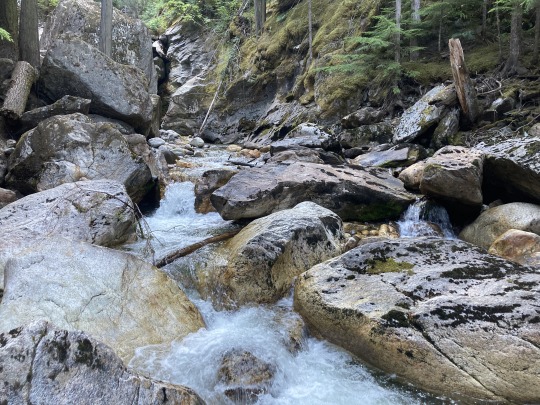
We started early today to overcast skies, but no smoke and drove to Prince George to fuel up and do some grocery shopping. Then we drove east on Hwy16 towards Jasper. The haze got thicker as we drove east. About 50k from Prince George we encountered a paving project
that went on for 70k. Unfortunately it was one of these budget paving jobs where they oil the surface and then cover it with sand and gravel, so it was very dusty and we were moving along at a slow speed. We were driving through the Rockies once again with peaks on both side of the road but it was not worth taking pictures due to the smoke from the wild fires further north.
At Tete Jaune Cache we turned south onto Hwy5 (The Yellow Head) and the traffic picked up considerably with a lot of transport trucks and tankers.
At Vailmont we could see the Thompson Ice fields to the west, but again, it was very hazy and not worth taking photos. We came upon another paving project but this one was not as bad. As we drove on the air got clearer and we could see the mountains nice and clear. Mount Lempriere and the glacier looked beautiful with blue skies behind it. We encountered more highway construction with the added attraction of the building of a pipeline.
The road was clear of construction after Blue River and it was clear sailing all the way to Kamloops.
We continued on to Sicamous where we spent the night. It was a long day of driving, but we were looking forward to getting home.
0 notes
Video

flickr
NYPD Highway Patrol Ford Taurus Police Interceptor RMP 5/29/2018
#ny#nyc#newyork#newyorkcity#richmondcounty#statenisland#travis#nypd#newyorkcitypolicedepartment#highwaypatrol#hwy#police#policecar#ford#taurus#policeinterceptor#rmp#hwy5
2 notes
·
View notes
Photo


That one time I was stuck on the road for 18+ hours because of a mudslide on highway 5 (circa late 2015′)
Made for a great photo opportunity though. All photos shot by my best friend Bellal
3 notes
·
View notes
Photo

Another hearty breakfast, this time chicken fried steak at #nancysairportcafe in #willowscalifornia good pit stop on the #hwy5 👍👍 #chickenfriedsteak #breakfast #eggs #gravy #beef #steak #diner #california (at Nancy's Airport Cafe) https://www.instagram.com/p/BsRWhdzgdNz/?utm_source=ig_tumblr_share&igshid=10d4l2m5d1c2f
#nancysairportcafe#willowscalifornia#hwy5#chickenfriedsteak#breakfast#eggs#gravy#beef#steak#diner#california
0 notes
Text
Kicking Horse Mountain Resort Day2
Kicking Horse Mountain Resort Day2
Shikaichi Ueki skiing from Vancouver: from Kelowna: from Calgary: 723km via Hwy5&1 / 8-10 hrs400km via Hwy1 / 5-6 hrs275km via Hwy1 / 3-4 hrs Kicking horse mountain Resort is the closest ski resort to the Canadian Rockies in BC. It still has BC like mountains and snow, but it feels more like being in the Rockies. This resort is in Golden, BC. It is 150km east of Revelstoke and the last…

View On WordPress
1 note
·
View note
Photo

Bad roads :: Good people There's a saying in Baja about about bad roads bringing good people. I'm hanging this week with some extremely good people and enjoying exploring some rugged 'bad roads.' Oh, and it's a real bummer that Hwy5 was paved. There goes the east side! . . . #adventure #advmode #overlanding #wndrlst #landcruiser #lc100 #lc200 #bajacruisers https://www.instagram.com/p/CHg2GePhORJ/?igshid=8kj8f9xmw8x1
2 notes
·
View notes
Video

flickr
fallow by Adrienne Johnson
0 notes
Photo

"Coquihalla Canyon Provincial Park, popularly called the Othello Tunnels is a provincial park located near Hope, British Columbia focused on the canyon of the Coquihalla River and a decommissioned railway grade, now a walking trail, leading eventually to Coquihalla Pass. Originally part of the Kettle Valley Railway, five tunnels and a series of bridges follow a relatively straight line through the gorge, which is lined with sheer, flat rock cliffs." #travelbc #exploretheworld #explorebc #hwy5 #coquihalla #coquihallacanyon #coquihallariver #explorehope #tourismhope #beautifuldestinations #beautifulbc #supernaturalbc #othellotunnels #decomissionedrailway #river #destinationbc #bcadventures #coquihallaprovincialpark #hopebc #explorecanada #mlpbycaley #iphone6s #hellobc #embracehopebc #beautifulbritishcolumbia (at Othello Tunnels)
#tourismhope#supernaturalbc#coquihallariver#hopebc#mlpbycaley#beautifulbritishcolumbia#explorebc#hellobc#coquihallaprovincialpark#explorehope#coquihalla#iphone6s#bcadventures#beautifulbc#explorecanada#decomissionedrailway#coquihallacanyon#destinationbc#hwy5#river#exploretheworld#othellotunnels#beautifuldestinations#travelbc#embracehopebc
1 note
·
View note
Photo

Flying over #hwy5 between #california #centralvalley and #sanjose @southwestair #viewfromabove #mountains #valley #farm (at California SR 152)
0 notes
Photo

#DrivingMusic #DjamelLaroussi #ArianeCap #Hwy5 #DrivingPianist #HustleMode #Art #Life #Music #International
0 notes
Photo

🤷🏻♀️When you finally get it... Just going a little over... 💃🏻 on my solo trip to #Coachella #PalmSprings late #February #Family #Friends #HWY5 #LongRoad #WorthIt #Life #iDoLike that drive 💕It was too dark when I'd seen him... but he seen me... why couldn't he have a blind spot 😂
1 note
·
View note
Photo

#15m #cortesnaeducação #educação #estudo #escola #faculdade #luta #aprenda #valorize #aprendaavalorizar https://www.instagram.com/p/Bxfrby-HwY5/?igshid=17pgkboamm91o
2 notes
·
View notes
Photo

Bom dia (em Aliados Tattoo Studio) https://www.instagram.com/p/CF4NNH-hwY5/?igshid=gihxvcg692d8
0 notes
Text
Tweeted
RT Cal_OES "RT CaltransD5: SigAlert Update: several off-ramps along #Hwy101 in #SantaBarbara are being CLOSED to assist with #ThomasFire evac orders. While southbound lanes remain open, we advise central coast motorists to use #Hwy46 or #Hwy166 to #Hwy5 for travel to So Cal.…
— Carl's Bail Bonds (@CarlsBailBonds) December 16, 2017
0 notes
Text
[Spotter Network Report] High Wind near 3 miles ENE of WALTERS, OK
"(Reported By) Jenny Brown (Time) 2017-07-01 00:56:59 UTC (Notes) Power lines down across Hwy5 east of Walters, OK. " from Spotter Network trained spotters. The Spotter Network is dedicated to bringing storm spotters, storm chasers, coordinators and public servants together in a seamless network of information. We strive to provide accurate position data of spotters and chasers for coordination/reporting which in turn provides ground truth to public servants engaged in the protection of life and property. The network is a combination of locally installed software for position and status reporting, and web based processing and mapping.
0 notes