#hike26
Explore tagged Tumblr posts
Photo

#Hike26. A nice 7-mile hike in the Sandia Foothills. 🥾 #52hikechallenge2020 (at Sandia Foothills Open Space) https://www.instagram.com/p/CFVJWlvgqoB/?igshid=12i61llp4s271
0 notes
Photo

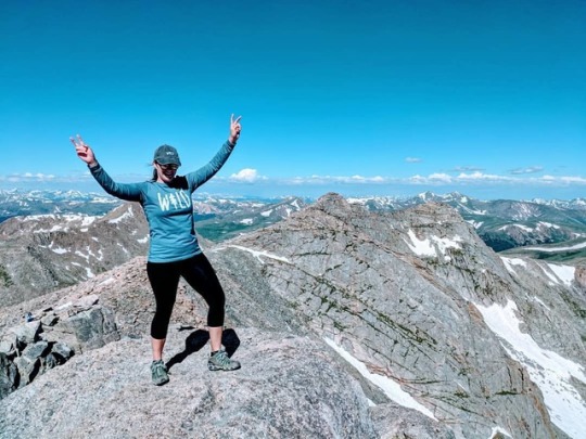
I'm so proud that this Saturday I reached my halfway point of my 52 Hike Challenge!!! 26 hikes done, and I covered 110miles doing it!!! I celebrated my 26th hike accomplishment with a 13er and 14er mountain all in one epic hike! • I was so behind when I arrived in Colorado! I was only 8 hikes in when I arrived here. That means I've completed 18 hikes in just the 10 weeks I have been in CO! • Unfortunately I have only 3 weeks left in this beautiful state! But I hope to get a couple more hikes in before we have to leave. 💛🏔🌲 📸 @mclee6254 • • • • #breathelivetravel #52hikechallenge #hike26 #52hikechallenge2019 #jackies52hikechallenge2019 #nature #naturelover #naturelovers #instanature #naturephotography #nature_perfection #outdoorwomen #girlgetoutside #girlswhohike #outdoors #theoutbound #beautyeverywhere #wildkeepers #keepnaturewild #staywild #wander #wanderlust #colorado #denvercolorado #rockymountainhigh #rockymountains #denver #coloradorockymountains #idhikethat #conqueryourmountain (at Colorado) https://www.instagram.com/p/B0ONwOyjLwH/?igshid=1qucuk4kxbanz
#breathelivetravel#52hikechallenge#hike26#52hikechallenge2019#jackies52hikechallenge2019#nature#naturelover#naturelovers#instanature#naturephotography#nature_perfection#outdoorwomen#girlgetoutside#girlswhohike#outdoors#theoutbound#beautyeverywhere#wildkeepers#keepnaturewild#staywild#wander#wanderlust#colorado#denvercolorado#rockymountainhigh#rockymountains#denver#coloradorockymountains#idhikethat#conqueryourmountain
0 notes
Photo

My go-to hike when I’m feeling lazy. Take an Evo to Grouse, hike on the Baden-Powell to Lynn Canyon. Hiking is the clouds with the singing birds for company was just what I needed. #hike26 ##52hikechallenge2019 . . . Photo📍: Unceded traditional territory of the xʷməθkʷəy̓əm (Musqueam), Skwxwú7mesh Úxwumixw (Squamish) and Səl̓ílwətaɬ (Tsleil-Waututh) First Nations. (Native Land app) #coastsalishterritory #goodtimesoutside #explorebc #instagood #natureisamazing #vancouver #britishcolumbia #beautifulbc #pacificnorthwest #pnwonderland #52hikechallenge #OptOutside #mecstaffer #queerhiker #leavenotrace #bchikes #landscape #thenorthshore #hikingadventures #hikinglife #trails #hiking #naturephotography (at Baden Powell Trail) https://www.instagram.com/p/BzqEu1IFEa_/?igshid=1p3qkuxtbglrn
#hike26#52hikechallenge2019#coastsalishterritory#goodtimesoutside#explorebc#instagood#natureisamazing#vancouver#britishcolumbia#beautifulbc#pacificnorthwest#pnwonderland#52hikechallenge#optoutside#mecstaffer#queerhiker#leavenotrace#bchikes#landscape#thenorthshore#hikingadventures#hikinglife#trails#hiking#naturephotography
0 notes
Photo

Missed a switchback and ended up off trail 😳, but still a lovely morning exploring @KennesawMountainNPS! 🚶♀️ 6.72/104.93 #hike #georgia #GirlsWhoHikeGA #girlswhohikela #52hikechallenge #hike26 (at Kennesaw Mountain National Battlefield Park)
1 note
·
View note
Photo


today i went back to conquer larch mountain. i am moving sunday and have other plans tomorrow so this was my last day for a few months to do this. i knew it was going to rain today but the forecast showed it clearing up. never trust weather forecasts in the pacific northwest, seriously.
i got up early again to catch the first gorge express bus. i did get a few more hours of sleep than the last time which was good. the bus first stopped at rooster rock state park (first photo). the water levels of the columbia river were so high that some of the stairs down were underwater. when i visited here last september there was a long stretch of sandy beach. this time it was just water.
then getting to multnomah falls, i started on trail. i knew my way so i was ready. what i didn’t expect is the downpour of rain. for most of the way up i was drenched in rain. i was just wet and cold. my phone camera kept getting wet thus the photos are not all clear. it does make them more haunting though. so for five miles i trudged through water and mud. i eventually made it to the same point i had turned around previously. the third photo is the view from there. then i kept going. at one point i saw a group with some children more than half my age. if they could get to the top with that much energy and gusto, so could i.
on the way up there were a couple moments of questioning the route but i trusted my instinct and was right. and then i made it to the top. but to be honest it was a bit anticlimactic. maybe it was because of being soaked but it didn’t feel as momentous. at the top there is basically a circle to walk around and then a paved path to sherrard’s point. there is also a trail for a crater and i could’ve added it on but with the weather choose not to. i did go to sherrard’s point. there are about one-hundred and twenty-two stairs leading to the viewpoint. if the weather was clearer it may have felt more epic. it was just miles of fog. that added to the haunting effects and vibes i felt.
then i turned around. i was ready to go down. i had gotten to the top just before half one, so it took me just under four hours. i was still in pouring rain. i just wanted to get down so i could get home to take a hot shower, not smelling as rank anymore. i have what i called “mind markers” for hikes where i make mental notes of notable things on the hike. this has the top of the multnomah falls trail, dutchman tunnel, the footbridges and trail markers for larch mountain, the rock field, and certain trees. so i was able to know where i was by what i saw around me. it’s a good way to gage where you are on a hike.
near my last two miles the rain finally let up. but i was still wet. i was thinking of the other side hikes i could’ve done because of the time. but decided to just head back. leaving sherrard’s point at half one i got back at quarter to five, so just over three hours. my phone didn’t die this time as i didn’t track my hike or spend too much time taking photos. i also kept it turned off for the bus ride there. i decided to get the five-ten bus back into the city and was able to get home around six-thirty. i have since showered and am glad to be relaxing. this hike marks 104.25 miles. i am having a more relaxed day tomorrow in the city but may hike mt. tabor tomorrow. the weather is “supposed” to be good. for my last portland hike in a few months that one feels right. and i’d be pleased to make it 1.75 miles to have an even 106 miles for being halfway through the 52 hike challenge.
so larch mountain has been completed. i recommend it, but only in good weather. the rain and the cold wasn’t as fun. and you do need to be more careful, especially going over rocks. my legs need to rest but feel good. i may take it easy for the next few weeks, not doing hikes as long or as high in elevation gain.
-n.
14 miles, elevation gain: 4,056 ft.
#52hikechallenge#52hikechallenge2017#hike26#hiking#larch mountain#columbia river gorge#multnomah falls#oregon#rooster rock
0 notes
Photo

Dig mountain marks the halfway point of my 52 hike challenge. Number 26. I can't wait to see what hikes the second half rings and seeing if I can surpass the 52 hikes and do more over the course of the year. . . . . . #optoutside #getoutstayout #memorialdayweekend #rei1440project #RoamThePlanet #Oregonexplored #dogmountain #thediscoverer #wishyouwerenorthwest #nature #liveauthentically #wildernessculture #ourplanetdaily #folkscenery #pnwonderland #thatpnwlife #staypnw #wanderlust #stayandwander #yesdiscovernature #upperleftusa #neverstopexploring #teo10k #columbiarivergorge #adventureculture #waterfalls #photooftheday #52hikechallenge #52hikechallenge2017 #hike26 @oregonexplored @discovernature @thedscrvrr @the.nw.adventure @52hikechallenge (at Dog Mountain)
#upperleftusa#getoutstayout#thatpnwlife#oregonexplored#nature#rei1440project#52hikechallenge2017#liveauthentically#staypnw#wildernessculture#photooftheday#wishyouwerenorthwest#thediscoverer#hike26#adventureculture#teo10k#neverstopexploring#folkscenery#wanderlust#ourplanetdaily#dogmountain#roamtheplanet#52hikechallenge#waterfalls#memorialdayweekend#optoutside#stayandwander#pnwonderland#yesdiscovernature#columbiarivergorge
0 notes
Text
#hike26 - Santa Fe National Forest
Date: August 4, 2018
Location: Santa Fe National Forest - Cowles, NM
Distance: 5 miles
Trails: USFS Trail #288 - Cave Creek Trail
We took off Friday night to New Mexico to go hiking and camping for the weekend. We arrived to the National Forest about 7am local time, found that our original campground was closed and moved on looking for somewhere new to go. We found an out-of-the-way campsite at Panchuela Campground, set up, and took a nap. About noon we set off on USFS Trail #288 (Cave Creek Trail) without a destination or any expectations.
The mountain views were amazing, the smell of pine so fresh, and the temperature quite tolerable. In passing, some people told us about caves and I pulled up All Trails (which had downloaded the trails near me when I had service) and found that at about 2.5 miles there were some caves to explore. The pictures don't do the caves justice, but here they are.
After feeling accomplished, and basking in the cool cave air and shade, we started the trek back, which didn't seem quite as laborious as the trek in. My favorite thing about trails is seeing them from the other side. Everything looked familiar, but different.
This is the second year we've ran away to New Mexico for a quick trip, and I think we'll do it again next year. A longer trip would be nice, but we'll see.
Takeaway:
I will always drive 10 hours to hike somewhere without NOISE. I am thankful for trails in DFW metro, but hot damn this quiet/nature was a treat.
Give yourself plenty of time if you're not used to hiking at high altitude...there's no rush.
Wear a hat, bring water, apply sunblock, and apply bug repellent. (This stuff is great)
1 note
·
View note
Photo

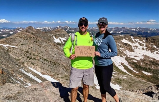
Yesterday, Matt and I conquered our first 13er and 14er Mountains. We climbed up Mt. Spalding (13,842), went down the saddle and then climbed up Mt. Evans (14,265)! 5.5 miles with a 2,000 ft elevation gain. Its was a phenomenal experience that pushed us physically. There were stunning wildflowers everywhere. Chilly temperatures with some snow, which was an amazing thing experience on July 20th! The views were incredible! We also got to see some cute mountain goats. An experience we will never forget! • • • • #breathelivetravel #52hikechallenge #hike26 #52hikechallenge2019 #jackies52hikechallenge2019 #nature #naturelover #instanature #naturephotography #outdoorwomen #girlgetoutside #girlswhohike #outdoors #coupleswhohike #travelingcouple #travelot #travelrt #beautyeverywhere #keepnaturewild #staywild #wander #wanderlust #colorado #denvercolorado #rockymountainhigh #rockymountains #denver #coloradorockymountains #mtevans #mountainlife (at Mount Evans) https://www.instagram.com/p/B0Me1WwDRP0/?igshid=kv4hfkth1qbl
#breathelivetravel#52hikechallenge#hike26#52hikechallenge2019#jackies52hikechallenge2019#nature#naturelover#instanature#naturephotography#outdoorwomen#girlgetoutside#girlswhohike#outdoors#coupleswhohike#travelingcouple#travelot#travelrt#beautyeverywhere#keepnaturewild#staywild#wander#wanderlust#colorado#denvercolorado#rockymountainhigh#rockymountains#denver#coloradorockymountains#mtevans#mountainlife
0 notes
Photo

#hike26 Ten K slow hike on the Norvan Falls Trail. I guess there is more work to do before I feel steady on my knee without what I call my cyborg attachment (knee brace). #gottadothoseexercises . . . #coastsalishterritory #mecstaffer #goodtimesoutside #explorebc #instagood #natureisamazing #vancouver #britishcolumbia #beautifulbc #pacificnorthwest #pnwonderland #nature #outdoors #bchikes #landscape #mountains #sky #hikingadventures #view #forest #hikinglife #trails #hiking #hike #naturephotography (at Norvan Creek)
#landscape#beautifulbc#vancouver#gottadothoseexercises#pacificnorthwest#hiking#trails#outdoors#coastsalishterritory#instagood#hike#bchikes#mecstaffer#forest#nature#pnwonderland#naturephotography#explorebc#sky#hike26#view#natureisamazing#hikingadventures#mountains#goodtimesoutside#britishcolumbia#hikinglife
0 notes