#fort meigs historic site
Explore tagged Tumblr posts
Text

I'm so obsessed with Fort Meigs, and I wonder how many of my mutuals know how it's pronounced.
It's "Meggs" (written phonetically), rhymes with legs. That's how (most) War of 1812 historians and enthusiasts say it, and that's how the locals pronounce it. I remember one video from a Kentucky historical society pronounced it like "Miggs," but maybe that's the Kentucky accent.
Head Quarters Camp Meigs April 22nd 1813
Genl Orders
The Guards will in future when relieved be conducted to the outside of the Camp and under the direction of the Officer of the day will discharge the loads in their Guns at a Mark— The best shot will receive a quart of whiskey the second best a pint upon the Order of the Officer of the day—
— Orderly Book of Cushing's Company, Fort Meigs (Ed. by Harlow Lindsey, The Ohio Historical Society)
#war of 1812#fort meigs#military history#us history#learning that william henry harrison was also a whiskey distiller at one point#well no wonder he loved whiskey-based incentives#alcohol#1810s#the map is from the 100 year anniversary#can't wait for opening weekend at fort meigs historic site!!!!!!!#maps#us army#old northwest
12 notes
·
View notes
Video
Found Slide by Thomas Hawk
0 notes
Photo


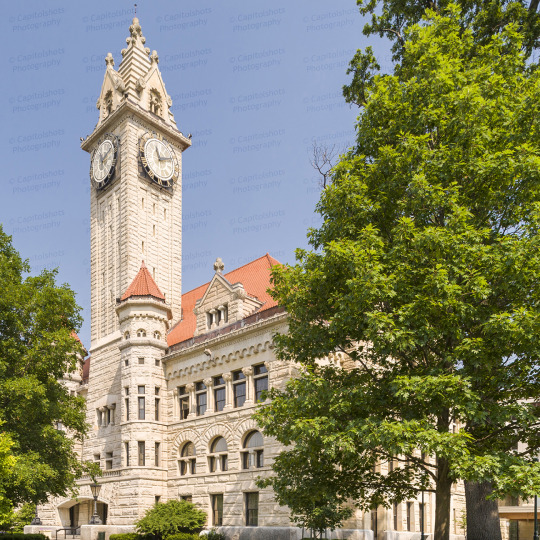

Wood County Courthouse
1 Court House Square
Bowling Green, OH 43402
The Wood County Courthouse and Jail, located in Bowling Green, Ohio, is Wood County's third courthouse. It was built after citizens decided to move the county seat from Perrysburg to Bowling Green. Ground was broken on November 28, 1893, and the cornerstone was laid on July 4, 1894. Joseph W. Yost and Frank L. Packard from the architectural firm of Yost & Packard of Columbus designed the courthouse and construction was overseen by T.B. Townsend of Youngstown. The winning tender for the project was $153,803 and the final construction costs totaled $255,746. The County Commissioners took possession of the new building on August 31, 1896, and the new Common Pleas Courtroom was dedicated on September 7, 1896.
Sandstone from Amherst, Ohio, granite from Vermont, and marble from Italy were used in the construction of the courthouse. Architecturally, it is Richardsonian Romanesque in design with architectural sculpting throughout the building done by Whyte and Priest of Dayton, Ohio. To facilitate construction, a temporary railroad along Pike Street was established to the construction site. Ornate stained glass panels cover much of the ceiling on the third floor and are visible from ground level due to the large open staircase which ascends through the middle of the second floor. The staircase consists of polished marble steps with brass railings.
The clock tower rises to a height of 195 feet. At the time of its construction, the clock hands were the second largest in America spanning 16 feet in diameter. They were exceeded only by the hands on the clock of the Chronicle newspaper building in San Francisco which were 16.5 feet in diameter. The clock was made by the E. Howard & Co. at a cost of $3000. The clock tower bells weigh 2,000 lb (910 kg).
Murals decorate the east and west walls of the third floor. The murals were painted by I. M. Taylor, who was the mayor of Bowling Green from 1911 to 1920. The east wall depicts Fort Meigs, a vital outpost in the War of 1812, and the west wall depicts a train passing through oil derricks in southern Wood County, a major producer of oil in the late 19th century.
A major restoration of the interior of the courthouse was undertaken in 1980, and a restoration of the exterior of the building was completed in 2002. President William Howard Taft held a rally at the courthouse in 1912. Jimmy Hoffa visited the courthouse on September 25, 1937 to get a marriage license, and married his wife in Bowling Green the same day. President Ronald Reagan delivered a speech at the courthouse on October 19, 1988 to promote the candidacy of George H. W. Bush. The building, located at 1 Courthouse Square in the county seat of Bowling Green, is still in use and today houses the Wood County Court of Common Pleas and its probate and domestic relations divisions.
There are two common pleas courtrooms and accompanying judicial offices located on the third floor as well as a jury assembly room, holding cell and conference rooms. A probate courtroom and judicial offices are located on the second floor, as is the Clerk of Courts Office. The first floor houses court security, court administration and a domestic relations courtroom with magistrates' offices and conference rooms. A five-story office building adjoining the courthouse contains a third common pleas courtroom and judicial offices as well as other county offices including the auditor, treasurer, engineer, commissioners, prosecutor, adult probation, building inspection and board of elections. A glass-enclosed atrium joining the courthouse and office building was completed in 2004. At that time existing entrances and exits to both buildings were closed and the atrium became the only public entrance to either building. It is staffed by court security who monitor people entering the buildings.
The clock tower is still in use. The original chimes are in working order and ring the hour, every hour, by denoting one chime per hour. All four clockfaces are quite remarkable, with two layers of Roman numerals. The inner layer closest to the center is golden and can be viewed easily when in shade. The outer ring on numerals is painted black iron which is easily readable when in direct sunlight. The tower also contains a box designed for use by nesting falcons. Construction of the old Wood County Jail, located next to the courthouse, was begun on May 21, 1901, and completed in 1902 at a cost of $49,000. The Fremont firm of Fronizer and Andrews constructed the building, which continued in use as the county jail until 1990.
Wood County is named after Maj. Eleazer D. Wood, an American Army officer in the War of 1812. Wood built Fort Meigs, which was located near Perrysburg, in 1813. This was used by American soldiers during the war to repel British attacks in the spring and summer of 1813. The courthouse was placed on the National Register of Historic Places in 1974.
2 notes
·
View notes
Text
Tomorrow—or today, depending on your time zone—is the First of July: the start of Fiscal Year 2025, Canada Day, AND my birthday.
I'm going to be at work for a white-knuckle week of being very short-staffed as I prepare for the Big Fucking Audit that will almost certainly be July 8th (but is unannounced).
In a better world I would be at Fort Malden in Amherstburg, celebrating Canada Day and my birthday at a War of 1812 historic site—it's only an hour and a half away!! I'm so close I could weep!
But I don't have a passport, and I definitely don't have a long weekend. I have the 4th of July off, and I hope to have a good time at Fort Meigs, but it doesn't get any less nerve-wracking.
#shaun talks#THERE'S ALWAYS NEXT YEAR#i will be glad when the big fucking audit is over#happy canada day to my canadian mutuals and followers
45 notes
·
View notes
Text
"The past is a foreign country; they do things differently there," is the quote from a mid-20th century novel. The War of 1812 took place decades before the military funeral song "Taps" was written and popularized during the US Civil War.
Alfred Lorrain describes scores of men dying from disease at Fort Meigs in 1812-1813, which was the top killer of soldiers throughout the Napoleonic era:
They died daily. The mournful air of "Roslin Castle" became the prevailing music of the day, while the sharp rifle-cracks of the platoon told how many were borne to their long home. A deadly homesickness overwhelmed our troops, and we believe a repentance of war was kindled in every bosom, from the highest to the lowest.
— Alfred M. Lorrain, The Helm, the Sword, and the Cross.
youtube
It's a haunting melody (and new favorite song). When I was at Fort Meigs historic site earlier in the month there was also a fiddle player in period costume, which was wonderful.
#war of 1812#military history#military funeral#roslin castle#alfred lorrain#fort meigs#ohio#1810s#us army#music#folk music#lorrain's memoir is itself 'a repentance of war'#us history
123 notes
·
View notes
Text


Some pictures of the "Garrison Ghost Walk" tour from Fort Meigs' Facebook page. I'm going to the last tour of the season tonight (with a later adults only group), and I doubt my phone camera will take good pictures after dark.
This will be my first ghost tour at Fort Meigs, and I'm curious about what kind of stories they'll share—some legend or myth from 1813, or paranormal experiences of the historical site workers and volunteers?
I think a lot about how the present-day reconstruction of Fort Meigs does not look much like the armed camp in its heyday (when it was a sea of mud and filth and not a grassy park). But the human remains of countless individuals are present throughout the site. I wouldn't say that it feels haunted, but there is definitely a heaviness in the atmosphere.
#war of 1812#fort meigs#halloween#garrison ghost walk#military history#napoleonic#living history#historical reenactment#we're leaving shortly for this and i'm very excited!#shaun talks
19 notes
·
View notes
Text
I have been obsessed with Fort Meigs recently and the Ohio campaigns of the War of 1812, so this news article hit differently. The Ohio History Connection (the same organisation behind the Fort Meigs historic site) is trying to preserve a historic and culturally significant Indigenous earthworks from the golf course that has used it since 1910. The fact that this callous use of an ancient astronomy and ritual calendar site has been allowed to go on also reflects the violent removal of the Shawnee people who by all rights should have been there protecting and using the site. Imagine if they made Stonehenge a golf course!
This is all related to the War of 1812 and campaigns against the Shawnee, Potawatomi and Miami Nations. I have been thinking a lot about this since Indigenous Peoples' Day is Monday, and I have been thinking of writing up something with a predictable War of 1812 focus (there is a lot of material). It just goes to show how much the issues of the War of 1812 continue to affect the present day.
#war of 1812#indigenous#shawnee#ohio#us history#hopewell ceremonial earthworks#world heritage site#settler colonialism
55 notes
·
View notes
Text

A marker commemorating the 41st Regiment of Foot at Fort Miamis Historic Site. It was placed at the 200th anniversary of the Siege of Fort Meigs, and I see that the 41st Regiment of Foot military living history group (MLHG) was one of the organizations behind it: the same people who re-enact the 41st Regiment at Fort George and Fort Meigs, among other sites.
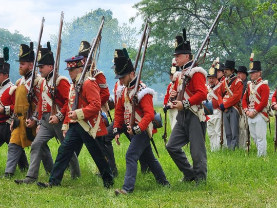
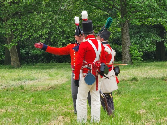
Although they were enemy combatants in 1813, I appreciated seeing their sacrifice remembered. The marker also commemorates Private Patrick Russell of the 41st Regiment of Foot, who died attempting to protect American prisoners of war at Fort Miamis.
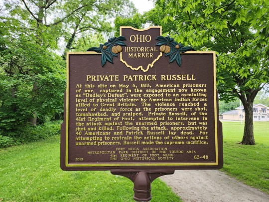
In the published narrative of Shadrach Byfield, another enlisted man from the 41st Regiment of Foot, Russell is described as "an old and excellent soldier."
#fort miamis#war of 1812#military history#redcoats#british army#41st regiment of foot#ohio#maumee#shadrach byfield#patrick russell#historical marker#living history#historical reenactors#historical reenactment#fort meigs#napoleonic#1810s#1813
16 notes
·
View notes
Note
Is there anything about your new location (the terrain, the local culture, the physical sites, etc) that has given you a new perspective on regional events of the War of 1812?
This a wonderful ask, thank you! I have been mulling over how to answer it all day! This ended up getting so long I put it behind a cut (I HAVE A LOT OF FEELINGS ABOUT THIS).
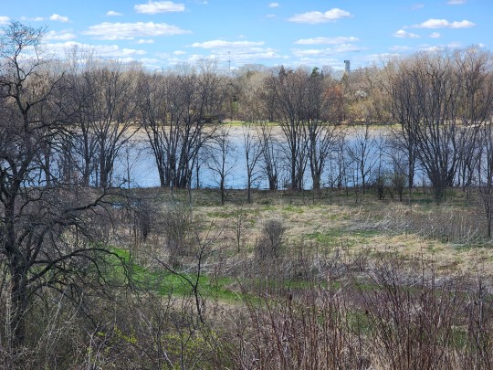
The Maumee River, as seen from Fort Meigs Historic Site.
One thing new in my life is a heightened awareness of important rivers facilitating the movement of trade, supplies, and settlement. Particularly in the Old Northwest/current Midwest of the USA: regions that I grew up perceiving as a land-locked "flyover country."
Like, to give one example, I had a vague idea that there was a city called Fort Wayne, Indiana, but I thought it was just in the middle of a cornfield for no reason(?). But actually it's at the confluence of the St. Joseph, St. Marys, and Maumee Rivers, leading to the Great Lakes! The strategically important location is why General Anthony Wayne—that guy again—built the original fortification in 1794. I am downriver of all of this, connected to many inland waterways.
I also have a keen sense of living in the Great Black Swamp, despite how dramatically the land has been transformed by deforestation and drainage. There are the terrifying drainage ditches everywhere (the locals seem less perturbed by them), and many other signs of the natural state of the terrain—the swamp is just barely at bay. My coworkers have said "Black Swamp" unprompted in our conversations; I've seen it mentioned in local Facebook groups talking about the need for back-up sump pumps. The idea that people of northwest Ohio have no sense of history and are unaware of the Great Black Swamp isn't true at all.
I look at the pools of water that form in every hollow and think of the words of Alfred Lorrain, marching to Fort Meigs:
We had frequently to pass through what was called, in the provincialism of the frontiers, "swales"—standing ponds—through which the troops and packhorses which had preceded us had made a trail of shattered ice. Those swales were often a quarter of a mile long. They were, moreover, very unequal in their soundings. In common they were not more than half-leg deep; but sometimes, at a moment when we were not expecting it, we suddenly sank down to our cartridge-boxes.
Swale is a new word in my vocabulary, and now I see them everywhere!
Culturally, I think there is a great appreciation of history here: a very positive difference from the Chicagoland area. Even if the average local is probably not deeply into it, they have a consciousness of major historical events that have shaped their region and take pride in it. It's a lot more like New England that way.
Because of my focus on the War of 1812, I notice the absence of Indigenous people and voices—absent from historical accounts and from the demographics of Perrysburg and its environs today. I can't single out Ohio as being a uniquely violent settler-colonial state when this is ALL of the United States; but it hits different when I have this much greater familiarity with who was forcibly removed from this land, and how. The same US military leaders who fought in the War of 1812 were behind the (very much related) campaign for the removal of Native Americans from newly acquired territories, including the infamous Trail of Tears.
Once again, it's probably hypocritical for me to notice this so much, when I literally grew up on Wampanoag land where King Philip's War was fought, but here I am. Suddenly aware of General Wayne's name on everything, etc.
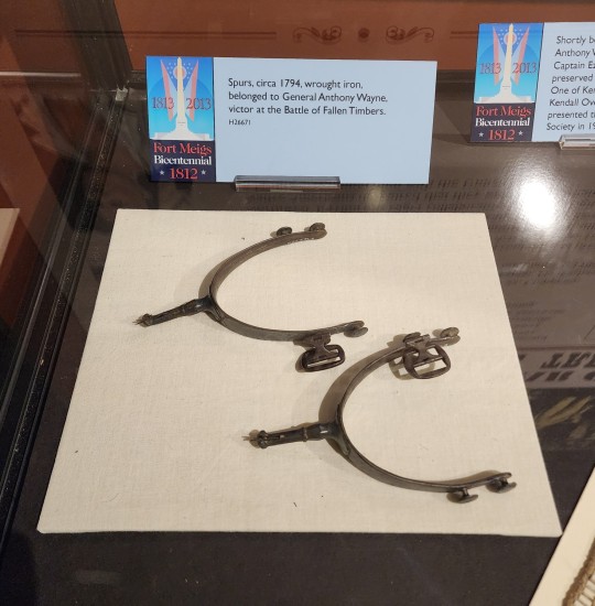
General Wayne's spurs in the Fort Meigs Museum. Not pictured: the can of Maumee Bay Brewing Co. Fallen Timbers Ale that I am currently drinking.
I haven't had the chance to explore physical sites with historical significance beyond Fort Meigs and Fallen Timbers. I know I will get to the ruins of Fort Miamis soon, and I really want to explore a lot of wetlands in local parks and nature preserves (that will double as birdwatching excursions). I am always thinking about what this place looked like 200 years ago, and what I can see today that might still look familiar to a person from that time.
I had a great trip to the National Museum of the Great Lakes today, which is closer than I thought! Local maritime museums are also on my agenda, even if they're not specifically War of 1812-related.
#asks#shaun talks#ohio posting#i could add three or four more paragraphs to any given paragraph here#you activated my trap card
22 notes
·
View notes
Text

I still haven't found any fish hooks in the Fort Meigs Historic Site Museum, but I did see these fish gigs! They would be used for spearing fish.
Captain Daniel Lewis Cushing of the 2nd U.S. Artillery also mentions the use of a seine net by the soldiers at Fort Meigs in 1813:
Tuesday, June 1st.—Nothing new this day except drawing seine; they caught a large quantity of fish. (Cushing's Diary)
There are multiple accounts of the incredible bounty of fish in the Maumee River at this time, and how easy it was to catch them. Sadly not the state of the Maumee in the 21st century, although things are improving.
#fort meigs#war of 1812#maumee river#ohio#1810s#daniel lewis cushing#fishing#fish gigs#artifacts#i always feel wistful when i read about the bounty of the river 200+ years ago#it's not clean today altho you can fish in it still
9 notes
·
View notes
Photo


Harrison House
Or Jacob Overdier House and Lucas Sullivant Land Office
Franklinton Historical Society
570 West Broad Street
Columbus; OH
The Harrison House was most likely built in 1807, when Thomas Jefferson was 3rd President of the United States, by Jacob Oberdier, but the lack of documentation, drawings and photographs may put that date in dispute. The Harrison House, a Federal-style brick rectangular two-story building, was one of only twelve brick homes built in early Franklinton, and is one of the few remaining original structures of Franklinton still standing. General William Henry Harrison, who later became the 9th President of the United States, is said to have used the home in 1813 and 1814 as a headquarters for the Northwest Army during the War of 1812. While he was in Franklinton, General Harrison was actively working to recapture Fort Detroit, to fortify the frontier, to build and supply Fort Meigs (near Perrysburg), and to thwart three invasions of Ohio by the British and their American Indian allies. Harrison, of course, is famous for being President of the United States for 31 days and then dying, having caught pneumonia three weeks into his presidency. He has the dubious honor of owning two American history superlatives: serving the shortest presidential tenure and giving the longest inaugural address. At two hours long, his inaugural address accounted for approximately .27% of his entire presidency.
The records go back to the October 28, 1796, Survey Entry #1393. Lucas Sullivant purchased the 1000-acres of this survey, and it became the footprint of Franklinton in 1797. Eighteen individuals/families have owned the Harrison House. Michael Sullivant, Lucas’ second son, was an owner, along with four women—Agnes “Nancy” Culbertson Parks, Margaret Stirling, Olive Spencer, and Mary Kuhn. William Henry Harrison was never an owner. Later during the Civil War, confederate spy A.J. Marlowe lived in the home, reporting his findings from Camp Chase to the south. Seventeen individuals, overall, have owned the house, the longest residents being the Kuhn Family who resided in the home from 1863 to 1973. The Harrison House was registered as a National Historic Place in 1972, but was almost leveled to make way for a parking lot in 1975. During the campaign to save the house in the early 1970s, preservationists touted it as General Harrison’s headquarters during the War of 1812. Other owners of the house include the 1975 Fran Ryan preservation coalition. The house was one of those rare buildings that survived the pavement, and in 1980, was purchased by the City of Columbus. The house was renovated during 1980-1985 to reflect the time when Franklinton served as one of the headquarter sites of General William Henry Harrison, commander of the U.S. Army of the North West, during the War of 1812.
For several years, the Harrison House was leased through the city to the Franklin County Historical and Genealogical Society. The Franklin County Genealogical and Historical Society began as just a genealogical society receiving its charter in November 1970. The Society found a home in 1985 at the 200 year-old Harrison House in historic Franklinton where it remained for 25 years before moving to the Grove City Area Visitors and Convention Bureau. The Lucas Sullivant Land Office, built in 1822, is directly behind the house. It originally sat on Gay St. but was moved here in the 1980’s to avoid demolition. It was from this building Franklinton founder Lucas Sullivant sold land on both sides of the river. The Franklinton Historical Society (FHS) has long held a dream of having a museum in which they can interpret the unique stories of Franklinton from its inception through the present and is raising funds to provide repairs of these buildings, give tours, and have community events. FHS is united in anticipating an agreement with the City going forward so they can begin their role as care-taker to protect these important Franklinton jewels. The plan for this building, as well as the Lucas Sullivant Land Office, is to serve as publicly accessible museums—secure spaces in which to display exhibits and artifacts and tell the stories that explain Franklinton’s importance in the foundational history of the state, its capital city, and the nation. The Franklinton Historical Society is a group of dedicated people who have a strong sense of pride in the area’s historic past and its growth. The Harrison House and Sullivant Land Office are a key component of allowing the Society to educate and share information about Franklinton’s multi-faceted history.
0 notes
Photo


Fort Miamis State Memorial Corey Street Maumee, Ohio The British Fort Miamis located on the Maumee River several miles away from Fallen Timbers off River Road, played a role in the Battle of Fallen Timbers and, later, the War of 1812. Before Fort Miamis was built the site was used as a French trading post in the 1600s. Before that an archeology study of the site revealed that it was also a site used by the Late Woodland mound builders. Fort Miamis was an earthwork fortification located on the west side of the Maumee River and just south of Toledo. Designed and built by Royal Engineers, Fort Miamis consisted of 4 diamond shape earthen walls called bastions. The British dug a 24' deep trench around the fort and lined it with rows of stakes to slow an enemy's assault of the fort. The British also placed 14 cannon in the fort to thwart any attackers. The fort was designed to defend the land and water routes to Detroit against American forces under General Anthony Wayne. The British, with the support of the Indian Confederation, had constructed Fort Miamis in spring 1794 to hold the Maumee Valley and stop Wayne's advances towards Detroit. It also afforded the British additional means to solidify Indian support against the U.S. settlers moving into the Ohio Territory. Late in 1794 General Wayne and his troops marched northward toward Fort Miami from Fort Greenville. Just south of the fort, ambushed by the Native Americans and a small party of Canadian militia, he ordered a charge and dispersed his adversaries in the Battle of Fallen Timbers. The Native Americans fled to Fort Miami, but despite the promise from the British that the fort would offer protection to the Indians, the commander of the fort shut them out, and they instead had to proceed to the mouth of Swan Creek. Beaten and disillusioned, the Native Americans dispersed and one year later their tribal elders gathered at Fort Greenville to negotiate with Wayne. After the battle General Wayne felt that Fort Miamis was too strong to be forced, and he returned to Roche de Bout. In 1796, under the terms of Jay's Treaty (1794), the British abandoned Fort Miami. Wayne occupied and garrisoned it, but about 1799 U.S. troops abandoned it. The British again occupied the site during the War of 1812, which at the time was opposite the American Fort Meigs. During the War of 1812 Tecumseh, the Shawnee chief, and British officials maintained headquarters at the fort, from where they moved against Gen. William Henry Harrison at Fort Meigs. In 1942 several Ohio civic and patriotic organizations acquired a part of the site of the old fort. Nothing remained of the original structure except parts of the earthworks. In 1953 the Ohio State Archaeological and Historical Society conducted preliminary excavations, and in 1957 the Historical Society of Northwestern Ohio placed a marker at the site, which remains undeveloped. In 1975, the site of the fort was added to the National Register of Historic Places. The site of the fort was incorporated into Fallen Timbers Battlefield and Fort Miamis National Historic Site in 1999, under Public Law 106-164. The site is managed by the Metropolitan Park District of the Toledo Area (Metroparks), in partnership with the Ohio Historical Society, and is an "affiliated unit" of the National Park System. Fort Miamis is in a Maumee residential area approximately 5 miles east of the battlefield and memorial. The south side of the fort falls off steeply to the Maumee River. The fort was previously owned and managed by the City of Maumee, but on November 7, 2005, the City Council voted to return ownership to Metroparks of the Toledo Area. The park is open, and much of the earthworks used to create the fort are still visible. Archeological remains at the fort are available for future study and interpretation. Today, some of the trenches, traces of the earthen walls and one of the bastions are all that remain visible. The fort structure no longer stands, and the site reverted to agricultural and, later, public park use. Today it sits as a small enclave in residential development.
0 notes