#earthquake philippines
Explore tagged Tumblr posts
Text
Davao del Sur Rocked by Magnitude 5 Quake
A magnitude 5 earthquake occurred Tuesday morning in Davao del Sur according to the report by the Philippine Institute of Volcanology and Seismology (Phivolcs). The tremor hit the municipality of Matanao at 9:42 a.m. with its epicenter located some 5 kilometers from the said municipality. It had a depth of focus of 15 kilometers and was tectonic in origin. The areas below reported the…
#Davao del Sur#davao earthquake#earthquake monitor#earthquake philippines#earthquakePH#LindolPH#mindanao earthquake#news philippines#Phivolcs
0 notes
Text
फिलीपींस में आया 6.8 की तीव्रता का भूकंप, सुनामी का कोई खतरा नहीं; जानें अब कैसे है हालात
Philippines Earthquake: फिलीपींस के मिंडानाओ द्वीप के पूर्वी तट पर शनिवार को भूकंप के झटके महसूस किए गए। भूकंप की तीव्रता रिक्टर स्केल पर 6.8 थी। जर्मन रिसर्च सेंटर फॉर जियोसाइंसेज (जीएफजेड) ने बताया कि भूकंप का केन्द्र जमीन से 10 किमी (6.21 मील) की गहराई पर था। अमेरिकी भूवैज्ञानिक सर्वेक्षण के अनुसार भूकंप की तीव्रता 6.8 थी। अमेरिकी राष्ट्रीय सुनामी चेतावनी केंद्र ने कहा कि भूकंप से सुनामी का…
0 notes
Text

A Catholic nun joins others holding candles while offering prayers for the country and also victims of the recent earthquake in Myanmar, after a religious procession in observance of Lent, in Quezon City, Philippines, Friday, April 4, 2025. (AP Photo/Aaron Favila)
#religion#christianity#catholicism#christians#nuns#people#lent#earthquake#myanmar earthquake#natural disaster#philippines#divinum-pacis
13 notes
·
View notes
Text
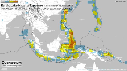
INCREASED (yellow): Seram, Kepulauan Batu-Kepulauan Mentawai, Sumatra, Sunda Strait, Java, Bali, Sumbawa, Timor, Flores, Kepulauan Tanimbar, Northern Philippines, Makassar Strait, Papua, Eastern Papua New Guinea, Ceram Sea.
HIGH (orange): Molucca Sea, Kepulauan Sanghe - Kepulauan Talaud, Minahasa, Sulawesi, Halmahera, Kepulauan Barat Daya - Kepulauan Babar, Mindanao and Leyte (Philippines), New Britain region (P.N.G), S Sumatra, Banda Sea, Kepulauan Alor.
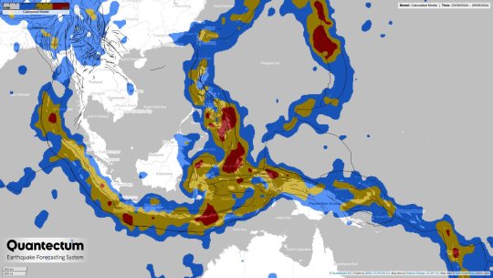
During the week, the HIGHEST TECTONIC TRACTIONS will be present in: · Luzon, Leyte and Mindanao, Philippines · Kepulauan Talaud · Minahasa, Sulawesi · Sumbawa · Flores Sea · Nicobar Islands · Bali Region · Halamera · Molucca Sea Regions that will be the most tectonically unstable are: · Sumbawa, Sunda Strait, Kepulauan Tanimbar, Kepulauan Talaud, Halamera · Kepulauan Alor Philippines – northern, central, southern, New Britain Region (Papua), Papua New Guinea.
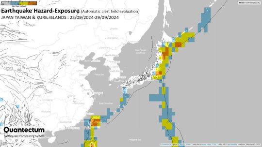
MODERATE: Kyushu, Shikoku, SE Ryukyu, Izu Islands. INCREASED: Kuril Islands, Volcano, Bonin Is, east of Kuril Islands. HIGH: off east coast of Honshu, near east and south coasts of Honshu, Hokkaido, Taiwan.
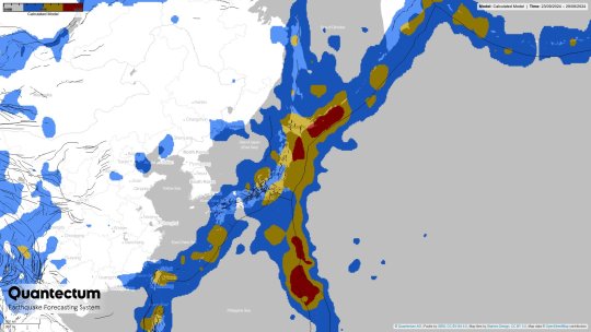
Due to the passage of strongly active tectonic waves, the active traction will be the highest along east Honshu, Hokkaido, Izu Islands, Kuril Islands, Taiwan, Volcano, Bonin Islands, southeast Ryukyu, and off east coast of Honshu.
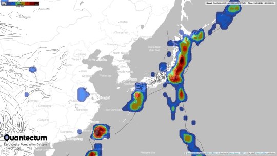
According to instability alert field, the most tectonically unstable regions will be Taiwan, the Kuril Islands, near east and west coasts of Honshu and Hokkaido, due to the strong local Time-synchronizations along the regional fault system.
Courtesy of Quantectum - Earthquake Forecasting System
#地震#earthquake#earthquakes#日本#indonesia#philippines#papua new guinea#taiwan#seismology#geophysics#global#worldwide
4 notes
·
View notes
Text
🇹🇼 🚨
MASSIVE EARTHQUAKE ROCKS TAIWAN KILLING SEVEN AND WOUNDING DOZENS
📹 Scenes from a massive 7.4 magnitude earthquake that rocked Taiwan on Tuesday night, killing at least seven people, or as many as nine according to other reports, and wounding as many as 800 others.
According to the United States Geological Survey (USGS), the earthquake, which struck shortly before midnight on Tuesday, caused extensive landslides and liquifaction of the ground, destroyed several buildings, and prompted Japan, Taiwan and the Philippines to issue tsunami warnings, which were later lifted.
The earthquake was felt from the Taiwanese capital of Taipei, to southern Japan, to as far away as eastern China and the Philippines.
The earthquake was among the strongest of its kind to hit Taiwan in over 25 years, with the worst damage being reported in the eastern city of Hualien, as well as the surrounding mountain countryside.
#source1
#source2
#videosource
@WorkerSolidarityNews
#taiwan#taiwan earthquake#taiwan news#asia#asia news#philippines#japan#china#earthquake#damage#destruction#natural disasters#natural disaster#politics#news#geopolitics#world news#global news#international news#breaking news#current events
7 notes
·
View notes
Text
“I don’t want it to happen.”
It’s just that my Mom suddenly got a message from her work’s Group chat, warning of the possible earthquake coming here. The mortifying thing about this earthquake is that it’s as strong as Japan’s 7.5 earthquake, so is the fact that this article was just published last one or two months ago.
I already feel what I don’t want to feel, I don’t want to lose everything. I’ve been “resilient” enough in life, and my faith just been too questionable ever since I never thought purely/“wholeheartedly” anymore. I shouldn’t be doubting, I shouldn’t be questioning, please just pray…
2 notes
·
View notes
Photo

7.6-magnitude earthquake strikes off the Philippines and a tsunami warning is issued - ABC News
5 notes
·
View notes
Text
Taiwan Invasion Threatens Philippines
by Cliff Potts, Editor-in-Chief, WPS News Baybay City | April 2, 2025 — As the situation in the West Philippine Sea grows tense, the Philippines finds itself in a precarious position. For years, the government’s response to China’s increasing assertiveness has been criticized as inadequate. Filipinos have watched as Chinese forces expanded their presence in the area, often with little action…
#china#earthquakes#military exercises#Overseas Filipino Workers#Philippines#taiwan#West Philippine Sea
0 notes
Text
More Construction Standards in the Philippines
Photo by Elianna Gill This article looks at More Construction Standards in the Philippines. Previously we looked at how electrical and plumbing systems as standard were embedded in the concrete walls. Before I give my opinion on how I will have things done. I want to look at a few other construction standards you will find in the Philippines. Vlogging I have just watched a YouTube video by an…
#Building codes in the Philippines#Building design standards Philippines#Building inspection Philippines#Building materials standards Philippines#Building permit requirements Philippines#Building Safety Philippines#Commercial building standards Philippines#Construction quality control Philippines#Construction standards Philippines#Earthquake building standards Philippines#Energy efficiency standards Philippines#Fire safety regulations Philippines#Green building standards Philippines#Philippine architectural standards#Philippine building code compliance#Philippine construction regulations#Philippines building standards#Residential building codes Philippines#Structural standards Philippines#Sustainable building practices Philippines
0 notes
Text
Muntinlupa City Government to prohibit all new construction on earthquake fault zones
The City Government of Muntinlupa just announced that all new construction located on earthquake fault zones will be prohibited and already the implementing rules and regulations (IRR) of City Ordinance 2024-174 are being drafted, according to a Manila Bulletin news report. To put things in perspective, posted below is an excerpt from the Manila Bulletin news report. Some parts in boldface… The…

View On WordPress
#Alabang#Alabang blog#Blog#blogger#blogging#Carlo Carrasco#City Government of Muntinlupa#City of Muntinlupa#construction#disaster#diversity#earthquake#earthquake fault zones#geek#governance#Inclusion#infrastructure#journalism#Manila Bulletin#Metro Manila#Muntinlupa#Muntinlupa City#National Capital Region (NCR)#natural disasters#NCR#news#Philippines#politics#public service#Ruffy Biazon
0 notes
Text
Phivolcs: Magnitude 4.3 earthquake tumama sa lugar ng Magsaysay at Davao del Sur
Isang malakas na lindol na umabot sa 4.3 at tumama sa Magsaysay, Davao del Sur kaninang umaga sa oras na 9:09, ngayong araw ng Linggo.
Mula sa Kidapawan City at Cotabato City naramdaman at umabot sa Intensity II, ayon sa Philippine Institute of Volcanology and Seismology (Phivolcs).
Ang mga lugar na naramdaman ng lindol ang mga sumusunod:
Intensity III: Davao del Sur, Magsaysay at City of Digos.
Intensity II: Saranggani, Malungon
Intensity I: South Cotabato at Banga
#Davao del Sur#Magnitude 4.3 earthquake#Magsaysay#Philippine Institute of Volcanology and Seismology (Phivolcs)#Phivolcs#Top News#Trending#Viral
0 notes
Text
Eastern Samar Rocked by Magnitude 5.3 Quake
A magnitude 5.3 hit Eastern Samar yesterday evening at around 8:50 p.m. Philippine Institute of Volcanology and Seismology (PHIVOLCS) determined the quake to be tectonic in origin. The tremor was recorded some 32 kilometers northeast of Hernani in Eastern Samar. It had a dept of 10 kilometers. The following intensities have been recorded in some areas: Intensity V – Hernani, Maydolong,…
#earthquake monitor#earthquake philippines#earthquakePH#Eastern Samar#LindolPH#news philippines#Phivolcs#Visayas earthquake#visayas news
0 notes
Text
फिलीपींस में लगे 4.1 की तीव्रता के भूकंप के झटके, जान माल की नहीं हुआ नुकसान
Earthquake in Philippines: साल 2025 में भी भूकंप आना लगातार जारी है। आज सुबह फिलीपींस देश की धरती भूकंप के झटकों से कांप गई। जर्मन रिसर्च सेंटर फॉर जियोसाइंसेज (GFZ) ने भूकंप की पुष्टि की और बताया कि आज सुबह स्थानीय समयानुसार करीब सवा 8 बजे भूकंप के झटके लोगों ने महसूस किए। इस भूकंप की तीव्रता रिक्टर स्केल पर 4.1 मापी गई। हालांकि इस भूकंप से किसी तरह के जान माल का नुकसान नहीं हुआ, लेकिन झटके…
0 notes
Text
How is our country still standing

instagram
0 notes
Photo


(via Update: 12/11/23)
#地震#earthquakes#earthquake#global#worldwide#california#philippines#japan#indonesia#chile#peru#argentina#bolivia
3 notes
·
View notes
Video
youtube
Not For The Faint Of Heart: Powerful 7.6 Earthquake In Mindanao, Philipp...
0 notes