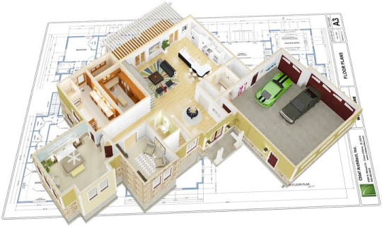
#application of bim in construction
Explore tagged Tumblr posts
Visit Tumblr Blog
Explore Tumblr blogs with no restrictions, modern design and the best experience.
Last Seen Tumblr Blogs


Fun Fact
Users from the US are the majority of Tumblr visitors.
Text
BIM Applications in Construction: Revolutionizing the Industry with BIM Software Development

Introduction
The construction industry has undergone a significant transformation in recent years, thanks to the adoption of Building Information Modeling (BIM) technology. BIM has emerged as a game-changer, revolutionizing the way construction projects are planned, designed, executed, and managed. In this blog, we will explore the various applications of BIM in construction and the role of BIM software development in driving this transformation.
Understanding Building Information Modeling (BIM)
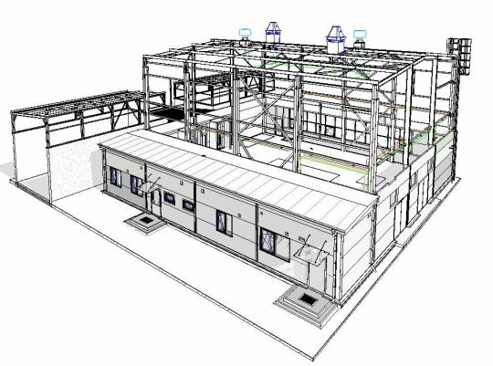
Building Information Modeling (BIM) is a digital representation of a building's physical and functional characteristics. It is a collaborative process that involves the generation and management of digital representations of the physical and functional characteristics of a facility. These representations, often 3D models, contain information that is crucial for decision-making throughout a building's lifecycle, from design and construction to operation and maintenance.
The Key Applications of BIM in Construction
BIM technology offers a wide range of applications in the construction industry, each contributing to improved efficiency, reduced costs, and enhanced project outcomes.
a. Design and Visualization: BIM allows architects and designers to create highly detailed 3D models of buildings. These models provide a comprehensive view of the structure, helping in better design visualization and early identification of design flaws.
b. Clash Detection: BIM software can automatically detect clashes or conflicts in the design phase, such as plumbing and electrical systems intersecting. This early identification helps in reducing costly on-site changes.
c. Quantity Takeoff: BIM software can generate accurate quantity takeoffs from the 3D model, streamlining the estimation process and reducing errors in project cost calculations.
d. Construction Planning: BIM aids in creating construction schedules and sequencing plans. It allows project managers to visualize the entire construction process and optimize resource allocation.
e. Cost Estimation and Management: BIM can integrate with cost estimation software, providing real-time cost updates based on design changes. This ensures that the project stays within budget.
f. Facility Management: BIM models continue to be valuable even after construction. They serve as a comprehensive database of information for facility managers, aiding in maintenance and operations.
BIM Software Development and Its Importance
The effectiveness of BIM in construction relies heavily on the quality and capabilities of BIM software. BIM software development plays a pivotal role in enhancing BIM's applications and making it more adaptable to evolving industry needs. Here's how:
a. Customization: BIM software development allows for the customization of BIM tools to meet specific project requirements. This ensures that BIM solutions are tailored to the unique needs of each construction project.
b. Integration: BIM software development enables the integration of BIM with other construction technologies and software, such as project management tools, ERP systems, and data analytics platforms. This integration enhances data flow and collaboration across project stakeholders.
c. Automation: BIM software development can automate various processes, such as clash detection, quantity takeoff, and cost estimation. This reduces human errors, accelerates project timelines, and improves overall project efficiency.
d. Compatibility: BIM software developers work on ensuring compatibility with various file formats and standards, making it easier for different teams to collaborate seamlessly, regardless of the software they use.
e. Mobile Applications: BIM software development also extends to mobile applications, allowing on-site teams to access and update BIM data in real-time using smartphones and tablets.
ProtoTech Solutions: A Pioneer in BIM Software Development
ProtoTech Solutions is a leading name in the field of BIM software development. With a track record of delivering innovative solutions for the construction industry, ProtoTech has played a significant role in advancing the capabilities of BIM technology. Some key contributions of ProtoTech in BIM software development include:
ProtoTech's BIM tools are known for their accuracy and efficiency in clash detection, helping construction teams identify and resolve issues early in the design phase.
ProtoTech's BIM software is highly customizable, allowing construction companies to tailor the solution to their specific project needs.
The company's focus on automation has led to the development of BIM tools that can generate quantity takeoffs and cost estimates rapidly, reducing project delays and budget overruns.
ProtoTech's commitment to compatibility ensures that its BIM solutions can seamlessly integrate with a wide range of software and platforms, promoting collaboration among project stakeholders.
Conclusion
Building Information Modeling (BIM) has transformed the construction industry, offering numerous applications that improve project efficiency and outcomes. BIM software development, exemplified by companies like ProtoTech Solutions, plays a crucial role in enhancing the capabilities of BIM technology. As construction projects become more complex, the role of BIM in streamlining processes, reducing errors, and optimizing resource allocation will only become more critical. With the continuous advancement of BIM software, the construction industry is poised for a future of greater innovation and efficiency.
#bim application development#bim software development#bim application developer#bim software solutions#bim software services#bim application#bim viewer software#custom bim software#bim visualization app#bim visualization software#bim modelling software#bim applications in construction#application of bim in construction
0 notes
Text
Top 5 Home Design and Construction Software
The home design and construction industry has evolved significantly with the advent of technology, leading to the development of sophisticated software tools that enhance design processes, improve collaboration, and streamline project management. Here, we explore the top five home design and construction software options available today, highlighting their features, benefits, and suitability for…
View On WordPress
#3D modeling software#Archicad review#architectural design tools#architectural visualization software#AutoCAD for architects#best home design software#BIM software#CAD software#Chief Architect features#collaborative design tools#construction project management tools#construction software#home design applications#home design software#interior design software#residential design software#Revit alternatives#SketchUp benefits
0 notes
Text
BIM -Building Information Modeling |Revolutionizing Construction
BIM, or Building Information Modeling, transforms construction and engineering projects by integrating data for planning, design, construction, and management. This comprehensive approach improves project visualization and coordination, making decision-making easier and reducing risks. In this blog, we’ll delve into the essential software components of BIM, including 3D modeling, data management,…
#applications of BIM#Benefits of BIM#BIM#BIM model#BIM objects#Building information modeling#construction#Future trends in BIM#what is bim software?
1 note
·
View note
Text
3D Laser Scanning – Types | Benefits | Applications

3D Laser Scanning
3D laser scanning techniques have been developed since the end of 1990s for 3D digital measurement, documentation and visualization in several fields including 3D design in processing industry, documentation and surveying in architecture and infrastructure. By using a 3D laser scanner, a tunnel or underground construction can be digitized in 3D with a fast-scanning speed and high resolution up to “mm” level.
The scanning data consists of not only XY-Z co-ordinates but also high-resolution images, either gray-scale (with reflex intensity data) or color (with RGB data), and then can be transformed into a global co-ordinate system by control survey. Therefore, any rock engineering objects with its as-built situation can be quickly recorded as the 3D digital and visual format in a real co-ordinate system and provides a potential application for 3D measurement, documentation and visualization with high resolution and accuracy.
In modern engineering the term ‘laser scanning’ meaning is the controlled steering of laser beams followed by a distance measurement at every direction. This method, often called 3D object scanning or 3D laser scanning, is used to rapidly capture shapes of objects, buildings, and landscapes.
What is 3D Laser Scanning?
3D laser scanning is a non-destructive, non-contact method of capturing data that can be used for rapid and accurate creation of three-dimensional files, for archiving and digital manipulation. A 3D laser scanner emits a narrow laser beam that hits a target object, gathering millions of closely spaced measurements in a matter of minutes. These scanned measurements are put together and grouped into compressed point cloud databases, which can be processed to generate a 3D dense representation of the object.
3D Scanners Bridging Physical and Digital Worlds
3D scanners are tri-dimensional measurement devices used to capture real-world objects or environments so that they can be remodeled or analyzed in the digital world. The latest generation of 3D scanners do not require contact with the physical object being captured.
3D scanners can be used to get complete or partial 3D measurements of any physical object. The majority of these devices generate points or measures of extremely high density when compared to traditional “point-by-point” measurement devices.
How 3D Scanning Works?
Scanning results are represented using free-form, unstructured three-dimensional data, usually in the form of a point cloud or a triangle mesh. Certain types of scanners also acquire color information for applications where this is important. Images/scans are brought into a common reference system, where data is merged into a complete model. This process — called alignment or registration — can be performed during the scan itself or as a post-processing step.
Computer software can be used to clean up the scan data, filling holes, correcting errors and improving data quality. The resulting triangle mesh is typically exported as an STL (STereoLithography or Standard Tessellation Language) file or converted to Non-uniform Rational B-Spline (NURBS) surfaces for CAD and BIM modeling.
Types of Laser Scanning
1. Airborne Laser Scanning (LiDAR)
Airborne laser scanning (LiDAR = acronym for ‘Light detection and Ranging’, also LIDAR) is a scanning technique for capturing data on the features of, and objects on, the surface of the earth. It is an important data source in environmental studies, since it is capable of mapping topographic height and the height of objects on the surface to a significant vertical and horizontal accuracy, and over large areas. Airborne laser scanning is an active remote sensing technology able to rapidly collect data from vast areas.
2. Terrestrial Laser Scanning
Terrestrial Laser Scanners (TLS) are positioned directly on the ground, or on a platform placed on the ground, and are normally mounted on a tripod. TLS is, in its essence, an improved version of the laser tachometric measurement toolkit (the so-called total station) that is based on the combination of distances and angles measured from a fixed point. Tachometric laser scanners digitize objects of interest with a frequency of 1000 Hz or higher. Each point is measured per one oblique distance and, additionally, two orthogonal angles are measured. Most TLS are long-range devices. Nowadays, a great variety of TLS is available with different range and pulse frequencies.
3. Handheld (portable) Laser Scanning
There has recently been an increase in the application of handheld scanners. Their basic advantage is their portability. Scanners that are attached to light portable stands fall in this category as well, even though they are not ‘handheld’ in the true sense of the word. Primary used in reverse engineering, nowadays they are very often employed in digital documentation of moveable cultural heritage objects.
4. Long- and Short-Range Laser Scanning
Long-range laser scanning is tailored for surveying and monitoring expansive areas or structures. Using high-powered lasers and advanced optics, it covers distances from yards to miles/meters to kilometers. Employing time-of-flight or phase-based technologies, it finds applications in geological surveys, urban planning, infrastructure monitoring, and archaeological site mapping. Short-range laser scanning focuses on high-precision tasks within confined spaces. Covering distances from centimeters to meters/ feet to yards, it utilizes structured light or laser triangulation. Widely used in industrial metrology, 3D scanning, quality control, and cultural heritage preservation, it excels in capturing fine details with accuracy.
3D Scanning File Formats
TZF: This format is a Trimble scan files in a zipper format. The software exports the current project as a folder with:
• One TZF format file per station • One TCF format file per station if the station has been acquired with images
E57: This format is a file format specified by the ASTM (American Society of Testing and Materials), an international standards organization. The E57 format supports two types of data: Gridded Data and Non-Gridded Data. Gridded Data is a data which aligned in regular arrays.
E57 Gridded Files: The software exports the current project as one LAS 1.2 format file.
E57 Non-Gridded Files: The software exports the current project as one LAS 1.2 format file.
PTX: This format is an ASCII based for scan file format. The software exports the current project as one LAS 1.2 format file.
LAS, Non-Gridded: The format is public file format for interchanging 3-dimensional point cloud data between users. It is binary-based and has several versions: 1.0, 1.1, 1.2, 1.3 and 1.4. The application exports the current project as one LAS 1.2 format files.
POD, Non-Gridded: The POD (Point Database) file format is Bently Pointools’ native point cloud format. The software exports the current project as one POD format file. Points, color, intensity and normal (if available) information are exported.
RCP: This format file is a project file for Recap from Autodesk. The software exports the current project as one RCP format file.
TDX: TDX is Trimble Data eXchange file format, commonly used in some Trimble software applications like TBC (Trimble Business Center) or RealWorks. The software exports the information listed below:
• Stations with registration sets • Created panorama(s) • Measured points • Leveling information
Benefits of 3D Laser Scanning
3D laser scanning has become an indispensable tool across many industries due to its ability to capture highly detailed and more accurate 3D data. Here are some of the key benefits of 3D laser scanning:
High Accuracy
Laser scanning provides extremely accurate measurements, making it effective for applications where precision is critical, such as engineering, construction, and product manufacturing.
Rapid Data Capture
Laser scanners can quickly collect a large amount of data, reducing the risk associated with scanning high buildings and improving field staff safety.
Non-contact Technology
Laser scanning is noninvasive and doesn’t require physical contact with the object or environment being scanned, making it ideal for fragile, hazardous, or hard-to-reach locations.
Comprehensive Documentation
Laser scanning creates detailed and comprehensive digital records of objects, buildings, or landscapes, which are invaluable for preservation and historical archiving.
Visualization
Data from 3D laser scans can be used to create highly realistic visualizations, aiding in the design, analysis, and communication of complex structures and spaces.
Clash Detection
When integrated with building information modeling (BIM), laser scanning helps identify clashes between design plans and existing structures, reducing costly construction errors.
Applications of 3D Laser Scanning
3D Laser Scanning is used in numerous applications: Industrial, architectural, civil surveying, urban topography, reverse engineering, and mechanical dimensional inspection are just a few of the versatile applications. 3D laser scanning technology allows for high resolution and dramatically faster 3D digitizing over other conventional metrology technologies and techniques. Some very exciting applications are animation and virtual reality applications.
1. Construction Industry and Civil Engineering
a. As-built drawings of bridges, industrial plants and monuments b. Documentation of historical sites c. Site modelling and lay outing d. Quality control e. Quantity surveys f. Freeway redesign g. Establishing a benchmark of prre-existing shape/state in order to detect structural changes resulting from exposure to extreme loadings such as earthquake, vessel/truck impact or fire. h. Create GIS (Geographic Information System) maps and Geomatics
2. Reverse Engineering
Reverse Engineering refers to the ability to reproduce the shape of an existing object. It is based on creating a digitized version of objects or surfaces, which can later be turned into molds or dies. It is a very common procedure, which has diverse applications in various industries. Non- contact 3D laser scanning allows even malleable objects to be scanned in a matter of minutes without compression, which could change their dimensions or damage to their surfaces. Parts and models of all sizes and shapes can be quickly and accurately captured. 3D laser scanning for reverse engineering provides excellent accuracies and helps to get products to market quicker and with less development and engineering costs. 3D Laser scanning provides the fast, accurate, and automated way to acquire 3D digital data and a CAD and BIM model of part’s geometry for reverse engineering when none is available. Also, new features and updates can be integrated into old parts once the modeling is accomplished. A practical mechanical and civil engineering application would be to assist in the production of "as built" data and documentation. Currently, many manufacturing or construction activities are documented after the actual assembly of a machine or civil project by a designer or engineering professional. 3D laser scanners could expedite this activity to reduce man-hours required to fully document an installation for legacy.
3. Mechanical Applications
Reverse engineering of a mechanical component requires a precise digital model of the objects to be reproduced. Rather than a set of points a precise digital model can be represented by a polygon mesh, a set of flat or curved NURBS surfaces, or ideally for mechanical components, a CAD solid model. A 3D scanner can be used to digitize free-form or gradually changing shaped components as well as prismatic geometries whereas a coordinate measuring machine is usually used only to determine simple dimensions of a highly prismatic model. These data points are then processed to create a usable digital model, usually using specialized reverse engineering software.
4. Civil Applications
Civil activities could be for a roadway periodic inspection. The digitized roadway data could be contrasted to previous roadway 3D scans to predict rate of deterioration. This data could be very helpful in estimating roadway repair or replacement costing information. When personnel accessibility and/or safety concerns prevent a standard survey, 3D laser scanning could provide an excellent alternative. 3D Laser scanning has been used to perform accurate and efficient as-built surveys and before-and after construction and leveling survey.
5. Design Process
Design process including: a. Increasing accuracy working with complex parts and shapes b. Coordinating product design using parts from multiple sources c. Updating old CD scans with those from more current technology d. Replacing missing or older parts e. Creating cost savings by allowing as-built design services, for example: automotive manufacturing plants. f. “Bringing the plant to the engineers” with web shared scan and saving travel costs.
Conclusion
3D laser scanning equipment senses the shape of an object and collects data that defines the location of the object’s outer surface. This distinct technology has found applications in many industries including discrete and process manufacturing, utilities, construction. Laser scanning technology has matured and developed in the past two decades to become a leading surveying technology for the acquisition of spatial information.
The high-quality data produced by laser scanners are now used in many of surveying’s specialty fields, including topographic, environmental, and industrial. These data include raw, processed, and edited dense point clouds; digital terrain and surface models; 3D city models; railroad and power line models; and 3D documentation of cultural and historical landmarks. 3D laser scanners have a wide range of applications which applicable to very small object to a wide range area.
#3DLaserScanning#ScantoBIMservices#BIMModelingServices#AirborneLaserScanning#TerrestrialLaserScanning#LongRangeLaserScanning#ShortRangeLaserScanning#BIMServices#Benefitsof3DLaserScanning#Applicationsof3DLaserScanning
1 note
·
View note
Text
Architectural 2D CAD Drafting & Design Services: Ensuring Precision and Quality
Architectural 2D CAD Drafting
Architectural 2D CAD drafting is the backbone of modern design workflows, offering precise and detailed technical drawings for projects of all scales. Whether it’s floor plans, elevations, or technical drawings, Architectural 2D CAD Drafting & Design Services ensure every detail is accurately represented, eliminating errors and streamlining construction processes.
With advanced tools like AutoCAD and Revit, these services allow architects, engineers, and contractors to work collaboratively, achieving precision and efficiency in their designs.

Importance of 2D CAD Drafting in Modern Architecture
2D CAD drafting services have become an integral part of architectural workflows, helping professionals overcome traditional design challenges. Here's why they are indispensable in modern architecture:
Precision: Every detail, from measurements to layouts, is highly accurate.
Collaboration: CAD files are easily shareable, ensuring all stakeholders are aligned.
Efficiency: Compared to manual drafting, CAD tools significantly reduce the time required to produce drawings.
By integrating 2D drafting and 3D BIM Modeling Services, architects and engineers can move seamlessly from conceptual design to execution while maintaining accuracy and consistency.
Benefits of 2D CAD Drafting for Professionals
For architects, engineers, and contractors, architectural 2D drafting offers numerous benefits, including:
Enhanced PrecisionAccurate drafting reduces errors during construction, ensuring smooth project execution.
Streamlined WorkflowWith 2D drafting and Architectural Design Visualization Services, teams can transition from design to documentation more effectively.
Cost EfficiencyOutsourcing 2D CAD drafting services reduces overhead costs, as there’s no need for maintaining an in-house drafting team.
Flexibility and ScalabilityProjects often require revisions and updates. CAD drafting ensures that modifications are quick and hassle-free without disrupting the entire workflow.
Professionals across industries leverage these benefits to optimize their design and construction processes.
Applications of 2D CAD Drafting
Architectural 2D drafting services have a wide range of applications in design and construction, including:
Floor Plans: Clearly defined layouts for residential, commercial, and industrial buildings.
Elevations: Detailed visual representations of exterior facades for presentations and approvals.
Technical Drawings: Accurate documentation that provides contractors and engineers with essential construction details.
To cater to complex design needs, Architectural CAD Design and Drafting Services provide tailored solutions for architects and engineers, enabling seamless integration of technical precision with creative concepts.
Industries Benefiting from 2D CAD Drafting
Several industries rely on architectural 2D CAD drafting services for achieving project success. Here’s a closer look:
ConstructionPrecise drafting reduces on-site errors, saving time and money during construction. Contractors depend on 2D drafting for creating accurate blueprints.
Interior DesignInterior designers use CAD drafting to create detailed layouts for furniture placement, lighting design, and more.
Real EstateReal estate developers benefit from professional drafting services to create detailed property layouts for presentations and marketing materials.
By relying on Architectural Documentation Services, these industries achieve precision, professionalism, and timely project delivery.
Leveraging Professional CAD Drafting Services
Outsourcing 2D CAD drafting services to experienced professionals can significantly optimize project outcomes. Here’s how:
Expertise: Professional drafters bring years of experience in handling complex drafting requirements.
Cost Savings: Avoid the expenses of maintaining in-house resources by outsourcing CAD drafting tasks.
Scalability: Services are tailored to meet specific project needs, ensuring flexibility and adaptability.
By leveraging Paper to CAD Conversion Services, architects, engineers, and contractors can focus on core project responsibilities while ensuring that designs are accurate and construction-ready.
Conclusion
Architectural 2D CAD drafting services are indispensable for achieving precision, efficiency, and collaboration in modern design projects. From floor plans to elevations and technical drawings, these services provide a solid foundation for successful project execution.
If you're looking to enhance your project outcomes with professional drafting services, get in touch today to see how we can help bring your vision to life.
2 notes
·
View notes
Text
Construction Lasers Market Size, Anticipating Growth Prospects from 2032
The global construction lasers market was valued at US$ 2.67 billion in 2022 and is projected to grow at a CAGR of 4.7%, reaching US$ 4.22 billion by 2032. Between 2017 and 2021, the market recorded a CAGR of 2.1%, as per insights from Fact.MR, a leading market research and competitive intelligence firm.
Engineering and construction (E&C) leaders worldwide are poised to capitalize on evolving market dynamics to benefit their customers, employees, and organizations. In the rapidly changing industrial landscape, modern construction lasers are essential for E&C companies to ensure continuous access to real-time information.
𝐅𝐨𝐫 𝐦𝐨𝐫𝐞 𝐢𝐧𝐬𝐢𝐠𝐡𝐭𝐬 𝐢𝐧𝐭𝐨 𝐭𝐡𝐞 𝐌𝐚𝐫𝐤𝐞𝐭, 𝐑𝐞𝐪𝐮𝐞𝐬𝐭 𝐚 𝐒𝐚𝐦𝐩𝐥𝐞 𝐨𝐟 𝐭𝐡𝐢𝐬 𝐑𝐞𝐩𝐨𝐫𝐭: https://www.factmr.com/connectus/sample?flag=S&rep_id=7872
Country-wise Insights
China's growing adoption of advanced technologies, including Building Information Modeling (BIM), for construction, engineering, and architectural applications has positioned the Asia Pacific region as the largest market for construction laser equipment.
An emerging trend in the industry is the rise of leasing and rental services for construction survey equipment. This trend is creating new opportunities for construction professionals to leverage cutting-edge technology, enabling safer and more efficient project execution.
Driven by these factors, the construction lasers market in China is currently valued at US$ 447 million and is projected to expand by 1.7X by 2032, highlighting the country’s significant role in shaping the industry’s future.
Category-wise Insights
The line laser level is one of the most commonly used laser tools on construction sites. It projects a 180-degree vertical or horizontal beam onto flat surfaces, making it essential for tasks requiring precise vertical and horizontal measurements, particularly in the construction and cabinetry industries.
Primarily utilized for indoor applications, line laser levels are ideal for mounting, installing, plumbing, and leveling tasks. Some models, known as cross-line laser levels, can simultaneously emit vertical and horizontal lines to form a cross-shaped beam. Advanced variants can even project a 360-degree line around a space, offering functionality similar to rotating laser levels.
The growing demand for precision tools in construction and related industries has positioned line laser levels as a critical tool. The line laser levels market is estimated to achieve a valuation of US$ 863.7 million in 2022, underscoring their widespread adoption and utility.
Read More: https://www.factmr.com/report/construction-lasers-market
Competitive Landscape
Leading manufacturers in the construction laser market include AdirPro, DEWALT, Hilti Corporation, Johnson, Kapro Industries, Leica Geosystems (a Hexagon company), Milwaukee Tool, Pacific Laser Systems (Fluke Corporation), Paragon Instruments, Robert Bosch, Spectra Precision, STABILA Messgeräte Gustav Ullrich, Stanley Black & Decker, Topcon Positioning Systems, and Trimble.
These companies are increasingly focusing on integrating smart technology into their products, enhancing efficiency and precision for end-users. Collaborations with professionals in the engineering and construction industries are also enabling manufacturers to streamline their operations and reduce reliance on mid-level market players.
Additionally, key players are prioritizing regional expansion to strengthen their market presence. This strategic focus is expected to drive sales growth and improve profit margins for construction laser manufacturers.
Notable developments include Trimble's contract with the U.S. Army in February 2022 to supply grade control and laser leveling devices for heavy construction machinery, valued at approximately US$ 1.7 million. In November 2022, Topcon announced the launch of its new rotating laser, RL-HV2, designed to replace the RL-SV series, offering enhanced features to meet evolving industry demands.
𝐆𝐞𝐭 𝐂𝐮𝐬𝐭𝐨𝐦𝐢𝐳𝐚𝐭𝐢𝐨𝐧 𝐨𝐧 𝐭𝐡𝐢𝐬 𝐑𝐞𝐩𝐨𝐫𝐭 𝐟𝐨𝐫 𝐒𝐩𝐞𝐜𝐢𝐟𝐢𝐜 𝐑𝐞𝐬𝐞𝐚𝐫𝐜𝐡 𝐒𝐨𝐥𝐮𝐭𝐢𝐨𝐧𝐬: https://www.factmr.com/connectus/sample?flag=RC&rep_id=7872
Segmentation of Construction Lasers Industry Research
By Type of Laser :
Spot/Plumb/Dot Lasers
Line Level Lasers
Single Beam Laser
Multi-Beam Lasers
Rotary Level Lasers
Fixed Rotation Speed
Variable Rotation Speed
Combination Lasers (Emit both lines and spots)
Others (Pipe Lasers, Grade Lasers Etc.)
By Operation :
Manual-Leveling Lasers
Self-Leveling and Automatic-Leveling Lasers
By Range :
Up to 25 Meters
25 Meters to 50 Meters
50 Meters to 100 Meters
100 Meters to 150 Meters
150 Meters to 200 Meters
Above 200 Meters
By Application :
Indoor
Distance Measuring
Floor Leveling
Height Measuring
Aligning
Outdoor
Plumbing
Surveying
Elevation Measurements
Site Layout
By Region :
North America
Latin America
Europe
East Asia
South Asia & Oceania
MEA
𝐂𝐨𝐧𝐭𝐚𝐜𝐭:
US Sales Office 11140 Rockville Pike Suite 400 Rockville, MD 20852 United States Tel: +1 (628) 251-1583, +353-1-4434-232 Email: [email protected]
1 note
·
View note
Text
Mastering AutoCAD: A Comprehensive Guide to Advanced Design Challenges

In the dynamic realm of design and drafting, the mastery of AutoCAD stands as a cornerstone skill for individuals aspiring to excel in fields such as engineering, architecture, and design. As students embark on their academic journey toward a Master's degree, they are met with a series of intricate challenges that extend beyond routine tasks, pushing the boundaries of their technical expertise. These challenges not only serve as assessments of their proficiency in AutoCAD but also require a strategic and innovative mindset to navigate complex problem-solving scenarios. This blog aims to delve into the intricacies of five master's degree level questions in AutoCAD, unraveling the layers of complexity inherent in the world of computer-aided design and providing valuable insights for those navigating this educational landscape.
The pursuit of excellence in AutoCAD at the master's degree level demands a holistic understanding of the software's capabilities, creative problem-solving skills, and a willingness to seek assistance when faced with intricate challenges. Help with AutoCAD assignments becomes not just a keyword but a beacon guiding students through the complexities of advanced design tasks, fostering a learning environment where theoretical knowledge meets practical application, ultimately preparing them for success in the ever-evolving field of computer-aided design.
1. Advanced 3D Modeling in AutoCAD
Problem: The challenge begins with designing a complex 3D model incorporating diverse geometric shapes. The solution not only involves creating intricate shapes but also optimizing the model for efficient rendering. This question delves into not just the technical aspects of modeling but also strategic considerations for a seamless design process.
2. Dynamic Blocks and Parametric Design
Problem: Dynamic blocks and parametric design are at the forefront of modern CAD practices. Creating a parametrically controlled dynamic block for a furniture component challenges students to think beyond static designs. The solution involves understanding the dynamic properties, establishing relationships between parameters, and discussing the advantages of dynamic blocks in real-world design workflows.
3. AutoCAD Customization with AutoLISP
Problem: AutoLISP programming is a powerful tool for customization in AutoCAD. Crafting a custom command or routine to streamline a specific design task showcases not only programming skills but also the practical application of customization in a professional setting. The solution includes providing the complete AutoLISP code, explaining its functionality, and discussing its impact on workflow efficiency.
4. Collaborative Design in AutoCAD
Problem: Collaborative design is a crucial aspect of many projects. This question challenges students to create a multi-user environment in AutoCAD, emphasizing features like "Xref," "Sheet Sets," or "CAD Standards" to streamline collaboration. The solution addresses challenges in coordinating design changes, managing references, and ensuring consistency across the project.
5. AutoCAD and BIM Integration
Problem: The integration of AutoCAD into a Building Information Modeling (BIM) workflow is a contemporary challenge. Students are tasked with showcasing the interoperability of AutoCAD with BIM tools and discussing the advantages of this integration. This question highlights the importance of understanding how AutoCAD fits into broader design and construction processes.
Help with AutoCAD Assignments: Navigating the Complexity
Undoubtedly, mastering AutoCAD requires a combination of theoretical knowledge and practical application. As students grapple with these challenging questions, seeking help with AutoCAD assignments becomes crucial. Understanding the nuances of each problem and refining one's skills often involves guidance from experts in the field.
Whether it's elucidating the intricacies of 3D modeling, unraveling the mysteries of AutoLISP programming, or addressing the challenges of collaborative design, a reliable source of assistance can make a significant difference. For those seeking help with AutoCAD assignments, various online platforms and professional tutors offer personalized guidance to ensure a deeper understanding of the subject matter.
In conclusion, tackling master's degree level AutoCAD questions goes beyond routine design tasks. It requires a holistic understanding of the software's capabilities, strategic thinking, and the ability to adapt to modern design practices. As students navigate these challenges, seeking assistance not only enhances their learning experience but also sets the foundation for a successful career in the dynamic world of computer-aided design.
#Autocad Assignment Help#Autocad Assignment Helper#Help with Autocad Assignments#Do My Autocad Assignment#Complete My Autocad Assignment
8 notes
·
View notes
Text

Gsource Technologies offers cutting-edge Lidar and Photogrammetry services, revolutionizing geospatial data acquisition and analysis. Our expertise extends across diverse applications, including Digital Terrain and Surface Models, enabling precise elevation mapping for various projects. We specialize in 3D Modeling and web viewers, providing immersive visualizations for enhanced project understanding. Feature Extractions are meticulously performed to identify and analyze key elements, ensuring comprehensive data interpretation.
Our Scan to BIM services facilitate seamless integration of Lidar data into Building Information Modeling processes, enhancing accuracy in construction and design. Additionally, we excel in 2D Linework, CAD Conversions, and Automated Contours, streamlining design workflows. Gsource Technologies' commitment to excellence is further evident in Topo Creation, where we generate detailed topographic maps to meet project specifications. With state-of-the-art technology and a skilled team, we deliver comprehensive Lidar and Photogrammetry solutions tailored to meet the evolving needs of diverse industries.
2 notes
·
View notes
Text
13 Revolutionary Technologies Driving Change Across Industries
This article explores the biggest technology trends that are shaping and transforming diverse industries in 2023. Some of the major innovations highlighted include edge computing, quantum computing, extended reality, metaverse, and generative AI. These cutting-edge technologies are revolutionizing various sectors and domains.
The article explains that businesses can optimize costs, boost customer experience, and increase revenue by adopting new technologies like robotic process automation, autonomous vehicles, Web3 applications, and sustainable "green" technologies.
Specific technology trends are highlighted across various industries. In e-commerce, mobile commerce and personalization are big trends. In education, online learning and educational technology tools are gaining prominence. The automotive industry is seeing major disruption from trends like electric vehicles and advanced driver assistance systems. Construction is leveraging innovations like building information modeling (BIM) 2.0 and digital twins. And healthcare is being transformed through telehealth platforms and electronic health records.
Helpful tips are provided for both individuals and businesses on how to keep up with the rapid pace of technological change - from reading industry publications, to monitoring competitors, to participating in online tech forums.
The key takeaway is that leveraging insights gained from emerging technology trends will allow organizations to remain competitive, innovative, and responsive to evolving consumer needs. Overall, the article covers the most important tech innovations to be aware of across diverse sectors. View full post at:https://ltsgroup.tech/blog/technology-trends/
2 notes
·
View notes
Text
Top Reasons to Choose 3D Laser Scanning Services in UAE: Leading Dubai Companies Revealed
In today’s fast-paced engineering, construction, and architectural industries, precision and efficiency are crucial. That’s where 3D laser scanning services in UAE come into play. These advanced scanning solutions provide highly accurate digital representations of real-world environments, enabling professionals to make data-driven decisions with confidence.
If you're looking to reduce rework, cut down project timelines, and improve accuracy, it’s time to explore how 3D scanning services in UAE can elevate your project outcomes. In this article, we’ll explain why many businesses trust leading 3D scanning companies in Dubai—especially innovative firms like Conserve UAE—to get the job done right.
What Are 3D Laser Scanning Services?
3D laser scanning is a cutting-edge technology used to capture detailed, high-precision data of physical structures or environments. Using laser light, scanners generate point clouds that are transformed into digital 3D models, which can be used for BIM (Building Information Modeling), construction documentation, retrofitting, facility management, and more.
With Conserve UAE, you gain access to advanced 3D laser scanning services in UAE that deliver unparalleled accuracy and actionable insights.
Why Choose 3D Scanning Services in UAE?
The UAE is home to some of the most complex and innovative construction and infrastructure projects in the world. This creates a high demand for quality-driven 3D scanning services in UAE, and here’s why these services are essential:
✅ Precision and Accuracy
Whether you’re working on a high-rise building in Dubai or an industrial facility in Abu Dhabi, 3D laser scanning services help eliminate guesswork by providing accurate measurements and geometry.
✅ Cost and Time Efficiency
By reducing manual surveying errors and minimizing on-site rework, 3D scanning services significantly reduce project timelines and costs.
✅ Ideal for Renovation and Retrofit Projects
3D scanning companies in Dubai often work with clients looking to renovate or retrofit existing structures. The scanning data allows engineers and architects to work with exact as-built models.
✅ Improved Safety
By capturing detailed visuals remotely, 3D scanning minimizes the need for manual inspection in potentially hazardous areas.
Why Conserve UAE is a Trusted 3D Scanning Company in Dubai
When searching for a reliable 3D scanning company in Dubai, Conserve UAE stands out for its commitment to quality, innovation, and client satisfaction.
💡 Experience with Diverse Sectors
From oil & gas to commercial buildings and infrastructure, Conserve UAE provides tailored 3D laser scanning services in UAE that meet industry-specific standards.
💡 Advanced Technology
We use high-performance terrestrial laser scanners and drones to collect precise data, even in complex or hard-to-reach areas.
💡 Fast Turnaround
Time is money. Our experts ensure you get processed data and detailed 3D models quickly so you can keep your project on schedule.
Applications of 3D Scanning in UAE Projects
Here’s where our 3D scanning services in UAE make a difference:
As-Built Documentation
Clash Detection for BIM
Structural Analysis & Monitoring
Historical Building Conservation
Offshore Facility Scanning
Construction Progress Monitoring
Choose the Right 3D Scanning Partner in Dubai
With numerous 3D scanning companies in Dubai, it’s essential to work with a partner that understands both the technology and your industry. At Conserve UAE, our team of engineers, BIM experts, and 3D scanning specialists collaborate to deliver results that exceed expectations.
Final Thoughts
The growing demand for accuracy, cost-efficiency, and innovation makes 3D laser scanning services in UAE a smart choice for any project. Whether you're managing a large-scale construction or upgrading an existing facility, partnering with a top-tier 3D scanning company in Dubai like Conserve UAE ensures your project is backed by precision, speed, and reliability.
Get in touch with Conserve UAE today to learn how our 3D scanning solutions can support your next project.
#3d laser scanning services uae#3d scanning company dubai#3d scanning companies dubai#3d scanning services uae
0 notes
Text
How do structural BIM services help BIM Engineering projects?

Introduction
In the dynamic world of engineering and construction, Building Information Modeling (BIM) has emerged as a revolutionary technology, reshaping the way projects are conceptualized, designed, and executed. Among the various facets of BIM, Structural BIM services play a pivotal role in enhancing the efficiency, accuracy, and collaboration within engineering projects. This blog explores the manifold ways in which Structural BIM services contribute to the success of BIM engineering projects.
1. Accurate and Detailed Design:
Structural BIM services enable engineers to create highly accurate and detailed 3D models of structures. This level of precision ensures that every aspect of the design is thoroughly examined, helping identify potential issues before they manifest in the physical construction phase. The virtual representation allows for a comprehensive understanding of the structural elements, leading to improved decision-making and problem-solving.
2. Enhanced Collaboration:
One of the key advantages of BIM is its ability to facilitate collaboration among various stakeholders in a project. Structural BIM services bring architects, engineers, contractors, and other professionals onto a common platform. This collaborative environment promotes effective communication, reduces errors, and ensures that everyone is working with the most up-to-date information. This interconnectedness leads to a streamlined workflow and, ultimately, a more successful project outcome.
3. Clash Detection and Coordination:
In complex engineering projects, clashes between different building systems can be a significant challenge. Structural BIM services include clash detection capabilities, allowing engineers to identify and resolve conflicts early in the design phase. This proactive approach minimizes the likelihood of costly errors during construction and contributes to a smoother, more efficient project timeline.
4. Quantities and Cost Estimation:
Structural BIM models are not only a visual representation but also store a wealth of data related to quantities and materials. This information can be leveraged for accurate cost estimation and procurement planning. Engineers can extract detailed material quantities, enabling precise budgeting and resource allocation. This feature helps project managers make informed decisions and avoid budget overruns.
5. Efficient Construction Management:
Structural BIM services extend beyond the design phase to support construction management. The 4D and 5D capabilities of BIM, which incorporate time and cost dimensions, allow for the simulation and optimization of construction sequences. This results in improved project scheduling, resource utilization, and overall project efficiency.
6. Lifecycle Management:
Structural BIM models serve as a valuable asset throughout the entire lifecycle of a structure, from design and construction to operation and maintenance. The data-rich models can be used for facility management, renovations, and even demolition planning. This holistic approach to project management ensures that the benefits of BIM extend beyond the initial construction phase.
Conclusion
In conclusion, Structural BIM services are indispensable for modern engineering projects, offering a plethora of benefits that enhance efficiency, collaboration, and overall project success. As the construction industry continues to embrace digital transformation, the integration of Structural BIM services will become increasingly integral to the way we conceive, design, and build structures. Embracing these technologies not only improves project outcomes but also positions the industry for continued innovation and growth.
Want to Outsource Construction App Development? Thinks of ProtoTech!
ProtoTech Solutions is at the forefront of 3D application development, transforming the AEC industry by providing state-of-the-art tools that streamline workflows, enhance collaboration, and elevate project outcomes. Elevate your AEC projects with our innovative solutions and experience the future of 3D application development.
Our innovative solutions redefine the way professionals in the AEC sector conceptualize, design, and execute projects. ProtoTech Solutions is a trailblazing software development company specializing in creating robust and intuitive 3D applications specifically crafted to meet the unique demands of the AEC industry. Our expertise lies in seamlessly integrating advanced technologies to enhance the entire project lifecycle, from initial design to construction and beyond.
#Structural BIM services#Construction App Development#3D application development#BIM Application Development
0 notes
Text
Exploring the Diverse Landscape of BIM Software in Construction: A Comprehensive Guide
Introduction: In the ever-evolving field of construction, Building Information Modeling (BIM) has emerged as a transformative technology that revolutionizes the way buildings are designed, constructed, and managed. BIM software plays a pivotal role in enhancing collaboration, improving efficiency, and minimizing errors throughout the construction process. This article delves into the various…
View On WordPress
#architectural design software#as-built documentation#BIM model accuracy#BIM software#Building Information Modeling#collaboration platforms#construction industry advancements#construction management software#construction project efficiency#Construction Technology#cost estimation tools#facility maintenance optimization#facility management solutions#laser scanning technology#LiDAR applications#MEP systems modeling#point cloud integration#project stakeholders collaboration#real-time coordination#structural engineering tools#sustainable building practices
0 notes
Text
Essential Skills for Structural Drawing Production with AutoCAD & Revit
Structural drawings are the backbone of any construction project because they convert intricate engineering calculations into precise, buildable plans. For aspiring and current drafters, engineers, and architects, proficiency in industry-standard software like AutoCAD and Revit is non-negotiable. But it's not just about knowing the buttons; it's about mastering a specific set of skills that transforms good drawings into exceptional ones.
The Foundation: Core Drafting Principles
Before we even touch software, a strong grasp of fundamental drafting principles is paramount. These timeless skills ensure clarity, accuracy, and consistency in your work:
Understanding Engineering Concepts: This isn't about being a structural engineer, but understanding basic load paths, common structural elements (beams, columns, slabs, footings), and reinforcement principles will make your drawings more intelligent and error-resistant. You'll be able to anticipate potential clashes or design issues.
Orthographic Projections & Sectioning: Being able to visualize and accurately represent 3D structures in 2D views (plans, elevations, sections) is fundamental. This includes understanding cutting planes and how they reveal internal details.
Dimensioning & Annotation Standards: Precision is key. Knowing how to apply dimensions correctly, adhere to industry standards (like ISO or AISC), and effectively annotate drawings with notes, symbols, and callouts ensures clear communication.
Layer Management & Lineweight Control: Organized drawings are efficient drawings. Mastering layers for different elements (concrete, rebar, steel, dimensions, text) and applying appropriate lineweights for visual hierarchy makes your drawings readable and professional.
Attention to Detail & Accuracy: This might sound obvious, but overlooking small details can lead to significant errors on site. Meticulous checking of every line, dimension, and annotation is crucial.
AutoCAD: Precision and Control for 2D Structural Drawings
AutoCAD remains a powerful tool, especially for detailed 2D structural drawings where fine control over lines and text is required. Here are the key skills for structural drafters using AutoCAD:
Proficiency in Core Drawing Commands: Beyond the basics, you'll need to master commands like OFFSET, TRIM, EXTEND, FILLET, CHAMFER, ARRAY, BLOCK, and XREF to efficiently create and manage drawing elements.
Effective Use of Blocks and X-Refs: Creating and managing libraries of standard structural components (e.g., column details, beam sections, typical connections) as blocks, and utilizing external references (X-refs) for architectural or MEP backgrounds, streamlines the drafting process and ensures consistency across large projects.
Hatching and Pattern Application: Accurately representing different materials (concrete, masonry, earth) with appropriate hatch patterns is essential for clarity.
Layouts and Plotting: Setting up title blocks, viewports, scales, and preparing drawings for professional plotting is a critical final step. Understanding plot styles (CTB/STB) for lineweight control is also vital.
Customization (Optional but Valuable): For advanced users, creating custom lisp routines or macros can automate repetitive tasks and significantly boost productivity.
Revit: The Power of BIM for Integrated Structural Models
Revit has revolutionized structural drawing production by introducing Building Information Modeling (BIM). This means you're not just drawing lines; you're building a 3D model with intelligent information, from which all your 2D drawings are derived.
Understanding the BIM Workflow: The biggest shift from AutoCAD is understanding that changes made in the 3D model automatically update all associated 2D views (plans, sections, elevations, schedules). This minimizes errors and improves coordination.
Structural Element Modeling: Proficiently modeling structural columns, beams, walls, floors, foundations, and bracing using Revit's dedicated structural tools. This includes understanding family types, instances, and parameters.
Rebar Modeling and Detailing: Revit's capabilities for modeling reinforcement bars (rebar) are increasingly sophisticated. Skills here include placing individual bars, using rebar sets, creating rebar shapes, and generating rebar schedules and bending lists.
Analytical Model Generation: Understanding how Revit generates an analytical model from your physical model, and how this integrates with structural analysis software, is crucial for engineers and advanced drafters.
View Creation and Management: Creating and organizing various views (structural plans, framing plans, sections, callouts, details) and applying appropriate view templates, visibility/graphics overrides, and filters to control what's seen in each view.
Annotation and Tagging in Revit: While similar to AutoCAD in principle, Revit's intelligent tags and annotations automatically pull information from the model, ensuring consistency and reducing manual input.
Collaboration and Worksharing: In a multi-disciplinary BIM environment, understanding worksharing, central models, and coordination with architectural and MEP models is essential.
Family Creation (Optional but Valuable): For specialized structural elements not found in standard libraries, the ability to create custom parametric families is a powerful skill.
0 notes
Text
Navisworks Vs Revizto – Best Tools for BIM Coordination & Clash Detection

Navisworks vs Revizto: Choosing the Best Tool for BIM Coordination and Clash Detection
When you’re managing a BIM project, the software tools you choose can make a world of difference. Navisworks and Revizto are two major players in this space, each with its own strengths and weaknesses. Whether you’re focused on detailed clash detection or ensuring your team is always on the same page, understanding what each tool offers is key to making the right choice. Let’s dive into a detailed comparison of Navisworks and Revizto to help you decide which one suits your project needs.
Navisworks: The Go-To for Detailed Clash Detection
When you’re managing a BIM project, the software tools you choose can make a world of difference. Navisworks and Revizto are two major players in this space, each with its own strengths and weaknesses. Whether you’re focused on detailed clash detection or ensuring your team is always on the same page, understanding what each tool offers is key to making the right choice. Let’s dive into a detailed comparison of Navisworks and Revizto to help you decide which one suits your project needs.
What Makes Navisworks Stand out?
1. In-Depth Clash Detection:
Pinpointing Every Issue: Navisworks excels at clash detection. Imagine you’re working on a large hospital project. You’ve got structural steel, HVAC systems, plumbing, and electrical conduits all trying to occupy the same space. Navisworks helps you identify where these elements clash with each other—whether it’s a steel beam running into ductwork or plumbing pipes colliding with electrical conduits.
Types of Clashes: Navisworks identifies both hard clashes (physical overlaps) and soft clashes (proximity issues that might cause problems, like inadequate clearances). This dual capability ensures nothing slips through the cracks, giving you the insight needed to address potential problems before they become costly errors on-site.
2. Model Aggregation:
Bringing It All Together: Navisworks can aggregate models from different sources into a single, cohesive environment. For example, you can pull in architectural models from Revit, structural models from Tekla, and MEP systems from AutoCAD or other software. This makes Navisworks particularly valuable for complex projects where coordination between various disciplines is critical.
Support for Multiple File Formats: It doesn’t matter if your data is coming from .RVT, .DWG, .IFC, or other formats—Navisworks handles them all, allowing for seamless integration and a comprehensive project overview.
3. 4D Construction Simulation:
Visualizing the Construction Timeline: With 4D simulation, Navisworks adds the dimension of time to your 3D models. This means you can visualize the construction process step by step, seeing how different phases of the project will unfold over time. For instance, you can map out the sequence of installing structural elements, followed by MEP systems, and then finishes. This helps with scheduling, resource allocation, and identifying potential bottlenecks before they impact the project.
4. Material Takeoff and Quantification:
Accurate Material Estimates: Navisworks includes tools for quantifying materials directly from the model. This feature is crucial for cost estimation and procurement. For example, if you need to know exactly how much steel, concrete, or ductwork your project requires, Navisworks can generate these quantities, helping you plan your budget and orders more accurately.
5. Integration with Autodesk Ecosystem:
A Unified Workflow: Navisworks is part of the Autodesk suite, meaning it works seamlessly with other Autodesk products like Revit, AutoCAD, and Civil 3D. This integration simplifies workflows, especially for firms already embedded in the Autodesk ecosystem. You can move data between these applications without worrying about compatibility issues.
Challenges with Navisworks
Learning Curve: Complex but Rewarding Navisworks is powerful, but that power comes with complexity. It’s not the kind of software you can pick up in a day. Users often need substantial training and practice to master its features, especially when it comes to setting up clash detection rules and interpreting the results.
Hardware Demands: Need for High Performance Because Navisworks is processing large, detailed models, it can be quite resource-intensive. If your hardware isn’t up to par, you might experience slow performance, particularly when working with very large datasets or running extensive clash detection tests.
Revizto: The Collaboration Powerhouse
While Navisworks is all about detailed technical analysis, Revizto is designed to make collaboration effortless. It’s a tool that prioritizes keeping your team connected and ensuring everyone has access to the latest project information—regardless of their technical background.
Why Revizto is a Collaboration Game-Changer?
1. Real-Time Collaboration:
Instant Communication and Updates: Revizto is built for teamwork. Imagine your team is spread across different locations—some in the office, others on-site. Revizto allows everyone to collaborate in real-time, whether they’re marking up a model, leaving comments, or tracking issues. This means faster decision-making and fewer delays caused by miscommunication.
Centralized Data: All project data is centralized in Revizto, so you don’t have to worry about version control or fragmented communication. Everyone is working from the same, up-to-date information, which helps avoid costly mistakes and rework.
2. User-Friendly Interface:
Accessible to All: Revizto’s interface is designed with simplicity in mind. It’s intuitive enough that even those who aren’t BIM experts—like clients, project managers, or contractors—can easily navigate the platform. This broad accessibility ensures that everyone involved in the project can contribute effectively, without getting bogged down in technical details.
2D and 3D Navigation: Whether your team prefers working in 2D plans or exploring the project in 3D, Revizto makes it easy to switch between these views. This flexibility is especially useful for multidisciplinary teams where different members may have different preferences or expertise levels.
3. Issue Tracking and Management:
Keep Everyone Accountable: Revizto’s issue tracking is like a project management tool built into your BIM environment. When a problem is identified—say, a clash, a design flaw, or a construction discrepancy—it’s logged as an issue. You can assign it to the relevant team member, track its status, and ensure it gets resolved. This clear accountability helps keep the project on track and reduces the risk of issues slipping through the cracks.
Detailed Issue Logs: Each issue in Revizto is accompanied by rich data, including its location in the model, the date it was created, who it’s assigned to, and any relevant comments or attachments. This level of detail ensures that issues are thoroughly documented and easily trackable.
4. Clash Detection:
Simplified but Effective: While Revizto does offer clash detection, it’s not as detailed as what you’d find in Navisworks. However, it’s more than sufficient for many projects, especially those that don’t require deep technical analysis. Revizto’s clash detection is tightly integrated with its issue tracking, so clashes can be quickly assigned and addressed as part of the collaborative workflow.
5. Cross-Platform and Cloud-Based:
Work from Anywhere: Revizto’s cloud-based nature means that your team can access the platform from virtually anywhere—whether they’re on a desktop in the office, on a tablet on-site, or even reviewing plans on a smartphone. This flexibility is invaluable for projects where team members are often on the move or working from different locations.
Considerations When Using Revizto
Less Detailed Analysis: Not a Replacement for Advanced Clash Detection If your project requires highly detailed clash detection or complex model aggregation, Revizto might not fully meet your needs. It’s designed more for enhancing collaboration than for deep technical analysis. For such tasks, you might still need to rely on Navisworks or similar tools.
Focus on Communication: More About People, Less About Data Revizto shines in environments where communication and collaboration are the top priorities. If your project is highly technical and you need a tool for extensive data analysis, Revizto’s strengths might feel a bit secondary.
Making the Right Choice: Navisworks or Revizto?
Choosing between Navisworks and Revizto ultimately depends on what your project needs most:
Choose Navisworks if your project is technically complex and requires detailed clash detection, model aggregation from multiple disciplines, and advanced simulations. It’s the tool for when precision and depth are critical, and you have the resources to support its demands.
Choose Revizto if your priority is enhancing team collaboration, keeping everyone on the same page, and managing issues in real-time. It’s the ideal solution for projects where communication, accessibility, and simplicity are key, especially in multidisciplinary teams or projects with less technical oversight.
Conclusion
Both Navisworks and Revizto bring unique strengths to BIM coordination and clash detection. Navisworks is your go-to for detailed, in-depth analysis, making it indispensable for projects where technical accuracy is paramount. Contact BIMPRO LLC for clash detection Services. Revizto, on the other hand, is all about making collaboration seamless and ensuring that every team member, regardless of their technical expertise, can contribute effectively.
By carefully considering your project’s needs and the strengths of each tool, you can make an informed decision that enhances your BIM workflow, minimizes risk, and ensures successful project delivery.
#ClashdetectionServices#BIMCoordinationServices#ClashdetectioninBIM#ClashDetectionForNavisworks#NavisworksForBIMCoordination#ReviztoForBIMCoordination
1 note
·
View note
Text
BIM Modelling Services: Revolutionize Construction through Digital Accuracy
The construction industry has experienced dramatic changes in traditional 2D drawings and manual designs regarding advanced digital processes that improve productivity, accuracy, and collaboration. At the heart of this transformation is the structure of information modelling (BIM). In addition to the various components, BIM modelling services are characterized as critical equipment that allows architects, engineers, contractors, and stakeholders to visualize, plan, and execute projects with unprecedented clarity.
As a leading provider in this field, Edanbrook offers comprehensive BIM modelling services tailored to the diverse requirements of modern buildings. Whether you are working on a residential building, industrial facility, or public infrastructure, BIM modelling plays a key role in ensuring the success of your project from concept to completion.

What is a BIM Modelling service?
BIM modelling services involve the creation of intelligent, data-rich 3D models that digitally represent the physical and functional aspects of the built environment. These models contain detailed information on visual tools as well as materials, spatial relationships, mechanical systems, schedules, and cost estimates.
In contrast to traditional CAD drawings, the BIM modelling serves as the only source of truth throughout the project lifecycle, encouraging decision-making, error detection, resource management, and collaboration among all project participants.
Core Benefits of BIM Modelling Services?
1. Detailed visualisation and clarity of your design
One of the most important benefits of BIM modelling is its ability to visualize complex structures in three dimensions before physical work begins. Customers and stakeholders have a comprehensive understanding of the form, structure, and system integration of the Erlangen building, leading to informed permissions and fewer changes under construction.
2. Interdisciplinary coordination and conflict recognition
BIM enables seamless cooperation between architecture, structural, mechanical, electrical, and sanitation facilities in various fields. By recognizing and resolving early conflicts, BIM modelling reduces rework, minimizes location conflicts, improves coordination, and saves time and money.
3. Cost and time optimisation
The expanded BIM model can be scaled to 4D planning and 5D cost estimates, allowing project managers to efficiently plan,
Forecast Budgets And Identify Cost-Saving Options. These digital simulations can also help you actively coordinate your schedules and resources.
4. Improved project lifecycle management
The BIM model goes beyond design and construction as a valuable asset for facility management and future renovation work. This model includes system data, maintenance plans, and system layouts that support the building ever since it was completed.
Applications for BIM Modelling Services
Edanbrook's BIM modelling services are versatile and tailored to a variety of project phases and areas.
The most important applications include architecture models, catching design intent, floor plans, layout, research, and aesthetic details.
Structural modelling accurately describes columns, beams, plates, and loading elements.
MEP modelling designs complex building systems such as HLK, electricity, water, and fire prevention systems. 4D BIM (planning) integrates time-based project planning into the model.
5D BIM (Cost Estimation) combines budget data with components of the BIM model.
Built modelling creates models according to the structure of furniture and maintenance.
Why did I choose Edanbrook as my BIM modelling service?
Edanbrook brings together a team of experienced BIM specialists, engineers, and designers who are familiar with the latest industry standards and software platforms, including
Autodesk Revit, Navisworks, and Bentley Systems: Our commitment to accuracy, cooperation, and innovation distinguishes us in this area.
Custom-tailored solutions: The two construction projects are not the same. Edanbrook understands this and offers BIM solutions that match your specific customer requirements, project scale, and delivery format.
Global Standards Compliance: Modelling practices meet international BIM standards, including ISO 19650 and local building regulations, ensuring regulation and document consistency.
Collaborative workflow: Our BIM modelling services support Integrated Project Delivery (IPD) and promote transparent collaboration between project teams and improved stakeholder engagement. Scalable and future
Whether it's a small architectural concept or a large infrastructure project, our BIM services are scalable and adaptable to project requirements and future developments.
The future of construction with BIM
The adoption of BIM will accelerate worldwide as construction stakeholders are increasingly aware of the value from an efficiency, quality, and sustainability perspective. The government and the private sector use BIM for developing critical infrastructure and need it for future businesses.
Additionally, the integration of new technologies such as KI, cloud cooperation, laser scanning, and IoT with BIM opens up a new dimension for establishing intelligent structures and lifecycle management. When investing in BIM modelling services today, it's not just about building structures that will build a more intelligent future.
Conclusion
The ability to visualize, coordinate, and execute projects with accuracy and speed in competitive, dynamic building situations. BIM modelling services provide Edge to transform traditional workflows into digitally manipulated data control processes, reducing risk, improving cooperation, and delivering exceptional results.
0 notes
Text
Revolutionizing Precision: 3D Laser Scanning with Penta 3D in Saudi Arabia
3d laser scanning in saudi arabia has emerged as a transformative tool, delivering unparalleled accuracy across diverse industries. By utilizing laser beams to capture precise three-dimensional data from objects, structures, and environments, this technology facilitates the creation of detailed digital models and comprehensive analysis. As Saudi Arabia’s key sectors—such as construction, oil and gas, and manufacturing—continue to thrive, 3D laser scanning plays an increasingly crucial role in enhancing project efficiency and reducing costs.
Penta 3D High-Accuracy Metrology 3D Scanner is at the forefront of this innovation, offering advanced 3D laser scanning solutions tailored to the Kingdom's industrial needs. Armed with state-of-the-art technology and skilled technicians, Penta 3D produces highly accurate digital representations for various applications, including topographic surveys, industrial plant modeling, and the preservation of cultural heritage.
Beyond precision, 3D laser scanning provides significant benefits, such as time and labor savings compared to traditional measurement methods, fewer errors, and seamless compatibility with CAD and BIM platforms. This enhances visualization and optimizes workflows, driving smoother project execution. In Saudi Arabia's fast-paced development landscape, adopting 3D laser scanning with industry leaders like Penta 3D offers a competitive edge by accelerating decision-making, minimizing project risks, and ensuring strict compliance with safety and quality standards.
As Saudi industries continue to embrace this cutting-edge technology, 3D laser scanning is set to redefine the future of precision engineering and construction across the Kingdom.
this transformative technology, 3D laser scanning is redefining the future of engineering, construction, and design. Choosing 3D laser scanning in Saudi Arabia with Penta 3D is not just a technological decision—it’s a step toward smarter, more sustainable progress, empowering businesses to achieve their project goals with exceptional precision.
0 notes