#3DLaserScanning
Explore tagged Tumblr posts
Visit Tumblr Blog
Explore Tumblr blogs with no restrictions, modern design and the best experience.
Last Seen Tumblr Blogs


Fun Fact
Tumblr posted its first advertisements in May 2012 and subsequently earned $13M in revenue.
Text

As-Built Services capture every detail, ensuring your project documentation is a true reflection of excellence.
Surveying and documentation activities are conducted after the completion of a construction project. The primary goal is to accurately capture and record the final built environment, ensuring that the project documentation reflects the as-built conditions with precision.
Elevate your construction journey with the precision you can trust. Ready to redefine accuracy? Let's build together. 🏗️
2 notes
·
View notes
Text
Top Benefits of 3D Laser Scanning Services for Accurate As-Built Documentation & Reality Capture

Tejjy Inc. is a trusted 3D laser scanning company in the USA, offering high-resolution reality capture and accurate as-built data for various industries. Our skilled professionals deliver precise 3D scanning services, providing point cloud data, 3D models, CAD drawings, and digital twins. With an accuracy of 4-6 mm, we cater to diverse sectors, including renovation, surveying, facility management, and heritage preservation. Serving over 150 million square feet, our solutions support general contractors, architects, engineers, asset managers, and more. Whether you need building scanning, lidar services, or 3D scanning, Tejjy Inc. is your go-to for accurate, reliable results.
#3DLaserScanning#LaserScanning#ScanToBIM#3DScanning#RealityCapture#PointCloud#DigitalTwin#Surveying#Architecture#USA
0 notes
Text
Voyage Repair in Ship Repair: Ensuring Safe and Efficient Maritime Operations
Voyage repair is an important part of ship maintenance. It helps keep vessels safe, efficient, and aligned with international standards during their journeys. These repairs happen while a vessel is still on a voyage or transiting via channels/straits. These repairs help technical managers to reduce the idle time for repairs.
Unlike conventional dry dock-based repairs, voyage repairs can rectify defects without interrupting the shipping schedule, preserving the vessel's operational integrity and meeting critical delivery deadlines.
Importance of Voyage Repair
Voyage repair plays a vital role in maintaining a vessel's integrity and performance. By addressing issues promptly during a voyage, ship operators can prevent minor problems from escalating into major faults that could jeopardize safety and lead to costly repairs.
This approach ensures that ships remain operational and can continue their voyages without significant interruptions.
Reduced Downtime: Time spent at sea can be long. Going back to port for small repairs can be costly and wasteful. Voyage repairs allow for operational continuity.
Cost Efficiency: Fixing the ship while still working can reduce docking fees. It also lowers labor costs in big ports and lessens the financial impact of delays.
Improved Safety: Fixing problems quickly while at sea makes it safer. This helps protect the crew, the cargo, and the environment. This helps reduce risks linked to operational failure.
Key Components of Voyage Repair
Periodic Inspections: Regular inspections are essential to monitor the condition of critical ship components such as the hull, engines, and electrical systems. Non-Destructive Testing (NDT) techniques, including Ultrasonic Testing (UT) and Magnetic Particle Inspection (MPI), are employed to detect hidden flaws without dismantling parts of the ship.
Troubleshooting and Repairs: When malfunctions occur, voyage repair teams quickly identify and rectify the issues. This may involve repairing engine parts, fixing leaks, or addressing electrical failures to ensure the ship's systems operate smoothly.
Condition Monitoring: Continuous monitoring of ship components helps track their performance over time. Technologies like vibration analysis and ultrasonic testing predict potential failures, allowing maintenance personnel to schedule repairs before problems become severe.
Predictive Maintenance: By analyzing data from condition monitoring, predictive maintenance strategies anticipate when components will need repairs or replacements. This foresight reduces unexpected breakdowns and optimizes maintenance schedules.
Best Practices for Effective Voyage Repair
Effective Planning and Scheduling: Detailed planning ensures that repair activities are well-coordinated and do not disrupt the ship’s operations. Flexible scheduling accommodates unexpected changes in repair scope, ensuring timely completion.
Skilled Workforce: A highly trained and experienced crew is essential for successful voyage repairs. Continuous training programs keep technicians updated with the latest repair techniques and technologies.
Compliance with Regulations: Adhering to international maritime regulations and standards ensures that repairs meet safety and performance criteria. This compliance is crucial for avoiding legal issues and maintaining the ship’s certification.
Voyage Repair in Ship Repair: A Comprehensive Guide
Voyage repair is an essential practice in the maritime industry, allowing repairs to be conducted while a vessel is still at sea. This method helps reduce downtime and keep ships operational, avoiding costly delays. The ability to perform repairs while the vessel continues its journey is crucial for maintaining a competitive shipping schedule, minimizing risks, and controlling costs. In this article, we’ll explore the technical aspects of voyage repair, its advantages, challenges, and future trends.
1. Importance of Voyage Repair
Shipping companies face high demands for efficiency and reliability. Any breakdown at sea can lead to delays, penalties, and even cargo loss. Voyage repair offers a solution to address problems without returning to port, making it a critical strategy for modern shipping operations. The key benefits include:
Operational Continuity: Repairs can be made while the vessel is still underway, ensuring that schedules remain intact.
Cost Efficiency: Avoiding port calls for minor repairs saves money on docking fees and labor costs.
Safety: Fixing issues as soon as they arise ensures the safety of the crew, cargo, and vessel.
2. Types of Repairs Conducted During Voyages
Several types of repairs are common during voyages, each serving a critical function in maintaining the vessel’s operation:
Mechanical Repairs: Engines, pumps, and compressors often require adjustments or part replacements. Common tasks include engine repairs, shaft realignment, and pump maintenance.
Electrical Repairs: Electrical systems, including power distribution and navigation equipment, can malfunction during a voyage. Repairs may include fixing wiring, circuit breakers, and key navigational tools like radar and GPS.
Structural Repairs: These include minor fixes to the hull or deck, corrosion control, and even underwater repairs using specialized teams or ROVs (Remotely Operated Vehicles).
3. Methods of Performing Voyage Repairs
The execution of repairs during voyages involves a combination of onboard crew expertise, specialized technicians, and advanced technology:
Onboard Teams: Ship crews often include personnel trained to handle routine repairs. For more complex tasks, technicians can be flown to the ship at sea or meet the ship at its next port.
Mobile Workshops: Some companies provide mobile workshops, equipped with tools and spare parts, that can be deployed to the vessel’s location.
Condition Monitoring: Modern vessels use condition monitoring systems to detect issues before they become critical. This data allows repairs to be scheduled at the optimal time during a voyage.
Underwater ROVs and Divers: When structural or hull repairs are necessary, ROVs and divers can perform inspections and repairs in deep waters.
Benefits of Voyage Repair
Enhanced Safety: Regular and timely repairs reduce the risk of accidents and ensure that all ship systems function correctly.
Increased Reliability: Ships that undergo voyage repairs are less likely to experience unexpected breakdowns, ensuring smooth and uninterrupted voyages.
Cost Efficiency: Proactive maintenance and repairs prevent costly emergency fixes and extend the lifespan of ship components.
Regulatory Compliance: Maintaining compliance with maritime standards through regular repairs avoids penalties and ensures the ship remains certified for operation.
Conclusion
Voyage repair is indispensable for maintaining the safety, efficiency, and reliability of maritime operations. By integrating advanced technologies and adhering to best practices, ship operators can ensure their vessels remain in optimal condition throughout their voyages. This proactive maintenance approach improves the lifespan and performance of ships. It also helps the sustainability and competitiveness of the maritime industry.
#VoyageRepair#ShipMaintenance#MaritimeSafety#NDT#RoboticWelding#3DLaserScanning#PredictiveMaintenance#Shipbuilding#MaritimeIndustry#ShipEfficiency#weser maritim
0 notes
Text
Fast-Track Surveying with Rapid Scan-to-BIM: Unlock AI’s Potential

To develop a better understanding of the Scan to BIM conversion process and the advancements in the field, it is first necessary to understand the key aspects of surveying.
Surveying: A Consequential Stage for Architecture and Engineering Projects
Surveying is a conscious process of understanding the building characteristics with appropriate analysis, synthesis, and documentation of the architectural project. It helps the architects and engineers to develop a better understanding of the project specifications.
The process not only allows the creation of accurate technical construction drawings but also assesses the quantitative and qualitative attributes to make suitable design choices.
Success Story: 400,000 Sq.Ft. of Scan to BIM Conversion in Just 43 Days
Key Aspects of Surveying:

Explicit Data Extraction: The successful restoration and redevelopment of projects requires details about every nuance of the existing built form.
Steer Away from Errors and Oversights: Surveying identifies and records the nuances of any built form in the most accurate way possible, reflecting on the specific construction situations.
The possible reasons behind structural failure, and details about the degradation and erosion of materials, leaving no room for errors or oversights.
Compliance with Codes and Standards: The detailed site study allows the architects and designers to understand the codes that govern the existing structure and make amendments, ensuring compliance with the latest building codes and standards.
What is Scan to BIM?
Based on the tools and procedures used during the survey, there are various operational methodologies like photogrammetry, planimetric survey, and topographical survey, which can be employed to obtain site details. In addition to these techniques, the latest advancement in the industry is Scan to BIM: surveying with 3D laser scanners.
Read More :How is a Scan to BIM Reshaping the AEC Industry
Rapid Scan to BIM Conversion: A Preferable Choice for Surveyors and MEP Engineers
The Point cloud to BIM services are increasingly replacing the standard approach in various countries and hold enormous potential for automating the AEC sector. Here are the key factors driving the demand for rapid Scan to BIM services:
Companies are entitled to meet tight project deadlines to ensure client satisfaction.
Speed, Quality, and Affordability: Three Pillars for a successful Scan to BIM conversion
Speed, Quality, and Affordability are the three pillars in the AEC industry for a lucrative Scan to BIM conversion and smooth project delivery. Creating an equilibrium between these pillars results in meeting client expectations and maintaining a competitive edge in the industry.
Speed:
Speed is a critical factor for meeting client demands and achieving desired results, leading to repetitive clientele.
Quick turnaround time can be a governing factor for a client while deciding on the service provider company.
Quality:
High-quality BIM models are crucial for accurate planning, design, and construction of projects. Poor quality might lead to errors, rework, and increased commercials.
Qualitative BIM models provide detailed site representations, inducing accuracy and precision to the results on site.
Read More : Convert Point Cloud Data to Revit Models: A Quick Guide
Integrating Advanced Technology to Scan to BIM Conversion
The AI-powered Scan to BIM conversion tool by ScantoBIM.Online can be a preferable approach for a 50% faster conversion process. Services offered by VBS can be tailored as per the needs and pain points of the Surveyors and MEP engineers, enhancing their overall experience.
Benefits of Adapting AI-powered Conversion Tool
Scan to BIM is becoming a more advanced and accessible tool for surveying due to technological breakthroughs and emerging trends that simplify the conversion process.
Minimum Human Intervention: The AI-powered approach reduces human intervention in the Scan to BIM conversion process and
Unparalleled Accuracy and Precision: The in-house plugins reduce the possibility of errors, providing unmatched accuracy and consistency to the Surveyors and MEP professionals. The BIM models are developed according to the industry standard to ensure precise results.
Rapid Conversion Success Story
Hale Tip- a company grounded in virtual design and construction, engaged AI-powered conversion tools for 750,000 sq ft of Scan to BIM projects.
The BIM model was delivered in 50 days which equates to successfully converting 22,000 sq ft area daily.
Conclusion
Architectural survey methods with 3D laser scanning are capable of registering every nuance of the building with a superior level of accuracy to conventional methods, reducing errors, and minimizing the fieldwork.
The current technological advancements in the industry and the emerging trends have increased the demand for the BIM models as the end product of the site surveys. Scan to BIM services is a new paradigm that still challenges professionals when dealing with old and heritage buildings
Original Source: Fast Track Surveying with Rapid Scan to BIM Conversion: Unlock the potential of AI
Insightful Article:
Scan to BIM Conversion Services for As-Built: Accelerate the Process by 50%
Walk-through of Point Cloud to BIM Modeling Services
0 notes
Text
Advanced Methods to Improve Building Scan Quality and Minimize Artifacts
Are you tired of dealing with incomplete or inaccurate building scans? 🏢🔍 It's time to take your scanning game to the next level! By implementing advanced scanning techniques and utilizing high-quality equipment, you can significantly Improve Scan Quality of Building projects. This ensures comprehensive data capture, reducing the chances of missing critical information and minimizing unwanted artifacts.
Discover the best practices for achieving flawless building scans. From optimizing your scan settings to regular equipment maintenance and employing advanced software solutions, there are numerous ways to enhance your scan quality. Let’s make sure every detail is captured with precision and accuracy! 🛠️📐

#ImproveScanQualityofBuilding#3DLaserScanning#3DLaserSurveying#BuildingScanMissingData#BuildingScanningChallenges#BuildingScans#ImprovedQuality#AccurateData
0 notes
Text
Construction industry is currently responsible for 50% of the solid waste that is generated worldwide. This is a staggering number which has long lasting environmental impact and has created considerable concern in the recent decades. Green building methods have been adopted around the globe as a strategy to curtail construction waste. The application of BIM provides significant value at different stages of the building’s lifecycle in terms of waste management.
To know in detail how can BIM help reduce waste in construction click on the given link,
#constructionindustry#greenbuildingmethods#bimservices#wastemanagement#buildingwastemanagement#constructionwastereduction#bim#3dvisualization#clashdetection#bimcoordinationservices#bimmodel#hvac#building#construction#shopdrawings#scantobim#3dlaserscanning#scantobimservices
1 note
·
View note
Text
0 notes
Text
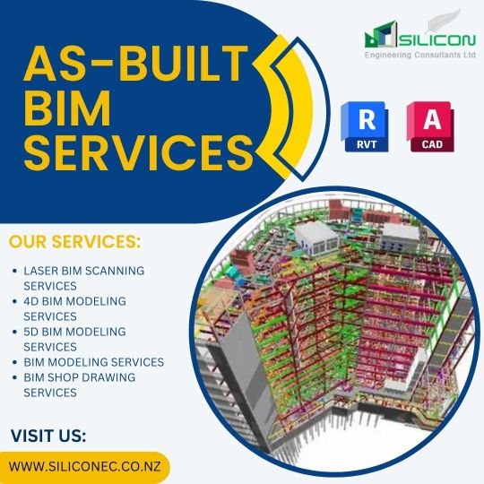
Silicon Engineering Consultants Limited specializes in providing As-Built BIM Services, which is widely recognized as one of the most essential services in the AEC Industries.
#Auckland #Newzealand
bit.ly/45OkEcB
#AsBuiltBIMModeling#LaserScanningServices#AsBuiltToBIMServices#AsBuiltToBIMSolutions#CADDrawing#AECIndustries#CADDesigning#3DLaserScanning#AsBuiltModellingService#AsBuiltBIMOutsourcingServices
1 note
·
View note
Text
Construction Laser Scanning Services
Starting from the planning stages through the final construction and maintenance phases, construction 3D laser scanning is employed throughout the project lifespan.
Improve project efficiency & safety with 3D laser scanning in construction to get analysis and site survey, design and planning, inspection and quality control, project management, upkeep & renovation.
0 notes
Text
🌐 Embrace Precision with iScano Toronto's 3D Laser Scanning Services in Toronto!
Discover the power of 3D construction scanners and experience the excellence of laser scanning. Elevate your projects to new heights. Connect with us today for a complimentary consultation! 📏🔍 Explore the world of #3DLaserScanning, #TorontoConstruction, and #LaserScanners. 🏗️
Read more : https://posts.gle/Vz9pjY
Contact us: iScano Toronto 126 Simcoe Street, Unit 2204, Toronto, Ontario M5H 4E6 (647) 773-1341 https://iscano.com/3d-laser-scanning-toronto/
Visit our online listings: https://bit.ly/3WMJYM2 https://bit.ly/43p0DHW https://bit.ly/3LNhZYc
#3d scanning services#laser scanning#laser scan#3d laser#3d laser scanning services toronto#scanning services#3d laser scanning services#3d construction scanner#laser scanners#youtube
0 notes
Text
3d Scanning Reverse Engineering
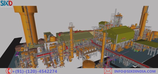
3D scanning is a technique for collecting high-density spatial imaging with millions of coordinates quickly and accurately for your aircraft, vehicle and other large objects. SixD Engineering Solutions Pvt. Ltd. Visit this Link:- http://bit.ly/2n41v5J Phone No : +(91)-(120)-4542274 / 75 Email Id : info[@]sixdindia.com
#3dlaserscanning#3d laser scanning survey#3d laser scanning services#Reverse Engineering Services in India
1 note
·
View note
Text
3D Laser Scanning Company Philadelphia, PA
Our expert architects & engineers ensure quality-assured BIM models for the smooth and streamlined construction and management of residential, commercial, and industrial buildings. We offer the following BIM services such as MEP BIM, 3D Laser Scanning, Scan to BIM, Architectural BIM, Structural BIM, Revit Family Creation, 4D BIM scheduling, 5D BIM cost estimation & Shop Drawings Services in Pennsylvania.
0 notes
Photo
3D laser scanning solutions allows surveyors to provide as-built surveys, which prevent expensive rework by identifying any mistakes early in the design. It is also used to validate the process of design execution for quality assurance.
- Mapping Existing Site Conditions in Renovation Projects - Validating Proper Design Execution - Measure and Evaluate Progress - Creating 3D Building Models
By using laser, advanced scanners create 3D representations known as point clouds. These point clouds contain data that is used to create a map of the precise shape and size of physical objects. For more information about 3D laser Surveying in Building Construction read our latest blog
#3Dlaserscanning#3Dbuildingscanning#laserscanning3dmodeling#laserscanning#3DLaserScanningSurvey#BIMLaserScanning#LiDARScanning#LaserSurveying
0 notes
Text
Revolutionize your construction projects with 3D laser scanning! 🏗️ Get the complete guide to unlock its potential.
0 notes
Text
Fast Track Architectural Surveying with AI-Powered Scan to BIM
Transform architectural surveying with AI-powered Scan to BIM technology. Convert 3D laser scans into precise BIM models for faster project turnaround, reduced costs, and unmatched accuracy. Ideal for surveyors, MEP engineers, and AEC professionals seeking efficiency and a competitive edge in complex projects.
Read More:
0 notes
Audio
Benefits of 3D Laser Scanning for Die Casting
3D laser scanners are assisting companies in performing quick and accurate quality inspections on die-cast parts. Die casting can now provide better outcomes with less labour and more incredible speed because of the development of reverse engineering tools.
https://trevillaengineering.com.au/promising-benefits-of-3d-scanning-for-die-casting/
1 note
·
View note