#anuradhapura district
Explore tagged Tumblr posts
Visit Tumblr Blog
Explore Tumblr blogs with no restrictions, modern design and the best experience.
Last Seen Tumblr Blogs


Fun Fact
25% of US internet users with an annual income of $80-100K use Tumblr.
Text

Rajagala is a heavily forested mountain situated 316 m (1038 ft.) above sea level in Ampara district. It is also known as Rassagala and Rajagalathena. The Rajagala archaeological site consists of over 500 ruins and artifacts of a Buddhist monastery, and is only second to the Mihintale monastery in Anuradhapura. This historically significant UNESCO-protected site spreads over a sprawling area of 300 acres. Photo credit @ajeetsrilanka
4 notes
·
View notes
Text
Anuradhapura district ..sri lanka...tour ..
Visit now...

0 notes
Text
[ad_1] India and Sri Lanka signed several Memorandums of Understanding (MoUs) in the presence of Prime Minister Narendra Modi and Sri Lankan President Anura Kumara Dissanayake in New Delhi on Monday. Addressing a joint press conference following the singing, PM Modi highlighted India’s robust support to Sri Lanka’s development. “India has so far provided 5 billion dollars in line of credit and grant assistance to Sri Lanka. We have cooperation in all 25 districts of Sri Lanka, and the selection of our projects is always based on the development priorities of the partner countries,” he said. He also announced India’s decision to grant assistance for the rehabilitation of the Maho-Anuradhapura railway signalling system and Kankesanthurai Port. PM Modi further detailed new initiatives under India’s developmental cooperation with Sri Lanka. “From next year, monthly scholarships will be given to 200 students in the universities of Jaffna and Eastern Province. In the next five years, 1500 civil servants of Sri Lanka will be trained in India,” he stated. India’s involvement in the sectors of housing, renewable energy, agriculture, dairy, fisheries, and infrastructure development was also emphasised. “India will also participate in the unique digital project in Sri Lanka,” Modi added, underscoring the broadening scope of collaboration. India and Sri Lanka share a relationship that spans more than 2,500 years, rooted in deep civilizational and historical ties. This connection is further strengthened by India’s ‘Neighbourhood First’ policy and its Security and Growth for All in the Region (S.A.G.A.R) vision. The shared cultural heritage and people-to-people exchanges form the bedrock of the bilateral partnership, which encompasses diverse areas such as trade, education, and infrastructure. The Indian-origin community in Sri Lanka, which includes Tamil plantation workers and a smaller population of business-focused professionals, also contributes to the bilateral dynamic. With approximately 1.6 million Indian-origin Tamils and 10,000 People of Indian Origin engaged in commerce and other sectors, these groups act as a bridge between the two nations, fostering socio-economic and cultural connections. [ad_2] Source link
0 notes
Text
Historical places in Sri Lanka
Anuradhapura- Major city Anuradhapura is situated in Sri Lanka's north-central plain. It serves as both the provincial and district capitals of North Central Province and Anuradhapura, respectively. Situated on the banks of the traditional Malwathu Oya, the city is situated in the North Central Province, 205 kilometers (127 miles) north of the present-day capital of Colombo. The city is currently recognized as a World Heritage Site and is well-known for its well-preserved ancient Sinhalese civilization ruins.
Although Mahāvaṃsa dates the city's origin to 437 BCE, the location has been inhabited for much longer; in fact, it is one of the oldest continuously inhabited towns in Asia and a prominent human habitation on the island for over three millennia. It is the birthplace of Theravada Buddhism and the Hydraulic Sinhalese culture. It is also the oldest and most surviving ancient capital of Sri Lanka, dating back more than 1500 years. In addition, it served as the Sinhala Kingdom of Rajarata's first capital after Tambapanni and Upatissa Nuwara. For many centuries, Anuradhapura served as the center of Theravada Buddhism. It is a popular destination for Buddhist pilgrims, and the ruins of numerous ancient Buddhist temples can be found there, including the well-known Anuradhapura Maha Viharaya and the Jaya Sri Maha Bodhi, which is thought to be the oldest living, documented, planted tree in the world and the original branch of the sacred fig tree at Bodh Gaya (Bihar, India), where the Buddha attained enlightenment. The territory of the city is currently around 100 square kilometers (40 sq mi) and is made up of enormous networks of historic temples and monasteries. When the Cholas from South India invaded the city in 993 CE, it was mainly devastated and abandoned. The capital of Anuradhapura was not restored as a significant population hub of the island until the British colonial era in the 19th century CE, despite multiple attempts by succeeding Sinhalese monarchs to do so. The 1870s marked the start of the modern city's serious revitalization. Situated near a railway line, the modern city was mostly relocated in the middle of the 20th century to protect the location of the old capital. It is a prominent crossroads in the northern region of Sri Lanka. The city serves as the headquarters for the Archaeological Survey of Sri Lanka, and tourism plays a big role in the country's economy.
The greatest example of Sri Lanka's pre-modern urbanism may be found in Anuradhapura. The establishment of the first settlement at the city's location can be linked to the second worldwide cycle of historical evolution, which culminated in the rise of several historical civilizations during the first millennium BCE due to the widespread spreading of iron technology in the Old World. After being laid out by Devanampiya Tissa (250–210 BCE), the city was abandoned by the last Anuradhapura kings at the end of the tenth century CE. It was briefly reoccupied in the eleventh century, and some of its most important monuments were restored in the third quarter of the twelfth century. This is the chronological span of Anuradhapura's history.
History of Hatthikucchi Viharaya
Hatthikucchi Viharaya is a ruined ancient temple complex located 3.5 kilometers from the Mahagalkadawala intersection on the Padeniya River on the northern edge of Sri Lanka's North Western Province (Wayamba). The Pali word "Hatthikucchi" (Hatthi = Elephant, Kucchi = Stomach) means "Elephant Stomach." 'ඇත්කුස් වෙහෙර' 'Eth Kus wehera' (Eth - Elephant, Kus - Stomach) is the closest Sinhala word for it. These names came about because of a big rock that looks like an elephant and is located inside the temple complex. The temple complex is one of the nation's oldest Buddhist complexes and is thought to have been constructed by King Devanampiyatissa (307–267 BC). Subsequently, this complex was ignored for a variety of reasons, and by the time King Sirisangabo arrived, it was completely covered in jungle.
It has been acknowledged that King Sirisangabo (251–253 AD) presented a peasant with his head at this site. While it was formerly widely believed that this episode happened in the Gampaha area in Attanagalla, the majority of experts now contend that this is where it happened.
The story's description of the peasant's half-day travel from Anuradhapura towards the south, where he met the former monarch Sirisangabo, served as the primary inspiration for this notion. There is a greater likelihood that Hatthikucchi Viharaya—which is only 38.5 miles from Anuradhapura—is the location of the incident because it is closer than Attanagalla, which is 170 km away.
This is corroborated by the existence of a mausoleum thought to contain King Sirisangabo's remains. Since the headpiece was absent from the deceased body, a granite spherical serves as the headpiece on this gravestone, constructed from bricks resembling human bodies.
There may yet be more ruins at this location hidden by the forest, as excavations are still ongoing.
0 notes
Text
Exploring the 10 Best Temples in Sri Lanka: A Fusion of Spirituality

Sri Lanka is a land where spirituality and architectural brilliance converge in its ancient temples. Embark on a journey through the best temples in Sri Lanka, each offering a unique blend of history, culture, and religious significance. From iconic places to visit in Sri Lanka to hidden gems, these temples showcase the rich heritage of this island nation.
Temple of the Sacred Tooth Relic (Sri Dalada Maligawa), Kandy Discover the revered Temple of the Sacred Tooth Relic, housing the sacred tooth of Buddha. Explore its magnificent architecture and witness traditional rituals that reflect Sri Lanka’s deep Buddhist roots.
Dambulla Cave Temple (Golden Temple of Dambulla), Dambulla Marvel at the Dambulla Cave Temple, a UNESCO World Heritage Site adorned with intricate murals and over 150 Buddha statues. Ascend the rock to experience panoramic views and ancient Buddhist art.
Adam’s Peak (Sri Pada), Ratnapura District Climb the sacred Adam’s Peak, a pilgrimage site revered by Buddhists, Hindus, Christians, and Muslims alike. The summit offers breathtaking views and a profound spiritual experience.
Ruwanwelisaya, Anuradhapura Admire the grandeur of Ruwanwelisaya, one of Sri Lanka’s largest stupas and an architectural marvel from ancient times. Feel the serenity of this sacred site surrounded by ancient ruins.
Gangaramaya Temple, Colombo Visit Gangaramaya Temple, a vibrant urban oasis in Colombo. Explore its eclectic mix of architectural styles, museum, and picturesque temple grounds, reflecting modern Buddhist practices.
Kataragama Temple (Kiri Vehera), Kataragama Experience the religious fervor at Kataragama Temple, where devotees from various faiths gather to pay homage to Lord Kataragama. Witness colorful rituals and processions during festival times.
Munneswaram Temple, Chilaw Discover the Munneswaram Temple dedicated to Lord Shiva and Goddess Parvati. This Hindu temple is renowned for its historical significance and architectural beauty.
Nallur Kandaswamy Kovil, Jaffna Explore Nallur Kandaswamy Kovil, a prominent Hindu temple in the northern city of Jaffna. Admire its intricate Dravidian architecture and participate in traditional rituals.
Kelaniya Raja Maha Vihara, Kelaniya Delve into the history of Kelaniya Raja Maha Vihara, an ancient temple mentioned in Buddhist scriptures. Experience its serene atmosphere and beautiful frescoes depicting Buddhist stories.
Lankatilaka Temple, Kandy Visit Lankatilaka Temple, an architectural gem nestled amidst lush greenery in Kandy. Admire its unique design and intricate carvings, showcasing the ingenuity of Sri Lankan craftsmen.

CONCLUSION-
These temples not only reflect the spiritual beliefs of Sri Lankans but also stand as testaments to the island’s rich architectural heritage. Explore these best temples in Sri Lanka to delve deeper into the soul of this enchanting country.
0 notes
Text
Where is Ravana’s Lanka actually located?
youtube
The historicity of Lord Rama is often questioned on the grounds that there is no archaeological evidence to support that he ever lived or attacked Lanka. It is indeed true that the earliest archaeological evidence of potsherds from Sri Lanka is from around 5th century BCE from Anuradhapura.[i] The time of Lord Rama is considered to be around 2000 BCE.[ii] Therefore, there was no habitation in Sri Lanka at the time when Lord Rama lived let alone evidences of palaces and bridges that are described in the Valmiki Ramayana. Therefore, we have to relocate Lanka to a place where we get archaeological evidence; or we have to accept that Rama was not a historical figure.
What is the connection between Mandore and Ravana?
I was once visiting Mandore near Jodhpur. Ravana’s wife Mandodari is supposed to be the daughter of the king of Mandore. That is how she got her name Madodari. There is a Ravana Chaura here which is said to have been built in the honour of Ravana when he had come to wed Mandodari. Folk tellers from the area said that Ravana had come from Kutch to wed Mandodari.[i] That set me thinking about the location of Lanka somewhere in the Rann of Kutch.
In which direction did Ravana take Sita?
Rama had spent part of his exile at Panchvati near Nashik. Ravana had come to this place and kidnapped Sita and taken her to Lanka. When Rama came to know that Sita had been kidnapped, he asked to deer: in which direction Ravana took Sita? The Valmiki Ramayana says that the deer pointed to the sky and ran keeping their heads in the southern direction.[i] This gives two contradictory signals. If we take the direction of the sky to be important then the deer did not tell off any direction but if we take the keeping their head in the southern direction to be important then it means that Ravana took Sita in that direction. Both possibilities are indicated here and it cannot be said that Ravana took Sita to the south with certainty.
youtube
Where is the Pampa river mentioned in the Ramayana?
Next, the Valmiki Ramayana says that Rama crossed the Pampa by wading into it. Whether Pampa was a reservoir or a river is not clearly indicated because the word used for Pampa is “pushkarini” which can mean either of the two things.[i] North of Nasik there is a place called Pampa Reservoir. It is deep and it is not possible to wade into it. There is a river named Poorna that falls into this reservoir. It is possible at that time the Poorna was known as Pampa and Rama may have waded into the Poorna to cross it as told in the Valmiki Ramayana.
Was Pushpak Vimana actually a ship?
The second instance of the southern direction comes when Rama moves on searching for Sita. He went to Janasthan where he met with Jatayu who told him that Ravana had taken Sita in the southern direction. Now, it seems that Ravana was a seafarer. The description of Pushpak vehicle with large rooms and flags suggests this was a waterborne ship.[i] So, Ravana must have come to Janasthan on the ship. River Godavari that flows south of Nashik flows to the east and there is no possibility that Ravana came here on a ship on this river. The river flowing to the north of Nashik is the Tapti. There is a place named Kamrej on its banks where an ancient port has been discovered.[ii] Ravana appears to have come upstream of the Tapti to Kamrej and then may have taken the land route to Nashik to kidnap Sita.
Now, if this was the case, then Ravana would have followed the south-westward flow of the Tapti to get into the Arabian Sea from Kamrej. This south-western travel of Ravana may have been told by Jatayu to Rama as Ravana having taken Sita in the southern direction.
Where is Kishkindha of Ramayana located?
Not finding Sita at Janasthan, Rama travelled northward with Sugriva to Kishkindha. Here there is a place called Maniknath caves in District Danta. Local people say that this cave was inhabited by demons until Sage Maniknath drove them away.[i] The connection of demons with the place is thus established. These demons may have been the people of Sugriva who is also considered to have been a demon. Importantly, local people believe that Rama had come to Danta before having started the conquest of Lanka.
Hanuman’s journey: Towards south or north-west?
Now the second mention of the southward direction is found in the travels of Hanumana. Rama had sent Hanumana to find Sita. The Valmiki Ramayana says that Hanumana travelled in the southern direction from Kishkindha. The Maniknath cave is located on the sudden flank of a mountain. The road from Maniknath cave proceeds southward. So, Hanumana had to reach Kutch where, as we shall show shortly, Sita was taken by Ravana, from Maniknath then one has to come down from the mountain on the south and then veer around the mountain to go to Kutch. This short southward travel of Hanumana may have been mentioned in the Valmiki Ramayana.
The Ramayana also says that Hanumana left in the Abhijeet Constellation. The direction associated with the Abhijeet Constellation is northwest.[i] Here, again, we have two contradictory signals from the Ramayana. On the one hand it says that Hanumana travelled in the southern direction; on the other hand, it says he travelled in the Abhijeet constellation or the northwest direction. So, can be true–Hanumana may have travelled in the southern or the northwest direction.
Sindhu of Valmiki Ramayana could be the Indus River falling into the Rann of Kutch
Hanumana located Sita at Lanka and came back and reported to Rama. Thren Rama and Sugriva decided to march on Lanka. The Valmiki Ramayana says that their target was to reach the banks of the Sindhu. Now normally it is understood that Sindhu is a synonym for the sea. This is the third mention of the southern direction. But the more direct association is found with the Sindhu River. At the time of Rama at 2000 BCE, the Indus or the Sindhu River was flowing to east to her present course and it was emptying into the Rann of Kutch.[i] Therefore, Rama and Sugriva going to the banks of the Sindhu could be the Rann of Kutch.
A possibility is that they camped at Vadnagar that lies about 50 km to east of the Rann of Kutch. There is a placed called Rama Tekadi. Here some ancient bricks are seen which, to my knowledge, have not been carbon dated yet.
There is also a small temple by the name Rameshwar on the mound which is the place mentioned in the Ramayana as the place where they started making the bridge to Lanka.
There are two islands as one approached the Rann westward from Vadnagar. Then there is a third bigger island known as Khadir on which the ancient site of Dholavira is located. Rama had to cross the sea between these islands. The Hindu texts say that Rama’s army uprooted trees, tied stones to them and threw them in the sea. Such a strategy would be perfect for the shallow Rann of Kutch where the maximum depth is about 20 feet. The stones would sink into the seabed and hold the trees in their position. One could jump from one floating branch to another and cross the sea. This may have been the bridge made by Rama.
Interestingly, before Rama started making the bridge, he had discharged an arrow which he had placed on his bow to threaten the Sea to give him a path to Lanka. The Valmiki Ramayana says that the place where the arrow fell became a hole and it was named “Vrann.”[i] Here we have a clear association of the “Rann” of Kutch and the “Vrann” of the Ramayana. It seems that Rama made the bridge over the Rann of Kutch and reached Dholavira.
What is Dholavira famous for?
The Valmiki Ramayana says that Lanka had manmade reservoirs.[i] In Dholavira we have more than four large manmade reservoirs. There is a place named Lanki Bajar on the island of Khadir. There is a place named Lanki Dungra south of Dholavira on the other bank of the Rann. We have the name Lanka embedded in Lanki Bajar and Lanki Dungra. There are folk tales about Rama having come here.
Rama crossed the Rann, went to Dholavira, fought with Ravana and liberated Sita. Dholavira was inhabited from about 3000 BCE.[i] So, if we consider Rama to have lived at around 2000 BCE, then we get archaeological evidence in support of this being the Lanka. Rama went back to Ayodhya after reclaiming Sita here.
As an aside, the narrative of Rama in the Hindu texts and that of Abraham in the Bible are substantially similar. Rama left southward with his wife and his brother. Abraham left South ward with his wife and his nephew. After reaching south, Rama’s wife Sita was kidnapped by Ravana. After reaching south, Abraham’s wife Sara was taken by the people to the palace of the Pharaoh. Rama retrieved Sita from Ravana after killing him. Abraham was given Sarah back by the Pharaoh. Rama went back to Ayodhya after reclaiming Sita. Abraham went back after getting back Sarah.
In conclusion, the archaeological, geographical, etymological and ethnographic evidences suggest that Lanka could be located at Dholavira. This establishes the historicity of Lord Rama.
Note: To watch the video on YouTube: https://youtu.be/TpetS8-7Jgo
References
[i] Archaeological Survey of India (2013), Excavations – Dholavira, http://asi.nic.in/asi_exca_2007_dholavira.asp, Retrieved July 24, 2013.
[i] Ramayana, Sundar Kanda 2:12.
[i] Ramayana, Yuddha Kanda 22:37-40. I am thankful to Shri R S Bisht for drawing my attention to this verse.
[i] Snelgrove, Alfred K, Migrations of the Indus River, Pakistan, in Response to Plate Tectonic Motions, Journal of Geological Society of India, Vol 30, August 1979, Page 394.
[i] Bangalore Venkat Raman, Prasna Marga, Motilal Banarsidass Publ., 1999, Page 642.
[i] Prabhu Bhai Desai, former Village Headperson of Kunwarsi Village.
[i] The Pushpaka Vimana “is thought to resemble a ship” (Monier-Williams, Monier, Sanskrit-English Dictionary, Southern Publications, Madras, 1987, Page 980).
[ii] Gupta, Sunil, Port structures at early historic Kamrej, 7th National Conference on Marine Archaeology of Indian Ocean Countries : Session 1, CSIR National Institute of Oceanography, Dona Paula, Goa, http://www.nio.org/index/option/com_eventdisplay/task/view/tid/4/sid/114/eid/28, Retrieved March 24, 2016).
[i] The Ramayana uses “Pampa” 3 times with the adjective “Pushkarini” (Ramayana, Aranya Kanda 73:10, 74:1, Kishkindha Kanda 1:1). “Pushkarini” means blue-lotus (Monier-Williams, Sanskrit-English…, Page 638). Thus, “pushkarini” could refer to a pond or a river.
[i] Ramayana, Aranya Kanda 64:16-17.
[i] Tulsi Singh Rathod at Pabuji Temple located between Jodhpur and Phalodi.
[i] Excavation Division, Prehistoric Research Excavations, Department of Archaeology, Sri Lanka, www.archaeology.gov.lk/web/index.php?option=com…id…, 2013, Retrieved July 24, 2013.
[ii] Roy, S B, “Scientific (Astro-Dynastic) Chronology of Ancient India,” in C Margabandhu et. al., Editors, Indian Archaeological Heritage, Agamkala Prakashan, Delhi, 1991, Page 702-703.
#RamayanaJourney#RamaLankaControversy#HistoricalEvidenceravan'slanka#Ravana'sCrossroads#MandoreMystery#PanchavatiTrail#JanasthanRevelation#Jatayu'sInsight#PushpakVimanaRoute#SitaAbductionTheory#KamrejDiscovery#HanumanQuest#ManiknathCave#IndusToLanka#RannOfKutchTrail#DholaviraClues#HistoricalJourneyoframandravan#Youtube
0 notes
Text
Explore the Beauty of Sri Lanka: A Guide to the Best Places to Visit in 2024

Sri Lanka, with its rich history, stunning landscapes, and vibrant culture, is a paradise for travelers seeking adventure and relaxation. From ancient temples to pristine beaches, the island nation offers a wealth of attractions that cater to every taste. In this guide, we'll take you through the best places to visit in Sri Lanka in 2024, highlighting the famous attractions, festivals, foods, things to do, and the best time to visit this beautiful country.
Places to Visit in Sri Lanka:
Sigiriya: Sigiriya, also known as Lion Rock, is an ancient rock fortress located in the central Matale District of Sri Lanka. The fortress is surrounded by lush greenery and offers stunning views of the surrounding landscape.
Kandy: Kandy is a bustling city located in the central province of Sri Lanka. The city is known for its sacred Buddhist sites, including the Temple of the Tooth Relic, which houses a tooth relic of Lord Buddha.
Galle: Galle is a historic city located on the southwestern coast of Sri Lanka. The city is known for its colonial architecture, including the Galle Fort, a UNESCO World Heritage Site.
Nuwara Eliya: Nuwara Eliya is a hill station located in the central province of Sri Lanka. The town is known for its cool climate and picturesque landscapes, making it a popular destination for nature lovers.
Famous Attractions in Sri Lanka:
Adam's Peak: Adam's Peak, also known as Sri Pada, is a sacred mountain located in central Sri Lanka. The mountain is known for its "sacred footprint," which is believed to be the footprint of Lord Buddha.
Yala National Park: Yala National Park is the most visited national park in Sri Lanka. The park is home to a variety of wildlife, including elephants, leopards, and crocodiles.
Dambulla Cave Temple: Dambulla Cave Temple is a UNESCO World Heritage Site located in central Sri Lanka. The temple complex consists of five caves, which are adorned with Buddhist murals and statues.

Festivals in Sri Lanka:
Sinhala and Tamil New Year: The Sinhala and Tamil New Year is a major cultural festival celebrated in Sri Lanka. The festival marks the beginning of the new year and is celebrated with traditional games, rituals, and feasting.
Vesak: Vesak is a Buddhist festival that celebrates the birth, enlightenment, and death of Lord Buddha. The festival is marked by colorful processions, lanterns, and decorations.
Famous Foods in Sri Lanka:
Rice and Curry: Rice and curry is a staple dish in Sri Lanka, consisting of rice served with a variety of curries, including vegetable, fish, and meat curries.
Kottu Roti: Kottu Roti is a popular street food in Sri Lanka, made from chopped roti bread, vegetables, and meat or fish, all stir-fried together with spices.
What Things to Do in Sri Lanka:
Explore the Ancient City of Anuradhapura: Anuradhapura is one of the oldest continuously inhabited cities in the world and is home to a wealth of ancient ruins and temples.
Visit the Tea Plantations: Sri Lanka is famous for its tea, and a visit to the tea plantations in the central highlands is a must-do activity for tea lovers.
Best Time to Visit Sri Lanka:
The best time to visit Sri Lanka is from December to March, when the weather is dry and sunny, making it ideal for exploring the country's attractions and beaches.

Conclusion:
Sri Lanka offers a wealth of attractions for travelers, from ancient temples to pristine beaches and lush tea plantations. Whether you're a nature lover, history buff, or foodie, Sri Lanka has something for everyone. So, pack your bags and get ready to explore the enchanting beauty of this island nation in 2024!
#india tour#Asia tour#Sri Lanka Tour#Sri Lanka tour Guide#Sri Lanka tour Package#Sri Lanka Festival#Sri Lanka places
0 notes
Video
youtube
Cycling around Anuradhapura ancient Buddhist city, Sri Lanka
Anuradhapura is the capital city of North Central Province of Sri Lanka and the capital of Anuradhapura District. Anuradhapura is one of the ancient capitals of Sri Lanka, famous for its well-preserved ruins of an ancient Sinhala civilization. It was the third capital of the kingdom of Rajarata, following the kingdoms of Tambapanni and Upatissa Nuwara.
We hired some bikes and spent a day taking in the sites. This video is a brief overview of some of the highlights.
For more Sri Lanka Shorts, click here for the full playlist: https://www.youtube.com/playlist?list=PLCJEvAhYRazzrptlvLmdYhTUKyv0tihWk
#statue#backpacking#gopro#travel#anuradhapura#buddha#buddhist#ancient buddhist city#cycling#ruins#anuradhapura district#kingdom of Rajarata#abhayagiri dagoba#queen's palace#unesco world heritage site#dagobas#street food#roti#royal palace#sri lanka
0 notes
Text
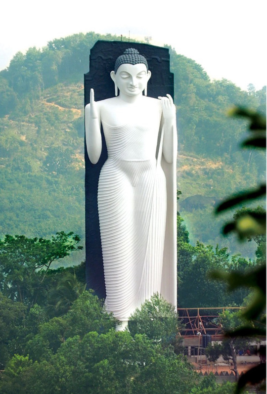
Batamullakanda International Buddhist Centre - Mathugama , SriLanka
Photo credit : srilanka foundation.org
Batamullakanda International Buddhist Centre is situated in Matugama in the Kalutara district. It was built in year 2016 and consists of the tallest standing Buddha statue in South Asia. The Buddha statue stands at a height of 41 m and is based on the historic Aukana Buddha Statue in Anuradhapura.
#travel#travel photography#buddhist temple#tourism#srilanka#attractionsinsrilanka#beautifuldestinations#travel ideas#travel destinations
6 notes
·
View notes
Text

Anuradhapura is a major city in Sri Lanka. It is the capital city of North Central Province, Sri Lanka and the capital of Anuradhapura District. Anuradhapura is one of the ancient capitals of Sri Lanka, famous for its well-preserved ruins of an ancient Sinhala civilization.Also known as City of the kings.
#culture#history#landscape#nature#photographers on tumblr#religion#photography#sri lanka#asianart#travel#visitsrilanka
1 note
·
View note
Text
eight Things To Love About Sri Lanka

koneshwaran
Sri Lanka is a land of exotic islands and calming Buddhist spirituality. It is not an exceptionally major nation and yet it has 8 Unesco World Heritage Sites. Truly a traveler's paradise, the attractive coast and shorelines could entice even the most jaded travelers as well as the plenty of actions that the state has to offer to its visitors make it essential visit spot. Right here are top 8 things to see and to do in Sri Lanka:
1.) Buddhism
Sri Lanka is the oldest frequently Buddhist place as being the religion was introduced in the 2nd Century BC because of the son of India's Ashoka Emperor, the Venerable Mahinda.. The ancient Cave Temples of Dambulla, about 3 hours North from Galle, offer some of the oldest paintings and Buddha statues.
two.) Elephants Safe Haven
Elephants are actually hunted near to extinction for your value of their ivory tusks. Sri Lanka offers a truly stunning wildlife sanctuary for them near to Galle where it is possible to volunteer also. Veterinarians caring for all those majestic animals overlook the Elephant Welfare Project and supply a rich opportunity to learn from their knowledge as well as realize important work with the world's ecosystem.
3.) Tree of Enlightenment
In the third century BC, the founder of Buddhist nuns, Sanghamitta, brought a department from Buddha's Fig tree -aka The Tree of Enlightenment - to Anuradhapura. For 1,three hundred years, this city was the Ceylonese funds but it really was abandoned suddenly in 993 immediately after remaining invaded. This attractive World Heritage Site sits in the middle of dense tropical forests that were impenetrable for many years. Today, its historic palaces, monasteries and monuments surround the sacred Bodhi tree that has developed out of that initial branch and folks are free to visit this sacred piece of land.
four.) Colombo
The money of Sri Lanka is where most travelers come through because it houses the greatest airport. Established in the 5th Century, Colombo was the gateway for trade in between Asia as well as West. Times can certainly be spent on the beach front of Mount Lavinia or visiting some city landmarks such as Gangaramaya Vihara; one of the most stunning Buddhist temple in the region thanks to its brass work and stone carvings. The metropolis also houses Pettah, one of the oldest districts in the metropolis that has now been transformed into a marketplace
five.) Dining
Sri Lankans try to eat with their right hand, never their left, and use both bread or small portions of rice for a 'utensil'. By emptying their plate, one indicates that they are still hungry. so leaving a little quantity of foodstuff in your plate states that one is total. Most residents are vegetarians. However, meat dishes are very easily discovered in most restaurants. Albeit a little nation, every region of the country includes a unique foodstuff lifestyle. Spice levels range from spicy to mild and flavor profiles vary even if a dish sports the same name.
6.) Rural life
In Negombo, a city just north of Colombo, the spirit of living on the water still remains. It is transpierced by canals snaking on for 100 km which locals navigate the same way they do in Southeast Asia. The fishermen living on the lagoon still reside in thatch palm villages and carve out their own canoes on which their livelihood depends. The lagoon also houses the Muthurajawela Marsh Land; a fourteen,826 acre protected mangroves park dwellar to over a hundred ninety species of wildlife.
7.) Orphanages
Often referred to as Children's Homes, Sri Lanka is household to many orphans that love the opportunity to interact with various people. These youngsters are keen to learn and also a joy to work amongst. Unfortunately, many youngsters are abandoned by parents who are simply unable to properly take care of them. A spike in orphans also occurred after the 2004 Tsunami, specially in the kid's homes of Galle and every other coastal town. In this country, many think that sharing is caring which mindset is plainly reflected by working with little ones and seeing for oneself how much they give again in their own ways.
eight.) Beach locations
Unawatuna, Bentota and Induruwa, Arugam Bay and Mirissa are a few of the popular shorelines in Sri Lanka which are popular among travelers. The shorelines are islands in microcosm coupled with colonial townscapes, stilt fishermen, superb wildlife parks and Buddhist shrines and temples. The luxurious hotels and colonial era villas are a delight to stay in also.
References World Heritage Site https://en.wikipedia.org/wiki/World_Heritage_Site
1 note
·
View note
Text
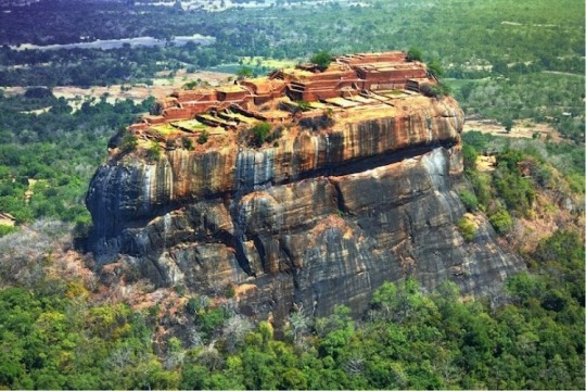

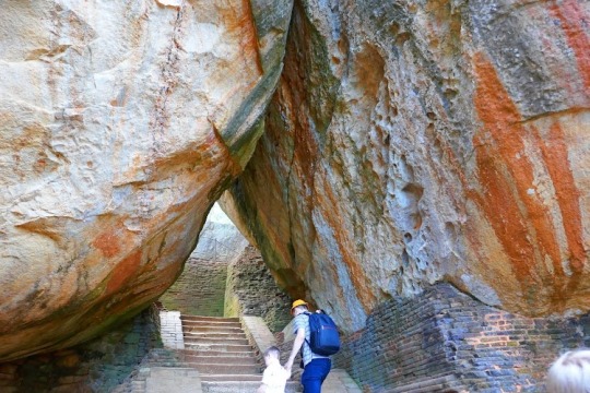

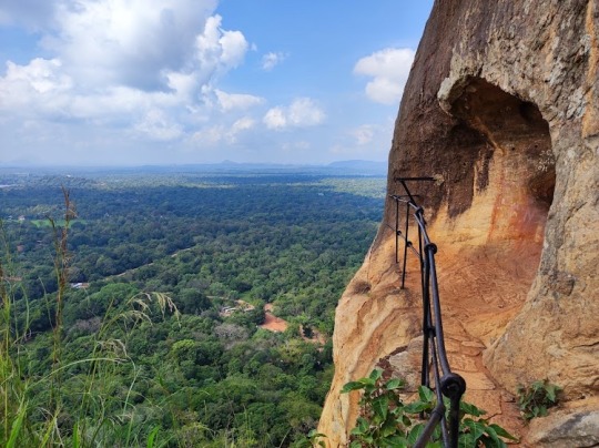

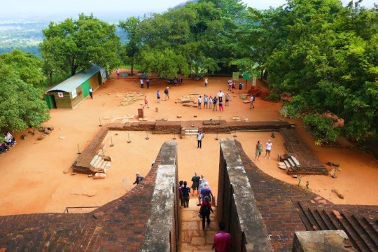
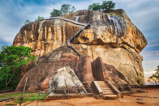
Sigiriya
Sigiriya or Sinhagiri (Lion Rock Sinhala: සීගිරිය, Tamil: சிகிரியா/சிங்ககிரி, pronounced see-gi-ri-yə) is an ancient rock fortress located in the northern Matale District near the town of Dambulla in the Central Province, Sri Lanka. It is a site of historical and archaeological significance that is dominated by a massive column of rock approximately 180 m (590 ft) high.[2]
Sigiriya
Aerial view of Sigiriya Rock
Location
Central Province, Sri Lanka
Coordinates
07°57′25″N 80°45′35″E
Elevation
349 m (1,145 ft)[1]
Built for
King Kashyapa of Sri Lanka
Visitors
1 million
Governing body
Government of Sri Lanka
Website
www.sigiriyafortress.com
UNESCO World Heritage Site
Official name
Ancient City of Sigiriya
Type
Cultural
Criteria
ii, iii, iv
Designated
1982 (6th session)
Reference no.
202
UNESCO Region
Asia-Pacific
Location of Sigiriya in Sri Lanka
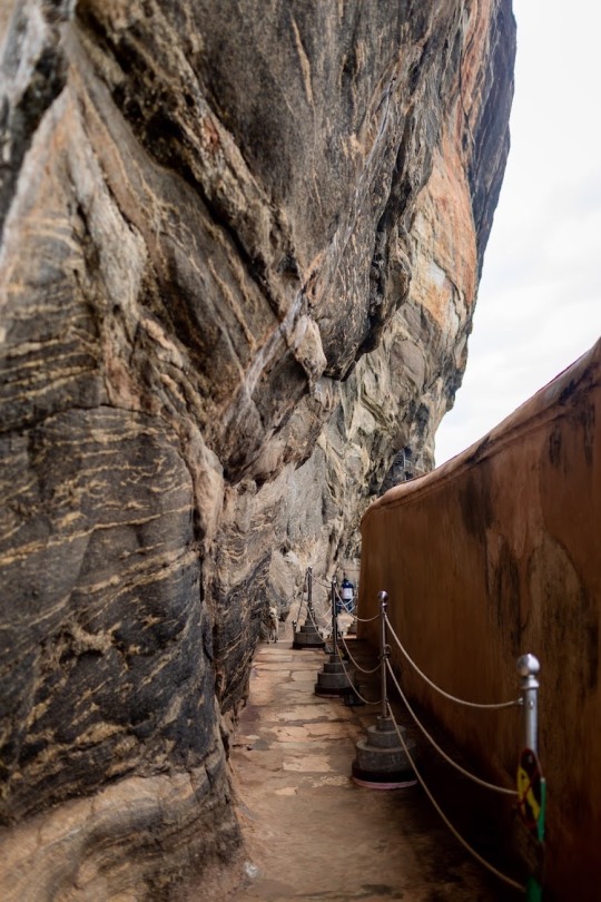
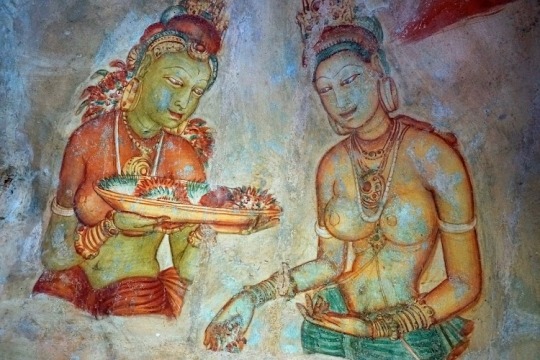
According to the ancient Sri Lankan chronicle the Cūḷavaṃsa, this area was a large forest, then after storms and landslides it became a hill and was selected by King Kashyapa (AD 477–495) for his new capital. He built his palace on top of this rock and decorated its sides with colourful frescoes. On a small plateau about halfway up the side of this rock he built a gateway in the form of an enormous lion. The name of this place is derived from this structure; Sīnhāgiri, the Lion Rock (an etymology similar to Sinhapura, the Sanskrit name of Singapore, the Lion City).
The capital and the royal palace were abandoned after the king's death. It was used as a Buddhist monastery until the 14th century.[3] Sigiriya today is a UNESCO listed World Heritage Site. It is one of the best preserved examples of ancient urban planning.[4]
History
Historical past
It is likely that the area around Sigiriya may have been inhabited since prehistoric times. There is clear evidence that the many rock shelters and caves in the vicinity were occupied by Buddhist monks and ascetics from as early as the 3rd century BC. The earliest evidence of human habitation at Sigiriya is the Aligala rock shelter to the east of Sigiriya rock, indicating that the area was occupied nearly five thousand years ago during the Mesolithic Period.
Buddhist monastic settlements were established during the 3rd century BC in the western and northern slopes of the boulder-strewn hills surrounding the Sigiriya rock. Several rock shelters or caves were created during this period. These shelters were made under large boulders, with carved drip ledges around the cave mouths. Rock inscriptions are carved near the drip ledges on many of the shelters, recording the donation of the shelters to the Buddhist monastic order as residences. These were made in the period between the 3rd century BCE and the 1st century AD.
In 477 AD, Kashyapa I, the king’s son by a non-royal consort, seized the throne from King Dhatusena, following a coup assisted by Migara, the King’s nephew and army commander. The rightful heir, Moggallana, fearing for his life, fled to South India. Afraid of an attack by Moggallana, Kashyapa moved the capital and his residence from the traditional capital of Anuradhapura to the more secure Sigiriya. During King Kashyapa’s reign (477 to 495 AD), Sigiriya was developed into a complex city and fortress.[3][4] Most of the elaborate constructions on the rock summit and around it, including defensive structures, palaces, and gardens, date from this period.
The Cūḷavaṃsa describes King Kashyapa as the son of King Dhatusena. Kashyapa murdered his father by walling him up alive and then usurping the throne which rightfully belonged to his half-brother Moggallana, Dhatusena's son by the true queen. Moggallana fled to India to escape being assassinated by Kashyapa, but vowed revenge. In India he raised an army with the intention of returning and retaking the throne of Sri Lanka, which he considered to be rightfully his. Expecting the inevitable return of Moggallana, Kashyapa is said to have built his palace on the summit of Sigiriya as a fortress as well as a pleasure palace. Moggallana finally arrived, declared war, and defeated Kashyapa in 495 CE. During the battle Kashyapa's armies abandoned him and he committed suicide by falling on his sword.
The Cūḷavaṃsa and folklore inform us that the battle-elephant on which Kashyapa was mounted changed course to take a strategic advantage, but the army misinterpreted the movement as the king's having opted to retreat, prompting the army to abandon him altogether. It is said that being too proud to surrender he took his dagger from his waistband, cut his throat, raised the dagger proudly, sheathed it, and fell dead. Moggallana returned the capital to Anuradhapura, converting Sigiriya into a Buddhist monastery complex,[5] which survived until the 13th or 14th century. After this period, no records are found on Sigiriya until the 16th and 17th centuries, when it was used briefly as an outpost of the Kingdom of Kandy.
<img src="//upload.wikimedia.org/wikipedia/commons/thumb/1/1f/Sigiriya_Luftbild_%2829781064900%29.jpg/450px-Sigiriya_Luftbild_%2829781064900%29.jpg" decoding="async" width="450" height="253" class="thumbimage" data-file-width="3241" data-file-height="1820">
Sigiriya Rock from above
Alternative stories have the primary builder of Sigiriya as King Dhatusena, with Kashyapa finishing the work in honour of his father. Still other stories describe Kashyapa as a playboy king, with Sigiriya his pleasure palace. Even Kashyapa's eventual fate is uncertain. In some versions he is assassinated by poison administered by a concubine; in others he cuts his own throat when deserted in his final battle.[6] Still further interpretations regard the site as the work of a Buddhist community, without a military function. This site may have been important in the competition between the Mahayana and Theravada Buddhist traditions in ancient Sri Lanka.
In Professor Senarath Paranavithana's book The Story of Sigiriya, King Dathusena is said to have taken the advice of the Persian Nestorian Priest Maga Brahmana on building his palace on Sigirya. According to Paranavithana, during this period over seventy-five ships carrying Murundi soldiers from Mangalore arrived in Sri Lanka and landed in Chilaw to protect King Dathusena, most of them Christians. King Dathusena's daughter was married to Migara, a Christian and the commander of the Singhalese army
0 notes
Photo

▶️ Muslim Nikah ▶️ * MOOR FAMILY LOOKING FOR A GROOM* 90500 ***************************************************** Bride Details. ______________ ▪️Age : 23 ▪️Date of birth : 1998.01.31 ▪️Marital Status : Unmarried ▪️Height : 5.3’ ▪️Weight : 65KG ▪️Complexion : Fair ▪️Dress Code : Habaya and Shalwar ▪️Home Town : Kekirawa ▪️Family Status : Middle ▪️School Attended : - ▪️Educational & Professional qualifications : HND In English completed, BEd (R) ▪️Other Skills : Leadership management and Researcher ▪️Occupation : Teacher Trainee (Hope a government teaching soon) ▪️Father's Details : Teacher ▪️Mother's Details : House Wife ▪️Siblings : 3 Brothers and 2 sister ▪️Expected Groom: Unmarried, Educated ( Preferably a degree holder) within Anuradhapura district or Suburbs (Polannaruwa, Matale) *Contact :* Aunty - 0741622217 Please send us your Nikah details to our Muslim Nikah (WhatsApp only) 💬+94762677723 https://www.facebook.com/bridescentralprovince/ (at Kekirawa) https://www.instagram.com/p/CWSyc-5I_xw/?utm_medium=tumblr
0 notes
Photo

8.274355°N, 80.707422°E Anuradhapura district, North Central Province, Sri Lanka photo by harshana jayarathna — Galenbindunuwewa Central College
2 notes
·
View notes