#Southwest Basins and Ranges
Explore tagged Tumblr posts
Visit Tumblr Blog
Explore Tumblr blogs with no restrictions, modern design and the best experience.
Last Seen Tumblr Blogs


Fun Fact
China blocked Tumblr because of pornography and censorship problems in 2013.
Video
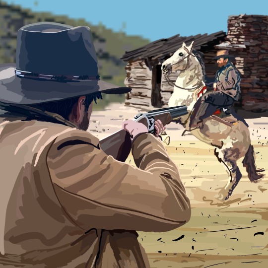
To Stand in Wonder in Carlsbad Caverns National Park by Mark Stevens Via Flickr: Big Room Trail-44 An image captured while walking the Big Room Trail in Carlsbad Caverns National Park with a view towards an amazing display of underground formations.
#Big Bend and Carlsbad Caverns National Parks#Big Room#Big Room Trail#Carlsbad Cavern#Carlsbad Caverns#Cave#Cave Formation#Cavern#Caverns#Day 6#DxO PhotoLab 5 Edited#Guadalupe Mountains#Intermountain West#Landscape#Landscape - Scenery#Large Limestone Chamber#Limestone Cave#Limestone Chamber#Mineral Deposit#Nature#Nikon D850#No People#Project365#Rock Formation#Rock Formations#Scenics - Nature#Show Cave#SnapBridge#Southwest Basins and Ranges#Speleology
2 notes
·
View notes
Text
So I just wanna talk about this and the Sea of the Castout for a sec:

Here's the Sea of the Castout and its surroundings on the map:

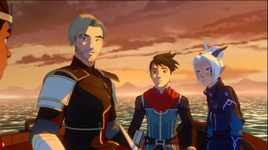
We have the Sparklepuff Squad coming from the north down one of the rivers (red arrows), and the Dragang coming from either the east... or there is a slight possibility that Finnegrin, not having any particular urgency about getting there, chose to go all the way around the Far Reaches to give Callum some time to think things over.
(Could he have taken it even slower and gone all the way around to enter past the ruins of Elarion, thereby putting the statues of Aaravos and the Merciful One there? My opinion is that at that point Sea Legs would have to be going fast enough that the speed would be hard to ignore. The Ruthless is similar to a sloop and so would probably have a normal cruising speed of around 6-8 mph. Sea Legs can supposedly go faster than that, but sailing around to approach the Sea of the Castout from the southwest would add like... rough estimate 100 miles or more to the trip, so either they take an entire day or more doing only that or Sea Legs is going at constant top speed and that speed is really fucking fast.)
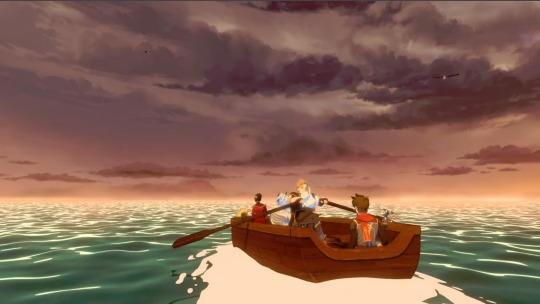
As the Dragang make their way into the Sea, we can still see the rocky horizon behind them, but not ahead:
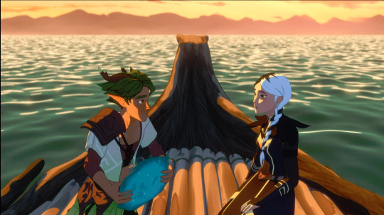
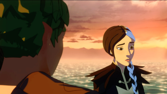
Claudia and Terry, however, can see the shoreline in at least three directions from the center:

We also cannot see the opposite shore when Claudia enters the water:

Assuming you can see the same distance in Xadia as you can here on earth (which is a big assumption, but also a reasonable one to make), that's about 3 miles—as in, the furthest away you can see something as tall as you are before the curvature of the earth obscures it is about 3 miles. However, the rocky sides of the Sea of the Castout are a lot taller than any of the characters, so they can be seen from further away. Based on extremely unscientific googling, the Sea of the Castout is probably in the range of 20-30 miles-ish across, which is consistent with the fact that it's around the same size on the map as the distance between Katolis castle and the Moon Nexus, and that's a reasonable distance for the trio to have gone in the time it takes them to get there.
We also have a shore that looks like this oh god don't look too closely at it, that's a horrible render:
Now, you may consider how much of the edges of the Sea of the Castout appears to be mountainous, then look at the map again and wonder what the hell is going on. Well, first of all, those aren't mountains.
The basin of the Sea of the Castout was presumably created by a catastrophic impact. If it's based visually on a real place, I'd bet it's somewhere like Crater Lake in Oregon:
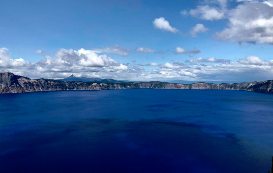
Crater Lake is a volcanic crater, not an impact crater, but same concept applies: instead of being a natural point of low elevation in the landscape, it's a reservoir that was violently punched out of the ground. That elevated rocky horizon isn't mountains, it's the edge of the hole. Crater Lake is quite a bit smaller than the Sea of the Castout probably is (only 5-6 miles across), but the elevation between its surface and the caldera rim is about 1,000 feet, which looks plenty high.
Impact crater lakes do exist, of course, but they tend to be either a lot smaller or a lot older. On earth, all the impact craters the size of the Sea of the Castout are hundreds of millions of years old. Lakes formed in older craters are also more likely to have connected with the surrounding water features, similar to the Sea of the Castout. Crater Lake is less than 10,000 years old and not connected to any rivers or other lakes (unsurprising, given that it used to be the top of a mountain).
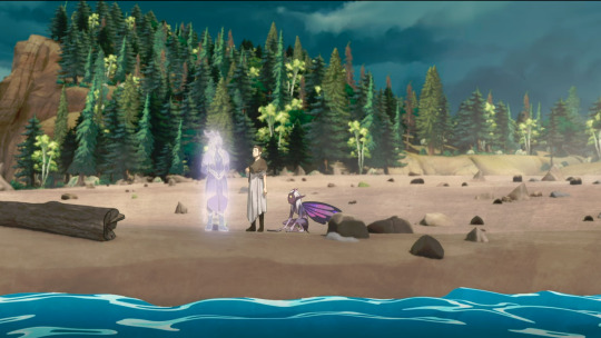
So yeah, it's absolutely possible that Aaravos is at the Sea of the Castout. But let's take a look at the opening:

Yes, that's definitely the same place as Aaravos. Is it literally the Sea of the Castout? Well, the thing is that every other time we see this place, it's in a very... metaphorical or symbolic context. Like the opening. Or here:

Or here:


We also have that Aaravos is kneeling practically on the surface:

Which suggests that either the "OG Aaravos was gigantic" theory is correct, or this is not a normal place where water and lakes behave normally. I'm not a huge (ha) fan of the giant Aaravos theory, but as I've said before... if I had a nickel for every Aaravos-related thing we all assumed was metaphorical but turned out to be literal, I'd have etc.
Basically, this is definitely a place that is connected to the Sea of the Castout thematically and possibly magically, but I don't think Aaravos is literally kneeling in the literal Sea of the Castout on the mortal plane of Xadia.
After all, where do the fabled Great Ones hide?
#i spent a lot of time looking up lakes of various sizes for this#and then i saw crater lake and was like 'OH'#anyway#aaravos#the dragon prince#geography of xadia#kradogsmeta
131 notes
·
View notes
Photo
BIG NEWS IN SALAMANDER TAXONOMY!
Unraveling Siren (Caudata: Sirenidae) systematics and description of a small, seepage specialist
Fedler, Enge, and Moler
Abstract
For approximately four decades, scientists have known of the existence of several undescribed species of Siren in the southeastern United States Coastal Plain.
One of these species, S. reticulata, was recently described, but a small, seepage-dwelling species has remained undescribed until now.
To resolve outstanding questions concerning the phylogeny of Siren, we collected sequence and morphometric data from specimens across the range of Siren.
We found S. lacertina and S. reticulata to represent strongly supported monophyletic groups, with S. reticulata having a sister relationship to all other Siren. Additionally, we found five distinct mtDNA lineages within what has been recognized as S. intermedia. Siren lacertina and type-locality S. intermedia (lineage A) are sister mtDNA lineages, whereas S. intermedia lineages B and C show a high level of mitogenomic divergence from type-locality S. intermedia.
Analyses of two scnDNA loci revealed that S. lacertina is monophyletic but nested with low positional support in a clade including the three S. intermedia mtDNA lineages. Further study is needed to determine whether S. intermedia lineages A, B, and C represent distinct species or incompletely sorted lineages.
We restrict the range of S. intermedia to the region from the Escambia and Perdido river drainages of Florida and Alabama eastward through Virginia (the combined ranges of lineages A, B, and C).
We also elevate S. i. nettingi (lineage E) to species status and include the larger S. i. texana form in that taxon, generating a species that occurs from the Mobile Bay drainages westward through the Mississippi Basin and southwest into northeastern Mexico.
Lastly, we describe a new miniature species, S. sphagnicola, that ranges from the Florida Parishes of Louisiana eastward to the westernmost tributary creeks of Choctawhatchee Bay in the western Florida panhandle.
Read more here:
https://mapress.com/zt/article/view/zootaxa.5258.4.1
224 notes
·
View notes
Text
Lonesome highway across San Augustin Plains. The plains extend roughly northeast-southwest, with a length of about 55 miles and a width varying between 5–15 miles. The basin is bounded on the south by the Luera Mountains and Pelona Mountain (outliers of the Black Range); on the west by the Tularosa Mountains; on the north by the Mangas, Crosby, Datil, and Gallinas Mountains; and on the east by the San Mateo Mountains.
#roadtrip#travel#daytrip#vacation#NewMexico#ranching#cattlecountry#OptOutside#nature#landscape#geology#whataview#remote#offthebeatentrack#leavenotrace#lonesomehighway#video#lovenm#New Mexico
32 notes
·
View notes
Photo

Weather: Pacific Northwest
Report generated at 2024-12-25 16:00:10.377378-08:00 using satellite imagery and alert data provided by the National Weather Service.
Winter Storm Warning
WA:
Central Chelan County
Lower Slopes of the Eastern Washington Cascades Crest
Okanogan Highlands
Okanogan Valley
Olympics
Upper Slopes of the Eastern Washington Cascades Crest
Waterville Plateau
Wenatchee Area
West Slopes North Cascades and Passes
West Slopes North Central Cascades and Passes
West Slopes South Central Cascades and Passes
Western Chelan County
Western Okanogan County
ID:
Bear River Range
Big Hole Mountains
Big Lost Highlands/Copper Basin
Blackfoot Mountains
Caribou Range
Centennial Mountains/Island Park
Franklin/Eastern Oneida Region
Marsh and Arbon Highlands
Raft River Region
Sawtooth/Stanley Basin
Southern Hills/Albion Mountains
Sun Valley Region
Teton Valley
Wood River Foothills
Winter Weather Advisory
WA:
Cascades of Lane County
Cascades of Marion and Linn Counties
North Oregon Cascades
Northeast Mountains
Northern Blue Mountains of Oregon
Northwest Blue Mountains
South Washington Cascades
Upper Columbia Basin
OR:
Baker County
Cascades of Lane County
Cascades of Marion and Linn Counties
East Slopes of the Oregon Cascades
North Central and Southeast Siskiyou County
North Oregon Cascades
Northern Blue Mountains of Oregon
Northwest Blue Mountains
Siskiyou Mountains and Southern Oregon Cascades
South Central Oregon Cascades
South Central Siskiyou County
South Washington Cascades
Upper Weiser River
Western Siskiyou County
ID:
Arco/Mud Lake Desert
Baker County
Bear Lake Valley
Beaverhead/Lemhi Highlands
Boise Mountains
Camas Prairie
Central Panhandle Mountains
Eastern Magic Valley
Frank Church Wilderness
Lost River Range
Lower Snake River Plain
Northern Clearwater Mountains
Northern Panhandle
Shoshone/Lava Beds
Southern Clearwater Mountains
Upper Snake River Plain
Upper Treasure Valley
Upper Weiser River
West Central Mountains
Western Magic Valley
CA:
Greater Lake Tahoe Area
Lassen-Eastern Plumas-Eastern Sierra Counties
Mono
North Central and Southeast Siskiyou County
Northern Trinity
Siskiyou Mountains and Southern Oregon Cascades
South Central Oregon Cascades
South Central Siskiyou County
West Slope Northern Sierra Nevada
Western Plumas County/Lassen Park
Western Siskiyou County
NV:
Greater Lake Tahoe Area
Northern Elko County
Ruby Mountains and East Humboldt Range
South Central Elko County
Southwest Elko County
Coastal Flood Warning
WA:
Central Coast
Coastal Flood Advisory
WA:
Eastern Strait of Juan de Fuca
North Coast
South Washington Coast
Western Strait of Juan De Fuca
High Surf Advisory
WA:
Central Coast
North Coast
South Washington Coast
OR:
Central Coast of Oregon
Clatsop County Coast
Tillamook County Coast
CA:
Catalina and Santa Barbara Islands
Coastal Del Norte
Coastal North Bay Including Point Reyes National Seashore
Los Angeles County Beaches
Malibu Coast
Mendocino Coast
Northern Humboldt Coast
Northern Monterey Bay
San Diego County Coastal Areas
San Francisco
San Francisco Peninsula Coast
San Luis Obispo County Beaches
Santa Barbara County Central Coast Beaches
Santa Barbara County Southeastern Coast
Santa Barbara County Southwestern Coast
Southern Monterey Bay and Big Sur Coast
Southwestern Humboldt
Ventura County Beaches
High Wind Warning
WA:
Admiralty Inlet Area
Central Coast
Clatsop County Coast
North Coast
San Juan County
South Washington Coast
Western Skagit County
Western Whatcom County
Willapa Hills
OR:
Central Coast of Oregon
Central and Eastern Lake County
Clatsop County Coast
Curry County Coast
Modoc County
Northern and Eastern Klamath County and Western Lake County
South Central Oregon Coast
South Washington Coast
Tillamook County Coast
ID:
Orofino/Grangeville Region
CA:
Central and Eastern Lake County
Coastal Del Norte
Modoc County
Northern and Eastern Klamath County and Western Lake County
Wind Advisory
WA:
Admiralty Inlet Area
Bellevue and Vicinity
Bremerton and Vicinity
Central Panhandle Mountains
Coeur d'Alene Area
East Puget Sound Lowlands
Everett and Vicinity
Foothills of the Blue Mountains of Washington
Foothills of the Northern Blue Mountains of Oregon
Hood Canal Area
Idaho Palouse
Lower Chehalis Valley Area
Lower Garfield and Asotin Counties
San Juan County
Seattle and Vicinity
Southwest Interior
Spokane Area
Tacoma Area
Upper Columbia Basin
Washington Palouse
Western Skagit County
Western Whatcom County
OR:
Central Oregon
Eastern Curry County and Josephine County
Foothills of the Blue Mountains of Washington
Foothills of the Northern Blue Mountains of Oregon
Foothills of the Southern Blue Mountains of Oregon
Grande Ronde Valley
Jackson County
North Central Oregon
ID:
Central Panhandle Mountains
Coeur d'Alene Area
Idaho Palouse
Lewis and Southern Nez Perce Counties
Spokane Area
Washington Palouse
CA:
Central Siskiyou County
Del Norte Interior
Greater Reno-Carson City-Minden Area
Interstate 5 Corridor
Northern Humboldt Coast
Northern Humboldt Interior
Northern Ventura County Mountains
Northern Washoe County
Santa Barbara County Interior Mountains
Santa Barbara County Southwestern Coast
Santa Ynez Mountains Eastern Range
Santa Ynez Mountains Western Range
Southern Humboldt Interior
Southern Ventura County Mountains
Southwestern Humboldt
Surprise Valley California
NV:
Greater Reno-Carson City-Minden Area
Northern Washoe County
Surprise Valley California
Hydrologic Outlook
WA:
Grays Harbor
Flood Watch
WA:
Clallam
Flood Warning
WA:
Mason
High Surf Warning
OR:
Curry County Coast
South Central Oregon Coast
Lake Wind Advisory
NV:
Western Nevada Basin and Range including Pyramid Lake
4 notes
·
View notes
Text
In the 1880s Apache Country, below the Mogollon Rim of Arizona a combination of events involving cattle rustlers, sheep herders, outlaws, cowboys, sharp shooters, Mormons, mountain lions, Confederates, half Indians, hooded vigilantes, lawmen, and Wild West legends culminated in the largest, most violent, and most unbelievable vendetta, feud, and range war in all of American history. This is the story of the Pleasant Valley War aka the Graham Tewksbury Feud aka the Tonto Basin War that would consume over 50 victims. It’s cinematic, heroic, tragic, and often times unbelievable. It’s filled with out-of-this-world characters, important themes, and jaw dropping, melodramatic, heartbreaking Wild West anecdotes.
15 notes
·
View notes
Text
Geography of Japan:
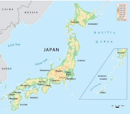
Japan is bounded to the west by the Sea of Japan (East Sea), which separates it from the eastern shores of South and North Korea and southeastern Siberia (Russia); to the north by the La Perouse (Sōya) Strait, separating it from Russian-held Sakhalin Island and by the Sea of Okhotsk; to the northeast by the southern Kuril Islands (since World War II under Soviet and then Russian administration); to the east and south by the Pacific; and to the southwest by the East China Sea. The island of Tsushima is located between northwestern Kyushu and southeastern South Korea, defining the Korea Strait on the Korean side and the Tsushima Strait on the Japanese.
youtube
The country's mountainous character is the result of orogenic (mountain-building) factors that occurred mostly during the Quaternary period (approximately the last 2.6 million years), as demonstrated by the regular occurrence of strong earthquakes, volcanic activity, and indicators of sea level fluctuation along the coastline. There are no significant structural plains or peneplains (huge land expanses levelled by erosion), which are often found in more stable parts of the Earth. The mountains are mostly at an early stage of dissection, with steep slopes punctuated by extensive river-valley networks. Rivers are typically torrential, and their valleys are accompanied by a sequence of river terraces formed by movements in the Earth's crust, as well as climate and sea-level variations over the Holocene (the last 11,700 years). Recent volcanoes are paired with older, more dissected ones. The beaches are distinguished by raised and depressed features such as headlands and bays, which are still in their early stages of development. The mountains are broken into several tiny land units separated by plains or deep saddles; there is no large, continuous mountain range. These land blocks are the consequence of significant faulting (movement of nearby rock masses along a fracture) and warping (bending of the Earth's crust), with the former being the main process. As a result, mountain blocks are frequently surrounded by fault scarps and flexure slopes that drop in steps to the nearby lowlands. Coalescing alluvial fans, or conical deposits of alluvium that run together, arise where rivers emerge from the highlands. When rivers reach the sea, low deltaic plains form in front of fans. This is especially common in shallow and protected bays like Kantō (Kwanto), Nōbi, and Ōsaka. In most locations, however, fan surfaces plummet down into the sea, divided only by short, sandy beach ridges. Dissected plains are commonplace. Disturbances have risen old alluvial fans, deltas, and sea bottoms, resulting in flat-topped uplands like the Kantō Plain. Volcanic ash often covers the uplands, as seen in the Kantō and Tokachi plains.
youtube
Japan is one of the world's most geologically unstable regions. The country suffers over 1,000 tremors each year, most of which are small. However, severe earthquakes, like as those in Tokyo-Yokohama in 1923 and Kōbe in 1995, result in significant loss of life and massive devastation. Violent volcanic eruptions are common, and at least 60 volcanoes have been active throughout history. Shōwa Volcano on Hokkaido and Myōjin Rock off the Beyoneisu (or Bayonnaise) Rocks in the Pacific are examples of volcanoes formed around 1900. Major eruptions after 1980 include Mounts O (1983) and Mihara (1986) in the Izu Islands, as well as Mount Unzen (1991) in Kyushu. The country's plentiful hot springs are largely volcanic in nature. Many of the massive volcanoes are conical in appearance (such as Mount Fuji), while others produce steep lava domes (such as Mounts Dai and Unzen). There are few prominent shield volcanoes (wide, gently sloping volcanic cones), and there are no large lava plateaus. Calderas (huge, circular, basin-shaped volcanic depressions) are common in volcanic areas, particularly in the northeast and southwest, with many of them filled with water, including Lakes Kutcharo, Towada, and Ashi. The instability—and, in fact, the basis for Japan's existence—is caused by the tectonic movement of many of the Earth's major crustal plates near the archipelago. The most significant is the subduction (sinking) of the Pacific Plate (in the north) and the Philippine Plate (in the south) beneath the Eurasian Plate, on which Japan rests. The movements of these plates have formed six mountain arcs off Asia's northeastern coast: the Chishima Range of the Kuril Islands, the Karafuto (Sakhalin) Mountain system of Hokkaido, the Northeast, Southwest, and Shichito-Mariana ranges of Honshu, and the Ryukyu Island formations.
Reference:
The Editors of Encyclopaedia Britannica. (1998). Japan's Land. [Online]. britannica. Last Updated: 27 October 2023. Available at: https://www.britannica.com/place/Japan/Geologic-framework [Accessed 19 February 2024].
2 notes
·
View notes
Text
Discovery of Carasobarbus Sublimus in Al-Diwaniya River, Iraq

Abstract
During a fish survey from 2016 to 2017, we captured 83 specimens of the cyprinid fish, Carasobarbus sublimus from the Al-Diwaniya River, Middle Euphrates, Iraq. This is the first report of the occurrence of this species in this locality. Fish were captured by gill nets and electro-fishing equipment. Twenty two morphometric and eleven meristic measurements were applied to describe the species. The range of total length in the present specimens (130.4-250.1mm) is larger than the range quoted for C. sublimus. The indices characters to standard length (SL) varied from 7.4 % to 121.0 %, and the head characters to head length (HL) from 27.4% to 93.2%. The growth rate between body characters and SL varied from 0.085 to 1.118 and between head characters and HL from 0.210 to 1.091.The numbers of scales in lateral line and around the least circumference of the caudal peduncle are 27-29 and 12, respectively. The biometric data were successful in identifying of C. sublimus and confirm the presence of the species in the Al-Diwaniya River. This is the second record of the species in the Iraqi freshwaters. Based on this finding, the case would be interesting and open to discussion about the distributions of C. sublimus in the Tigris-Euphrates basin.

Introduction
According to Borkenhagen and Krupp (2013), the cyprinid genus Carasobarbus Karaman, 1971 (the himri) belong to the family Cyprinidae, subfamily Barbinae are distributed across southwest Asia and northwest Africa. They occur in all major river systems of the Levant, Mesopotamia, southern Iran, western and south-western Arabian Peninsula and in northern Morocco.
Also, Borkenhagen and Krupp (2013) revised and expanded Karaman’s (1971) diagnosis of the genus that now contains the nine following species: Carasobarbus apoensis, C. canis, C. chantrei, C. exulatus, C. fritschii, C. harterti, C. kosswigi, C. luteus and C. sublimus.

Three species from the genus, C. luteus, C. kosswigi and C. sublimus have been reported from Iranian waters (Borkenhagen and Krupp, 2013) and C. chantrei, C. kosswigi and C. luteus from Turkish waters (Çiçek et al., 2015), while C. luteus, C. kosswigi and C. sublimes were found in Iraqi waters (Coad, 2010; Mohamed et al., 2017).
C. sublimus was first described and reported by Coad and Najafpour in 1997 from Khuzestan waters, southwestern Iran. C. sublimus formerly placed in the genus Kosswigobarbus Berg, 1916, but Borkenhagen et al. (2011) placed this species in Carasobarbus.
Coad and Najafpour (1997) and Esmaeil et al. (2006) have rectified the species by comparing it with C. kosswigi and C. luteus on the basis of their morphology in Iran, while, Mohamed et al. (2017) described and compared C. sublimus obtained from the Shatt Al-Arab River for the first time in Iraq with C. luteus in Iraqi waters.
During the ichthyofauna survey for the Al-Diwania River (a branch from the Euphrates River, middle of Iraq) during November 2016 - October 2017, several specimens of cyprinid fish, C. sublimus have been caught for the first time from south the Daghghara barrier on this river.
The predominant vegetations on the both banks of this locality were reed, Phragmites australis and cattail, Typha domingensis, whereas hornwort, Ceratophyllum demersum was dominant in the deeper areas.
The water temperature of the river varied from 10.2oC in March to 32.8oC in August, dissolved oxygen fluctuated from 5.0mg/l in August to 9.6mg/l cm in February, salinity values ranged from 0.55‰ in April to 0.79‰ in October (Mohamed and Al-Jubouri, 2017).
So, the purpose of this paper is to describe the morphometric and meristic characters of C. sublimus for the first time in the middle of Iraq. Examined specimens had been placed in the fish collection of the Department of Pathology, College of Veterinary Medicine, Al-Qasim Green University, Iraq.
Source Occurrence of cyprinid fish, Carasobarbus sublimus in the Al-Diwaniya River, Middle Euphrates, Iraq
2 notes
·
View notes
Text
Wandlore: Tamarix ramosissima, AKA: Tamarisk, or Salt Cedar.
The science:


The Tamarisk, also called the Salt Cedar, is a shrubby, red barked tree native to some parts of Eurasia and Northern Africa. Tamarisk is known for sapping salt up from any water source near it into the soil around it, as its one of the only plants capable of surviving and thriving under those conditions. In the spring, it blooms a magenta, almost lilac pink in many places.
The Tamarisk tree was introduced to the Colorado River Basin in the late 1800s in an effort to stop soil erosion and keep trails clean. Unfortunately, the Tamarisk tree is Rhizomous, which means it can spread underground as well as through seed, and cuttings or fallen limbs from the tree can also root themselves. Accompanied by its tendency to increase the PH of the soil it lands in, the Tamarisk tree became a rapid menace to the southwestern ecosystem.
Because of this, if you take a river raft down the Colorado you are more than likely going to see hundreds or thousands of these trees along the banks. Places where native Cottonwoods or Willows would normally be are filled to the brim with salty earth and red tamarisk trees.
Luckily, there is a small glimmer of hope. The tamarisk beetle, a small golden yellow weevil, no bigger than the head of a pin, eats exclusively tamarisk trees. Careful introduction of the tamarisk beetle to these trees has begun to curb their expanse. Unfortunately, there are still precious few plants that can survive the salty soil the trees leave in their wake, and the thousands of dead trees alongside the river feel an awful lot like walking through a Grove of ghosts.
Ethnobotany and Mythology:
The tamarisk tree has a vast and ancient set of mythological and religious symbolism behind it. In its native range, the tamarisk tree has long been connected to death and rebirth through the story of Osiris's death in Egyptian paganism. When Osiris is killed, his body is hidden inside the trunk of a massive tamarisk tree, for Isis to find and revive.
This connection to hidden things is also noteworthy, as in the Iliad, Odysseus and diomedes hide some of their spoils from the war inside a Tamarisk. In another Greek myth, a young woman or girl is turned into a Tamarisk tree, along with her siblings. However, it should be noted that many diffrent women, girls, nymphs and goddesses turn into trees, plants and shrubs in mythology, and they are often mixed with each other at one point or another.
In abrahamic religions, many characters are said to gain important knowlage under tamarisk trees ( such as the ever present abraham) or have been buried underneath them (Samuel)
In Islam, they take on a more spiteful turn, as Allah converts the gardens of the saba people to Tamarisk and bitter fruits as punishment.
In the southwest, where they have taken root, they symbolize that same sort of spite as well as a stubbornness for life.
In both their native and invasive ranges, the tamarisk tree is used for making sturdy and durable goods. Things like furniture, wagon wheels, and boxes. The wood itself is beautiful, if occasionally difficult to work with. Medicinally, the tree has been used in traditional practices to treat digestive issues, gut problems, diabetes and dental issues to varying degrees of success. It has also been used in soaking and purifying baths well into ancient times, as its mentioned that gilgamesh's mother took a bath in a Tamarisk soak before sending her son and his partner on their quest.
The magic
Taking all of these sources into account, it's safe to say that the tamarisk tree would have a very specific arcane niche to fill: stubbornness, secrets, and toxicity. The protective aspects of the tree are numerous of course, but often come in unexpected ways. Wands or other foci made with Tamarisk would likely do an average job with standard protective magics, but astonishingly well at protecting those who are already dead, or secrets that one would wish to hide for eternity. These Foci will aslo do an excellent job with purifying Charms and intense purification rituals, perhaps even exorcism if done correctly.
It should also be noted that the high salt content of the Tamarisk tree is two fold: it will aid in its protectiveness, of course, but it may also be a sign that the owner of the foci in question may drive others away in their personal lives. They will be steadfast and stubborn, and good at what they set themselves to task over, but God's forbid they form a true lasting relationship with anyone who isn't exactly like them. This may present itself as a mild sort of closed mindedness at best, or outright hatred of others at worst. They may be xenophobic, religious zealots, or even simply abrasive. This isn't to say every person who possesses a tamarisk foci is an asshole in this way, but it would be fair to say they are more likely to hold their own opinions in the highest regard before any other.
These will be the people who work very hard at what they do, but never really make any real connections. The people you meet who will gruffly get the job done, but demand solitude or like minded individuals in order to work at all.
Let it be known that these individuals, no matter how strong they appear to be, will have at least one glaring weakness to them, and they may be extremely suseptable to failure if they confront it. Due to their stubbornness, this could very well be their downfall if they refuse help.
These foci will pair best with others who have connections to Tamarisk, and will likely pair worst with those who have willow, cottonwood, fruit tree, or other stereotypically sweet or less hardy woods.
#wandlore#hp headcanon#botany#ethnobotany#mythology#tamarisk#salt cedar#saltcedar#magic headcannons#Tamarix ramosissima
4 notes
·
View notes
Text
23 October 1281
Library of Circlaria
Third Level Society: First Version
Story Six: Meona Bell
Two days ago, news broke of the capture of Ceri Mains. She is in custody now, no longer on the run.
Some people, like Kara Martins, see this as good news, while others, such as myself and Ivella Ogden, see this as bad news.
Regardless, here is what we know about the story having transpired since September 6.
It turns out that immediately after everything happened, Ceri illegally crossed the fence boundary into Gentry County Airfield and took a custom-made rogue airship which cable-dropped her into Lerutan. We believe at this point that she took on yet another unknown disguise and boarded a cable-train to West Terredon, where she took another cable-train across the border into the Great North. There, she traveled to Terredon Airfield, where she took an airship across the Ocean to the Acrean Republic, landing in its capital, Arlemn.
This was an overnight flight; so Ceri landed in Arlemn on the morning of September 7. And it was in Arlemn that she was believed to have met with an anonymous disguise artist who form-fitted her into a vibrant figure named Rachel Marie Clymer. As Rachel Marie Clymer, she took a rail line, then traveling car, to Oberhell, a rural village located in the Northeasternmost part of the Republic. She had secret darkfire contacts stationed along the way who pipelined resources to her location in the little town, where she and her friends set to work to construct a secret granular plane housing a replica of Cabotton University.
And apparently, as part of this construction, they also built some sort of escape route in the case that they were raided.
But there are some factors. First of all, darkfire is legal in the Acrean Republic. In fact, darkfire legalization was the catalyst for the revolution against the old Kingdom in the first place.
Then there was the political situation with the town of Oberhell, itself. Over the generations, the village became dominated by two family factions: one faction roughly in the North part, who was pro-Royalist, and one roughly in the South part who was anti-Royalist.
And the stakes were high with this because of the structure of Oberhell. To the Northeast of the town stood a range of low mountains on the other side of which stood the coast of the Circlarian Ocean. The village, in fact, lies atop the slopes of this range going down in the direction of the Southwest, and is lined with a "cascade-lake" system, which flows into a geographical region known as the Eastern Acrean Water Basin.
The village utilizes this water system through what is known as branch irrigation. At the very top of this system, geographically speaking, stands a farm which has the largest lake of the cascade system and holds the chief canal which branches off into the smaller irrigation canals to the smaller farms with the smaller ponds. Whoever is in control of this property at the top is effectively in control of Oberhell.
Since 1086, this top property was community-owned, with the inhabitants consisting of the Town Leader, who is elected democratically from year-to-year to a one-year term.
As mentioned before, there are two factions: the pro-Royalists and anti-Royalists. And they, for the past several generations, and more intensely since the 1275 Treaty between Retun and Acrea, have been volleying to each have a figure from their faction serve as the elected Town Leader.
And may I mention that an issue hotly contested during this time was the issue of the darkfire quarry in the area, for darkfire has been legalized in Acrea since the establishment of the Acrean Republic, a move very much opposed by the pro-Royalists.
Just last year, for their 1280 election, an anti-Royalist won the Town Leader position by, I believe, a margin of about 10 votes; for context, Oberhell has a total population of about 800 to 900 people. The opposing pro-Royalist side claimed that the town's Ballot House was rigged because it had been administered by an anti-Royalist family. This was brought as a contest toward the Judge of the town, who ordered both a pro-Royalist committee and anti-Royalist committee to count the same ballots in a blind-screen fashion to rule out bias. The outcome from both committees was both the same, favoring the victory of the anti-Royalist as the Town Leader. Needless to say, the pro-Royalists were quite unhappy with this, to the point that street scuffles started breaking out.
Of note was an incident involving the transaction of a local bird known as a heneagle. The story goes that an anti-Royalist man gave a fully-grown, adult heneagle to a woman of a pro-Royalist family as a gift. The woman's father was upset with this and snatched the heneagle and chopped off its head. The man having given the gift was named Qwar; he and the woman, named Bella, ran off in fear. However, Qwar ran to his older brother, the original owner of the heneagle, and told him of the incident. The brother retaliated and confronted Bella's father in the Oberhell Market Square, getting into a tussle proving to be a public spectacle. The Oberhell Police got involved, jailing both Qwar's brother and Bella's brother, and the Court hearing that followed imposed ten days of jail time to both people.
It turned out that Bella's father was the brother of a business owner who was the employer for both Qwar and his brother. And thus, Qwar and his brother were both fired from their jobs. Qwar, his brother, and their friends retaliated on September 8 of this year by confronting the boss in the Oberhell Market Square and roughing him up. The boss, expecting this, had himself a bunch of ruffians for protection. And thus, a town-wide rumble broke out.
This was when Ceri Mains intervened. Disguised as Rachel Marie Clymer, Ceri made her debut with her unusually loud and vibrant voice to stop the fighting. Now here, I do suspect that darkfire was involved, for the mass of street fighters was quite swayed by Rachel's call to stop. The next day, September 9, Rachel performed the public act of taking a paint stick and drawing a vibrant white line through the middle of the Market Square, and through the entire town via the Main Path, and stated that pro-Royalists shall remain North of this line, and anti-Royalists to the South. She emphasized no one could cross over that line, even to communicate with each other; in fact, the only way to communicate was through the Town Council or the Judge.
The government of the Town was very much influenced by this and approved of Rachel's move. And then on September 10, the Town Council voted to split into two Councils: the North Town Council consisting of the pro-Royalists and the South Town Council consisting of the anti-Royalists. Only the position of Town Leader and Judge remained undivided.
The next day, there was quickly built a canvas-fence running along the line drawn by Ceri, disguised as Rachel. Whether or not Ceri pushed for that remains unclear. However, an issue arose when, on September 12, Rachel was approached by Mara Ferlink from the pro-Royalist side, who stated that this divide separated her from her romantic partner, Esther Young, from the anti-Royalist side. Rachel facilitated their reunion under special circumstances, as Rachel relocated her abode, at this time, to the property where lived the Town Leader. As part of this arrangement, Mara and Esther were said to have joined Ceri Mains in assisting her in the granular plane effort.
On September 13, Esther agreed to travel to Cabotton University to begin recruiting students here. It is said that Dyla Cormick was ultimately the one to assist Esther, but Dyla will not confirm this, not even with me.
Meanwhile, back in Oberhell, serious construction began on the escape route from the granular plane. This involved a replica of the submarine prototype that Ceri Mains had used to escape from the Mount Carris Perimeter back in June. So the granular plane, where sat the replica of the Cabotton University campus, bore the same replica of the University Lake with this version opening to an underground canal led through a granular string corridor away from the granular plane in Oberhell and into the Circlarian Ocean Northeast of the hills. This very same route was also planned to serve the opposite purpose: to help others in the Mount Carris Perimeter to escape in the same fashion as Ceri Mains and then to sail out of the Inland Sea, across the vast Circlarian Ocean, and then to finally go back up the granular string corridor to the University granular plane replica underneath Oberhell. Construction for this was very quick and was expected to be fully operational by November 1.
The only issue was the speculation on whether or not the Retunian government, knowing now of Ceri Mains' escape route, closed the underwater route out of Lake Maern. So while Esther Young was in Cabotton, Ceri dispatched Mara to go to the Mount Carris Perimeter to report on what she saw there.
That was on September 14. On September 17, Daniel Carter and Stephen Martins, having followed Ceri Mains' trail, arrived in Oberhell; although they could not reach Ceri Mains, because she had gotten the Town Leader to protect her. Both factions and the government of Oberhell were convinced, at this point, that Rachel Marie Clymer was a genuine identity and not another individual in disguise, though Carter and Martins had begun spreading sentiment among primarily the pro-Royalist faction. On September 18, the Royalists went to the Town Leader, stating that Rachel Marie Clymer was, in fact, the notorious Ceri Mains, and demanded to have her handed over to Carter and Martins.
The Town Leader refused, though, and instead had Rachel Marie Clymer's abode moved to a more protected location on the Town Leader property.
Roughly between the dates of September 19 through 24 came a long-lasting rain storm, as is normal for the local climate at that time of the year. And the pro-Royalists, disgruntled by the anti-Royalist Town Leader's stubborn refusal to give up the refuge of Rachel Marie Clymer, decided that the circumstances were ripe for a perfect act of retaliation; they began damming up the lakes and canals on their side as to cause flooding on the other side.
The first of these stone-clay dams began going up on September 19. The next day, both the North and South Councils convened in the hopes of achieving mutual consolation and de-escalation, but talks failed. As a result, the anti-Royalists began diking up their lakes and canals to protect themselves from catastrophic flooding. Pro-Royalists responded to this by crossing over and destroying these dikes. On September 21, amid the rains and rising water levels, the anti-Royalists crossed over and destroyed the pro-Royalist dams. During that act, pro-Royalists confronted them, and spell discharge fights broke out. Police intervened and many were arrested. Then the Judge ordered the dividing fence to be fortified and to have each of the two sections of town hemmed in with fencing surrounding it.
Between September 22 and 24, the rains took their toll. The canals and lakes overflowed their banks, and catastrophic flooding struck both the North and South sides of Oberhell, killing 123 people.
Daniel Carter and Stephen Martins came out to claim that this was the fault of a darkfire act carried out by Ceri Mains, disguised as Rachel Marie Clymer. Though only half of the population of Oberhell believed this, Carter was actually able to convince the Retunian Department of State. He succeeded in calling a special conference with them on the Galapolgis Island of Reinar on October 10.
On October 4, Mara Ferlink is said to have returned to Oberhell, where she told Ceri Mains that the underwater route she had originally took out of the Mount Carris Perimeter was now blocked by an underwater grate. Ceri resolved that this could be bypassed with an underwater corridor on a granular string, very much like the one being built in Oberhell.
There, however, stood the issue of recruiting helpers with this Mount Carris pipeline. And this, I believe, was what Ceri was stuck on when she was finally captured.
Now I need to address how Daniel Carter was able to capture Ceri Mains despite darkfire being legal in the Acrean Republic.
Carter may be elderly at this point, but he is still strong physically and mentally. He is a seasoned veteran when it comes to hunting down darkfire figures, a vocation I continue to view with more and more disgust. He was, nevertheless, anticipating a retirement from his career, and was determined to have one more "big hunt" to signal this departure. Thus, he saw Ceri Mains as an ideal opportunity.
Carter was one of the first people to note how Ceri Mains happened to carry out her escape just as the violence of the Weyne-North feud was reaching its fever pitch. In the days after Ceri's escape, Carter traveled from town to town, speaking with family members and friends not directly involved but still in the know of the feud. He was, therefore, able to map out a good diagram of the Weyne, North, and Kormann families and where each member stood in the feud. And under the impression that Ceri used the feud the leverage her escape, Carter studied his diagram to narrow down those who were most likely Ceri Mains conspirators, and suspected three people: Arlen Weyne age 23, Charles Kormann age 23, and Karla North age 19.
Carter then set out to Shon County in the province of Gymia where lived Arlen Weyne. He found Arlen Weyne but could not find evidence connecting him to Ceri Mains, meaning the trip out to Shon County had come to a dead end. He then set out to Joseph County in Gymia, where he met with a local barber who knew Charles Kormann. There, Carter learned that Kormann had apparently stopped over for a haircut recently, and that he had asked to keep a lock of his own hair. Carter mentally drew on his knowledge of darkfire disguise and remembered that some of the more basic and easy-to-implement disguise models involved the use of one's hair. Carter realized that he had a lead with Charles Kormann. He then met with a few of Charles' former classmates and discovered that Charles had made friends with a somewhat shady figure named Kevin Mains.
Carter looked through records and archives on Kevin Mains and discovered that he was, indeed, related to Ceri, as a first cousin. Carter also found Kevin Mains' postal address in Ebony Valley.
Carter then traveled to the town of Ebony Valley and met with the manager of the hotel Standler, who also described Kevin Mains as a "shady fella," and that Kevin Mains was believed to be seeing some woman in the small town of Vale, located in the North part of Gentry County.
On September 5, Daniel Carter went to Vale, where he learned from the owner of a local grocer that Kevin was spotted seeing some seclusive individual in a fenced-in property. Carter went to said property and found it locked and deserted, thus a dead end.
However, this gave Carter reason to believe that Kevin Mains was somewhere in Gentry County; so he reported this Gentry County authorities, which prompted the University Campus lockdown.
Carter was apparently reading reports of the University lockdown when a thought occurred to him: The Third Level Society. He realized to his alarm that Ceri Mains might possibly be attempting to hijack the dymensional plane there, a very lucrative thing for darkfire cartels to do. Sure there were mechanisms in place to protect the dymensional plane, but, like Dungeonmaster Julian Mackwell, Carter was concerned that the mechanisms would be outdated and ineffective. Thus the reason that Carter went to the University, itself.
So everything that followed involving my input when I met Carter happened on September 6. We had our intense conversation with Julian Mackwell, especially when that letter, which now makes all the sense in the world, left Julian, at the time, in shock and confusion. It was when we met with Mary Kormann and her friend, "Parker," that Carter realized that he had found exactly who he was looking for, why Parker left, and why Carter left as well.
Parker had fit exactly the description that Carter had found when looking for Kevin Mains. Parker was Kevin Mains.
Kevin Mains had realized at that point in our walk to the Caucus Chamber that it was time to escape and go back to where he was in assisting Ceri Mains. We do not know what exactly his role was at that point, but he was to leave before he was caught; and this was exacerbated when Carter began getting suspicious of him. While we were in the Chamber going through roll call, Carter, outside, confronted Kevin Mains as Kevin Mains was leaving Campus and asked him if he had been through the checkpoint. Kevin said "yes" but then tried to avoid Carter. Carter, taking no chances, tried to get Kevin to go back and meet with the checkpoint Campus Watch Officers again. When Kevin refused and said it wasn't necessary, Carter tried taking him by the arm and forcing him. Kevin resisted him, ran off, then turned and fired a spellfire discharge at him. Carter did not draw his talisman in time, and was knocked to the ground.
It was then and there that Daniel Orville Carter realized that Mary Kormann was Ceri Mains. It was Carter who alerted the Campus Watch to this, thus prompting the Campus Watch to evacuate the Chamber and close in on Mary.
As we all know, Ceri Mains escaped. Carter suspected that Kevin and Ceri went to Terredon, after talking to more witnesses. So he alerted authorities and had one of the cable trains stopped just before the border to the Great North. However, neither Ceri nor Kevin were on board.
All Carter knew was that Ceri and Kevin were somewhere in the Great North. Beyond that, Carter completely lost track of them. He called upon the Edoran authorities to try and search, but the Edoran authorities refused, citing scant evidence.
Carter had no leads whatsoever until the arrival of Esther Young on September 14. Esther was quite the avowed activist as I remember, doing quite the good job of rallying Cabotton students together to call for the pardon of Mary Kormann, culminating for the call to legalize darkfire here as in the Acrean Republic; a call I believe, by the way, is not going anywhere any time soon.
Carter believed that Esther did too good of a job persuading people and began to suspect the involvement of darkfire swaying the emotions of the masses. Carter also heard about the paranoia carried out by Kara Martins and her brother, Stephen, but nonetheless admired their stance against darkfire. Carter apparently asked Kara, first, to go with him to Esther Young's home country, the Acrean Republic, where Carter now believed Ceri was hiding. Kara stated she was unable to, but her brother, Stephen Martins agreed to go.
Thus, Daniel Carter and Stephen Martins set out to follow Esther back to Acrea, with Esther being unaware of this. They took an airship and landed in Arlemn on September 16. Now despite its size, the Acrean Republic has a somewhat smaller population and therefore more of an environment of a small town, politically speaking. And thus rumors travel fast. Before long, Carter and Martins caught wind of a story of a vibrant and charismatic woman named Rachel Marie Clymer, who had a powerful and convincing voice, and had drawn a line through the middle of a small town called Oberhell in order to stop apparent faction fighting.
It was then and there that Carter and Martins suspected the presence of Ceri Mains. They went to the Acrean Department of Justice to ask them to conduct surveillance and investigations. However, their Justice Department refused to even hear of it; after all, darkfire is legal in the Acrean Republic, meaning Ceri Mains was not committing a crime there.
Carter and Martins decided to take matters into their own hands and travel to the small village of Oberhell, where they discovered that not everyone there was so keen on the establishment of the Acrean Republic or the legalization of darkfire. Those opposed were a part of a very strong and conservative pro-Royalist faction, who occupied most of the North part of town. On the night of September 17, he managed to meet with a bunch of them in either a tavern or restaurant there and informed them of the happenings of Ceri Mains. To Carter's delight, the pro-Royalists suspected Rachel Clymer as Ceri Mains.
So that was how the discord in Oberhell started, surrounding Ceri Mains that is.
However, since, once again, darkfire is completely legal in Acrea, Carter was now at a dead end. He determined that he and Stephen Martins would split, with himself heading back to the Basin District while Stephen Martins stayed in Oberhell to observe and report any turn of events.
There was a reason that Carter went back to the Basin District. It was true that the Acrean Republic would effectively give asylum to Ceri Mains. However, Carter realized that he could give all of his reports and information to the Retunian Department of State and have them meet with an Arbitrator from the international Congress of Circlaria with the hope of leveraging international extradition. The Retunian Department of State voiced desire to follow through with this, but could not do so because of a Congress of Circlaria clause requiring Ceri Mains to have caused harm to people in Acrea in order to warrant intervention.
Then came the Oberhell Floods. And this infuriates me, by the way. Ceri Mains in no way, shape, or form had anything to do with the Oberhell Floods. However, the way Stephen Martins reported on it back to Carter, as well as newspapers around the world, managed to fix false blame on her. Thus both the Department of State in Retun as well as the Congress of Circlaria now had cause to intervene. Both entities met on October 3, a letter was sent to an Arbitrator in Cenofan for Congress of Circlaria to meet for weeks of talks involving Carter, the Department of State, and even Prime Minister Edward Jackson. The Arbitrator agreed shortly thereafter.
On October 10, they finally met. The President of the Republic of Acrea was also invited but did not attend. The meeting was voluntary for him, and he invoked a decision not to go in order to keep Acrea neutral in international affairs. In five days, the Arbitrator decided that Carter's reports were enough to authorize an investigation pending the Acrean President's approval. This would have proven futile had Carter not pulled a very political move: to have himself appointed to meet with the President, himself, in lieu of the party of the Conference having taken place. Carter saw an opportunity here, because while the President intended Acrea to remain unaligned, he had also, in order to prevent inflamed politics, convinced the free press to not report so much on Ceri Mains.
Thus, on October 18, Daniel Carter met with the Acrean President in a secret and classified venue, where he proposed, I believe, some convincing terms. I say that because the President agreed to have a special task from abroad come into the country and extradite Ceri Mains, a move that was finally carried out on October 21.
Apparently, on that day, Ceri in her abode received a letter from that task force stating that her site was surrounded and cut off by secretly-stationed armed personnel, including forces stationed at the coast at the head of the granular tunnel. Ceri reported to the back room of a tavern in the town where she was arrested and placed in handcuffs, reportedly stating quietly but confidently: "Let's keep this civil, shall we."
She is now in one of the prison barracks within the Mount Carris Perimeter, reserved for those "out-of-control" individuals that the Finzi government deems outlaws. Though the Finzi regime imposes short sentences in those cells, Ceri Mains has been ordered to remain in there well past the 72 hour mark and until at least her meeting with the Arbitrator for the Retunian federal government on November 7.
It is being echoed across the radio waves and newsreels that the Retunian government is taking no chances regarding what happened last month. But there are many here, not least of all myself and Dyla Cormick, who believe the government is being overly oppressive about this, acting on behalf of Reonard-Chaney-era fear propaganda.
But at this time, there is nothing else to be done.
<- 18 October 1281 <- || -> 02 November 1281 ->
1 note
·
View note
Text
Discover the Best Museums in Midland: A Cultural Experience
Introduction
Welcome to Midland, a vibrant city in Texas that offers a rich cultural experience through its various museums. Whether you're a history buff, an art enthusiast, or simply looking for a fun and educational outing, Midland has something for everyone. In this article, we will take you on a journey through the best museums in Midland, showcasing their unique offerings and highlighting the rich heritage of this fascinating city.
Discover the Best Museums in Midland: A Cultural Experience
Midland is home to several exceptional museums that provide visitors with a glimpse into the city's past, present, and future. From historical landmarks to art galleries, there are countless opportunities to immerse yourself in Midland's unique culture. Let's explore some of the top attractions that should be on every visitor's itinerary.
A Guide to Midland’s Historical Landmarks
Midland is steeped in history, and its historical landmarks serve as a reminder of the city's rich heritage. https://www.instagram.com/americanlasermedspamidland Explore iconic sites such as the Haley Memorial Library, George W. Bush Childhood Home, and Midland County Horseshoe Arena. These landmarks offer a fascinating insight into Midland's past and provide an excellent opportunity for visitors to learn about the city's roots.
Fun Things to Do in Midland with Kids
Midland is a family-friendly destination with plenty of activities to keep kids entertained. Visit the Permian Basin Petroleum Museum for interactive exhibits that showcase the region's oil history or head to the Scharbauer Sports Complex for sports-themed fun. The Marian Blakemore Planetarium is another must-visit attraction where children can marvel at the wonders of the universe through captivating shows.
Exploring Midland’s Local Parks
If you're craving some outdoor adventure, look no further than Midland's local parks. Take a leisurely stroll through the beautiful Botanical Gardens, where you'll be surrounded by vibrant flowers and lush greenery. For a more adrenaline-filled experience, head to I-20 Wildlife Preserve and embark on a hiking trail that will lead you through diverse ecosystems and an abundance of wildlife.
The Best Museums in Midland
Midland boasts a collection of outstanding museums that cater to various interests. The Permian Basin Petroleum Museum is a must-visit for history buffs who want to delve into the rich oil history of the region. Explore exhibits showcasing drilling techniques, vintage machinery, and the impact of the oil industry on Midland's development.
youtube
For art enthusiasts, the Museum of the Southwest is a treasure trove of creativity. Discover stunning paintings, sculptures, and photography from local and international artists. The museum also hosts exhibitions and educational programs that promote artistic expression.
Midland’s Rich Oil History
Midland's oil history is integral to its identity. The discovery of oil in the early 20th century transformed this once-sleepy town into a thriving hub of economic activity. Learn about the city's oil boom at the Permian Basin Petroleum Museum, where you can explore exhibits that detail the technological advancements and challenges faced by those in the industry.
Must-See Art Galleries in Midland
Midland's art scene is vibrant and diverse, with numerous galleries showcasing a range of artistic styles. Visit galleries such as McCormick Gallery and Anne Bro
0 notes
Text
Indian Ocean
Third largest ocean.
Almost 7 times the size of the US
It borders India in the North, East Africa, Australia, and the Southern Ocean.
Because of the higher water temperature, it has limited marine life.
Since about 800 A.D. the Indian Ocean has played an important role in trading. For centuries, navigators have sailed along major ocean currents for shipment routes.
Total: 70.56 million sq km
Coastline: 66,526 km
Note: includes Andaman Sea, Arabian Sea, Bay of Bengal, Great Australian Bight, Gulf of Aden, Gulf of Oman, Mozambique Channel, Persian Gulf, Red Sea, Savu Sea, Strait of Malacca, Timor Sea, and other tributary water bodies
Climate: Northeast monsoon (December to April), southwest monsoon (June to October); tropical cyclones occur during May/June and October/November in the northern Indian Ocean and January/February in the southern Indian Ocean
Ocean Volume: 264 million cu km
Percent of World Ocean Total Volume: 19.8%
Bathymetry
Continental Shelf: A rather flat area of the sea floor adjacent to the coast that gradually slopes down from the shore to water depths of about 200 m (660 ft). Dimensions can vary: they may be narrow or nearly nonexistent in some places or extend for hundreds of miles in others. The waters along the continental shelf are usually productive in both plant and animal life, both from sunlight and nutrients from ocean upwelling and terrestrial runoff.
Exmouth Plateau
Indus Canyon
The Swatch of No Ground/Ganges Canyon (Bay of Bengal)
Sunda Shelf
Continental Slope: Where the ocean bottom drops off more rapidly until it meets the deep-sea floor (abyssal plain) at about 3,200 m (10,500 ft) water depth. The deep waters of the continental slope are characterized by cold temperatures, low light conditions, and very high pressures. Sunlight does not penetrate to these depths, having been absorbed or reflected in the water above. The continental slope can be indented by submarine canyons, often associated with the outflow of major rivers. Another feature of the continental slope are alluvial fans or cones of sediments carried downstream to the ocean by major rivers and deposited down the slope.
Bengal Fan
Indus Fan
Abyssal Plains: At depths of over 3,000 m (10,000 ft) and covering 70% of the ocean floor, are the largest habitat on earth. Sunlight does not penetrate to the sea floor, making these deep, dark ecosystems less productive than those along the continental shelf. Despite their name, these “plains” are not uniformly flat; they are interrupted by features like hills, valleys, and seamounts.
Arabian Basin
Crozet Basin
Madagascar Basin
Mid-Indian Basin
Mozambique Basin
Wharton Basin
Mid-Ocean Ridge: Rising up from the abyssal plain, is an underwater mountain range, over 64,000 km (40,000 mi) long, rising to an average depth of 2,400 m (8,000 ft). Mid-ocean ridges form at divergent plate boundaries where two tectonic plates are moving apart and new crust is created by magma pushing up from the mantle. Tracing their way around the global ocean, this system of underwater volcanoes forms the longest mountain range on Earth. Fracture Zones are linear transform faults that develop perpendicular to the line of the mid-ocean ridge which can offset the ridge line and divide it into segments.
Central Indian Ridge
Davie Ridge
Southeast Indian Ridge
Southwest Indian Ridge
Undersea Terrain Features: The Abyssal Plain is commonly interrupted by a variety of commonly named undersea terrain features including seamounts, guyots, ridges, and plateaus. Seamounts are submarine mountains at least 1,000 m (3,300 ft) high formed from individual volcanoes on the ocean floor. They are distinct from the plate-boundary volcanic system of the mid-ocean ridges, because seamounts tend to be circular or conical. A circular collapse caldera is often centered at the summit, evidence of a magma chamber within the volcano. Flat topped seamounts are known as guyots. Long chains of seamounts are often fed by "hot spots" in the deep mantle. These hot spots are associated with stationary plumes of molten rock rising from deep within the Earth's mantle. These hot spot plumes melt through the overlying tectonic plate as it moves and supplies magma to the active volcanic island at the end of the chain of volcanic islands and seamounts. An undersea ridge is an elongated elevation of varying complexity and size, generally having steep sides. An undersea plateau is a large, relatively flat elevation that is higher than the surrounding relief with one or more relatively steep sides. Although submerged, these features can reach close to sea level.
Andaman-Nicobar Ridge
Chagos-Laccadive Ridge
Kerguelen Plateau
Madagascar Plateau
Mascarene Plateau
Mozambique Plateau
Ninetyeast Ridge
Ocean Trenches: The deepest parts of the ocean floor and are created by the process of subduction. Trenches form along convergent boundaries where tectonic plates are moving toward each other, and one plate sinks (is subducted) under another. The location where the sinking of a plate occurs is called a subduction zone. Subduction can occur when oceanic crust collides with and sinks under (subducts) continental crust resulting in volcanic, seismic, and mountain-building processes. Subduction can also occur in the convergence of two oceanic plates where one will sink under the other and in the process create a deep ocean trench. Subduction processes in oceanic-oceanic plate convergence also result in the formation of volcanoes. Over millions of years, the erupted lava and volcanic debris pile up on the ocean floor until a submarine volcano rises above sea level to form a volcanic island. Such volcanoes are typically strung out in chains called island arcs. As the name implies, volcanic island arcs, which closely parallel the trenches, are generally curved.
Java/Sunda Trench; deepest point in the Indian Ocean
Atolls: The remains of dormant volcanic islands. In warm tropical oceans, coral colonies establish themselves on the margins of the island. Then, over time, the high elevation of the island collapses and erodes away to sea level leaving behind an outline of the island in the form of the fringing coral reef. The resulting low island is typified by the coral reef surrounding a low elevation of sand and coral above sea level with an interior shallow lagoon. Often times the remaining dry land is broken into a ring of islets. Some lagoons can be hundreds of square kilometers. It may take as long as 300,000 years for an atoll formation to occur. Guyots are submerged atoll structures, which explains why they are flat topped seamounts.
Bassas da India
Chagos Archipelago/Diego Garcia
Europa Island
Juan de Nova Island
Lakshadweep Islands
Maldive Islands
Seychelles
-------------------------------------------------------------------
Elevation
Highest Point:
Lowest Point: Java Trench -7,192 m unnamed deep
Mean Depth: -3,741 m
Ocean Zones: Composed of water and in a fluid state, the oceans are delimited differently than the solid continents. Oceans are divided into three zones based on depth and light level. Although some sea creatures depend on light to live, others can do without it. Sunlight entering the water may travel about 1,000 m into the oceans under the right conditions, but there is rarely any significant light beyond 200 m.
The upper 200 m (656 ft) of oceans is called the euphotic, or "sunlight," zone. This zone contains the vast majority of commercial fisheries and is home to many protected marine mammals and sea turtles. Only a small amount of light penetrates beyond this depth.
The zone between 200 m (656 ft) and 1,000 m (3,280 ft) is usually referred to as the "twilight" zone, but is officially the dysphotic zone. In this zone, the intensity of light rapidly dissipates as depth increases. Such a minuscule amount of light penetrates beyond a depth of 200 m that photosynthesis is no longer possible.
The aphotic, or "midnight," zone exists in depths below 1,000 m (3,280 ft). Sunlight does not penetrate to these depths and the zone is bathed in darkness.
-------------------------------------------------------------------
Natural Resources: Oil and gas fields, fish, shrimp, sand and gravel aggregates, placer deposits, polymetallic nodules
Natural Hazards: Occasional icebergs pose navigational hazard in southern reaches
Geography - Note: Major chokepoints include Bab el Mandeb, Strait of Hormuz, Strait of Malacca, southern access to the Suez Canal, and the Lombok Strait
-------------------------------------------------------------------
Environment
Enviornment - Current Issues: Marine pollution caused by ocean dumping, improper waste disposal, and oil spills; deep sea mining; oil pollution in Arabian Sea, Persian Gulf, and Red Sea; coral reefs threatened due to climate change, direct human pressures, and inadequate governance, awareness, and political will; loss of biodiversity; endangered marine species include the dugong, seals, turtles, and whales
Climate: Northeast monsoon (December to April), southwest monsoon (June to October); tropical cyclones occur during May/June and October/November in the northern Indian Ocean and January/February in the southern Indian Ocean
-------------------------------------------------------------------
Major Seaport(s): Chennai (Madras, India); Colombo (Sri Lanka); Durban (South Africa); Jakarta (Indonesia); Kolkata (Calcutta, India); Melbourne (Australia); Mumbai (Bombay, India); Richards Bay (South Africa)
0 notes
Text
This species of fish is usually found in small streams along river drainages of Northwest Georgia, Northeastern Alabama, and as more recent research suggests, southwest Tennessee....The native range of the rainbow shiner consists of the Mobile Bay basin, including the Coosa, Cahaba, and Alabama River drainages.
—Rainbow shiner


By Isaac Szabo
15K notes
·
View notes
Text
Basin and Range National Monument, Nevada

Discover the remarkable vistas of Basin and Range National Monument, Nevada - a true testament to the awe-inspiring beauty of the American Southwest.
0 notes
Photo

Weather: Pacific Northwest
Report generated at 2025-03-03 00:00:07.885391-08:00 using satellite imagery and alert data provided by the National Weather Service.
Beach Hazards Statement
WA:
Central Coast of Oregon
Clatsop County Coast
South Washington Coast
Tillamook County Coast
OR:
Central Coast of Oregon
Clatsop County Coast
South Washington Coast
Tillamook County Coast
CA:
Northern Monterey Bay
Santa Barbara County Southeastern Coast
Santa Barbara County Southwestern Coast
Flood Warning
OR:
Malheur
Wind Advisory
ID:
Upper Treasure Valley
CA:
Antelope Valley
Apple and Lucerne Valleys
Central Ventura County Valleys
Eastern Antelope Valley Foothills
Imperial County Southwest
Indian Wells Valley
Lake Casitas
Los Angeles County Beaches
Malibu Coast
Mojave Desert
Morongo Basin
San Diego County Deserts
San Diego County Mountains
San Gorgonio Pass Near Banning
San Luis Obispo County Beaches
San Luis Obispo County Inland Central Coast
Santa Barbara County Central Coast Beaches
Santa Barbara County Inland Central Coast
Santa Barbara County Southeastern Coast
Santa Barbara County Southwestern Coast
Santa Ynez Mountains Eastern Range
Santa Ynez Mountains Western Range
Santa Ynez Valley
Southeastern Ventura County Valleys
Southern Ventura County Mountains
Ventura County Beaches
Ventura County Inland Coast
Western Antelope Valley Foothills
Western Mojave Desert
NV:
Esmeralda and Central Nye County
Northwestern Nye County
High Surf Advisory
CA:
Coastal North Bay Including Point Reyes National Seashore
Los Angeles County Beaches
Malibu Coast
Orange County Coastal
San Diego County Coastal Areas
San Francisco
San Francisco Peninsula Coast
San Luis Obispo County Beaches
Santa Barbara County Central Coast Beaches
Southern Monterey Bay and Big Sur Coast
Ventura County Beaches
Winter Weather Advisory
CA:
Eastern San Gabriel Mountains
Frazier Mountain Communities
Grant Grove Area
Grapevine
Greater Lake Tahoe Area
Interstate 5 Corridor
Kaiser to Rodgers Ridge
Kern River Valley
Kings Canyon NP
Mono
Northern Ventura County Mountains
Piute Walker Basin
Riverside County Mountains
San Bernardino County Mountains
San Diego County Mountains
Sequoia NP
South End of the Upper Sierra
Tehachapi
Upper San Joaquin River
West Slope Northern Sierra Nevada
Western Plumas County/Lassen Park
Western San Gabriel Mountains and Highway 14 Corridor
Yosemite NP outside of the valley
NV:
Greater Lake Tahoe Area
Humboldt County
Mono
Northern Elko County
Northern Lander County and Northern Eureka County
Southwest Elko County
Western Nevada Basin and Range including Pyramid Lake
High Wind Warning
CA:
Mojave Desert Slopes
Air Quality Alert
CA:
Coachella Valley
Eastern Santa Monica Mountains Recreational Area
Imperial County West
Imperial Valley
Los Angeles County Beaches
Malibu Coast
Palos Verdes Hills
San Gorgonio Pass Near Banning
Winter Storm Warning
NV:
Northern Lander County and Northern Eureka County
Ruby Mountains and East Humboldt Range
Southern Lander County and Southern Eureka County
Western Nevada Basin and Range including Pyramid Lake
Lake Wind Advisory
NV:
Western Nevada Basin and Range including Pyramid Lake
0 notes
Text
Research | The Atlas Mountains

In order to get a better idea of the world for this story, I decided to look into the geography of the Atlas Mountain Range in Northern Africa (Morocco).
These are a series of mountain ranges in northwestern Africa, running generally southwest to northeast to form the geologic backbone of the countries of the Maghrib (the western region of the Arab world)—Morocco, Algeria, and Tunisia. They extend for more than 2 000km, from the Moroccan port of Agadir in the southwest, to the Tunisian capital of Tunis in the northeast. Their thick rim rises to form a high sill separating the Mediterranean basin to the north from the Sahara to the south, thus constituting a barrier that hinders, without completely preventing, communication between the two regions. Although the Saharan region is more likely to be described as the archetypal North African habitat, it is the well-watered mountains north of this vast desert that provide the foundation for the livelihood of most of the peoples of North Africa and a striking green or white background for many North African towns.
The mountains are surprisingly forested, with the tallest (Tell Atlas) receiving more than enough rainfall to support massive growths of vegetation. Conversely, the southern sections of the mountain are more subject to deserted influences, and is appropriately called the Saharan Atlas. The Tell Atlas and the Saharan Atlas merge in the west into the long folds of the Middle Atlas and in the east join together in the Tébessa and Medjerda mountains. The highest peaks of the mountain even receive snowfall for four to five months, creating three distinct climatic zones across the mountain-scape.
In terms of the vegetation itself, the taller mountains are predominated by cedarwood and other pines and oak, whereas the Saharan section of the mountain is often reduced to a smattering of juniper and green oak. The clearance of land for agriculture has reduced the forest cover in the Atlas ranges; animal life in the mountains is also in retreat. There remain only a few jackals, some tribes of monkeys (Barbary apes) at higher elevations, and occasional herds of wild boars in the oak woods.
Now that I've gained an understanding of the terrain and other geographical features of the mountain, I have a clear picture of the physical world in my mind that will be invaluable to worldbuilding later on.
References
Mikesell, M. (2019). Atlas Mountains | mountains, Africa. In: Encyclopædia Britannica. [online] Available at: https://www.britannica.com/place/Atlas-Mountains.
0 notes