#Sauk River
Explore tagged Tumblr posts
Text
#north mountain#north mountain lookout#darrington washington#stillaguamish river#sauk river#north mountain bike trails
0 notes
Text

Merrimac Ferry
“The car ferry ‘Colsac III’ crossing the Wisconsin River between Columbia and Sauk Counties at Merrimac, Wisconsin, United States.” - via Wikimedia Commons
#merrimac ferry#wikipedia#wikipedia pictures#wikimedia commons#boat#ferry#wisconsin river#sauk county#columbia county#wisconsin#river#merrimac#okee#united states#midwest
13 notes
·
View notes
Text
Sendero Escondido

Poca gente van por este camino. Conecta el sur y el norte. Más allá del horizonte, hay collinas o pirámides antiguos cubiertos con tierra. Las hay por ambas orillas del Río Fox. Ahora por leyes estatales y federales se prohibe cavar o investigar allí, porque se han descubierto restos humanos allí. Pero también, dicen unos habitantes en la cercanía, que por aca andan espíritus guardianas, quizás malevolentes, quién vigilan a todas horas estas tierras y aguas. Puede ser que son de la nación Potawátomi, o aún del difunto tríbu de la antigüedad, los Ilínewek.
Hay leyendas de crimenes horrorosas y muertos espantosas desde la venida de los primeros viquingos, españoles, franceses, y anglosajones. Desde entonces, han llegado otas gentes; conque ahora se puede enterar de una historia rica y complicada de aventuras, romances, vidas enredadas con pasión, lujuria, y ambición. No obstante, hay bondad e inocencia, porque Dios es bueno, siempre. Así sigue nuesta existencia en las tierras que ahora se llama "the Midwest" (el Oeste Central), en el continente de Norteamérica.
0 notes
Text
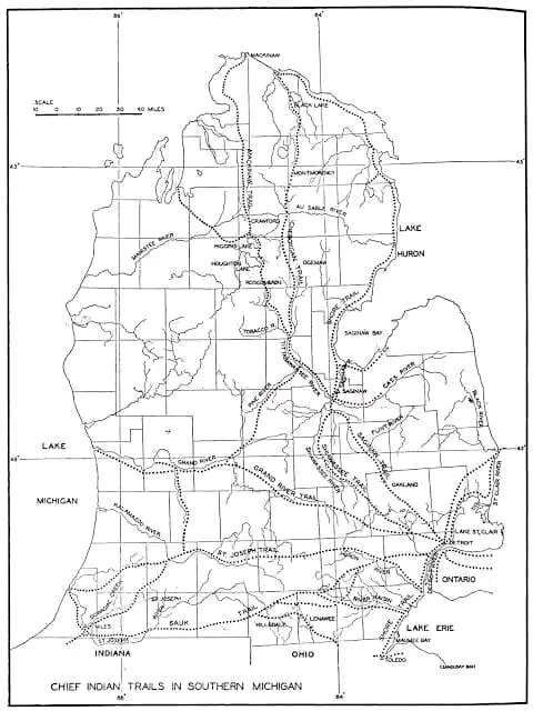
Michigan's first trails were not made by native Americans but ranging buffalo herds in migration. This was especially true on the St. Joseph trail in Southwest Michigan. The major trails in lower Michigan tended to link Indian settlements of Mackinac, Detroit, Saginaw, and Niles. The area around Saginaw had the most native American settlements in the Great Lakes region.
Noted below are native trails that we travel everyday.
Shore Line Trail - A minor trail starting near Toledo and hugging Lake Erie's shore, the Straits of Detroit. Past Fort Gratiot and Lake Huron to a spot near White Rock. White Rock was considered a solemn spiritual place of offering. Today this route is mirrored by Lakeshore Drive from Detroit to Lexington and M-25 north. This trail continues north along the entire shore to Cheboygan. It was considered a minor trail as travel via canoe was preferred along this route. Michigan chose to utilize much of the original Native American trail along Lake Huron and Saginaw Bay to create M-25. Paving of Michigan's First Scenic Highway was started in 1933 and completed in 1940.
Saginaw Trail - One of the oldest trails, this Sauk trail system, went from the Straits of Detroit to Saginaw. Today this starts at the Detroit River and heads northwest up Woodward Avenue to Pontiac, then continues up Dixie Highway through Flint to Saginaw.
Sand Ridge Indian Trail - An ancient trail from Saginaw to Port Austin in Michigan's Thumb. Used primarily for access to the rich hunting ground of the Thumb. Today, M-25 follows much of the same route. However, the old trail is still evident and marked as Sand Road in Huron County. A major canoe passage across Saginaw Bay occurred at Oak Point via Charity Island to reach the AuSable River.
St. Joseph's Trail - A major east-west system called Route du Sieur de la Salle and the Territorial Road. When the Territorial road was first built from Plymouth to St Joseph, a portion of the road was ‘corduroy.’ which means wood lo
25 notes
·
View notes
Text
Updates on Sauk-Suiattle Tribe and the Skagit River: The owner of the three major dams on the Skagit, Seattle City Light, is currently petitioning the US federal government and moving to extend its operation of these dams for the next 30 to 50 years. This re-licensing would allow Seattle City Light to continue operating for decades in the future, just as they have, without protecting salmon, basically. Almost every other dam in the Pacific Northwest has installed “fish passage infrastructure” which allows migrating salmon and other species to continue traveling along the river course. However, Seattle City Light has not installed the fish passage infrastructure on the Skagit. The Sauk-Suiattle Tribe has repeatedly asked for this installation. So the Sauk-Suiattle Tribe launched a lawsuit against the city of Seattle, with the tribe saying that Seattle is deliberately turning public opinion against Indigenous people while also “greenwashing” its reputation by promoting the city and its dams as “green.”
---
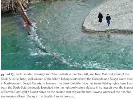
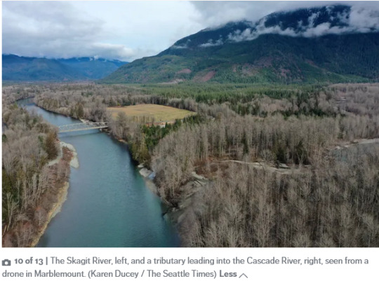


The water sustains life here, in spawning grounds and rearing habitat for native salmon and steelhead. But some 20 miles upstream, the Skagit is quiet. It’s been replaced by the soft crackle and hum of high-tension power lines carrying one-fifth of Seattle’s electricity generated by three century-old dams. Almost 40% of the river is locked up for cheap [...] hydropower. Now, as a fight over the river’s future simmers, a question about the value of life itself is being revisited: Does this river have inherent civil rights?
Seattle City Light is moving to extend its use of the dams for another three to five decades, and tribes and other environmental groups have been pushing the utility to do more for salmon.
The Sauk-Suiattle Tribe, one of the smallest and poorest in the region, and its one-person legal team asked its own courts to recognize the rights of the salmon. A tribal court struck down the request over jurisdictional concerns, but it brought attention to the way governments, utilities, the legal system and landowners perceive their nonhuman neighbors. [...] The 19-acre Sauk-Suiattle reservation is nestled in the foothills of the North Cascades. It’s bound by mature-growth forests [...] and the Sauk and Suiattle rivers. [...]
“This is where nature is,” said Jack Fiander, a member of the Yakama Nation, and longtime legal counsel for the Sauk-Suiattle tribe. “Where we’re at is sort of like the Amazon is to South America. We’ve got to constantly watch and comment on when somebody wants to harvest timber or something, and it’s getting more and more difficult to protect it.”
When the dams went in the Skagit River, there was no consultation with the people who lived there for generations — the ancestors of the modern day Upper Skagit, Swinomish and Sauk-Suiattle tribes and Canadian First Nations, Fiander said.
And the tribes didn’t have the resources then to fight for fish passage.
As the city’s latest re-licensing process ramped up, the Upper Skagit tribe asked for fish passage at the Gorge Dam, the lowest of the three. The Sauk-Suiattle Tribe challenged the electric utility’s “green” power claims, and asked for salmon to have an equal shot at life in the Skagit and its tributaries.
---
Headline, photos, captions, and text published by: Isabella Breda. “’Rights of nature’ movement gains steam in Pacific Northwest. Can it help species on the brink?” Seattle Times. 11 February 2023. [Bold emphasis and some paragraph breaks added by me.]
---

The Washington State Court of Appeals gave the green light for the Sauk-Suiattle Indian Tribe to proceed in its “greenwashing” litigation against the City of Seattle. In September 2021, the Tribe, based in Darrington, filed a lawsuit against the city, alleging City Light’s claims that it’s the “Nation’s Greenest Utility,” and that its hydro-electric operations on the Skagit River have improved conditions for salmon are misleading and harmful to the tribe. The Tribe said the city couldn’t claim its dams are green because they lack fish passage, like nearly every other dam in the Pacific Northwest. [...]
In the original complaint, the Tribe alleged when Seattle took credit for improving conditions for salmon species on the Skagit, it “wrongfully shifted blame” for dwindling fish populations from the city’s dam operations to the tribes. The “public misperception,” wrote the Tribe, makes them a target of “public ire, harassment, and vandalism.” “Seattle has done the worst for salmon while claiming to be the best, meanwhile pointing the finger at everyone else for Skagit salmon decline,” said Jack Fiander, attorney for the Sauk-Suiattle. “Seattle says their greenwashing is harmless puffery, but when you’re turning neighbor against neighbor to improve your corporate bottom line, it is harmful to our community as well as the fisheries resource.”
The legal proceedings come as Seattle City Light is in the process of relicensing its Skagit River dams with the federal government. A new license would last between 30 and 50 years. Negotiations have been underway for four years, with fish passage being the most hotly debated issue. [...]
Last year, the city of Seattle was successful in getting the Sauk-Suiattle’s lawsuit dismissed by a King County Superior Court Judge. [...] Monday’s ruling reverses the dismissal and allows the Sauk-Suiattle Tribe to proceed. The suit seeks to keep Seattle from advertising themselves as being fish-friendly until fish passage is installed over all three dams.
Seattle City Light was the first public utility in the country to earn a green power certification from the Low Impact Hydropower Institute. The Sauk-Suiattle Tribe said the utility used misinformation to gain the green status.
Skagit River Chinook salmon, steelhead and Bull Trout are all listed on the Endangered Species List and are threatened with extinction. [...]
---
Headline and text published by: Susannah Frame. “Court of Appeals sides with Sauk-Suiattle Tribe in ‘greenwashing’ case against Seattle City Light.” King 5 News. 6 March 2023. [Bold emphasis and some paragraph breaks added by me.]
---
Italicized first paragraph in this post added by me.
94 notes
·
View notes
Text
On October 3rd we venerate Ancestor & Saint Ma-ka-tai-me-she-kia-kiakaka aka Black Sparrow Hawk on the 185th anniversary of his passing 🕊 [for our Hoodoos of First Nations descent]
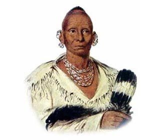
Black Sparrow Hawk was a great Warrior military tactician, & Medicine Man of Sauk Nation, who is best known for the war that bears his name, as the last Indian-Euro war fought east of the Mississippi. It was his defeat signaled the end untimely of 200 years of armed resistance against European colonization on Turtle Island.
Black Sparrow Hawk (Ma-ka-tai-me-she-kia-kiak) was born into the Thunder Clan of Sauk Nation around 1767 & was a member of the Warrior Class. He was the son of a highly respected Medicine Man and would go on to inherit his father's Medicine Bags after he was killed in battle. Though polygamous, had only 1 wife. They had 5 children. They later lost their eldest son & youngest daughter within the same year. Black Hawk mourned the deaths of his children for 2 years - in Sauk tradition.
At age 15 he wounded his first enemy in battle, which initiated him into the Warrior Class & earned him the right to paint his face and wear feathers. From then on he continued to bravery & tactitcal skills on the battlefield. During the War of 1812, Black Hawk's warriors fought alongside the Shawnee on the side of the British Army against the U.S. colonies. Despite the misnomer given by the Europeans, Black Hawk was NOT a chief, he was highly respected & influential leader of a political faction within the Sauk nation that believed in preserving the traditional ways of life before European invasion.
In 1804, five Sauk and Meskwaki chiefs were tricked into signing a treaty with the U.S gov, selling nearly 51 million acres of tribal lands in Illinois, Missouri, and Wisconsin in exchange for various goods & a $1,000 yearly annuity to be paid to the nations. Despite this blatantly illegal act, the U.S. Senate ratified the treaty. The treaty stipulated that the Indians could remain on the ceded lands as long as that land was not wanted for white settlement. As more colonizers invaded Saukenuk territories, tensions rose. To avoid anymore bloodshed, the Sauk and Meskwaki moved to the west side of the Mississippi. However, Black Hawk and his followers refused to give up their lands & remained in Saukenuk. When tensions peaked, the Governor of Illinois dispatched military troops to force out the remaining Sauk and Meskwaki. Black Hawk led his followers across the river out of Illinois & into Iowa during the night.
This spurred Black Hawk to wage the war so named after him, against the U.S. to reclaim their ancestral lands. He led about 1500 followers across to the eastern bank of the Mississippi. This threw the entire frontier into a panic. The Black Hawk War went in for 15 weeks, ending the Battle of Bad Axe in Wisconsin. At its end, starvation, deprivation, & exhaustion killed off 2/3 of his followers. Though he along with 5 of his closest companions, including his eldest son, escaped before the Battle, they was captured 6 weeks later & imprisoned. They were released into the custody a Sauk leader named, Keokuck - Black Hawk's arch political rival - & was directed to follow his counsel and advice. From then on, Black Hawk was no longer recognized as the political leader of the Sauk. In the end, Black Hawk lost more 1,000 folders to the War & more Sauk- Meskwaki territories were taken as war reparations.
Black Hawk would go on to dictate his autobiography to an interpreter. "The Life of Black Hawk" was published in 1833. Despite his dishonor & shame among the Sauk, Black Hawk had ironically achieved fame and great admiration among his former enemies.
After his death, Black Hawk was buried sitting upright inside a small mausoleum of logs. Soon after, his grave was desecrated by grave robbers. His remains were eventually deposited in a museum in Burlington, Iowa which burned down in 1855.
As one of the most feared, yet respected First Nations leaders in history, at the core of his legacy - despite defeat- was his hard-fought battle to preserve the ancestral homelands of his people & preserve their traditional ways of life in the growing shadow of European colonization.
“I am a Sauk…I am a Warrior.” - Black Hawk's final proclamation.
Offering suggestions: play traditional Sauk music, deer or buffalo meat with cornbread/squash/beans/berries/honey, tobacco smoke
‼️Note: offering suggestions are just that & strictly for veneration purposes only. Never attempt to conjure up any spirit or entity without proper divination/Mediumship counsel.‼️
#hoodoo#hoodoos#atr#atrs#the hoodoo calendar#rootwork#rootworkers#ancestor veneration#Black Sparrow Hawk#Black Hawk#Sauk#Sauk nation#First Nations
40 notes
·
View notes
Text

Old Sauk River Trail; Darrington, Washington
#nature photography#green#earthy#trails#paths#hiking#outdoorsy#trees#moss#plants#beautiful#beauty#escape#pretty#spiritual#nature#healing#peaceful#calm#forest#lush#woods#photography#cottagecore#witch#nature aesthetic#explore#wanderer#washington#beautiful places
76 notes
·
View notes
Text
Be Damned
The maps have to change because we can't seem to leave things alone. We must must meddle. We don't actually but it's magnetism. We struggle to leave our hands to ourselves.
On December 14, 2005, 1.3 billion gallons of water rushed out of 650 foot gash in Taum Sauk Reservoir and down Proffit Mountain. The rush lasted a mere 25 minutes, but overwhelmed the Black River with monstrous boulders, full felled trees, and all soil down to bedrock. The Super's house was pushed from its foundation a quarter mile, and babies held onto their Mother, shaken awake. This particular map of Reynolds County was changed when the green disappeared like ghost fingers because of Power and Proffit. We will re-build, they said, and they rebuilt bigger and better, law suits and dollars be damned.
Debris scoured the land down to it's elements, and we humans walk that Scour Trail to witness the billions of years it took to arrive to this day, from rock to soil to tree to reaching skyward. Scarred.
(5.18.24)
#poetry#poets on tumblr#publishing#writers and poets#writing#creative writing#original poem#poem#writeblr#writers on tumblr
2 notes
·
View notes
Text
Father Black Hawk in Voodoo.
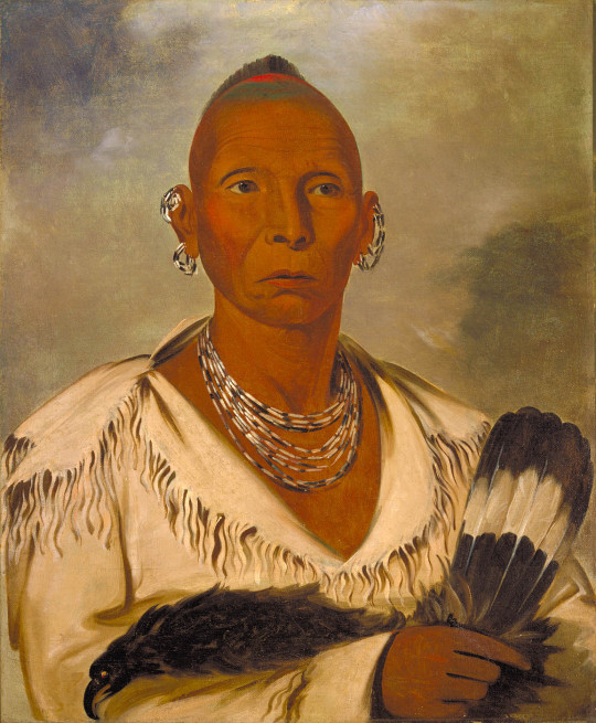
Who Was He: Indian name is Ma-ka-tai-me-she-kia-kiak, or Black Sparrow Hawk, and he was born in 1767 at Saukenuk, located along the Rock River. Black Hawk was born into the Thunder clan. He chose to have only one wife, As-she-we-qua, or Singing Bird, they had five children—two girls and three boys.
Black Hawk was a leader and warrior of the Sauk American Indian Nation. Then he was an appointed war chief. During the War of 1812, Black Hawk fought on the side of the British. Later he led a band of Sauk and Fox warriors against settlers in Illinois and present-day Wisconsin in the 1832. After the war, he was captured and taken to the eastern United States, he died in 1838 in what is now southeastern Iowa.
A Spiritualist Saint: According to some Spiritualists, Black Hawk is a Saint sent by God. It is said that when Black Hawk comes to help, God is right behind him. Anyone who is recognized as doing the work of the Creator is considered a saint, whether or not they have been officially canonized by the Catholic Church.
Mother Leafy Anderson (circa 1887–1927), medium and miracle healer, from the black spiritual churches is considered by some as one of the founders of the Spiritual Churches here in New Orleans. Black Hawk was a spirit that she used and probably was apart of her spiritual court. He first appeared to her in a vision in Chicago, where she lived before moving to New Orleans. She described him as “The Saint For The South,” while White Hawk, served the north.
After being brought to the spiritual churches in the south like where I'm at New Orleans we honor the Native American spirit of Black Hawk. Black Hawk is also considered a Voodoo saint, He is liked by many hoodoo practitioners as well. Because of exploitation by fake marketeers, the image of this Indian spirit guide has had a big influence in my opinion fake commercial hoodoo products.
The Indian is a significant part in the art and organization of the Mardi Gras Indians, as well.
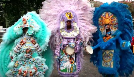
Father Black Hawk, is what he was called because no one could pronounce his given name, so it was change to Father Black Hawk by fake Root Workers. (In my opinion if you don't know who Black Hawk is and understand why he is important in southern history then don't contact him)
Is He Apart Of Hoodoo Or Voodoo: No. Black Hawk is a spirit similar to St. Expedite meaning he is a conjured spirit and like Saint expedite he's called upon us to do certain things. But he is respected in the south and apart of our history.
What Is He Invoked For:
He is invoked for help with money and protection, justice, release from prison, to win court cases, and to overcome tragedy. He is the consummate warrior, and wants to fight your battles for you. They say he will come to those who have enough patience to sit still.
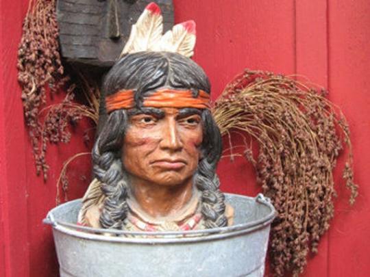

Setting Up His Altar: You need a statue or picture of him with his candle incense. But Do Not get a statue and place it in a bucket or a ceremonial bowl of sand or dirt a statue of an Indian warrior, along with a hatchet, tomahawk, and a spear. (Example above☝️) this is not hoodoo this is fake new age practice.
Give him his own space don't cram him in with others stuff on your altar.
Incense: It is usually a good idea to burn sage, cedar, or sweet grass or even Indian spirit incenses while petitioning Black Hawk.
Color: Red or White
Dislikes: Some people insist on giving him whiskey to “fire him up,” But this is a stereotype of a Indian man drunken on fire water. Disrespect.
Don't put lightning-struck wood on his altar is good (remember, he is of the Thunder clan)
Petitioning Him: put on some traditional Native American music or play a drum, rattle or flute. (I prefer a rattle while listening to native music)(see my post in rattles)
Offering: Offer him tobacco and food like beans, rice. Then recite one of the prayers to Black Hawk, afterwards talk to him and tell him what you need.
Days Of The Week: Wednesday, Sunday
Prayer:. Isaiah 62:6-9 KJV. Is good.
Prayer to Black Hawk: Oh Great Spirit, hear my voice, I believe in your power and your ability to defend me. In the name of all that is good, I ask for your help with this battle, my battle, with those who intend to harm me. Oh Powerful Spirit, you are the Great Chief, Help me with your Warrior medicine and guide me to safety with your Divine protection, shield me from the attacks of my enemies, with your bow and arrow, protect me from the evil thoughts and actions hurled towards me. With your hatchet, cut the chains and ropes that bind me. With your feathers, brush away the negative energy surrounding me. With your eyes, see that no jealousy and envy penetrates me. With your peace pipe, create harmony where there is discord. See that no evil befalls me. Fight the battle to destroy those who will harm me. Take revenge on my behalf and destroy the insurrection of the wicked. This prayer I ask not just for myself but for all of my relations past and present, and for those yet to come, Amen.
#Voodoo spirit#Blackhawk#New Orleans voodoo#Hoodoo spirit#Traditional hoodoo#Conjuring#Native American Spirit#like and/or reblog!#Southern magic#Prayer#Saint#Hoodoo Saint#Voodoo Saint#follow my blog#root work#rootwork questions
11 notes
·
View notes
Text
Panorama from Silver Tip Peak.
flickr
#silver tip peak#silver lake#monte cristo ghost town#poodle dog pass#mountain loop highway#barlow pass#south fork sauk river
0 notes
Text
Climate of Missouri

See Weather Forecast for Missouri today: https://weatherusa.app/missouri
See more: https://weatherusa.app/zip-code/weather-63369
https://edition.cnn.com/2024/05/05/weather/texas-rivers-flooding-rain-forecast/index.html
Missouri's geography varies widely across the state. North of the Missouri River, the land is gently rolling with fertile plains and well-watered prairie country, reflecting its glacial history. South of the river lies the Ozark Mountains, dominating a large portion of the state's landscape. With the exception of the extreme southeastern corner, including the Bootheel, and areas along the western boundary, this region is characterized by rough and hilly terrain, deep valleys, swift streams, and abundant caves and natural springs. Elevations range from 1,000 to 1,400 feet (300 to 425 meters) above sea level, although near the western border, elevations rarely exceed 800 feet (250 meters). Taum Sauk Mountain, located about 90 miles (145 km) south of St. Louis, stands as the state's highest point, reaching 1,772 feet (540 meters) above sea level. In far southeastern Missouri, a part of the alluvial plain of the Mississippi River features elevations below 500 feet (150 meters). Near the southwestern edge of this region lies the state's lowest point, where the St. Francis River flows into Arkansas at an elevation of approximately 230 feet (70 meters).
See more: https://weatherusa.app/zip-code/weather-63041
https://weatherusa.app/zip-code/weather-63043
https://weatherusa.app/zip-code/weather-63071
https://weatherusa.app/zip-code/weather-63077
The St. Francois Mountains in the eastern Ozarks are characterized by igneous granite and rhyolite outcroppings, adding a unique geological feature to Missouri's landscape. In contrast, the remainder of the state is primarily underlain by sedimentary rocks, including limestones, dolomites, sandstone, and shale.
Missouri is generally considered tectonically stable, with only occasional small earth tremors occurring, particularly in the southeastern portion of the state. However, there remains a possibility of another devastating earthquake similar to those centered at New Madrid in 1811–12. While the likelihood of such an event is uncertain, the potential impact underscores the importance of ongoing monitoring and preparedness efforts in the region.
Missouri's diverse geography and soil conditions facilitate farming across all its counties, although the Ozark Mountain region primarily supports livestock and poultry farming due to its thin soil. The northern part of the state benefits from rich glacial and loessial soils, contributing to its agricultural productivity. Additionally, the extensive alluvial soils in the bottomlands along rivers and streams further enhance farming potential in Missouri. The Missouri River, which drains most of the state, plays a significant role in its drainage system.
Artificial lakes, created by damming rivers and streams, are a notable feature of Missouri's landscape. The Lake of the Ozarks, formed by the Bagnell Dam on the Osage River, stands out as one of the largest man-made lakes in the country, offering both hydroelectric power generation and recreational opportunities.
Missouri's climate is influenced by a combination of cold Canadian air, warm Gulf of Mexico air, and drier southwest air. Summer winds typically blow from the south and southwest, while winter winds originate from the north and northwest. Precipitation, crucial for crops, varies across the state, ranging from around 35 inches (890 mm) in the north to nearly 50 inches (1,270 mm) in the extreme southeast. Missouri experiences about 25 tornadoes annually on average, owing to its location on the edge of Tornado Alley.
See more: https://weatherusa.app/zip-code/weather-63117
https://weatherusa.app/zip-code/weather-63344
https://weatherusa.app/zip-code/weather-63369
In terms of plant and animal life, Missouri boasts a diverse range of flora and fauna. While forests cover about one-third of the state, much of the original prairie land has been converted for cultivation. Nonetheless, efforts by governmental and nongovernmental organizations have preserved scattered prairie remnants. Missouri's state parks harbor numerous plant and animal species, including over 100 species of fish, 200 species of birds, and various mammals. Historically, large animals like elk, deer, bison, and bears were abundant, but their populations declined due to European settlement and agricultural expansion. However, conservation efforts, such as restocking programs, have led to the recovery of certain species, including deer, which now number close to a million in the state. Additionally, Missouri is home to a small population of bears that migrated from Arkansas, although hunting them is prohibited.
See more: https://weatherusa.app/zip-code/weather-63770
https://weatherusa.app/zip-code/weather-63739
0 notes
Text
Friday, June 2, 2023 Day 02
End Mileage 28889 5:00 PM CDT
Start Mileage 28608 6:40 AM CDT
Miles 281
Gas 14.15
Gas 33.45
Breakfast 9.60
Postcards 1.00
Motel 109.20
Total 167.60
Left motel and headed west to Wickliffe Mounds State Historic Site. But I found the gates locked. Then I drove on and crossed the Ohio River on a narrow bridge. Immediately was at an Illinois State Park – Fort Defiance. Lewis and Clark were here at the confluence of the Ohio and Mississippi River. It was a large body of water before me. I took some selfies. Travelled north through Cairo, IL. A ghost town except for a very few souls. Continued driving to Horseshoe Lake, a swampy lake with Cypress trees. I posed for a few selfies and then circled the lake to a road peninsular. Walked the area for some selfies. The back on the main road crossed over the Mississippi River at Cape Girardeau, Missouri. Was planning to see the city’s rose garden, but the garden had been dug up. Just dirt. So I continued to drive to Missouri’s high point. It was hot for the day, but cooler at Taum Sauk Mountain. Climbed the tower, but not many, nor much of a view. Took some selfies on the tower. The last stop for the day was at Fort Davidson for the Civil War battle of Pilot Knob. Interesting site. The North basically retreated, but the South lost. Then on to suburbs of St. Louis to get on I-70 west. Found a motel – Days Inn. Not the best. Ate supper in the room. Feeling better today. A nice traveling day.
0 notes
Text
Missouri State facts
mother of the west
father jacques marquette and louis jolliel land in 1673
largest beer producing plant anheuser bush
first newspaper in 1808 by joseph charles
cholers epifemic kill 4000 in 1849
lighting strike state capital
missouri river longest in usa
cave state
state capital jefferson city
largest city kansas city
state size 69,704 sq miles
population 6,177,957
statehood 8-10-1821
highest point taum sauk mountain 1772ft
lowest point st francis river 230ft at arkansas border
state motto let the welfare of the people be
state nickname the sepreme law, billion state, care state, gateway state lead state, ozark state, show me state
nobel prize winner 4
famous people 6
state animal missouri mule
state amphibian bullfrog
state bird bluebird
state game bird bobwhite quail
state inverteebate crayfish
mineral calena
state reptile three toed box turtle
state horse missouri fox trotting horse
state dinosaur hypsibema missouriensis
state flower hawthorn
state insect honey bee
state fossil criroid
state tree flowering dogwood
0 notes
Text
Keosauqua!
Where is Keosauqua? It is a town in southeast Iowa, not far from the border with Missouri. “The word Keosauqua derives from the Meskwaki and Sauk name for the Des Moines River, Ke-o-saw-qua, which literally translates as Bend in the River.”
0 notes
Text
History and Recreation on the Mountain Loop Highway:
Assignment one rewrite
Snohomish County, February 6, 2023 – Located in the foothills of the North Cascades the Mountain Loop Scenic byway is a 52-mile Washington state highway in Snohomish County.
It’s a popular weekend getaway for people from across the state. Spread out next to the Sauk or Stillaguamish Rivers and breath in fresh fragrances of pine sap and maple tree bark.
Checking in with visitor information receptionist Erika Morris at the Darrington information center, the Mountain Loop Highway is a great highway/byway to begin venturing outdoors. Its history rests in lumber harvesting, old mining camps and railroads.
“The Mountain Loop Highway is just that; a Highway” she said. Most outdoor hiking, biking, camping trails are owned and maintained by the National Forestry Service. We maintain the nature area and public trails for recreation, hiking and camping. The actual name comes from the state-owned highway.
The Mountain Loop starts in Granite Falls, connects to Arlington and Darrington and wraps around back to Granite Falls. Stationed at the Verlot ranger station just outside Granite Falls is ranger Jonathan Sutherland. He looks after trails and campgrounds from Verlot to about Bedal Campground halfway between Granite Falls and Darrington.
He talked about his prior work in the peace core. “After Covid started it was hard for Peace Corps to do work. So, I came home to Snohomish and was out of work”. He applied to the National forestry service and became a park ranger in the south most part of the Mountain Loop Highway. Part of the mount Baker-Snoqualmie National Forest. “It’s work with peace of mind”.
When gold was discovered in the Cascade mountains, it came with the lofty dream of mineral wealth. The elusive rich vein of gold was never discovered. A silver deposit was found just below Boston Glacier near the headquarters of Thunder Creek in 1892. But the cost of getting the ore out was too expensive. By 1913 most mining companies had folded. “Mining didn’t resume until WWII increased the demand for metal and then again during the 1940s and 50s for the last time. Short working seasons, unpredictable weather conditions, difficult transportation and lack of working capital hampered large scale development” (National Park Service, 2020). The mining didn’t last long but the rails were in place to carry out the real treasure of the PNW – timber. Roads were built to replace rails and trucks replace the trains.
Granite Falls is known as the gateway to the Mountain Loop. Growth is strong as more people flock to rural areas in search of homes. A big part of Snohomish County history is founded in the search for natural resources and timber harvesting. Many trails along the Mountain Loop are linked to the development of nearby towns like Arlington and Darrington. A day off the Mountain Loop provides insight to the development of the area. It has a host of outdoor activities in environment education and a beautiful landscape.
References
Purdue Online Writing Lab. (n.d.). General Writing FAQs. Purdue Online Writing Lab.https://owl.purdue.edu/owl/general_writing/general_writing_faqs.html
National Park Service. (2020, January 10). Miners. https://www.nps.gov/noca/learn/historyculture/miners.htm
0 notes