#Pine Island Glacier
Explore tagged Tumblr posts
Visit Tumblr Blog
Explore Tumblr blogs with no restrictions, modern design and the best experience.
Last Seen Tumblr Blogs


Fun Fact
US Tumblr user growth rate is estimated to slow down to 4.1%.
Text
youtube
Glacier Calving: The Powerful Force Behind Massive Waves and Climate Change Insights
Glaciers, those monumental rivers of ice flowing from high mountain peaks and polar regions, are not only stunningly beautiful but also hold incredible, often unpredictable power. Among the most captivating and intense events involving glaciers is glacier calving—a natural process where enormous ice chunks break away from a glacier’s edge and crash into surrounding water. This dramatic phenomenon not only creates an unforgettable visual display but also generates massive waves. In this article, we’ll explore glacier calving, what causes it, the powerful waves it creates, and the broader implications for ecosystems, human activity, and climate science.
What is Glacier Calving?
Definition: What is Glacier Calving?
Glacier calving is the process where large pieces of ice detach from a glacier's edge and fall into the adjacent water. These ice chunks vary in size, from small pieces to massive blocks as large as multi-story buildings. Calving is a powerful and visually spectacular event that can produce waves felt miles away.
Where Does Glacier Calving Occur?
Calving occurs most frequently at the terminus (the end) of glaciers that extend into bodies of water like lakes, oceans, or fjords. It’s most common in polar regions, such as Greenland and Antarctica, where glaciers meet the sea. These environments allow ice chunks to break off and fall into the water, forming waves that can be incredibly powerful and far-reaching.
How Does Glacier Calving Happen?
Calving happens due to the natural movement of glaciers. As a glacier moves forward, driven by gravity, the ice at its edge becomes thinner and fractures. Over time, these fractures deepen, eventually causing large chunks of ice to break away. The forward motion pushes these ice chunks towards bodies of water, where they drop, creating an impactful and sudden splash.
The Science Behind Glacier Calving and Wave Formation
Ice Dynamics and Fracture Mechanics
The constant advance of glaciers creates stress along their edges, leading to cracks and fractures in the ice. When the ice reaches a critical fracture point, large sections break off. This detachment causes sudden displacement as the ice hits the water, creating waves that can be extremely powerful.
How Does Glacier Calving Generate Waves?
When an ice chunk detaches and crashes into the water, it displaces the water around it, creating a splash and powerful shockwaves. The size and intensity of the resulting wave depend on the size of the ice chunk. Larger ice pieces create more significant waves, capable of traveling far distances.
Wave Propagation in Glacier Fjords and Bays
Once a calving event occurs, the waves created by the impact move outward from the point of collision. In confined areas, like fjords or bays, these waves can be particularly intense. They bounce off rock walls, sometimes becoming even larger and more forceful, and can travel for kilometers, posing a danger to anything in their path.
The Impact of Calving Waves on Ecosystems and Human Activity
Environmental Impact: How Calving Waves Affect Marine Ecosystems
Calving waves can have a significant effect on local ecosystems. The waves stir up the seabed, displacing marine organisms and disturbing habitats. Over time, repeated calving events can also erode coastal areas, affecting both flora and fauna in the surrounding environment.
Human Implications: Why Calving Waves Are Dangerous
For people living in or near glacier regions, calving waves can pose severe risks. Fishing vessels, research ships, and tourist boats are especially vulnerable, as calving waves have capsized boats and caused substantial damage in the past. Coastal communities near glaciers or fjords may also feel the impact of these waves, making it important for ships and local authorities to remain vigilant.
Climate Change and Glacier Calving: A Connection with Global Implications
Climate change is accelerating glacier calving worldwide. Rising temperatures cause glaciers to melt and thin, making them more prone to calving events. This not only increases the frequency of calving but also contributes to global sea level rise as more ice melts and enters the ocean. Areas like Greenland and Antarctica, where calving is occurring at unprecedented rates, are contributing significantly to rising seas—a growing concern for coastal cities and communities worldwide.
Notable Glacier Calving Events and Their Massive Waves
To understand the sheer power of glacier calving, let’s look at some notable glaciers known for their spectacular calving events.
Jakobshavn Glacier, Greenland: One of the fastest-moving glaciers globally, Jakobshavn has witnessed some of the largest calving events on record. Chunks of ice as large as skyscrapers break off, creating waves that can be felt miles away.
Hubbard Glacier, Alaska: This Alaskan glacier is known for periodic large calving events that generate waves affecting cruise ships and other vessels in nearby fjords. This glacier’s movements attract scientists and tourists alike, both drawn by its power and potential risks.
Pine Island Glacier, Antarctica: As a significant contributor to ice loss in Antarctica, Pine Island Glacier’s calving events are substantial enough to be detected by seismometers thousands of miles away, showcasing the global scale of calving’s impact.
Fascination and Caution: Observing Glacier Calving Events
The Appeal of Glacier Tourism
For many tourists, witnessing a glacier calving event is a once-in-a-lifetime experience. The intense sound—often compared to a thunderous "crack" or "roar"—followed by a massive splash and radiating waves, creates a powerful, memorable scene. Locations such as Alaska, Greenland, and certain parts of Antarctica are popular destinations for this reason.
Safety Precautions for Viewing Glacier Calving Events
Despite their allure, calving events are highly unpredictable, and the waves they generate can be dangerous. Tourism operators and guides near glaciers must take strict precautions, maintaining safe distances from glaciers to ensure the safety of visitors. Special care is necessary for boats, as the waves can capsize small vessels that venture too close.
The Future of Glacier Calving and Its Impact on Sea Level Rise
As climate change continues to increase global temperatures, glaciers worldwide are expected to retreat and calve more frequently. This trend not only raises the likelihood of dangerous waves but also leads to long-term impacts, such as accelerated sea-level rise. Glacier calving events remind us of the urgent need to address climate change and mitigate its effects on our planet’s natural systems.
Conclusion: Glacier Calving as a Reminder of Nature’s Power
In summary, glacier calving is a breathtaking natural event and a powerful force with significant environmental, social, and scientific implications. From the thunderous crash of falling ice to the waves that ripple across fjords and bays, glacier calving captivates us while serving as a stark reminder of the interconnectedness of Earth’s natural systems. As climate change continues to reshape our world, glacier calving highlights the need to understand and preserve these fragile ice giants that are vital to our planet’s health and future.
By understanding glacier calving, its causes, and its consequences, we not only gain insight into one of nature’s most spectacular displays but also increase our awareness of the urgent climate issues facing our planet today.
Go To The Power of Glacier Calving
#glacier calving#calving waves#glacier waves#environmental impact of glaciers#climate change glaciers#sea level rise#melting glaciers#Arctic glaciers#Antarctic icebergs#Greenland glaciers#glacier tourism#glacier ecosystems#glacial ice fracturing#marine ecosystems climate change#global warming impacts#glaciers and climate change#coastal erosion by glaciers#Pine Island Glacier#Jakobshavn Glacier#Hubbard Glacier Alaska#glacier safety measures#glacier calving events#polar science#fjord waves from glaciers#climate change impacts on ice#Youtube
0 notes
Text
Some things I’ve been thinking about. At times being an American trad witch is incredibly frustrating and at others it’s absolutely exhilarating, rewarding. Reconnecting with my ancestral ( primarily french and scottish ) lore, magical practices, witchcraft etc has and will continue to inform my practice but I’ll never be a “french” witch. I’ll never be a “scottish” witch. I can find a lone hawthorn or a sacred tree guarding a hidden spring to tie the cloutie to, I can divine via a snail’s mucus trail, Fly to the Sabbath to meet The Abbess, heed the Dame Blanches, pluck the golden bloom with songs to St Columba, safeguard me and mine via silver, spring water and juniper. Yet there’s many things I’ll never know or be able to do. Whether that’s because these things are so tied to the land or a specific place, language barriers, ( working to overcome this one ) or due to the ( well warranted) gate keeping of lore and practices.
This used to be a source of great confusion for me. I think because I was afraid( due to my previous new age fuckwittery ) to experiment, do anything other than what I understood as “traditional”. My understanding being too rigid at the time; the pendulum swung from one end of the spectrum to the other. This delayed my progress and “froze” me. I was left wondering what an “American” trad craft would look like; most our books do come from a European POV. Learning of our own magical traditions as well as those of my Canadian family ( still working on that one haha ) helped. Reading Robin Kimmere helped. Reading Schulke, him being an American and writing on American plants, helped too. I’ve come to know Sugar Maple and Plantain as powerful spirits. Both teaching important lessons on how to rectify my ancestors mistakes, to foster relations with the First Peoples and how to incorporate the magic of this land into my craft. Rather than being frustrated by my being American I see it as a challenge now. I get to explore spirits, plants, places, animals, spiritual/physical ecologies ( is even really a difference between these?) completely unknown to my ancestors. I get to reconcile the old and the new. To learn from Spirit Direct. Tradition isn’t the worship of ashes, it’s the preservation of Fire. New wood must be added to keep The Fire burning. The Devil of this land certainly is a spirit of the unknown.

I am the land, the land is me.
I don’t own it, to it I owe all.
To it my body will return, the tithe paid.
I’m not rolling hills of heather, white chalk cliffs, the monk’s island nor the azure coast. The memories of these places echo distantly in my blood, sung alive by my ancestors shades. Part of me they’ll always be; yet it’s not who I am. Not what I am.
I’m craggy shores, dull-jade waves bearing down upon the tired rocks. I am musky pine forests veiled in mist. Sun-venerating oaks hugging the shoreline. Bleeding alders in damp ground swelling. Proud maples sustaining generation upon generation with their boiled blood. Death-grey clay, exposed by running spring.
I am the kudzu, the itching moth, the knotweed, the Norway maple, the ivy wrecking havoc upon the land. My surname and light skin proof of a genocide ongoing. I am my ancestors sins; the specter of the Old Growth forests, their grief hanging over the land like a fog. Every interaction with The Land tinged with sadness, loss.
I am my maternal side’s copper curls. Melusine’s pride. Ave Landry! Ave Gauthier! Forebears mine.
I am my paternal side’s grief. The end result of decades of cultural warfare. The Jesuits stole our name….my hair will not be cut.
Never will I libate these glacier carved valleys with booze.
I am the plantain, learning a kinder way. The sumac reclaiming the orchard.
My Februarys, my Marches aren’t snow drops and daffodils peaking through the frozen ground. They’re steely skies and walls of sleet. Bloodroot heralds winters wane; not Brigid’s flower.
My June isn’t fields of poppies, it’s seas of crimson staghorn blooms skyward reaching.
My augusts aren’t golden shafts of wheat, swaying in summer’s last breaths; they’re explosions of neon-violet and honey-yellow. Corn ripening on the vine, supporting the climbing bean. The cicadas song reverberating.
Old Michaelmas marks harvest’s end, October potatoes long buried in soils darkness finally exhumed. The Devil his Rosy Briar to ascend and plunge.
With Novembers first snows the Dead come in.
I’ll never process around a standing stone nor know what it is to live and eat off the land my dead lay in. Finally, I’m learning to be at peace with this. To love and know the land I live on. I’ll always be a stranger here, a guest. I hope to be a good one.
#folk magic#tradcraft#traditional witchcraft#witch#folklore#magic#magick#traditional craft#witchcraft#occult#animism#animist#animistic#animists#witches#indigenous#reparations#Michaelmas#native plants#invasive plants#ancesters#ancestry#ancestral veneration#American witch#American witchcraft#Daniel schulke#traditional American witchcraft#American traditional witchcraft#Corrine Boyer#poetry
107 notes
·
View notes
Text
SSO: LIFE WARDENS The magic trees of Jorvik

Main tree: Jordrassil in the Jorcrater -> The Crater is where the first pandorian contact happened, Aideen met the centaurs -> She combined the 3 magics (Light, Earth, Pandorian) and fought Garnok. -> Jordrassil is the first tree, manifestation of Aideen’s life powers. -> Also the place where she dispersed, gave up her light and souls to the creatures of the island -> Master portal- planted many other trees on the island, so she can get around quicky in the war. -> Jordrassil has the strongest hints of Aideen’s light (other than MC) would be a top prize for G to corrupt
Life Wardens: Primeival trees -> Fast travel system, their roots for portals after saying the right incantation. -> From Jordrassil you can fast travel to ANY (living, friendly) tree -> From other trees only to the next in the network -> Guarding and strengthening any magic: Aideen’s or Garnok’s if corrupted. -> They can be awakened and speak, have different personalities.

1. Harvestlands: -> Sleeping Widow: Forgotten Fields. Helped Lisa, 1st one we meet. Wants to reconnect with the other Trees. Protective of the little one also growing in the Forgotten fields. -> Golden Lady: Scarecrow Hill. Grows Golden Apples, which are pure Aideen/Light power. Neighbors and best friends with the Widow. -> Ancient Sentinel: Wildwoods. Protected by the Wild Horse tribes. There is a pandorian rift underwater in the lake, through which Pandorian magic seeps through, infects the area. We close it when Garnok fully corrupts Pandoria and manage to prevent the Sentinel from being corrupted. -> Singing Yew: South Hoof. Helped Justin. Slumbering in the fields, the winds blowing through the branches make a song. -> Silent Poplar: Firgrove Mountain. Very mysterious. Turns out a hundred years ago he was corrupted and almost lost to the darkness, but they used the cleansing ritual to save him. -> Hidden Willow: Fort Maria. Hiding underground in a cave, guarding the library. The first place we go when we unlock the Tree Portal fast travel system. Guards the knowledge about the Life Wardens.

2. Winterdale -> Fire Glory: Ashland. Red pine, likes the warmth there, very lively, constantly talks about how much she likes the warm and finds the fires and the volcano beautiful. -> Glacier Heart: Dino Valley. Sister to the Ashland one, likes the cold. Constantly annoyed by Fire Glory’s neverending chitchat about Ashland, which she can hear. -> Astral Crown: Starshine mountain. Next to the Secret Stone Circle, protects it, she is why the DRs can’t come close to the circle. -> Silver Runebark: Rimefang woods. Silver leafs, revered by the Kallters, likes them, his bark covered in glowing azure runes. -> Wise Leaf : Anvil woods. Helped the druids protect the forest from DC, gives them advice. Talks in verses, metaphors and tales.
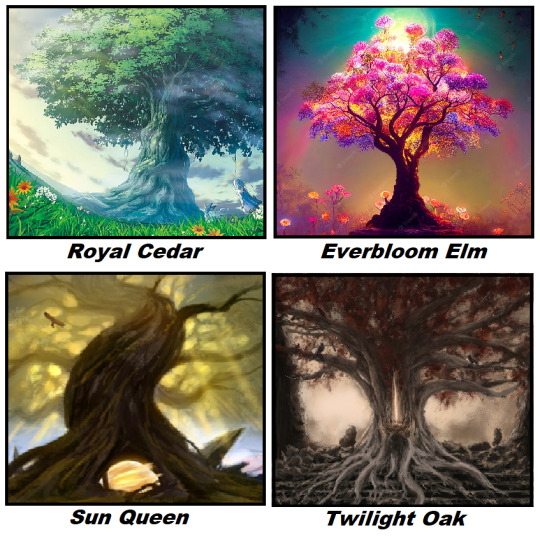
3. Springvalley -> Royal Cedar: Blossom woods. Majestic and reliable, he has been guarding the Blossom woods and Springvalley from the storm in Winterdale. -> Everbloom Elm: Everspring plateau. Covered in various flowers, she’s very proud of them. Gives you some random herbs every day if you go say hi to her. The tree is so full of herself, she’s basically giving you an autograph, don’t worry about it. -> Sun Queen: Suncrown lake. Cleansed from corruption by MC and SRs. Protects the Von Blyssen manor and vineyard. -> Twilight Oak: Morrinweald. The source of the valas’ power. Was corrupted by dark powers, later cleansed by MC and SRs.
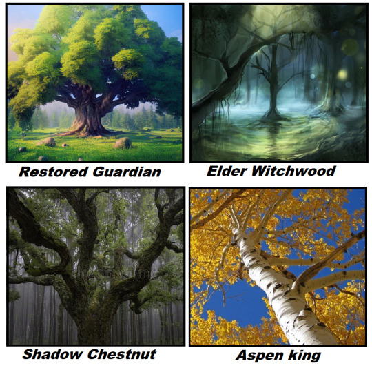
4. Summerplains -> Restored Guardian: The Great Clearing. Was cut down long ago. We grow it back, like the one in Forgotten Fields. -> Elder Witchwood: Old Morass. She liked to watch the rituals the witches did in the swamp. Quickly becomes best friends with Pi and Mrs Holdsworth. -> Shadow Chestnut: Claymore mountains, hidden. He was tasked with keeping an eye on the Claymores- they have been serving evil for a long time. -> Aspen King: Lone Star canyon. Yellow-golden leaves, huge tree. Likes the Lone Star Cowboys, who bring gifts (anything from horseshoes to elk skulls).
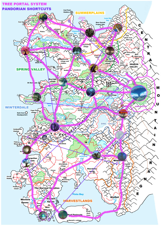
The New Fast Travel System: -> Advantage of using the trees: you pay for the trailer rides, but you use the tree portals for free. -> With all 4 big areas unlocked, you will need to cover great distances. You have a lot of choices: 1, Trailers (costs money, but most accurate, quickest) 2, Tree portals (free, but less accurate, takes a bit of time) 3, Pandoria portal in-between shortcuts (free, jumps great distances, but least accurate). -> Trailer rides now cost more money the farther the distance you go. Prices: 25 JS: if you travel inside a great area (e.g. staying inside Harvestlands). 50 JS: if you travel to another great area next to you (e.g. from Harvestlands to Winterdale) 75 JS: travel to another area second next to you (e.g. from Harvestlands to Springvalley) 100 JS: travel to third next area (e.g. from Harvestlands to Summerplains) -> [Keep it in mind, that by our game design the JS cap has been raised to 100.000 and you earn more money, via reworked quest rewards.]
#sso#starstableonline#star stable#star stable online#ssoblr#sso rewritten#sso full story series#sso map#sso life warden#sso tree#sso magic#sso aideen#sso game design
51 notes
·
View notes
Text
Acadia National Park Confronts a Rising Tide (Sierra Club)
The glaciers are melting in Glacier National Park. The forests around and in Yosemite National Park are burning down. Seasonal bodies of water are forming in Death Valley National Park. All sort of human and weather or climate associated events are doing damage to the Everglades. The Rio Grande sometimes flows through Big Bend. Joshua trees are not propagating and might someday burn down in Joshua Tree National Park. The time is way passed for the National Park Service to redefine "conservation" as "preservation," and do something, as best it can, to protect these public lands and their inhabitants, from human caused harm.

A major storm in January 2024 sent Mount Desert Island's Seawall Road into the Atlantic Ocean, a harbinger of things to come as surrounding Acadia National Park contends with climate change and sea level rise. | Photo by Kyle Paoletta
Over the course of four days in January, a one-two punch of winter storms walloped coastal Maine and destroyed infrastructure across Acadia National Park that rangers are still repairing as they gear up for the millions of tourists who visit every summer. Following nearly identical tracks up the East Coast, each weather system brought hurricane-force winds and a record-setting storm surge of ocean water that flooded, and then flooded again, seaside areas all over Mount Desert Island, which is home to not only the national park but also several towns and a mishmash of state, federal, and private land.
The Gulf of Maine is warming faster than almost any other body of water on Earth, and climatologists estimate the tides around Mount Desert Island are likely to rise by a full foot over the next 25 years. The temporary sea level rise brought on by the January storms offered a peek into what could be a new normal by mid-century, forcing officials at Acadia to confront the reality that restoring the current damage will require a much more rigorous process than merely rebuilding roads and trails, many of which were established over a century ago. It's a situation that illustrates the inherent tension between the two missions of the National Park Service writ large: conservation and tourism.
On the west side of the island, pine trees part to reveal sweeping views of the Atlantic Ocean where a state highway passes over a natural breakwater formation called Seawall. In January, the storms dragged away hunks of asphalt from that roadway and covered a nearby picnic area in rocks and the trunks of 700 or so trees downed by winds gusting in from the ocean. Down the road, one of the Park Service’s interpretative panels had been fully uprooted and tossed aside, as if by a giant. Subsequent storms that rolled over Mount Desert Island during the spring deposited yet more stones in the picnic area, forcing rangers to keep putting up orange cones to dissuade visitors.
When I visited in April, officials at Acadia were still in the early stages of recovery. The facilities crew had its hands full with repairing 1,000 feet of the Ocean Path, a vital trail in Acadia that connects two popular destinations: the island’s only sandy beach and Thunder Hole, where the dramatic crash of waves into a granite chasm draws some of the park’s largest crowds. Fixing the Ocean Path was just one line item in the tens of millions of dollars in damage sustained by Acadia.
6 notes
·
View notes
Text

TALES OF THE NINE REALMS; WORLDBUILDING
Sovereign
adjective sov▪︎er▪︎eign
of the most exalted kind
At the time of the old gods' death Yggdrasil was one land with no borders or kings. But over 400 years Lords and kingdoms arose and nine realms came to be. These Realms clashed and struggled for ultimate power resulting in a war spanning multiple generations that came to be known as The War of Realms. In the aftermath of the war the sovereign rulers of the Realms entered into an alliance creating The Council of The Realms which is ruled over by the High King. This High King also has sovereignty over all of Yggdrasil.

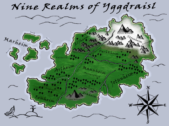
Nine Realms:
Arlheim - located on the western coast. Borders are marked by the Daggry Mountains to the north, the Lycon River to the south, and the Aleborg River to the south. Mostly farmlands and woodlands. Located here is Valhalla, the largest and most powerful city in all the Nine Realms. The High King's court and The Council of The Realms is held here.
Elfheim - located north of Arlheim. Borders marked by Daggry Mountains to the south, the Great Sea to the north and west, and the Lycon River to the east. Very mountainous with deep valleys covered in thick pine forests. The Light Elves dominate the land and there are very few non-elves living there. The court of the Sovereign Queen of Elfheim is located in the city of Gimli.
Darhkhiem - located east of Elfheim. Borders are marked by the mountains to the north and east, the Lycon River to the west, and the Leda River to the south. Mostly grasslands and rolling green hills. Many mining towns are located here. The court of the Sovereign King of Darhkhiem is located in the city of Heliodor.
Stonehiem - located north of Darhkhiem. Borders are marked by the Lycon River to the west, the Great Sea to the north and east, and mountains to the south. Filled with ice-capped mountains, glaciers, and frozen barren tundras. The least populated realm. The court of the Sovereign Queen of Stonehiem is located in the stronghold of Rothguard.
Jotunheim - located on the eastern coast. Borders are marked by the Great Sea to the east, the Trollem River to the west, and the Ironwood to the north. Mostly woodlands and low rolling hills. The court of the Sovereign King is located in the city of Skyguard
Mannheim - located in the center of Yggdrasil. Borders are marked by the Lycon River to the west, the Leda River to the north, the Trollem River to the east, and the dead woods to the south. Very flat plains and farmlands. Many roads run throughout Mannheim that connect the other Realms to one another. The court of the Sovereign King of Mannheim is in the city of Kattenguard.
Esaheim - located south of Mannheim. Borders are marked by the Nidhog Gorge to the west, the dead woods to the north, the Trollem River to the east, and the Great Sea to the south. The realm was once lush forests but due to active volcanoes the land has become barren. The realm was ruled from the city of Sutguard but has since been abandoned.
Fenheim - located on the southern end of Yggdrasil. Borders are marked by the Nidhog Gorge to the east, the Aleborg River to the north, and the Great Sea to the west and south. Mostly forests and swamplands. The court of the Sovereign King of Fenheim is in the city of Andvar. Andvar also holds the largest Library of Archives.
Marheim - located to west in the Great Sea. A collection of five islands: Iona, Antrim, Alban, Argyail, and Notun. The court of the Sovereign King of Marheim is on the island of Notun.
(follow for more)
2 notes
·
View notes
Text
Top 10 Winter Destinations to Visit in 2025

Ready to explore new destinations or book your next dream vacation? Trip offers the best deals on flights, hotels, and travel experiences!
💡 Why Choose Trip? ✔️ Exclusive travel deals and discounts ✔️ Easy and secure booking process ✔️ 24/7 customer support for hassle-free travel ✔️ Global reach with millions of travel options
Sign up now and start planning your next adventure! Click here to join Trip.com and book your trip today!
✨ Don’t miss out on exclusive offers waiting for you!
Winter transforms our favorite landscapes into magical wonderlands, creating a serene and enchanting atmosphere. From snow-covered peaks to frozen seas, this is the season to experience nature’s most captivating beauty. If you’re looking for unforgettable places to visit this winter, here are the top 10 destinations that should be on your list.
1. Lapland, Finland — A True Winter Wonderland

Nestled in Finland’s northernmost region, Lapland is the epitome of a winter wonderland. Picture snow-laden pine trees, frosty mornings, and temperatures that dip as low as -30°C. Warm up in a Finnish sauna, visit Rovaniemi (the official hometown of Santa Claus), or chase the magical northern lights. This fairy-tale destination is perfect for a Christmas getaway.
2. Lofoten Islands, Norway — Winter Meets the Ocean

The Lofoten Islands are a dreamscape of snow-covered peaks rising dramatically over icy blue waters. The small fishing village of Reine, with its iconic red Norwegian houses, provides breathtaking views of rugged mountains. A road trip across the islands reveals treasures like Hamnøy and Ramberg, each turn unveiling jaw-dropping winter scenery.
3. The Swiss Alps — A Winter Paradise

Switzerland’s stunning landscapes reach new heights of beauty in winter. The charming village of Zermatt, set against the iconic Matterhorn, feels like stepping into a Christmas movie. Whether you’re skiing the slopes, riding the Gornergrat Railway for panoramic views, or simply soaking in the magical atmosphere, the Swiss Alps promise an unforgettable winter experience.
4. Bavaria, Germany — Fairy Tales Come Alive

Bavaria, in southern Germany, offers enchanting winter scenes straight out of a storybook. Explore the Neuschwanstein Castle, the inspiration behind Disney’s Sleeping Beauty Castle, or visit Berchtesgaden for its idyllic alpine charm. Don’t miss Konigssee Lake, where you’ll find the picturesque St. Bartholomew’s Church surrounded by snow-kissed mountains.
5. Bryce Canyon National Park, USA — A Unique Winter Experience

Located in southern Utah, Bryce Canyon’s crimson hoodoos (towering rock formations) create a striking contrast against a blanket of snow. Hike to Sunset Point for panoramic views and witness the breathtaking play of light as the sun dips below the horizon. It’s a surreal and serene destination to explore during the colder months.
Ready to explore new destinations or book your next dream vacation? Trip offers the best deals on flights, hotels, and travel experiences!
💡 Why Choose Trip? ✔️ Exclusive travel deals and discounts ✔️ Easy and secure booking process ✔️ 24/7 customer support for hassle-free travel ✔️ Global reach with millions of travel options
Sign up now and start planning your next adventure! Click here to join Trip.com and book your trip today!
✨ Don’t miss out on exclusive offers waiting for you!
6. Alaska, USA — Untouched Wilderness

If you’re seeking untamed beauty, Alaska is the place to go. This vast wilderness is home to towering mountains, immense glaciers, and incredible northern lights displays. Helicopter or bush plane rides offer access to some of the most remote and awe-inspiring locations. Alaska’s sheer scale and pristine landscapes make it a winter haven for adventure lovers.
7. The Canadian Rockies — A Snowy Dreamland

Canada’s Rocky Mountains are a winter wonderland like no other. Banff, with its charming town and towering Cascade Mountain backdrop, is a must-visit. Take a short drive to Moraine Lake, where turquoise waters freeze over, framed by dramatic snow-draped peaks. The Rockies offer endless opportunities for winter exploration and adventure.
8. Iceland — A Land of Frozen Wonders

Winter in Iceland feels like stepping onto another planet. With only a few hours of sunlight, the golden glow casts an ethereal vibe over the frozen landscape. Explore Reynisfjara Beach with its black sands and basalt sea stacks, Skógafoss Waterfall, or the glacial shores of Diamond Beach. Iceland’s otherworldly beauty will leave you spellbound.
9. The Dolomites, Italy — A Winter Playground

The Dolomites in northern Italy are a marvel of jagged peaks and alpine charm. Visit Val Gardena for some of the best skiing in Europe or take in the breathtaking views of the frozen Lago di Braies. From iconic landmarks like Tre Cime di Lavaredo to cozy villages, the Dolomites are an absolute delight for winter lovers.
10. Christmas Markets in Europe — Festive Magic Everywhere

Europe’s historic Christmas markets offer festive cheer like no other. Wander through Tallinn’s medieval-inspired market, enjoy Prague’s enchanting displays, or visit Helsinki for Finnish holiday traditions. The twinkling lights, mulled wine, and handmade crafts create a heartwarming holiday experience.
Start Planning Your Winter Adventure Winter is the perfect time to explore destinations that transform into snowy paradises. Whether it’s the rugged beauty of Alaska, the fairy-tale charm of Bavaria, or the festive spirit of European Christmas markets, there’s something for everyone.
Ready to explore new destinations or book your next dream vacation? Trip offers the best deals on flights, hotels, and travel experiences!
💡 Why Choose Trip? ✔️ Exclusive travel deals and discounts ✔️ Easy and secure booking process ✔️ 24/7 customer support for hassle-free travel ✔️ Global reach with millions of travel options
Sign up now and start planning your next adventure! Click here to join Trip.com and book your trip today!
✨ Don’t miss out on exclusive offers waiting for you!
Let us know your favorite winter destination in the comments, and start planning your magical getaway!
#trending#trip#travel destinations#traveling#travel blog#travel photography#tourism#travel#art trend#tranding
0 notes

Text

Streaming Snow and “Sea Smoke”
Pine Island Glacier, along with neighboring Thwaites Glacier, garners attention as one of the main pathways for ice flowing from the West Antarctic Ice Sheet to the Amundsen Sea. It has also been one of the fastest-retreating glaciers in Antarctica, and ice on its seaward edge regularly fractures and calves off icebergs—some large enough to be named. In October 2024, however, it was the atmosphere above the ice that stole the show with a display of blowing snow and “sea smoke.”
Satellites are usually unable to capture clear images of these near-surface atmospheric phenomena because clouds tend to be present when they occur, said Christopher Shuman, a University of Maryland, Baltimore County, glaciologist based at NASA’s Goddard Space Flight Center. This was not the case on October 10, 2024, when the OLI (Operational Land Imager) on Landsat 8 acquired this image. It illustrates “the power of the wind,” in this case racing out to the edges of the continent from the cold interior, he said.
In this image, “sea smoke” appears to form at the very edge of the glacier’s terminus, as well as over open water along its northern edge, Shuman said. This phenomenon occurs because of a stark difference in temperature between the ice and the water surrounding it. Here, winds are pushing water and sea ice away from the ice front, driving an upwelling of relatively warm water to replace it from below. Sea smoke forms when cold air moves across the warmer water, and when the cold air cannot hold the water vapor it encounters, it quickly condenses into small ice crystals.
The wind is also kicking up snow from the surface of the adjacent West Antarctic Ice Sheet, accounting for more streams of white across the scene. The origins of some of these plumes are particularly visible near the jumbled shear zone along the south side of Pine Island Glacier, shown in the detailed image below.

The two phenomena seen here are a testament to the strength of springtime winds over Antarctica. “One really shouldn’t be surprised to see winds coming out of the interior with all the cold winter air that’s been isolated there for months,” Shuman said. The ice sheet’s mass of cold air sets the stage for katabatic winds, which develop when that relatively cold, dense air flows downslope and rushes out toward the coast.
In parts of Antarctica, including the area around Pine Island Glacier, strong winds can transport and sublimate enough snow to have significant influence on the surface mass balance of polar ice sheets. However, the extent to which blowing snow contributes to the loss of surface mass is not fully understood due to the difficulty of collecting ground-based data at these sites and gaps in satellite observations.
NASA Earth Observatory images by Wanmei Liang, using Landsat data from the U.S. Geological Survey. Story by Lindsey Doermann.
0 notes
Text
Rare satellite view reveals unusual plume above critical Antarctic glacier
Earlier this month, a NASA satellite captured a rare view of a crucial glacier in western Antarctica that appears to be "smoking." This phenomenon, known as “sea smoke,” isn’t actually smoke but fog—forming as white, wispy clouds above the dark ocean near Pine Island Glacier.
Weather Forecast For 90501 - Torrance CA:
https://www.behance.net/gallery/203666151/Weather-Forecast-For-90501
The "smoke" effect is a result of wind and water interaction. Strong winds cleared away ice and cooler water, allowing warmer water to surface. This warmer water released humid air into the dry, cold air sweeping over it. The temperature difference caused the moisture to condense into fog.
From the ground, this would resemble a scene from a haunted house, with a ghostly mist cloaking the water’s surface and giving the illusion of smoke.
youtube
Sea smoke itself isn’t unusual—it can occur whenever extremely cold, dry air moves over a warmer body of water. This phenomenon is often observed on the Great Lakes during the season's first Arctic blast, when the lake waters remain relatively warm.
However, spotting it over Pine Island Glacier via satellite is rare, as this area is typically covered by clouds, according to NASA.
Pine Island Glacier is a crucial, closely monitored region of Antarctica that faces significant threats from a warming climate. This glacier functions like a drainage system for the massive ice sheet bordering it, channeling a steady flow of ice into the surrounding ocean.
Since the 1990s, that flow has been accelerating “dramatically” as the glacier becomes destabilized by warmer air, ocean temperatures, and reduced snowfall, hindering its ability to replenish its ice, CNN previously reported.
Alongside the neighboring Thwaites Glacier, known as the “Doomsday Glacier,” Pine Island Glacier has been losing ice at a rapid pace over the past few decades. Together, these glaciers could independently raise sea levels by several feet.
These glaciers also act as barriers, helping to prevent the collapse of the Antarctic ice sheet behind them, which contains enough ice to raise global sea levels by a staggering 10 feet.
See more:
https://weatherusa.app/zip-code/weather-60043
https://weatherusa.app/zip-code/weather-60044
https://weatherusa.app/zip-code/weather-60045
https://weatherusa.app/zip-code/weather-60046
https://weatherusa.app/zip-code/weather-60047
Climate and Average Weather Year Round in 44408 - Columbiana OH:

flickr
0 notes
Text
Photo du jour: une fumée de mer Antarctique au-dessus du glacier de Pine Island
Le glacier de Pine Island constitue l'une des principales voies d'écoulement de la glace de la calotte de l'Antarctique occidental vers la mer d'Amundsen. La glace située à
0 notes
Text
Parashar Lake
It was our second last day of Spiti in a jeep safari. We were going to Parashar Lake in Mandi. The weather was sunny and we crossed a cloudburst affected area in our vehicle. This was the first time I was seeing nature's fury so close. The cloudburst had happened two days ago and there already was a winding road made through the rubble of boulders by the JCB machines. A concrete bridge had been washed away.
My understanding was that cloudburst happens over a small area. But this devastated area was long. The cloudburst must have taken place higher up and the water must have swelled to wipe off everything in its flow down. That's what we crossed safely. The lenght of the affected area was longer than its breadth. The bulldozer must have created a curvy S-shaped road through the debris of huge boulders and the villagers were using this road by foot or vehicle.
Then as we ascended the regular tarred road, the scenery changed to tall pines and clouds. It was cool and foggy. Visibility was reduced to around 10 metres and the winding road was such that it was impossible to look around the corner turn and honking was compulsory at every twist. We reached the top and were surrounded by clouds. This was my third visit to Parashar Lake and I had imagined that nothing would be seen in the clouds. It was exactly that. We reached the lake and couldn't see anything except clouds over the lake in the bowl of the mountains.
(Now this is my understanding and it has to be taken with a pinch of salt, as I am not a geologist. Parashar Lake must have been a glacial lake during the ice age). The glacier and the snow must have melted leaving the lake in a bowl of the mountain at the top. Now comes the most beautiful part of the setting. You must have realised how unique this lake is and it has an island inside it! This floating island is a round plate covered with grass, whose color changes from green to brown to white as per the climate or snow. From the top, the first look of this lake resembles an emerald. A jewel in the mountains. Sun is shining on the green emerald island floating in the middle of the lake. The island never touches the edge of the lake and the island moves! I have been to this place twice, separated by years and the island has been at different locations in the lake! It is said that the depth of this lake is unfathomable.
youtube
Observe the MOVEMENT OF THE FLOATING ISLAND IN THIS EMERALD LAKE!
The poojari or the guruji of the Parashar Rishi Ashram told us the following story:
A scientist or a diver had dived in this lake to understand the mysterious floating island. The diver couldn't, but their observations were, that the island is made of of mud on which the grass grows. Surprisingly the mud doesn't disintegrate in the water and there is a cone like structure below the island, tapering off like a whirlpool's spin.
Rishi Parashar is the son the of Rishi Vashisth and father of Rishi Vyas.
Rishi Vyas narrated Mahabharat and Lord Ganesh wrote it.
Parashar Rishi knew the future even when he was in his mother's womb and was reluctant to be born to avoid him fathering his son, Rishi Vyas.
Rishi Vyas would narrate Mahabharat and Parashar Rishi didn't want the war to happen.
So for 12 years Rishi Parashar gathered the future of the mankind in his mother's womb and then took birth.
Rishi Parashar meditated for 63,000 years at Parashar lake and then he took samadhi here.
As a child our poojari's grandparents told him and the family that nobody is supposed to talk loudly at this serene lake. Peace and quiet. It is so peaceful here, that there is no need of even the birds to sing or chirp. Only the melody of the bell that is rung with devotion at the Parashar Rishi Ashram is the sound heard when devotees come for darshan.
The lake is 71% water and 29% island. The proportion matches the land and water percentage of the Earth!
Now comes our experience. Though I had been to this emerald lake of Rishi Parashar twice (you can check the photos here of my 2013 & 2019 visit) and I had done the pradakshina of the lake, I didn't know what to experience till my friend Terrvaller (Tosh bhai) told this. Tosh told us that let us do the pradakshina of the lake bare foot. He said that the Earth around this lake doesn't hurt at all. There is grass, there are thorns, there are plants and there are insects. Hairy caterpillars which if touched will cause stinging and itching. But I trusted my friend and another friend joined us in the barefooted pradakshina. We three went around. The mud around the lake's periphery was wet and soft. The feet went in, but there was no bad feeling and the mulch was like massage to the legs. Our feet sunk in the soft velvet and it was enjoyable. There are stones, pebbles and rocks in the path. If you pick them up, they are the regular stuff, which are hard and will hurt when walked without shoes. But here, even stepping on them while doing the pradakshina doesn't hurt. They just stay there. Not a single bump happened to the open toes. Neither did we ever step on a thorn or a caterpillar. The thorns of the plants don't touch your feet at all. The grass and its flowers are like the green carpet with colorful jewels all around, welcoming the devotee to experience silence and magic.
That's the power of these ancient places. Do not go with music played on your mobiles or speakers. Do not chatter around the lake. Do not speak. Just watch, sit or stand and absorb the silence and know what you are missing from your routine life.
Preserve the sanctity of the region, respect the local villagers and do not take selfies with the dieties.
(Pardone my misunderstandings or wrong connections in the article written about divinity, when I felt the divine magic).
Himachal Pradesh is the Land of the Gods.
0 notes
Text
The top 7 Parks and Nature Attractions in Sweden
Sweden is renowned for its breathtaking parks and nature attractions, offering visitors a diverse tapestry of landscapes and outdoor experiences. From rugged mountains and ancient forests to pristine archipelagos and cultural heritage sites, Sweden's natural beauty captivates travelers from around the world. These destinations provide a tranquil retreat amidst unspoiled wilderness, ideal for hiking, wildlife viewing, and exploring unique ecosystems. The country's national parks, such as Abisko and Sarek in Swedish Lapland, showcase dramatic scenery with towering peaks, glaciers, and expansive tundra.

These areas are popular for trekking along well-marked trails and experiencing the midnight sun or northern lights, depending on the season. The Stockholm Archipelago, with its thousands of islands and picturesque coastal villages, offers opportunities for sailing, kayaking, and relaxing on sandy beaches. Closer to cities like Stockholm and Gothenburg, parks like Tyresta and Skuleskogen provide easy access to ancient forests, geological formations, and coastal vistas. These parks are havens for biodiversity, housing rare plant species and diverse wildlife, including moose, deer, and a variety of bird species. Whether you seek adventure in the wilderness, tranquility by the sea, or a glimpse into Sweden's cultural heritage, the country's parks and nature attractions promise an enriching experience for nature enthusiasts and outdoor adventurers alike.
Here are some parks and nature attractions in Sweden.
1. Abisko National Park:

Swedish Lapland's Abisko National Park is well-known for its breathtaking scenery and outdoor pursuits. It is home to the well-known Abisko Canyon, which provides amazing views of the northern lights in the winter. Hiking trails such as the King's Trail (Kungsleden) allow visitors to explore the extensive wilderness, and a chairlift up Nuolja Mountain offers panoramic views of Lake Torneträsk and the surrounding mountains.
2. Sarek National Park:
Sarek National Park, also in Swedish Lapland, is a remote and rugged wilderness known for its untouched nature and challenging hiking trails. It's part of the UNESCO World Heritage Laponia area and offers some of Sweden's most spectacular mountain scenery. Popular activities include trekking along the Padjelanta Trail, which crosses through the park, and admiring the dramatic landscapes of glaciers, towering peaks, and deep valleys.
3. The Archipelago of Stockholm:

The Stockholm Archipelago, which stretches eastward from the Swedish capital into the Baltic Sea, is made up of hundreds of islands, islets, and skerries. For those who enjoy the outdoors, it's a paradise with sailing, kayaking, and island-hopping options. Discover quaint fishing villages, unwind on sandy beaches, and take in the peace and quiet of the unspoiled natural surroundings. Popular starting sites for exploring this lovely archipelago are Vaxholm and Sandhamn.
4. The National Park of Tyresta:
The southern region of Sweden is home to Tyresta National Park, renowned for its biodiversity, untamed landscapes, and old forests. Hikers and lovers of the great outdoors will find paradise here, as routes wind past serene lakes, along rugged cliffs, and through thick pine forests. Rare plant species, deer, and moose, as well as historical relics like Viking ruins, can all be found in the park. Visitors can get a peek at Sweden's natural heritage in the Tyresta town and nature reserve.
5. The Archipelago of Göteborg:

Located close to Gothenburg on Sweden's west coast is the Göteborg Archipelago, another breathtaking natural wonder. It is made up of more than 20 islands, each with a distinct personality and charm. Hiking along gorgeous trails, swimming in crystal-clear waterways, and taking boat cruises to explore charming fishing communities are all available to visitors. Popular locations in this archipelago are Marstrand, with its fortress and sailing regattas, and Vrångö, with its sandy beaches and natural reserves.
6. Laponian Area:
Renowned for its unspoiled natural beauty and rich Sami cultural legacy, the Laponian Area in Swedish Lapland is recognized as a UNESCO World Heritage Site. It consists of two natural reserves and four national parks: Sarek, Padjelanta, Stora Sjöfallet, and Muddus. With its stunning scenery of mountains, rivers, and wide-open tundra, the area provides unmatched chances for hiking, fishing, and wildlife viewing. The traditional way of life and strong ties to the land of the Sami people are also available for visitors to learn about.
7. Skuleskogen National Park:

Skuleskogen National Park is renowned for its distinctive geological formations and coastal scenery. It is situated on the High Coast in northern Sweden. It has the well-known Slåttdalsskrevan, a striking canyon with a hiking path that winds down its slender valley. The park's untamed coastline provides sandy beaches, swimming and kayaking opportunities, and expansive vistas of the Gulf of Bothnia. Skuleskogen is acknowledged for its post-glacial rebound and biodiversity and is included in the High Coast UNESCO World Heritage Site.
Conclusion
In conclusion, Sweden's parks and nature attractions offer a gateway to exploring the country's stunning natural beauty and diverse landscapes. Whether you're drawn to the rugged wilderness of Swedish Lapland's national parks like Abisko and Sarek, the tranquil islands of the Stockholm Archipelago, or the ancient forests of parks like Tyresta and Skuleskogen, each destination provides a unique and memorable experience. These parks not only preserve Sweden's rich biodiversity but also offer recreational opportunities such as hiking, wildlife watching, and cultural exploration. Visitors can immerse themselves in the serenity of pristine environments, discover rare flora and fauna, and connect with Sweden's cultural heritage. For travelers planning to visit Sweden, understanding the visa requirements is essential. Applying for a Sweden visa ensures smooth entry and allows ample time to explore these natural wonders. Whether you're interested in witnessing the northern lights, experiencing the midnight sun, or simply enjoying the peace and beauty of Sweden's parks, a well-prepared visit promises to be both rewarding and unforgettable. Incorporating these natural treasures into your travel itinerary ensures a deeper appreciation of Sweden's natural heritage and a truly enriching experience in one of Europe's most captivating destinations.
0 notes
Text
The Everest High Pass Trek: Your Ultimate Map Guide
In Nepal, one of the most difficult but rewarding treks is the Everest High Pass Trek. This trip offers an amazing combination of exhilarating high mountains, picturesque valleys, and astounding vistas of the Himalayas. It passes through some of the most magnificent landscapes on earth. Having made this walk myself, I can attest to how each stride, each challenge, and each moment of wonder contribute to creating an experience that will never be forgotten.

Day 1: Arrival in Kathmandu (1,400m)
Your tour begins in Kathmandu, Nepal’s busy capital. When you arrive at Tribhuvan International Airport, you will feel a mix of excitement and anxiety. Spend the day exploring Thamel’s bustling streets, picking up last-minute supplies, and immersing yourself in local culture. The anticipation rises as you plan for the coming days.
Day 2: Flight to Lukla and Trek to Phakding (2,610m) — 3–4 hours
The flight to Lukla is an adventure in itself. The small plane flies through the mountains, giving you a peek of the magnificent peaks you’ll soon be trekking amid. The trek begins upon arrival in Lukla. The trek to Phakding is a mild introduction, with rich green scenery and the calming sounds of the Dudh Koshi River accompanying you.
Day 3: Trek to Namche Bazaar (3,440m) — 6–7 hours
The path to Namche Bazaar is challenging, with steep inclines and suspension bridges swaying high above the river. As you climb higher, the air gets thinner, and the terrain more rugged. Reaching Namche Bazaar feels like a victory. This bustling mountain town, nestled in a natural amphitheater, is a hub for trekkers and climbers.
Day 4: Acclimatization Day in Namche Bazaar
Acclimatization is crucial for preventing altitude sickness. Spend the day exploring Namche, visiting the local market, and hiking up to the Everest View Hotel for a panoramic view of Everest, Lhotse, and Ama Dablam. The day helps your body adjust to the altitude, making the rest of your trek more manageable.
Day 5: Trek to Tengboche (3,860m) — 5–6 hours
The trail to Tengboche is filled with ups and downs, crossing rivers and climbing through forests of rhododendron and pine. The highlight is the Tengboche Monastery, the largest in the Khumbu region. The serene atmosphere and stunning mountain backdrop provide a perfect place for reflection and rest.
Day 6: Trek to Dingboche (4,410m) — 5–6 hours
As you trek to Dingboche, the landscape changes dramatically. The tree line disappears, replaced by a rugged, high-altitude desert. The air is noticeably thinner, making every step more challenging. Dingboche offers spectacular views of Ama Dablam, and it’s a place where you truly feel the vastness of the Himalayas.
Day 7: Acclimatization Day in Dingboche
Another acclimatization day helps your body adjust to the increasing altitude. A short hike to Nagarjun Hill (5,100m) offers stunning views of Makalu, Lhotse, and other towering peaks. Rest and hydration are key, as the next stages of the trek will push your limits even further.
Day 8: Trek to Chhukung (4,730m) — 3–4 hours
The trek to Chhukung is relatively short but essential for acclimatization. The path winds through the Imja Valley, with stunning views of Island Peak and the surrounding glaciers. Chhukung is a small, quiet village where you can rest and prepare for the challenging days ahead.
Day 9: Trek to Kongma La Pass (5,535m) and Lobuche (4,940m) — 7–8 hours
Kongma La Pass is the first of the three high passes. The ascent is steep and demanding, with loose rocks and snow underfoot. Reaching the top, you’re rewarded with breathtaking views of the surrounding peaks and glaciers. The descent to Lobuche is equally challenging but ends with a sense of accomplishment.
Day 10: Trek to Gorak Shep (5,164m) and Everest Base Camp (5,364m) — 7–8 hours
The trek to Gorak Shep is strenuous, with the altitude making each step a struggle. After a brief rest, continue to Everest Base Camp. Standing at the base of the world’s highest mountain is an emotional experience. The prayer flags fluttering in the wind, the icefalls, and the vast expanse of the Khumbu Glacier are sights you’ll never forget.
Day 11: Hike to Kala Patthar (5,545m) and Trek to Dzongla (4,830m) — 7–8 hours
An early morning hike to Kala Patthar offers the best views of Everest. The climb is steep and exhausting, but the sunrise over Everest is worth every effort. Descend to Gorak Shep for breakfast before trekking to Dzongla, preparing for the second high pass.
Day 12: Trek to Cho La Pass (5,420m) and Gokyo (4,790m) — 7–8 hours
Cho La Pass is a challenging climb over rocks and ice. The descent is equally tough, with loose gravel and steep drops. Reaching Gokyo feels like a reward. The turquoise Gokyo Lakes and views of Cho Oyu and Gyachung Kang are mesmerizing.
Day 13: Trek to Gokyo Ri (5,357m) and Machhermo (4,470m) — 7–8 hours
Climbing Gokyo Ri for a sunrise view is an unforgettable experience. The panorama includes Everest, Lhotse, Makalu, and Cho Oyu. Descend to Gokyo for breakfast, then trek to Machhermo, a tranquil village surrounded by high peaks.
Day 14: Trek to Lungden (4,350m) — 5–6 hours
The trail to Lungden is less traveled, offering solitude and peace. The path winds through remote valleys, with stunning views of the surrounding mountains. Lungden is a quiet village where you can rest and reflect on your journey.
Day 15: Trek to Renjo La Pass (5,360m) and Thame (3,820m) — 7–8 hours
Renjo La Pass is the final high pass. The climb is steep and exhausting, but the views from the top are unparalleled. The descent to Thame is long and tiring, but the sense of accomplishment carries you through. Thame is a traditional Sherpa village, offering a glimpse into local culture and traditions.
Day 16: Trek to Namche Bazaar (3,440m) — 5–6 hours
The return to Namche Bazaar is like coming home. The trail is familiar, and the sense of accomplishment is palpable. Spend the evening partying with other trekkers, sharing stories and experiences.
Day 17: Trek to Lukla (2,860m) — 6–7 hours
The last day of trekking is a mixture of relief and grief. The trail back to Lukla is strenuous, but the prospect of a hot shower and a decent bed motivates you. Reaching Lukla is a time of accomplishment. You’ve finished one of the most difficult journeys in the world.
Day 18: Flight to Kathmandu
The flight back to Kathmandu offers a chance to reflect on your journey. The memories of the stunning landscapes, the physical challenges, and the emotional highs and lows will stay with you forever. Spend the day in Kathmandu, enjoying the comforts of civilization and sharing your experiences with others.

Journey Highlights: My Personal Experience on the Trek
The day we crossed Kongma La Pass seems like it was yesterday to me. Before the sun rose, we set out early, our flashlights piercing the night as we up the rocky, steep trail. Each breath was laborious because of the thin, sharp air. The ascent grew harder at about 5,000 meters, and each step felt like a huge effort. My clothes were sliced by the chilly wind, and my lungs hurt and my legs burned. I wasn’t sure if I could reach the top. However, as we got closer to the pass, the surrounding snow-capped peaks came to light from the first waves of sunlight.
The view awaited me when I eventually arrived at the 5,535-meter summit of Kongma La Pass. It was just breathtaking. I looked out in front of me and saw a limitless area of snow-covered peaks, including the imposing Nuptse and Lhotse. Even though I was exhausted, tears sprang to my eyes — not from the cold, but also from the overpowering beauty and a feeling of accomplishment. That was the one moment that gave meaning to every obstacle, uncertainty, and stride. I turned to face my fellow trekkers, and we all silently celebrated our shared victory as we overcame one of the most challenging sections of our journey.
Conclusion
The Everest High Pass Trek is a voyage of self-discovery and resilience. The physical demands are enormous, but the emotional rewards are even greater. Every steps, climb, and fight takes you closer to the Himalayan heart and your own inner power. If you’re looking for an adventure that will push your limits and transform your life, the Everest High Pass Trek is for you.
#trekking in nepal#adventure#nepal#himalayas#travel#trekking#Everest High Pass Trek#everest#mount everest
0 notes
Text
Winter Apocalypse 55
Skagos

All of a sudden… a fiery red flying Ferrari descended from the sky, slowly, kicking up the snow the boys were playing in.
The garden was large and the boys often trained there with the flying broom, but no one ever parked the flying car!
From the brand new and flaming red car, as expected, the Red Woman Melisandre got out, shooting a look full of hatred towards the boys, before running into the castle, the snow seeming to melt under her steps, as if she was not only colored with fire, but was also made of embers.
"Oh no." Ken muttered. "When teachers move so quickly, it doesn't mean anything good."
"Oh no!" Christian and Edge made their debut together. "They won't cancel the Intercontinental team's match!!"
All of a sudden, professors started talking loudly, walking down the halls, and Thorne, a professor at Castle Black, even ran so quickly that he fell, cursed, and got up again, clutching freshly copied sheets of paper in his arms.
"Or, perhaps, it's something much worse." Emily giggled, covering her sadistic smile with her hands, her nails long and black like claws colored with neon green pentacles.
Dennis, who until a few seconds earlier had been all brash, ran into Aston's arms again, this time not to be part of a magic potion, but out of fear - the tension was palpable, it could be felt in the freezing winter air .
When Stannis Baratheon and Melisandre the red woman approached them with a military and aggressive step, the boys were ready for whatever news awaited them.
Stannis Baratheon's gaze was cold, his expression was even colder than usual, almost funereal, as he stood in front of the boys, Melisandre at his side.
Melisandre wore a sheath dress made of shiny dark red leather, which flared out into a mermaid-tail skirt from the knees down, and she crawled on the ground for several feet without getting dirty, probably thanks to a curse from Asshai. The sheath dress was covered in lighter red lace, the embroidery in the shapes of fires and men strung on pikes. Around the red woman's neck, the ruby almost vibrated with brightness.
Melisandre fixed her red gaze first on Emily, and then on Eddie, a gaze full of anger and knowledge. Did she know that the two of them had entered her office? That they had found out something about her plans?
“You must have noticed the commotion that just happened.” Stannis began, his gaze only softening when it passed over her daughter, just as scared as the other kids there in the garden. "Unfortunately Winter Hogwarts will no longer be able to host the Intercontinental Team match."
"Holy filly!! Nooo! I said so!!" Edge let out, more of a moan from a dying deer that had just been shot than a complaint. Stannis glared at him with his cold blue eyes, but ignored him, completely expressionless except for that flash of anger in his eyes.
"The match will take place in Skagos, and you will be transferred to the Skagos branch of Winter Hogwarts for several days."
Skagos was the wizards' private island. It was located on the northeastern coast of the continent of Westeros, not far from the border that divided the North from the wilds beyond the Wall. The climate was very cold, equal only in glacial cold to the glaciers of Ib or the fjords of Nothoryos, with which it was more or less at the same height, and the same cold currents of the Northern Ocean lapped them. However, Skagos (whose initial S is silent in pronunciation) was famous because it was known by Muggles as a cold, uninhabited and sterile island, covered by glaciers kilometers thick, but in reality it was an island made warm and fertile by the magic of centuries and millennia of magicians who used it as a tourist attraction for all the magicians of Planetos.
Skagos, on its rolling hills in the centre-north of the enormous island on which palm trees, banana trees and maritime pines grow, is home to a small castle where every now and then the kids from Winter Hogwarts spend unforgettable trips. The venue is called Skagos Winter Hogwarts, and is connected by magical cable cars (carrying flying brooms) to the sandy plain to the south-west, where the most exclusive nightclubs in the wizarding world are located, a gigantic stadium where many concerts are played and the largest sporting events played, pubs and bars, luxury villas and very warm, sunny beaches. A paradise of the magical world, made so by the magic itself, and by the gigantic, kilometer-large crystal of white obsidian that is planted in the exact middle of the island, which gives it an extraordinary magic.
0 notes
Text
80 mph speed record for glacier fracture helps reveal the physics of ice sheet collapse - Technology Org
New Post has been published on https://thedigitalinsider.com/80-mph-speed-record-for-glacier-fracture-helps-reveal-the-physics-of-ice-sheet-collapse-technology-org/
80 mph speed record for glacier fracture helps reveal the physics of ice sheet collapse - Technology Org
There’s enough water frozen in Greenland and Antarctic glaciers that global seas would rise by many feet if they melted. What will happen to these glaciers over the coming decades is the biggest unknown in the future of rising seas, partly because glacier fracture physics is not yet fully understood.
In this illustration, seawater flows deep below the surface into an actively opening ice shelf rift in Antarctica. New research shows that such rifts can open very quickly, and that the seawater rushing in helps control the speed of ice shelf breakage. Image credit: Rob Soto
A critical question is how warmer oceans might cause glaciers to break apart more quickly. University of Washington researchers have demonstrated the fastest-known large-scale breakage along an Antarctic ice shelf. The study, recently published in AGU Advances, shows that a 6.5-mile (10.5 kilometer) crack formed in 2012 on Pine Island Glacier — a retreating ice shelf that holds back the larger West Antarctic ice sheet — in about 5 and a half minutes. That means the rift opened at about 115 feet (35 meters) per second, or about 80 miles per hour.
“This is to our knowledge the fastest rift-opening event that’s ever been observed,” said lead author Stephanie Olinger, who did the work as part of her doctoral research at the UW and Harvard University and is now a postdoctoral researcher at Stanford University. “This shows that under certain circumstances, an ice shelf can shatter. It tells us we need to look out for this type of behavior in the future, and it informs how we might go about describing these fractures in large-scale ice sheet models.”
A rift is a crack that passes all the way through the roughly 1,000 feet (300 meters) of floating ice for a typical Antarctic ice shelf. These cracks are the precursor to ice shelf calving, in which large chunks of ice break off a glacier and fall into the sea. Such events happen often at Pine Island Glacier — the iceberg observed in the study has long since separated from the continent.
“Ice shelves exert a really important stabilizing influence on the rest of the Antarctic ice sheet. If an ice shelf breaks up, the glacier ice behind really speeds up,” Olinger said. “This rifting process is essentially how Antarctic ice shelves calve large icebergs.”
In other parts of Antarctica, rifts often develop over months or years. But it can happen more quickly in a fast-evolving landscape like Pine Island Glacier, where researchers believe the West Antarctic Ice Sheet has already passed a tipping point on its collapse into the ocean.
Satellite images provide ongoing observations. But orbiting satellites pass by each point on Earth only every three days. What happens during those three days is harder to pin down, especially in the dangerous landscape of a fragile Antarctic ice shelf.
Satellite images taken May 8 (left) and May 11 (right), three days apart in 2012, show a new crack that forms a “Y” branching off to the left of the previous rift. Three seismic instruments (black triangles) recorded vibrations that were used to calculate rift propagation speeds of up to 80 miles per hour.
For the new study, the researchers combined tools to understand the rift’s formation. They used seismic data recorded by instruments placed on the ice shelf by other researchers in 2012 with radar observations from satellites.
Glacier ice acts like a solid on short timescales, but it’s more like a viscous liquid on long timescales.
“Is rift formation more like glass breaking or like Silly Putty being pulled apart? That was the question,” Olinger said. “Our calculations for this event show that it’s a lot more like glass breaking.”
If the ice were a simple brittle material, it should have shattered even faster, Olinger said. Further investigation pointed to the role of seawater. Seawater in the rifts holds the space open against the inward forces of the glacier. And since seawater has viscosity, surface tension and mass, it can’t just instantly fill the void. Instead, the pace at which seawater fills the opening crack helps slow the rift’s spread.
“Before we can improve the performance of large-scale ice sheet models and projections of future sea-level rise, we have to have a good, physics-based understanding of the many different processes that influence ice shelf stability,” Olinger said.
Source: University of Washington
You can offer your link to a page which is relevant to the topic of this post.
#000#Antarctic#Antarctica#Behavior#Chemistry & materials science news#data#earth#Events#Forms#Fundamental physics news#Future#glaciers#Global#Greenland#how#ice sheet#iceberg#illustration#images#it#Landscape#Link#liquid#mass#material#ocean#ocean warming#oceans#Other#performance
0 notes
Text

2023 / 51
Aperçu of the Week:
"Christmas is doing a little something extra for someone."
(Charles Monroe Schulz, American cartoonist and the creator of the Peanuts)
Bad News of the Week:
The marine Alfred Wegener Institute (AWI) in Bremerhaven, Germany, wanted to investigate the relationship between the octopuses in the Antarctic in order to reconstruct the colonization of the Southern Ocean. What they discovered by chance is a shocking indication of an impending climate catastrophe that scientists have already feared: the ice sheet of the western Antarctic is on the verge of collapse.
The Intergovernmental Panel on Climate Change (IPCC) has always described the stability of the West Antarctic Ice Sheet as one of the great unknowns in global climate events. One thing is certain: if it were to melt, sea levels worldwide would rise by up to five meters. That would be the end of island archipelagos such as the Maldives and the Bahamas. The same applies to metropolitan areas such as New York City, Shanghai, Calcutta and Rio de Janeiro. 60% of the world's population live in coastal regions. They would all lose their homes.
Why? The study of drill cores and the analysis of sediments prove that a good 120,000 years ago the climatic conditions were practically the same as they are today. Based on the genetic material of Antarctic octopus populations, it can be deduced that the species from the Wedell Sea and the Ross Sea genetically exchanged 120,000 years ago. For the palm-sized octopuses, which are sedentary and do not migrate, the approximately 7,000 kilometers around the Antarctic Peninsula towards South America are insurmountable.
Unless, of course, an ice sheet that did not exist at the time had opened up the direct connection through which the Antarctic Circumpolar Current would wash. The scientists have therefore come to the conclusion that this ice sheet could not have existed during the so-called "Eemian Warm Period" of the interglacial period. A time that corresponds to our climatic conditions, which have been heated up unnaturally quickly by mankind.
Warm water currents are already melting the ice from below. As a result, the submerged grounding line is retreating by one to two kilometers per year - a historically unprecedented rate. The Thwaites and Pine Island glaciers still protect the West Antarctic ice sheet behind them. However, if this barrier falls, the huge masses of ice in West Antarctica will slide into the ocean. And cause global sea levels to rise by up to five meters. The majority of humanity will be doomed. And forced to move. Welcome to Bavaria at over 500 meters above sea level. Unfortunately, we and comparable regions don't have enough space and food for everyone. You can imagine what will happen.
Good News of the Week:
The wisdom of age. It has always been a respected level of experience, composure and aplomb that is only achieved over the course of many years. Or not, if you consider Joe Biden's decision to run again for the US presidential election. But that's not the point here, because this week I'm delighted by the wisdom of two old men from South America: Brazil's President Luiz Inácio Lula da Silva and Jorge Mario Bergoglio from Argentina, better known as Pope Francis.
Lula da Silva, who has been in office for a year now, has fulfilled one of his key election promises, which is important for the whole world, surprisingly quickly: to significantly slow down the destruction of the Amazon rainforest and stop it in the long term. Initial figures for 2023 show that the under Jair Bolsonaro - who also proved to be a dangerous idiot in this respect - increased rates of around 12,000 square kilometers of annual deforestation have been less than halved. Thanks to stricter penalties for illegal deforestation and the designation of new protected areas.
I am confident that the destruction will be further reduced. After all, during his first and second terms in office from 2003 to 2011, the area lost each year fell from over 26,000 to around 7,000 square kilometers. Lula da Silva's commitment is therefore fundamentally out of conviction and not due to any trend or current political strategy. Thank you. And go on please.
Pope Francis was associated with many hopes. Above all for a renewal of the Catholic Church, which for good reason is seen as a conservative men's club that has fallen out of time. Unfortunately, he has delivered little, which is probably due to the encrusted structures that one individual is unable to overcome.
For example, celibacy still applies, although countless cases of abuse clearly prove that this is not achievable by a large proportion of the staff. Similarly, women are still barred from holding any church office, even though it is now the 21st century and equal rights are enshrined in the constitution even in dictatorships.
Another demand, on the other hand, is now being met with the declaration "Fiducia supplicans" ("Imploring trust"): the recognition that there are also respectable civil partnerships outside of the marriage of a heterosexual couple. This is because the declaration of principles now allows Catholic clergy to bless unmarried and even homosexual couples. Thank you. And go on please.
Personal happy moment of the week:
Around Christmas, you can find a lot of advice in the media on how to survive difficult family constellations. The core message is to take a step back and bite your own tongue for the sake of peace. My wife and I have also managed to do this this year. After all, my children and parents like to have "the whole family" around the table, especially on big holidays. In our case, that includes my children's mother and her partner. And it worked, I only got the apparently unavoidable affront on the morning of Christmas Day. But at least we got through Christmas Eve without conflict.
I couldn't care less...
...that the Supreme Court has postponed the decision on whether Donald Jessica Trump can be held criminally liable for his actions in office or enjoys immunity, without giving reasons. Special prosecutor Jack Smith had initiated the proceedings in order to be able to prosecute Trump for his various attempts to overturn the 2020 presidential election result.
But whichever court sentences the former and possibly re-elected US president for whatever, his voter base is apparently completely indifferent. On the contrary. It plays into the cards of his role as a victim of the party-politically motivated witch hunt and helps him to stage himself as an outsider to the Washington establishment.
As I write this...
...the newly crowned Argentine President Javier Milei presents the first parts of his "shock therapy" for the country. He names socialism as the root of all evil, which has led the country into economic hell. But he is the messiah who will trigger radical change and make Argentina a world power again. Yes, he said that on national television.
His first measures include repealing rent laws, abolishing industrial subsidies, facilitating privatization, restricting the freedom to demonstrate, converting all state-owned companies into private companies, relaxing fire safety laws, liberalizing markets and much more. It is slowly becoming clear why Milei calls himself an "anarcho-capitalist".
Post Scriptum
There is a place in Brandenburg called "Himmelspfort" ("Gateway to heaven"). There is a post office there, which has become the official Christmas post office over the years, to which many children send their wish lists. There were 300,000 this year. Not just from Germany, but from 59 countries. Top five: China, Poland, the Czech Republic, Greece and Lithuania.
This year, younger girls wanted dolls and play figures, while boys asked for toy cars and building blocks. The older ones (of course) wanted tablets, smartphones and gaming gear. However, other wishes dominated, such as health for grandma and grandpa. And far and away in first place: "Peace in the world". Once again, it would be nice if adults would listen to children.
#thoughts#aperçu#good news#bad news#news of the week#happy moments#politics#charles schulz#peanuts#antarctica#ice sheet#octopus#doomed#sea level rise#wisdom#lula da silva#amazon#rain forest#pope francis#blessed#homosexual#christmas#family#supreme court#donald trump#argentina#javier milei#wish list#peace#children
0 notes