#National Geographic Image Collection
Explore tagged Tumblr posts
Text

Svalbard Archipelago, Norway In temperatures that plunged to minus 40 degrees Fahrenheit, Norwegian research vessel R.V. Lance spent six months tethered to floating sea ice near the Svalbard archipelago to study how it behaves in the Arctic. Unlike most Arctic expeditions, the Lance conducted its study during the winter months. Photograph by Nick Cobbing, Nat Geo Image Collection
+
“Madness need not be all breakdown. It may also be break-through. It is potential liberation and renewal as well as enslavement and existential death.” ― Ronald D. Laing, The Politics of Experience/The Bird of Paradise
#Svalbard Archipelago#Norway#the Arctic#Nick Cobbing#National Geographic Image Collection#Ronald D. Laing#The politics of Experience#quotes#madness
19 notes
·
View notes
Text
Happy Eid-ul-Fitr To All Muslim Ummah Around The Globe!

See How Muslims Celebrate Eid-ul-Fitr Around The World
From Beachside Prayers In Senegal To Colorful Festivals In Pakistan, These Pictures Show The Many Ways That Muslims Observe The End of The Holy Month of Ramadan.
— By Gulnaz Khan | March 26, 2025

Muslims gather to offer Eid al-Fitr prayers at the Jama Masjid in New Delhi, India. Eid al-Fitr marks a joyful end to Ramadan, a sacred month of fasting and prayer. The three-day festival is celebrated in many different ways across the world. Photograph By Jave Dar, Xinhua/Getty Images
As the Islamic holy month of Ramadan comes to a close, Muslims around the world are preparing for a celebration filled with prayer, feasts, and community. Eid al-Fitr marks the end of Ramadan and is expected to be observed on March 30 or March 31 this year, depending on the sighting of the moon.
Beginning and ending with the new moon, Ramadan falls on the ninth month of the Arabic lunar calendar. It is believed by Muslims to be when the first verses of the Koran were revealed to the Prophet Muhammad more than a millennium ago. From sunrise to sunset, Muslims abstain from food, drink, and vices like gossip and lying. Not only is it meant to be a period of self-reflection, but to serve as a reminder to be charitable to the less fortunate.

Dakar, Senegal 🇸🇳! Senegalese Muslims are seen before they perform Eid al-Fitr prayer in the backyard and adjacent beach of the Mausoleum Seydina Limamou in Dakar, Senegal, on July 18, 2015. Prayer is an important part of Eid celebrations, and is typically performed in the morning along with other community members in an open space such as this one. Photograph By Cemil Oksuz, Anadolu Agency/Getty Images
Eid al-Fitr, Arabic for “festival of breaking fast," is celebrated over three days at the end of Ramadan through prayer, feasts, parades, gifts, and charitable giving. Here's a look at how it is celebrated around the world.

Beijing, China 🇨🇳! Chinese Hui Muslim men light incense after Eid al-Fitr prayers marking the end of Ramadan at the historic Niujie Mosque on July 6, 2016, in Beijing. Of an estimated 23 million Muslims in China, nearly half are Hui, who are ethnically Chinese and speak Mandarin. China's constitution provides for Islam as one of five "approved" religions in the officially atheist country, although the government enforces severe limits. Worship is permitted only at state-sanctioned mosques and proselytizing in public is illegal. During Ramadan, Hui Muslims fast from dawn until dusk. Photograph By Kevin Frayer, Getty Images

West Java, Indonesia 🇮🇩! Indonesian Muslims attend Eid al-Fitr prayers along the banks of the river Cisadane in Bogor, West Java, on May 2, 2022. Indonesia has the largest Muslim population of any country in the world with an estimated 205 million adherents—or roughly 88 percent of its population. Photograph By Adriana Adie, Nurphoto/Getty Images

Karachi, Pakistan 🇵🇰! People enjoy camel riding during an Eid al-Fitr festival in Karachi, Pakistan, on May 5, 2022. In Pakistan, Eid is an important time for families and friends to get together to celebrate the end of the fast—and greet each other with a traditional, "Eid Mubarak." Photograph By STR, Xinhua/Getty Images

London, England 🏴! Two ladies, both named Fatima, take a walk through Regent's Park in London to celebrate Eid al-Fitr. The number of Muslims in England and Wales has gone up from 2.7 million in 2011 to 3.9 million in 2021. London hosts an annual festival in Trafalgar Square to mark the end of Ramadan. Photograph By Elliott Franks, Eyevine/Redux

Top: Beirut, Lebanon 🇱🇧! Lebanese whirling dervishes perform during the holy month of Ramadan in the capital Beirut's Verdun Street on June 8, 2017. The ritual of whirling dervishes is observed by Sufi Muslims in honor of the 13th century poet Rumi. Though commonly associated with Turkey, NPR notes that there "are now many Sufi dervish orders around the world." Photograph By Anwar Amro, AFP/Getty Images
Bottom: Los Angeles, United States 🇺🇸! Children in south Los Angeles celebrate Eid al-Fitr. An estimated three to four million American Muslims from a diverse swath of races, ethnicities, and socioeconomic backgrounds represent a growing minority in the U.S. Photograph By Lynsey Addario, National Geographic Image Collection

Jalalabad, Afghanistan 🇦🇫! An Afghan circus performer rides a motorcycle on the so-called "Wall of Death" at a fair on the second day of Eid al-Fitr in Jalalabad on August 9, 2013. Photograph By Nootullah Shirzada, AFP/Getty Images

Gaza City, Palestinian Territories 🇵🇸! Palestinian performer amuses onlookers with a wire which ignites sparks on the top of debris in front of Gaza City's Italian Tower, on June 22, 2015. Photograph By Ali Hassan, Anadolu Agency/Getty Images
#Religion#Islam#People & Culture#Travel 🧭🧳#Eid#Eid-ul-Fitr#Eid-ul-Fitr Mubarak#Ramadan#Eid Festivals#Eid Festival Around The Globe 🌎#National Geographic#National Geographic Image Collection
4 notes
·
View notes
Text

natgeoimagecollection 2019-12-02
#NatGeo#Nat Geo#National Geographic#NatGeo image collection#dune#sand dune#desert#camel#contrast#nature#photography#National Geographic image collection#2019
2 notes
·
View notes
Text
Finding Beyond Nemo
I did a quick search around the internet and collected some blogs and websites to discover unusual fish species for mermay inspiration (and because fish are fun)
Doing a clownfish mermaid is great, but what about doing a fish you only discovered that day? Let's see what we can reel in with these sites.
Tumblr blogs!
@herpsandbirds offers amphibians, reptiles, birds, and a bunch of other unusual and awesome critters including fish!
herps and birds fish tag
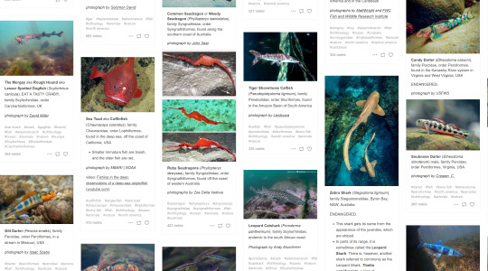
for a truly random experience, browse @hellsitegenetics to see what aquatic wonders are hiding in our posts.
You could also browse the entire tag of #ichthyology, the study of fish
Creature Websites!
Now to sail off tumblr to some of the sites I've browsed in the past, designed to introduce you to new species across the planet. I've narrowed these links down to fish sorted entries, but please browse the rest of the sites for fun as well!
My favorite for many years, The Featured Creature! Make sure to open every article to see the fish in question, as the article previews don't always show that each post has many beautiful photos of beautiful fish

Another archive with dozens of pages of fish spotlights! Check out activewild and see what you can sea
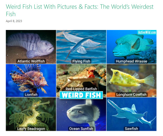
A classic! Check out articles and species spotlights of National Geographic
There's also lots of smaller blogs with only a page or so of fish. Coffeeandcreatures, thewildlife.blog and many many many more!
Start a new bookmarks category, pinterest board, or image folder and just start throwing fish in there. Your ocean of ideas will never run dry.
Not an artist but desperately want to see an obscure mermaid? You can ask me to tackle it! Just make sure you've browsed my mermay tag to make sure I haven't done it in years prior.

Request a mermaid here!
If you're an artist and you used this list to discover a new species, let me know! I love seeing what other people find interesting.
Happy mermay!
#mermay#mermay 2024#shire screams#fish#ithyology#unusual fish#weird fish#fish discovery#reference#tutorial#art tips
656 notes
·
View notes
Text

Manatees gather on the sandy bottom near Homosassa Springs, where the water is warm in winter. Naturally forming warm water inlets were where manatees used to spend the winter, but urban development destroyed their natural hydrology.
Photograph by Jason Gulley, National Geographic Image Collection
#jason gulley#photographer#national geographic#animal#mammal#wildlife#manatees#homosassa springs#nature
56 notes
·
View notes
Photo

National Geographic Image Collection/ Paul Nicklen
61 notes
·
View notes
Text

A new study suggests gray seals (Halichoerus grypus) can sense the level of oxygen in their blood and that the animals change their diving behavior in response. PHOTOGRAPH BY GREG LECOEUR, NAT GEO IMAGE COLLECTION
Excerpt from this National Geographic story:
Seals can do many things humans can’t, of course, but a clever experiment in Scotland has just uncovered a new ability. A study published in Science this week suggests that the marine mammals can sense the amount of oxygen in their blood, and change their diving behavior in response.
All animals extract oxygen from the air they breathe in, and release carbon dioxide (CO2) from their blood in the air they exhale. Most mammals can’t directly detect oxygen levels in the blood supplying their tissues. Instead, they rely on the rising level of CO2 in their blood to signal that they might need to take a breath. Most researchers might have assumed that even excellent divers like seals relied on those signals.
But the new experiments in gray seals show that the animals “flexibly respond to changing oxygen levels, which may be what keeps them from drowning,” says lead author Chris McKnight, a physiologist at the University of St. Andrews in Scotland. If McKnight and his colleagues are correct, this could help explain why human free divers so often black out before they make it to the surface—and it opens the possibility that other diving animals could sense their blood oxygen levels too.
26 notes
·
View notes
Text
Some ff headcanons before i go to hell (yes i moved accounts dont worry)

lycras are kemonomimi, only a bit more evil
due to the biological differences between mortal humans and lycras, chin chin's corrupted chromosomes caused some mortals to devolve into animalistic states (lemon man) or mutate badly enough that anything they were wearing at the moment merge into their skin (Magic man)
Salamander man used to be from a family of great scholars, chin chin didn't like that and corrupted them
tumblr girl purely exists to collect images of them, omniversal national geographic.
Pink guy is definitely genderfluid, this sparks the gang to stare at them until they say her pronouns for the day
Pink guy acts like pearl from SU internally as he isn't able to speak in some realms and tell Frank to STOP
Dade.
Safari man tucks Frank to sleep sometimes
Safari man tried to calm frank down with videos of bill nye on his phone once. He hasn't recovered since.
Safari man is forced to wear an undershirt because of Pink guy to give Frank some "good morals", needless to say it didn't work.
Red Dick and Safari man work together to create some dishes that Frank won't throw up all over the floor over
I am not drawing Prometheus
Magic man still works with red dick... as a gardener
Magic man occasionally works part time as a circus freak to get free food
Magic man is also fake frank, Chin chin just shaved him BALD for this one
Magic man sleeps in cupboards, Red dick gets incredibly pissed at this and sends Prometheus after him
Magic man was one of the few to discover that they could be cured from chin chin's corruption, solely because he wanted his hair back.
Don't worry, i'm already planning to make my own series based on my headcanons after i'm done with finding what i want, i'll come back once in a while but most likely never truly back. Bonus FF oc that i'm reworking on:

7 notes
·
View notes
Text


Lee Johnson, left, with his pony Gypsy in the Clondalkin district of Dublin. Says Abell of this photograph which made the cover of the September 1994 issue of National Geographic, "“They didn't know National Geographic-- clearly I was an American, I had a camera. And courteously, in a state of pure bewilderment, they stopped, stood behind their pony, and stared me down. I couldn't get them not to stare at me. So I composed the picture and I'm waiting, but nothing's gonna happen. And then some friend of theirs went by in a car, honked the horn, and shouted. At that moment a blast of wind hit the horse and hit their hair, a little bit, not much-- and they are looking off camera to see who's shouting at them. Click.”
📸 by Sam Abell, Nat Geo Image Collection
17 notes
·
View notes
Note
hopefully not a weird question with everything that's going on, but do you have any recommendations about what geography toys/resources are best for kids? my little brother's really interested but I don't see him often enough to play globle with him or show him world maps (his favorite games rn) so I thought I'd give him something :} (just wondering if there's a good way to help him learn)
Online resources I'd recommend are sporcle and seterra for quizzes (the no borders blank map ones in sporcle are really fun), and for just looking at maps there's geamap, mapsland, gifex, library of congress, the rumsey historical map collection, the university of cape town, old maps online, the british library, and the national library of australia, there's many more but these are most of the ones in my bookmarks.
If you do want to encourage him to develop an interest in geography as a field of study, I would show him how some online geographical information systems (GIS) work, but I don't think I can link any useful ones because all I know are the GIS managed by the various Spanish institutions and ministries. I'd consider this important because geography is much, much more than memorizing features on a map, even if I've always enjoyed that (and if he's still in primary school/early secondary, it'll definitely be useful to memorize some countries). Those GIS allow you to pick and choose between many layers and a basic set of tools, so even if you're just curious and not in the mood for figuring some connections out, they have a lot more information than the set of printed maps, because not all that information has been actually mapped out and made available on those sites. For example, if you want to see the distribution of land plots where you live, it's simply easier, and probably the only option, to go look at the GIS an administration has made public, like the cadastre or the tax admin, than sleuth through all these sites and Google images for relevant already printed maps.
13 notes
·
View notes
Text
Plant of the day: Black Cherry - Prunus serotina


Today I wanted to recognize a lovely early successional tree species, one of America's showiest "Cherry" species and a vigorous ecological powerhouse
Black cherry has quite the unusual range, commonly found All over the Eastern US but has multiple geographically distinctive subspecies throughout the West and Mexico. North from Minnesota to Nova Scotia south to mid Florida to east Texas, Additionally it can be found in Big Bend National Park, areas of Arizona and New Mexico. South of the border Black Cherry is found throughout the East, West, and South Sierra Madres mountains reaching as far south as Guatemala.
Black Cherry as I've encountered it grows mostly in old fields and disturbed grounds, but apparently in Mexico it occupies mountainous regions. The species is also able to live long enough to be part of some older forests as well. In terms of finding it, If you've ever driven down an Eastern-Midwest highway in May, you'll notice plenty with a stunning display of white flowers (see below). I saw them all the way out to Kansas on Route 70.

This cherry occupies weedy environments very well, usually ending up with twisted bent forms and has an incredibly high germination rate. This vigorous tree can dominate a seed bank for years (I've pulled probably thousands from my garden beds). In Europe-East Asia it is considered a problematic invasive...but here where it's native it can outcompete the worst competition.

Identifying black cherry is rather easy, it has a dark flakey semi-plated bark (below), while the stems are notably cherry like (horizontal fissures) at the stems and intact portions of bark. The heart wood is notably orangish in color and the leaves give off the cherry-like odor when crushed. Leaves are typically longish symmetrical semi-shiny, darkish green with one very visible vein and shallow serated edges. Flowers are white clusters reminiscent of horns present around late May to early June. The ripe fruit is blackish red and present around August, on a good year it's quite plentiful (and delicious).

Black cherry is a wild edible in a few forms. I personally like to snack on the sour ripe fruit and spit out the large seeds, in Mexico these fruits are referred to as cupelines! The most fruitful useage is probably making jelly from collected fruit (something I do not know how to do). Cough syrups were historically derived from the bark and are still present in popular tea flavors such as "throat coats" (awful name).
While marginally edible to us the black cherry is ecologically the most important native cherry species for wildlife. Not only is there plentiful fruit for birds and large mammals the tree is rated number three amoung supported lepidoptera species. Per Doug Tallamy and Kim Shropshire's research the Prunus genus supports [at least] 465 species of invertebrates.

In this vein a common species which inhabits these trees are eastern tent caterpillars (image from inaturalist). I bring them up only because people commonly confuse them for the spongy moth (formerly g*psy moth). But tent caterpillars live in groups and only really eat prunus species whereas spongy moths are devastating and solitary. Interestingly enough the leaves of black cherry contain enough cyanide to make these caterpillars toxic to most predators! Don't break up the tent, tent caterpillars won't kill your tree.
In terms of modern relationships with the tree, people mostly use it as a higher quality cabinetry wood. I believe this species is one of the more common cherry woods to recieve, it has a strong orange hue to its wood which lasts. People also refer this species as an aromatic wood...however having cut down multiple of these trees I hate the smell, fresh cuts are like a chemical cyanide scent...

Lastly I'll bring up causes for decline, lately I've seen a reduction in black cherry due to an introduced fungus called the black knot. This affects many cherry species and isn't always fatal but can kill a tree (hence why I cut down multiple). You can treat individuals if you spot them early by cutting infected branches and burning/burying them before they spore in spring.
Ultimately the Black Cherry is the less famous cousin to the showy Asian cherry cultivars, but still holds a punch of beauty and provides incredibly high ecological value compared to most other American trees. Happy hunting!
12 notes
·
View notes
Text
While they may not look alike, did you know that seals are thought to be most closely related to bears, weasels, and otters? 🦭
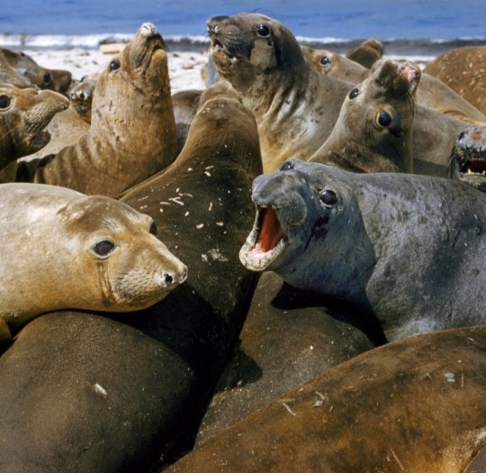
📸 1/4: Barking elephant seals, Mirounga angustirostris, bask in a huge pile on a beach.
(National Geographic Image Collection / Bates Littlehales)
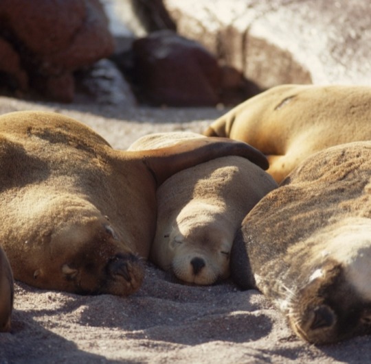
📸 2/4: Seals sleep in a tight group on the beach.
(National Geographic Image Collection / Joseph J. Scherschel)

📸 3/4: A colony of Steller's sea lions (Eumetopias jubata, also called northern sea lions) on a rocky islet in Hecate Strait.
(National Geographic Image Collection / Sam Abell)

📸 4/4: California sea lions, Zalophus californianus, lounge on a rock in British Columbia's Great Bear Rainforest.
(National Geographic Image Collection / Anne Farrar)
#seals#elephant seals#Mirounga angustirostris#sea lions#Stellar's sea lions#northern sea lions#Eumetopias jubata#California sea lions#Zalophus californianus#National Geographic#animals#marine mammals#pinnipeds#fin-footed
43 notes
·
View notes
Text
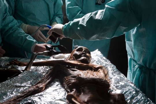
Brain samples are taken from the Copper-Age Mummy Ötzi, who was encased in ice shortly after death. This Natural Mummification preserved the body for some 5,000 years before its discovery in 1991. Photograph By Robert Clark, National Geographic Image Collection
These Mummies Were Made … By Accident?
Freeze-dried, salted, or buried in a bog: Thousands of years before humans intentionally mummified their dead, nature took care of it for them.
— By Elise Cutts | August 7, 2023
A mummy isn’t exactly something one would expect to make by accident.
Left to nature, a human body would usually be reduced to bones within a few years. Mummy-making cultures like the ancient Egyptians were only able to stave off the inevitable thanks to complex funerary practices involving all manner of specialized tools, chemicals, and procedures.
But there are paths to mummified eternity that don’t involve canopic jars, natron salts, or brain-removing hooks. In fact, some of the oldest Egyptian mummies were likely accidents, says Frank Rühli, director of the University of Zurich’s Institute of Evolutionary Medicine and head of the Paleopathology and Mummy Studies Group.
Buried in shallow graves, bodies can be naturally preserved for thousands of years by the dry heat of the Sahara’s desert air and sand. Rühli says he believes this could have inspired ancient Egyptians to start mummifying their honored dead.
Hot deserts are just one of many environments in which corpses naturally mummify. Scientists explain how environments ranging from bogs to icy mountaintops can stave off decay and—with a bit of luck—mummify bodies.
Deserts
The Egyptians aren’t the only desert culture known for their mummies. The Chinchorro people of northern Chile started to intentionally mummify their dead about 2,000 years before the Egyptians—and thousands of years before that, the Atacama Desert was doing it for them.
“One of the things that's interesting about the Chinchorro mummies is that some of them were intentionally prepared, while other were naturally mummified,” says physical anthropologist Bernardo Arriaza of the University of Tarapacá in Chile, who spent his career studying the Chinchorro mummies.
A bone-dry corpse, perhaps ironically, will likely leave more than bones.
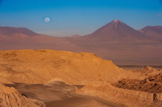
A Landscape of the Desert! The Atacama desert plateau is one of the driest places in the World. Mummies have been found here that predate ancient Egypt’s by 2,000 years. Photograph By Naftali Hilger, Laif/Redux
Decay is a biological process and without water, biology can’t work. This is why deserts preserve bodies so well and why Egyptian and Chinchorro mummification practices involved steps to dry out the body.
The oldest Chinchorro mummy, Acha Man, was naturally preserved by the desert for more than 9,000 years. Natural mummies have been found in deserts around the world. Among the most well-preserved are the Tarim mummies of Xinjiang, China, who were buried in boat-shaped coffins up to 4,000 years ago in the Taklamakan Desert.
Salt
For a handful unfortunate Iranian miners caught in cave-ins at the Chehrabad salt mine, salt did the job just as well as deserts.
"They were working in the salt mine and then it collapsed,” says Rühli, who studied the mummies. This actually happened multiple times—at least twice, says Rühli—over about 1000 years, entombing young men separated from one another by centuries in the salt they’d come to mine. Though the weight of the salt crushed the miners, flattening their corpses, the salty rock drew the water out of their bodies and mummified their squashed remains.
Salts in the dry soils of the Atacama Desert also helped preserve the Chinchorro mummies, says Arriaza. The soils are rich in nitrate compounds, nitrogen, potassium, sodium, calcium. “Mostly salts,” he says. “That's going to help dehydrate the body.”
Ice
Removing the water from a corpse isn’t the only way to stop decay. Low temperatures slow down most biological processes, and freezing a body completely can keep it from rotting for thousands of years.
Pathologist Andreas Nerlich of the Munich Klinik Bogenhausen studied Ötzi, a 5,300-year-old ice mummy who was found poking out of melting glacier ice in the Ötztal alps near the Austrian-Italian border. “They're preserved as long as the ice is there,” he says of mummies like Ötzi.
While “very rare,” adds Nerlich, ice mummies like Ötzi can be remarkably well-preserved compared to dehydrated mummies. That’s because dehydration shrivels and distorts tissues, but frozen organs mostly keep their shape.
Permafrost, earth that remains frozen year-round, can also mummify. One Siberian mummy, the 2,500 year-old Ice Maiden, was quite literally frozen in a block of ice after her burial chamber flooded and the water quickly froze. Because her burial chamber was constructed from permafrost earth, the ice that formed inside never melted.
Freeze-Drying
Combining cold and dry conditions can mummify bodies even when it’s not consistently chilly enough to keep a body frozen year-round. That’s what happened to a handful of Thule Inuit women and children in Greenland. They were naturally mummified in their graves after their deaths, likely caused by famine or disease, in the 15th and 16th centuries.
It’s a bit like natural freeze-drying, says paleopathologist Niels Lynnerup of the University of Copenhagen, who studied the mummies.
“Even though it's very cold in Greenland, it's not like it's in the high Arctic with permafrost,” he says. The bodies were buried under rocky covers or cairns, so “they still had wind blowing through.” The wind desiccated the bodies and, combined with the bacteria-slowing effect of cold temperatures, mummified them.
Many of the Inca mummies discovered high on Andean mountaintops were preserved by freeze-drying, too. The exceptionally well-preserved Maiden of Llullaillaco, the mummy of a teenage Inca girl left to succumb to cold on an Andean mountaintop as a sacrifice, is a unique case as she was frozen solid.
Even the conditions in cool, dry crypts can sometimes preserve remains in a similar way so long as bodies are either well-ventilated or kept under airtight conditions after being dried out, says Nerlich. Several natural mummies in crypts weren’t entirely accidents. One Upper Austrian mummy known as the Luftg’selchter Pfarrer was intentionally stuffed with water-absorbing materials and treated with salts to delay decay temporarily before he naturally mummified in his crypt.
Bogs
Natural mummification almost always involves somehow getting rid of water, either by removing it entirely or turning it into ice. So may be a bit surprising that wet, swampy bogs can preserve human remains for millennia.
The oldest bog mummy is Cashel Man, who was probably killed in a sacrifice around 2,000 B.C. His body was naturally mummified because of the unusual chemical conditions in bogs.
“There are several factors which cause human remains to be mummified in bogs,” says archaeologist Isabella Mulhall of the National Museum of Ireland. “The lack of oxygen, the cool dark environment… the [acidity] levels of the bog also has a role to play.”
A type of moss often found in bogs also helps mummify bodies, Mulhall adds. Sphagnum moss releases an acidic sugary molecule called sphagnan, which takes up the nutrients that would otherwise nourish microbes that cause decay. This helps mummify corpses—though sphagnan also leaches the calcium out of bones, weakening them.
The acidic fluids in bogs chemically alter the body, not unlike leather tanning or pickling. That’s why most bog bodies, no matter how they looked in life, have dark, leathery skin and bright red hair.
Many bog bodies appear to have met rather violent ends—a fate shared with many other natural mummies. But because luck happened to preserve their bodies, the victims of these ancient tragedies can still tell scientists about themselves and their societies. The same processes that mummify human skin and organs can also sometimes preserve undigested food in the stomach, blood, traces of disease-causing microbes, and even clues about the ecosystems and climates that ancient people lived in.
“In a sense,” says Arriaza, “all these ancient remains are time capsules.”
#Science#Copper-Age Mummy Ötzi#Natural Mummification#Robert Clark#National Geographic Image Collection#Freeze-Dried#Salted#Elise Cutts#University of Zurich’s Institute of Evolutionary Medicine#Paleopathology#Frank Rühli#Egyptians#Chinchorro people of Northern Chile 🇨🇱#Atacama Desert 🐪 🌵#Physical Anthropologist Bernardo Arriaza#University of Tarapacá Chile 🇨🇱#Egyptian & Chinchorro Mummification Practices#Acha Man#Taklamakan Desert#Chehrabad Salt Mine#Nitrogen | Potassium | Sodium | Calcium | Salts#Pathologist Andreas Nerlich | Munich Klinik Bogenhausen#Permafrost#Niels Lynnerup | University of Copenhagen#Thule Inuit Women & Children | Greenland 🇬🇱#Isabella Mulhall | The National Museum of Ireland 🇮🇪#Cashel Man
2 notes
·
View notes
Text


bug like an angel collage zine. images from the bug like an angel music video, my pinterest board, 1970s national geographic magazines, and my sticker collection.
#mitski#bug like an angel#blaa#the land is inhospitable and so are we#tliiasaw#original#collage#zine
48 notes
·
View notes
Text

Orcas (pictured, a pod in Norway) are likely the most widespread vertebrate on the planet.
PHOTOGRAPH BY PAUL NICKLEN, NATIONAL GEOGRAPHIC IMAGE COLLECTION
#paul nicklen#photographer#national geographic#orcas#animal#orca pod#norway#vertebrate#nature#marine photography
52 notes
·
View notes
Text

IMAGES: B-2s land in Iceland for the first Bomber Task Force in months
Fernando Valduga By Fernando Valduga 08/14/2023 - 19:31 in Military
Three B-2 bombers from the 509ª Bomber Wing at Whiteman Air Base, Missouri, landed in Keflavik, Iceland, on August 13 to begin the first outward deployment of the stealth bomber since the B-2 fleet's six-month security pause ended in May.
More than 150 aviators along with the three B-2 Spirit aircraft arrived at Keflavik Air Base with the aim of participating in Bomber Task Force (BTF) missions, a vital component of the U.S. European Command (USEUCOM) collaborative training efforts with U.S. Allies, partners and joint forces.

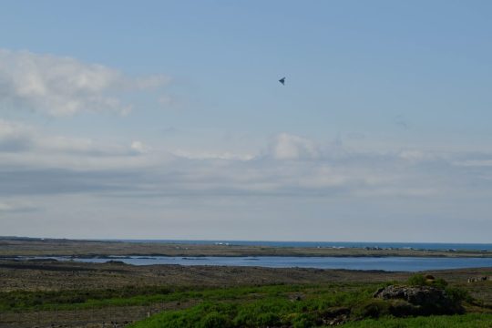
The B-2 is the only operational stealth bomber of the Air Force, with a global range, and the continuous rotations of the Bomber Task Force in Europe are seen as an element of NATO's high alert level since the Russian invasion of Ukraine in early 2022. The planned duration of the recent deployment has not been disclosed, but BTFs usually last from 2 to 6 weeks.
youtube
Around the world, the U.S. Strategic Command routinely orchestrates BTF operations not only to show the United States' commitment to collective defense, but also to integrate seamlessly with the operations conducted by the Geographic Combat Commands of America. This BTF initiative is designed to strengthen USEUCOM's comprehensive security mandates across the European continent, while offering crews the opportunity to acclimatize to the complexities of joint and coalition operations in foreign locations.

"Each mission of the bomber task force highlights the feat of our armed forces in navigating today's intricate and unpredictable terrain of global security, focusing on promoting stability, security and freedom throughout Europe," said General James Hecker, commander of the U.S. Air Forces in Europe; U.S. Air Forces in Africa and NATO Allied Command. "In resolute unity, the U.S. maintains our nation's commitment to promoting peace and stability in Europe, collaborating unwaveringly with allies and partners to prevent challenges against the sovereignty of nations throughout the region."

Leading the crew of the expeditionary bomber in its deployment is Lieutenant Colonel Andrew Kousgaard, commander of the 393º Bombing Squadron. He emphasized the essence of the dynamic use of the force, describing it as a strategy that combines strategic unpredictability with operational adaptability. Lieutenant Colonel Kousgaard said: “The B-2 bomber is arguably the most strategically significant aircraft in the world, but that does not mean it is unftably; dynamically deploying bombers is a unique and important capability.”
The presence of the B-2 at Keflavik Air Base serves as a tangible link between U.S. Air Force personnel and their colleagues in the theater of operations. This connection facilitates collaborative training, increasing interoperability and highlighting the unwavering dedication of the United States to the region.


It has not been disclosed whether B-2s will operate from any advanced area in Europe, but BTFs usually include unannounced secondary deployments.
Elaborating on the importance of joint training exercises with the Allies, Lieutenant Colonel Kousgaard highlighted the role of his unit in improving collective military capabilities and increasing the likelihood of successfully achieving the shared goals. He emphasized: "There is simply no substitute for practical integration with our allies and partners that we can carry out during a BTF deployment like this."

In addition to strengthening combat readiness, the BTF initiative allows aviators to engage in a wide spectrum of military operations, covering everything from combat missions to humanitarian aid and disaster relief efforts.
The Bomber Task Force Europe offers U.S. and NATO leaders strategic options to secure, stop and defend against opposing aggression against the Alliance, throughout Europe and around the world. Regular and routine deployments of U.S. strategic bombers provide our critical touchpoints to train and operate alongside our allies and partners, reinforcing our collective response to any global conflict.
Tags: Military AviationB-2 SpiritBTFUSAF - United States Air Force / U.S. Air Force
Sharing
tweet
Fernando Valduga
Fernando Valduga
Aviation photographer and pilot since 1992, has participated in several events and air operations, such as Cruzex, AirVenture, Daytona Airshow and FIDAE. He has works published in specialized aviation magazines in Brazil and abroad. Uses Canon equipment during his photographic work around the world of aviation.
Related news
MILITARY
Marshall Aerospace receives contract for modification, support and maintenance in South Africa's C-130 fleet
15/08/2023 - 16:00
MILITARY
France concludes software update tests for Reaper drones
15/08/2023 - 14:00
MILITARY
Slovenia authorizes purchase of second transport aircraft C-27J Spartan
15/08/2023 - 13:00
One of the F-117 arriving in Duluth to participate in the Northern Lightning. (Photo: Zach P. Nipper Photography)
MILITARY
IMAGES: F-117A Nighthawk stealth aircraft participate in the Northern Lightning 2023 exercise
15/08/2023 - 08:42
Midnight, an all-electric aircraft from Archer Aviation, is seen at Salinas Municipal Airport in Salinas, California, USA, on August 2, 2023. (Photo: REUTERS/Carlos Barria)
EVTOL
U.S. Marine Corps approaches Archer's eVTOL Midnight aircraft
15/08/2023 - 08:12
MILITARY
Billionaire wants to take a captive orca to freedom in a Hercules aircraft
14/08/2023 - 21:56
homeMain PageEditorialsINFORMATIONeventsCooperateSpecialitiesadvertiseabout
Cavok Brazil - Digital Tchê Web Creation
Commercial
Executive
Helicopters
HISTORY
Military
Brazilian Air Force
Space
Specialities
Cavok Brazil - Digital Tchê Web Creation
23 notes
·
View notes