#MapStory
Explore tagged Tumblr posts
Visit Tumblr Blog
Explore Tumblr blogs with no restrictions, modern design and the best experience.
Last Seen Tumblr Blogs


Fun Fact
Tumblr was created by web developers David Karp and Marco Arment.
Text
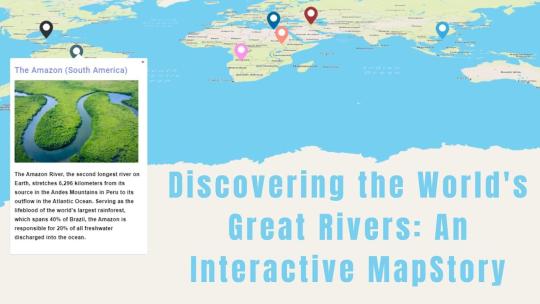
Discovering the World's Great Rivers: An Interactive MapStory
Introduction
Let's dive into the stories of some of the world’s most famous rivers using Story by MAPOG! We’ll look at the Nile, Amazon, Yangtze, Congo, Mississippi, Volga, and Danube rivers. These rivers are more than just water—they’ve shaped cultures, supported wildlife, and influenced history. With MapStory, you’ll get to see how these amazing rivers connect with our world.

The Rivers and Their Stories
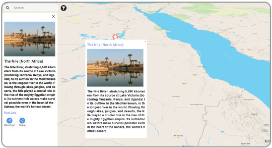
The Nile (North Africa)
The Nile is the longest river in the world. It stretches from East Africa to the Mediterranean Sea. For thousands of years, it’s been crucial for life in North Africa. The Nile provides water for farming and has helped build cities and cultures along its path.
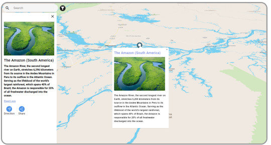
The Amazon (South America)
The Amazon is the largest river by volume. It runs through the Amazon rainforest, known for its incredible wildlife. The Amazon is vital for many plants and animals and plays a big role in regulating the Earth’s weather.
The Yangtze (China)
The Yangtze is the longest river in China. It starts in the Tibetan Plateau and flows to the East China Sea. It’s essential for farming, industry, and millions of people. The Yangtze is deeply connected to Chinese life and culture.

The Congo (Central Africa)
The Congo is Africa’s second-longest river. It’s famous for its rainforests and rich wildlife, like gorillas and elephants. The Congo is key for transportation and trade in Central Africa and helps keep local cultures vibrant.

The Mississippi (North America)
The Mississippi River runs from Minnesota to the Gulf of Mexico. It’s a big part of American history, influencing trade, transportation, and culture. The Mississippi has shaped the lives of many people in the U.S. and inspired music and traditions.

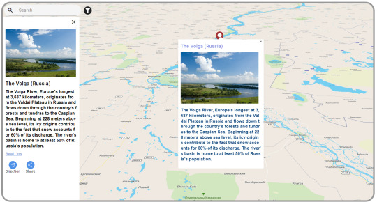
The Volga (Russia)
The Volga is Europe’s longest river. It flows through central Russia and is crucial for farming, energy, and transport. The Volga is important in Russian culture, inspiring many songs and stories.
The Danube (Central and Eastern Europe)
The Danube flows through ten countries, offering stunning views and historic cities like Vienna and Budapest. It’s been a major trade route for centuries and supports diverse wildlife. The Danube helps connect different cultures and economies.

Tool Used: MapStory
We’re using Story by MAPOG to learn about these rivers. It’s not just a map—it’s a way to tell the stories of these rivers and show what makes them unique.
How MapStory Helps
Shows Information: MapStory helps us bring together different details to highlight what makes each river special.
Engages Users: Telling stories through maps makes it easy and enjoyable to learn about the rivers’ history and importance.
Adds Photos: We can include pictures to make the stories about the rivers come to life.
Interactive Map: You can click on the map to find out more about different places and features along each river.
Customizable Stories: Each river’s story can be adjusted to fit various themes and interests, making each map unique.
Who Can Benefit
Story by MAPOG is useful for many areas. Whether you’re interested in environmental studies, education, tourism, cultural preservation, or urban planning, Story by MAPOG offers valuable insights and engaging content. It’s a great tool for anyone curious about these major rivers.
Conclusion
Learning about the world’s great rivers with Story by MAPOG is a fun way to see their beauty and importance. By combining maps with stories, Story by MAPOG helps us connect more with these rivers. For more information or to start your own MapStory journey, visit MAPOG or reach out to us at [email protected].
#GreatRivers#MapStory#MAPOG#NileRiver#AmazonRiver#YangtzeRiver#CongoRiver#MississippiRiver#VolgaRiver#DanubeRiver#InteractiveMap#CulturalHeritage#Wildlife#History#Geography#EducationalTools#Storytelling#Mapping#GlobalRivers#EnvironmentalAwareness#Tourism
1 note
·
View note

Photo

Woohoo! I’ve completed and submitted my map to @risedesignandshine #foliofocus2018 class!! It’s second weeks in this course and I’ve created some of my favourite works! I’ve changed and discovered new way to illustrate a map. This course helped me grow and inspired me to created! ❤️ • • • • • • • #germanyattractions #germany #germanytravel #deutschland #LivWan #theydrawandtravel #googlemap #travelmap #editorialillustration #travel #germanyillustration #berlin #foodmap #mapstory #map #mapart #mappa #illustratedmap #mapillustration #mapillustrator #mapmaker #illo #kidlitart #childrenillustration #childrensbooks #mapbook #childrenillustration
#childrenillustration#berlin#map#kidlitart#germanyattractions#mapart#mapillustrator#germany#germanytravel#travel#mappa#illo#foodmap#childrensbooks#googlemap#germanyillustration#mapstory#theydrawandtravel#foliofocus2018#mapbook#deutschland#editorialillustration#mapillustration#mapmaker#livwan#illustratedmap#travelmap
234 notes
·
View notes
Photo

from nytimes, already 5 day old - an eternity now! - but what an awesome mapstory illustrating the escape-from-wuhan dynamics and clarifying the futility of the contact trace as a containment tactic. NYT 3/27/20
1 note
·
View note
Video
tumblr
Gokarna is a very special place. A completely unique way of experiencing the Beaches. Check the complete trip. http://bit.ly/GokarnaTS
#travelshelf#mapstories#gokarna#gogokarna#mytravelstyle#travel#traveler#travelblog#hills#beahces#hills&beaches#chill#Trekking#explore
0 notes
Text
TeachersFirst Review - MapStory
See on Scoop.it - Informática Educativa y TIC
MapStory reviewed by TeachersFirst, This tool is an interesting way to visualize geographic information by telling it in a story format. You organize knowledge in MapStory by becoming storytellers who create, share, and collaborate. You can help to improve understanding of worldwi
0 notes
Link
Pathstory is an online GPS path-sharing, photo-sharing, and social networking service. Users share their location and take photos over a specified time interval to automatically create maps of their travels, day trips, casual afternoon hangouts, nights out in the city, and more (we call these "stories").
With Pathstory you can create and share stories in real-time, while still having the freedom to choose which moments to show your audience. Stories can also be replayed later for users who miss a live broadcast. Live and completed stories can be shared on existing social media and networking platforms, such as Facebook, Twitter, and WhatsApp.
View startup
0 notes
Text
MapStory celebrates 5 years as an open data community!
It was on April 12, 2012 that Dr. Christopher Tucker first presented the MapStory.org prototype at the Foss4g NA conference in Washington DC. Check out this article from that day which reviews the nascent platform. Over the next five years MapStory.org has worked with over 30 open source developers and over 2,000 beta testers to engineer the MapStory.org beta site that is now live.
Thanks to everyone that lent a hand! Here's to the next five years!
Check out the mapstory below that highlights some of the major events in MapStory history to-date.
0 notes
Photo

REDUCED 2018 Disneyland California Adventure Guide Map Pixar Fest Nemo Toy Story Unbeatable! http://rover.ebay.com/rover/1/711-53200-19255-0/1?ff3=2&toolid=10039&campid=5338273991&item=183190304599&vectorid=229466&lgeo=1
0 notes
Text
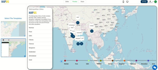
Exploring India’s Metropolitan Cities: MapStories
Introduction
Welcome to our interactive journey through India’s Metropolitan Cities using MapStory! Our goal is to create an engaging, detailed map that highlights the unique stories of India’s major urban centers. We will be exploring cities like Mumbai, Delhi, Bangalore, Chennai, and Kolkata, uncovering their rich cultures, fascinating histories, and dynamic landscapes. With story by MAPOG, we're not just mapping these cities; we're delving into the narratives that make each one special. From bustling markets and iconic landmarks to historical events and cultural traditions, our interactive map will bring the essence of these cities to life.
Tool Used: MapStory
Story by MAPOG is our companion in this exploration. It’s more than just a mapping tool; it’s a platform that blends maps with storytelling. It helps us create interactive narratives that bring to life the essence of India’s metropolitan cities.
How MapStory is Helpful
MapStory allows us to:
Visualize Data: Integrate various data sets to create dynamic maps that reveal cultural diversity, historical landmarks, and urban development.
Engage Audiences: Through storytelling, connect people with the cities, making history and culture more accessible and compelling.
Add Multimedia Elements: Incorporate photos to enrich the storytelling experience and provide a deeper understanding of each city’s unique attributes.
Interactive Features: Users can interact with the map, clicking on different points to learn more about specific locations, events, and cultural highlights.
Customizable Stories: Tailor the appearance and content of each story to fit specific themes and objectives, ensuring that each map is unique and relevant.
Domains That Can Benefit
Story by MAPOG is versatile and can be applied across various domains. Whether it's urban planning, tourism, real estate, environmental studies, transportation, education, cultural preservation, or economic development, MapStory provides valuable insights and engaging content. Its interactive and customizable features make it a powerful tool for professionals, educators, students, and anyone interested in exploring and understanding the dynamic aspects of urban environments.
Conclusion
Exploring India’s metropolitan cities through Story by MAPOG offers a captivating way to understand their dynamic nature and historical roots. By combining mapping with storytelling, MapStory enriches our connection to these cities, making it an invaluable tool across various industries. For more information or to start your own MapStory journey, visit MAPOG or contact [email protected].
#InteractiveMaps#MapStory#IndiaMetropolitanCities#UrbanExploration#Mumbai#Delhi#Bangalore#Chennai#Kolkata#CulturalMapping#HistoricalNarratives#DynamicLandscapes#GeospatialStorytelling#MAPOG#CityStories#UrbanCulture#MappingHistory#EngagingMaps#DataVisualization#MultimediaMapping#UrbanPlanning#Tourism#RealEstate#EnvironmentalStudies#Transportation#Education#CulturalPreservation#EconomicDevelopment#ExploreIndia
1 note
·
View note
Link
Check out this new exercise inMap Story Telling.
Boston’s Snow Journal uses maps, narrative text, images and multimedia to tell the story of how Boston handled its historically snowiest winter earlier this year.
Created by Joyce John, a member of Boston’s Geographic Information Systems team, Snow Journal uses Esri’s ArcGIS platform and JavaScript APIs to incorporate data-heavy maps, photos and videos, statistics, text and narrative to share the city’s story. The interactive interface allows users to explore the data according to their interests.
3 notes
·
View notes
Photo

The lifeline of Indian Travel and Tourism - Indian Railways. Traveling is the journey and destination. The best stories comes from those unplanned stops, dhabas, stations etc. Mark this memories on your trip with Travelshelf and share these with everyone.
Web - https://www.travelshelf.in Android - http://bit.ly/travelshelf #tripstagram #travelstagram #travelholic#travel #tripgram #travelalone #solotravel#travelasia #trip #roundtheworld#maptrails #mapstories #mytravelstyle#travelshelf #travelgram #travelblogger#travelphotography #tripteasers #traveler#ttot #mytavelstyle #travelshelf #wanderer#incredibleindia #backpacking #explorer#wednesdayvibes #lpIndia #NGTIndia#eveningskies
#trip#travel#tripstagram#travelstagram#photography#travelphotography#eveningskies#travelshelf#travelblogging#travelblog#incredibleindia#travelasia#traveling#maptrails#mapstories#explorer#backpacker#backpacking#mytravelstyle#wanderlust#incredibeindia#travelindia#photooftheday#photographers on tumblr#traveler
0 notes
Photo

animated map of New York City with historical boundaries and annexations from 1626 to present @ MapStory
#mapstory#animated maps#new york city#history#storytelling#nyc#new york#usa#america#united states#us history#atlas#mapping links#maps#props
5 notes
·
View notes
Text
Second Blog
by Reynald Dizon
Lorem ipsum dolor sit amet, modus utroque patrioque pro et, in zril maiorum voluptatibus nec. Ad augue qualisque mel, pri vidit ferri in. In idque concludaturque pri. Albucius officiis eu mel, meis ipsum summo ei his, dicit nostrud molestiae has ne. Ipsum ignota scripserit sed ne. Ne appareat intellegat liberavisse nec. Ea per impetus insolens mediocrem, nam et augue placerat, duis congue corpora te eos. Mel ei commodo alterum singulis, eu est quod interpretaris. Ad case propriae elaboraret sea. Ex sit accusam forensibus cotidieque, wisi feugiat omittantur vel ex. Id legere aliquid reprehendunt his. Sea etiam movet putent ad, ad ludus doming eam. At mei etiam option efficiendi, ubique feugait suavitate te eos, mollis tractatos was ei sea. An convenire patrioque signiferumque ius. Omnium impedit te pro. Mea ei minimum salutandi disputationi, animal praesent suscipiantur est id. Graeco aperiri et mei.
0 notes