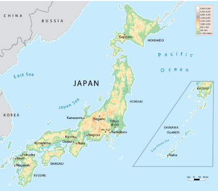
#Kantō Plain
Text
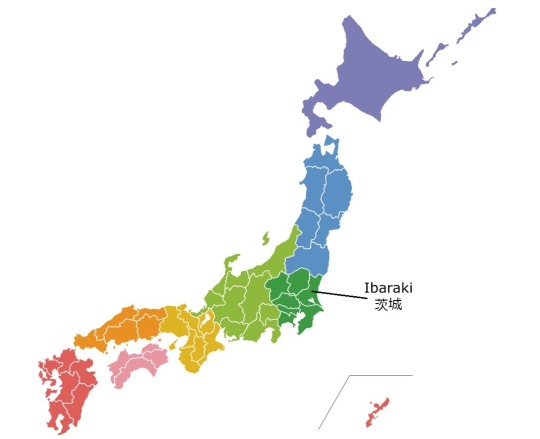
茨城県
Japanese Prefectures: Kantō - Ibaraki
都道府県 (とどうふけん) - Prefectures of Japan
Learning the kanji and a little bit about each of Japan’s 47 prefectures!
Kanji・漢字
茨 いばら、かや、くさぶき、シ、ジ briar, thorn
城 しろ、き、ジョウ castle
県 ケン prefecture
関東 かんとう Kanto, region consisting of Tokyo and surrounding prefectures
Prefectural Capital (県庁所在地) : Mito (水戸市)
Amidst sprawling fields of beautiful flowers, Ibaraki also hosts Tsukuba Science City, Japan's premier research center and the home of Japan's space agency and numerous museums. Ibaraki is known historically for being the home of the Mito branch of the Tokugawa clan during the Edo Period and has long been associated with notable events in Japanese history. The first Nuclear Energy Research Institute was founded here in 1956. You can see space exhibits, actual space craft, and simulations at Tsukuba Space Center.
Outside of the major cities there are many natural areas to explore in the Suigo-Tsukuba Quasi-national Park. Hitachi Seaside Park is famous in the spring for its carpets of blooming blue nemophila. Kairaku-en is one of the Three Great Gardens of Japan. Mt. Tsukuba is a famous night view spot with a view of the Kanto Plain, including Tokyo Tower and the Tokyo Sky Tree, with a ropeway for convenient access. Ibaraki is also a major producer of natto.
Recommended Tourist Spot・おすすめ観光スポット
Fukuroda Falls (Fukuroda no Taki) - 袋田の滝
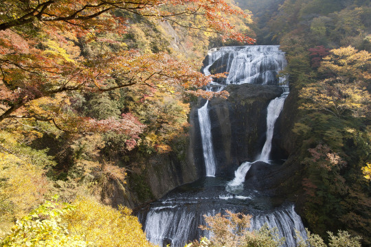
Photo by Own work, CC BY 3.0, Link
One of the three most beautiful waterfalls in Japan, Fukuroda Falls is a 120-meter tall cascading waterfall in northwestern Ibaraki Prefecture in the remote hills of the town of Daigo. It is also on the registered list of the Top 100 Waterfalls of Japan (determined by the Ministry of Environment). These falls are also called the Yodo Falls (Yodo no Taki) because the water stream falls on four large rock faces. It is also said that the renowned monk Saigyo Hoshi greatly praised the falls by saying that you should view the different beauty of the falls in all four (yo) seasons.
They are particularly attractive in early November with the peak autumn foliage as well as peak water flow. There are several different views of the waterfall, and you cannot view it in its entirety all at the same time. Within the Fukuroda Waterfall complex there are neon tunnels and elevators to take you to different levels and viewing platforms. It is said that you will be successful in love if you find a heart in the waterfall. There are also numerous hot springs nearby.
Regional Cuisine - 郷土料理
Monkfish Hot Pot - あんこう鍋

Photo by yosshi / CC BY-SA 2.0
The monkfish (also referred to as angler fish, goosefish, depending on the source I found) is a prized delicacy of Ibaraki and is best eaten fresh. Because these fish are too soft and slimy to cut up on a chopping board, they are prepared using the traditional tsurushi-giri technique, which involves cutting up the fish while suspended from a hook. In Japan, almost all parts of the monkfish are eaten, including fins, skin, gills, liver, stomach, ovaries and flesh—referred to as the “seven tools of the monkfish” in Japanese. The steamed liver is called ankimo and is considered a delicacy that may be eaten alone, or added to the hotpot soup for extra flavor. Anko nabe (monkfish hot pot) is a seasonal favorite consisting of monkfish, vegetables, and flavored broth.
Ibaraki Dialect・Ibaraki-ben・茨城弁
りんごあっけ? ringo akke?
Standard Japanese: りんごありますか? (ringo arimasu ka?)
English: Do you have any apples?
あしにあおなじみできちった ashi ni aonajimi dekichitta
Standard Japanese: 足に青あざができちゃった (ashi ni aoaza ga dekichatta)
English: I have a bruise on my leg
ごじゃっぺなやつだ (gojyappe na yatsu da)
Standard Japanese: いい加減な人; やくにっ立たない人
(iikagen na hito; yaku ni tatanai hito)
English: He's a good-for-nothing person
「行ってもいがっぺ?」 (itte mo igappe?)
「来たらいがっぺ」 (kitara igappe)
Standard Japanese: 「行ってもいいですか?」 「来てもいいですよ」
("itte mo ii desu ka?" "kite mo ii desu yo")
English: "Is it alright if I come?" "Yes please come"
あれは犬だっぺ (are wa inu dappe)
Standard Japanese: あれは犬です (are wa inu desu)
English: That is a dog
いがい車だな (igai kuruma da na)
Standard Japanese: 大きい車ですね (ookii kuruma desu ne)
English: That's a big car, isn't it
杖がおっちょれる (tsue ga occhoreru)
Standard Japanese: 杖が折れた (tsue ga oreta)
English: The cane broke in half
カラスををおっとばす (hato o ottobasu)
Standard Japanese: カラスを追い払う (hato o oiharau)
English: Drive away the crows
その日、大事? (sono hi, daiji?)
Standard Japanese: その日、大丈夫? (sono hi, daijyoubu?)
English: Is that day ok for you?
#japanese prefectures#日本語#japanese#japanese language#japanese langblr#langblr#studyblr#都道府県#茨城県#ibaraki
76 notes
·
View notes
Text

下野[Shimotsuke]
Spiraea japonica
A long, long time ago, there was a region called 毛野[Keno|Kenu] in the northern part of the present Kantō region. As time went by, around the 6th to 7th century, it was divided into two regions, 上毛野[Kami-tsu Keno|Kenu] in the west and 下毛野[Shimo-tsu Keno|Kenu] in the east. Then, in the Heian period(794-1185), these became 上野国[Kamitsuke-no kuni|Kōzuke-no kuni] and 下野国[Shimotsuke-no kuni], and in the Meiji period(1868-1912), they became present 群馬県[Gunma ken] and 栃木県[Tochigi ken], respectively. 国 means province or country, 県 means prefecture. And, this plant got its name because it was found there.
https://en.wikipedia.org/wiki/Ryōmō_Line
利根川[Tonegawa], which flows through the Kantō Plain, is the second longest river with the largest basin area in Japan, and its longest tributary is 鬼怒川[Kinugawa]. 川[-gawa|Kawa] means river. Kinugawa originates in the northern part of Tochigi Prefecture and runs through the prefecture from north to south and empties into Tonegawa. 鬼怒[Kinu] literally means the oni(ogre) gets angry, but this is an ateji(phonetic-equivalent characters), and Kinugawa was originally 毛野川[Kenugawa].
Incidentally, if 下野 is read as geya, it means to leave the government service. This is short for 野に下る[Ya ni kudaru](lit. go down to the private sector) and is not related to Shimotsuke.
22 notes
·
View notes
Photo

Great Kantō earthquake (1923) and the Massacres
The Great Kantō earthquake struck the Kantō Plain on the main Japanese island of Honshū at 11:58:44 JST (02:58:44 UTC) on Saturday, September 1, 1923. Varied accounts indicate the duration of the earthquake was between four and ten minutes. Extensive firestorms and even a fire whirl added to the death toll. The Kantō Massacre began on the day of the earthquake. The earthquake had a magnitude of 7.9 on the moment magnitude scale with its focus deep beneath Izu Ōshima Island in Sagami Bay. Estimated casualties totalled about 142,800 deaths, including about 40,000 who went missing and were presumed dead.
Because the earthquake struck when people were cooking meals, many were killed as a result of large fires that broke out. Fires started immediately after the earthquake. Some fires developed into firestorms that swept across cities. Many people died when their feet became stuck on melting tarmac. The single greatest loss of life was caused by a fire whirl that engulfed the Rikugun Honjo Hifukusho in downtown Tokyo, where about 38,000 people were incinerated after taking shelter there after the earthquake. The earthquake broke water mains all over the city, and putting out the fires took nearly two full days until late in the morning of September 3.
A strong typhoon centered off the coast of the Noto Peninsula in Ishikawa Prefecture brought high winds to Tokyo Bay at about the same time as the earthquake. These winds caused fires to spread rapidly.
Many homes were buried or swept away by landslides in the mountainous and hilly coastal areas in western Kanagawa Prefecture; about 800 people died. A collapsing mountainside in the village of Nebukawa, west of Odawara, pushed the entire village and a passenger train carrying over 100 passengers, along with the railway station, into the sea.
The RMS Empress of Australia was about to leave Yokohama harbor when the earthquake struck. It narrowly survived and assisted in rescuing 2000 survivors. A P&O liner, Dongola, was also in the harbor at the moment of disaster and rescued 505 people, taking them to Kobe.
A tsunami with waves up to 10 m (33 ft) high struck the coast of Sagami Bay, Bōsō Peninsula, Izu Islands, and the east coast of Izu Peninsula within minutes. The tsunami caused many deaths, including about 100 people along Yui-ga-hama Beach in Kamakura and an estimated 50 people on the Enoshima causeway. Over 570,000 homes were destroyed, leaving an estimated 1.9 million homeless. Evacuees were transported by ship from Kantō to as far as Kobe in Kansai. The damage is estimated to have exceeded US$1 billion (or about $16 billion today). There were 57 aftershocks.
Ethnic Koreans were massacred after the earthquake. The Home Ministry declared martial law and ordered all sectional police chiefs to make maintenance of order and security a top priority. A false rumor was spread that Koreans were taking advantage of the disaster, committing arson and robbery, and were in possession of bombs. Anti-Korean sentiment was heightened by fear of the Korean independence movement.
In the confusion after the quake, mass murder of Koreans by mobs occurred in urban Tokyo and Yokohama, fuelled by rumors of rebellion and sabotage. The government reported that 231 Koreans were killed by mobs in Tokyo and Yokohama in the first week of September. Independent reports said the number of dead was far higher, ranging from 6,000 to 10,000. Some newspapers reported the rumors as fact, including the allegation that Koreans were poisoning wells. The numerous fires and cloudy well water, a little-known effect of a large quake, all seemed to confirm the rumors of the panic-stricken survivors who were living amidst the rubble. Vigilante groups set up roadblocks in cities, and tested civilians with a shibboleth for supposedly Korean-accented Japanese: deporting, beating, or killing those who failed. Army and police personnel colluded in the vigilante killings in some areas. Of the 3,000 Koreans taken into custody at the Army Cavalry Regiment base in Narashino, Chiba Prefecture, 10% were killed at the base, or after being released into nearby villages. Moreover, anyone mistakenly identified as Korean, such as Chinese, Ryukyuans, and Japanese speakers of some regional dialects, suffered the same fate. About 700 Chinese, mostly from Wenzhou, were killed. A monument commemorating this was built in 1993 in Wenzhou.
In response, the government called upon the Japanese Army and the police to protect Koreans; 23,715 Koreans were placed in protective custody across Japan, 12,000 in Tokyo alone. The chief of police of Tsurumi (or Kawasaki by some accounts) is reported to have publicly drunk the well water to disprove the rumor that Koreans had been poisoning wells. In some towns, even police stations into which Korean people had escaped were attacked by mobs, whereas in other neighborhoods, civilians took steps to protect them. The Army distributed flyers denying the rumor and warning residents against attacking Koreans, but in many cases, vigilante activity only ceased as a result of Army operations against it. In several documented cases, soldiers and policemen participated in the killings, and in other cases, authorities handed groups of Koreans over to local vigilantes, who proceeded to kill them.
12 notes
·
View notes
Text
Research - Japan's Geography and History
Throughout its history, when confronted with major turning points, Japan relocated its political centre as a means of political reform in order to achieve what was thought to be required and to build a new governing system appropriate for the new age. In the 17th century, at the time of the Meiji Restoration, the ruling class renamed Edo as Tokyo and selected it as the capital of the new nation they intended to build, rather than Kyoto where old traditions and customs remained prominent. The ruling class established a centralised regime based in Tokyo
What's important to note is that the capitol moved to the Kanto Plain of Japan. This was the population centre and had the largest area of agricultural flat land, which made central governance easier.
The Kanto Plain surrounds the city of Tokyo. The plain is located to the east of the Japanese mountain arc, where it bends from a north-south trend to an east-west direction, and is walled by mountains (north and west) and hills (south). The geologic structure of the youngest rock formations accords with this surface expression, and the plain is often referred to as the Kantō structural basin.
Agriculture in this area consists of crops that can grow without irrigation. The upstream reaches of the valleys are gravelly and rather dry, while the central and downstream portions become deltaic, wet, and swampy.
It is the largest plain in Japan and was, when it was fully developed in the Edo period, the richest agricultural area. During the Edo period when agriculture was the strongest part of the economy, this gave the rulers of the Kanto Plain far more wealth and power than any other feudal lords. In the industrial period, the Kanto Plain with its large cities of Tokyo, Yokohama, Kawasaki and Chiba has been the center of urban and industrial growth.

0 notes
Text
Land of Japan:
youtube

-Taishō Pond in Kamikōchi Valley, central Honshu, Japan. Mount Hotaka behind.
The mountain arcs correlate to Japan's primary physiographic regions: Hokkaido, Northeastern (Tōhoku), Central (Chūbu), and Southwestern—as well as the Ryukyu and Bonin archipelagoes. The Chishima and Karafuto arcs merged to form the Hokkaido region. The backbone of the area runs north to south. The Chishima arc reaches Hokkaido as three volcanic chains with altitudes exceeding 6,000 feet (1,800 metres), which form a ladder and finish in the region's core. The Kitami Mountains in the north and the Hidaka Range in the south are the mountain system's main components.
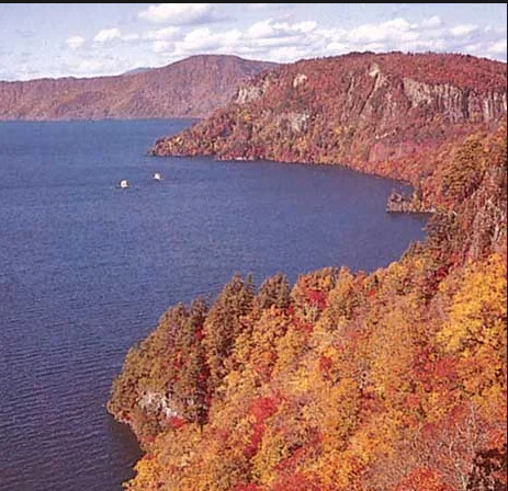
-Lake Towada, Towada-Hachimantai National Park, northern Honshu, Japan.
The Northeastern Region runs from southwest Hokkaido to central Honshu, almost paralleling the northeastern mountain arc. Several rows of mountains, valleys, and volcanic zones are closely aligned with the insular arc of this region, which is convex towards the Pacific Ocean. The Kitakami and Abukuma mountains on the east coast deviate from the normal trend; they are primarily formed of older rocks, with plateau-like landforms surviving in the core. In the western zone, the formations follow the overall trend and consist of a basement complex overlain by thick accumulations of young rocks that have undergone modest folding. The East Japan Volcanic Belt includes the Ōu Mountains, which are separated from the coastal ranges by the Kitakami-Abukuma lowlands to the east and a succession of basins to the west.
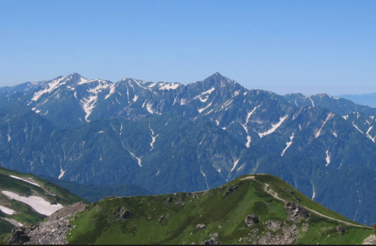
-The Hida Range, part of the Japanese Alps, in central Honshu, Japan.
The Central Region in central and western Honshu is defined by the convergence of the Northeast, Southwest, and Shichito-Mariana mountain ranges around Mount Fuji. The mountain, lowland, and volcanic zones form a nearly right-angled pattern over the island. The Fossa Magna, a massive rift valley that runs from the Sea of Japan to the Pacific, is the most remarkable physical feature on Honshu. It is largely covered by mountains and volcanoes from the southern section of the East Japan Volcanic Belt. Intermontane basins are located between the partly glaciated Akaishi, Kiso, and Hida mountains (Japanese Alps) to the west and the Kantō Range to the east. The Kantō Plain, located east of the Kantō Range, is Japan's largest lowland. Tokyo, the country's largest metropolis, occupies a significant portion of the plain.

-Coast of the Inland Sea, Okayama prefecture, Japan.
The Southwestern Region, which comprises western Honshu (Chūgoku), Shikoku, and northern Kyushu, largely correlates with the southwestern mountain arc. The overall tendency of highlands and lowlands is broadly convex towards the Sea of Japan. The area is separated into two zones: the inner zone, generated by complicated faulting, and the outer zone, formed by warping. The Inner Zone is mostly made up of ancient granites, Paleozoic rocks (250 to 540 million years old), and geologically more recent volcanic rocks that are placed in complex juxtapositions. The Outer Zone, which includes the Akaishi, Kii, Shikoku, and Kyushu mountain groups, is distinguished by a consistent zonal arrangement from north to south of crystalline schists and Paleozoic, Mesozoic (65 to 250 million years old), and Cenozoic formations. The Inner Zone, focused on the Chūgoku Range, has a complex mosaic of fault blocks, whereas the Outer Zone is continuous except for sea straits that divide it into four autonomous groupings. The Inland Sea (Seto-naikai) is the location with the most depression, resulting in seawater incursion. The northern margin of the Inner Zone is studded with massive lava domes generated by Mount Dai, which, along with volcanic Mount Aso, conceal a large portion of the western extension of the Inland Sea in central Kyushu.
-The caldera of Mount Aso in central Kyushu, Japan
The Ryukyu Islands Region comprises the majority of the Ryukyu arc, which extends into Kyushu as the West Japan Volcanic Belt and ends with Mount Aso. The arc's effect may be observed in the pattern of elongated islands off western Kyushu, such as Koshiki, Gotō, and Tsushima. The Izu-Ogasawara Region, to the east of the Ryukyu arc, consists of a series of volcanoes on the undersea ridge of the Izu-Marina arc, and the Bonin Islands, which include Peel Island and Iwo Jima.
Havard referencing:
The Editors of Encyclopaedia Britannica. (1998). The major physiographic regions. [Online]. britannica. Last Updated: 27 October 2023.. Available at: https://www.britannica.com/place/Japan/Soils [Accessed 19 February 2024].
1 note
·
View note
Text
On this day in Wikipedia: Friday, 1st September
Welcome, Willkommen, नमस्ते, Välkommen 🤗
What does @Wikipedia say about 1st September through the years 🏛️📜🗓️?

1st September 2022 🗓️ : Death - Yang Yongsong
Yang Yongsong, Chinese major general (b. 1919)
"Yang Yongsong (simplified Chinese: 杨永松; traditional Chinese: 楊永松; pinyin: Yáng Yǒngsōng; July 1919 – 1 September 2022) was a Chinese military officer, who was a founding major general in the People's Liberation Army. Born in Baihou in Dabu County, Guangdong, he joined the Communist Youth League of..."
1st September 2018 🗓️ : Death - Randy Weston
Randy Weston, American jazz pianist and composer (b. 1926)
"Randolph Edward "Randy" Weston (April 6, 1926 – September 1, 2018) was an American jazz pianist and composer whose creativity was inspired by his ancestral African connection.Weston's piano style owed much to Duke Ellington and Thelonious Monk, whom he cited in a 2018 video as among pianists he..."

Image licensed under CC BY-SA 2.0? by Bob Travis Casco, Maine, USA
1st September 2013 🗓️ : Death - Gordon Steege
Gordon Steege, Australian soldier (b. 1917)
"Air Commodore Gordon Henry Steege, DSO, DFC (31 October 1917 – 1 September 2013) was a senior officer and pilot in the Royal Australian Air Force (RAAF). He became a fighter ace in World War II, credited with eight aerial victories, and led combat formations at squadron and wing level. Born in..."

Image by Hurley, James Francis (Frank)
1st September 1973 🗓️ : Event - Irish Sea
A 76-hour multinational rescue effort in the Irish Sea resulted in the deepest sub rescue in history (pictured).
"The Irish Sea is an extensive body of water that separates the islands of Ireland and Great Britain. It is linked to the Celtic Sea in the south by St George's Channel and to the Inner Seas off the West Coast of Scotland in the north by the North Channel. Anglesey, North Wales, is the largest island..."

Image by
Irish_Sea_4.82844W_53.54821N.png: NASA
derivative work: Dr Greg
1st September 1923 🗓️ : Event - 1923 Great Kantō earthquake
The Great Kantō earthquake devastates Tokyo and Yokohama, killing about 105,000 people.
"The Great Kantō earthquake (関東大地震, Kantō dai-jishin; Kantō ō-jishin) struck the Kantō Plain on the main Japanese island of Honshū at 11:58:44 JST (02:58:44 UTC) on Saturday, September 1, 1923. Varied accounts indicate the duration of the earthquake was between four and ten minutes. Extensive..."

Image by unknown 不明
1st September 1818 🗓️ : Birth - José María Castro Madriz
José María Castro Madriz, Costa Rican lawyer and politician, 1st President of Costa Rica (d. 1892)
"José María Castro Madriz (1 September 1818 – 4 April 1892) was a Costa Rican lawyer, academic, diplomat, and politician. He served twice as President of Costa Rica, from 1848 to 1849, and from 1866 to 1868. On both occasions he was prevented from completing his term of office by military coups...."

Image by Aquiles Bigot
1st September 🗓️ : Holiday - Christian feast day: Terentian (Terrence)
""Terentian" can refer to anything pertaining to the works of Terence.Saint Terentian(us) (Italian: San Terenziano) (died 118) was Bishop of Todi who was killed during the reign of Hadrian (117–138). ..."
0 notes
Text
Japan

Japan, island country lying off the east coast of Asia. It consists of a great string of islands in a northeast-southwest arc that stretches for approximately 1,500 miles (2,400 km) through the western North Pacific Ocean. Nearly the entire land area is taken up by the country’s four main islands; from north to south these are Hokkaido (Hokkaidō), Honshu (Honshū), Shikoku, and Kyushu(Ky…
View On WordPress
#Abe Shinzo#article#Asia#Bonin#britannica#Buddhism#China#Chinese writing#East China Sea#encyclopeadia#encyclopedia#environmental pollution#flag of Japan#Hokkaido#Holocene#Honshu#Izu#japan#Kantō Plain#Korea Strait#Kuril Islands#Kyōto#Kyushu#La Perouse (Sōya) Strait#Mount Fuji#Nara#Naruhito#North Korea#Okinawa#Ōsaka
0 notes
Text
Tokyo : A city of contrasting beauty
Tokyo is one of the 47 prefectures of Japan, and is both the capital and largest city of Japan. The Greater Tokyo Area is the most populous metropolitan area in the world. It is the seat of the Emperor of Japan and the Japanese government. Tokyo is in the Kantō region on the southeastern side of the main island Honshu and includes the Izu Islands and Ogasawara Islands. Formerly known as Edo, it has been the de facto seat of government since 1603 when Shogun Tokugawa Ieyasu made the city his headquarters. It officially became the capital after Emperor Meiji moved his seat to the city from the old capital of Kyoto in 1868; at that time Edo was renamed Tokyo.
Tokyo is often referred to and thought of as a city, but is officially known and governed as a "metropolitan prefecture", which differs from and combines elements of both a city and a prefecture; a characteristic unique to Tokyo. The Tokyo metropolitan government administers the 23 Special Wards of Tokyo (each governed as an individual city), which cover the area that was formerly the City of Tokyo before it merged and became the subsequent metropolitan prefecture in 1943. The metropolitan government also administers 39 municipalities in the western part of the prefecture and the two outlying island chains. The population of the special wards is over 9 million people, with the total population of the prefecture exceeding 13 million. The prefecture is part of the world's most populous metropolitan area with upwards of 37.8 million people and the world's largest urban agglomeration economy. The city hosts 51 of the Fortune Global 500 companies, the highest number of any city in the world. Tokyo ranked third in the International Financial Centres Development IndexEdit. The city is also home to various television networks like Fuji TV, Tokyo MX, TV Tokyo, TV Asahi, Nippon Television and the Tokyo Broadcasting System.
Tokyo ranked third in the Global Economic Power Index and fourth in the Global Cities Index. The city is considered an alpha+ world city—as listed by the GaWC's 2008 inventory —and in 2014, Tokyo was ranked first in the "Best overall experience" category of TripAdvisor's World City Survey (the city also ranked first in the following categories: "Helpfulness of locals", "Nightlife", "Shopping", "Local public transportation" and "Cleanliness of streets"). In 2013, Tokyo was named the third most expensive city for expatriates, according to the Mercer consulting firm,[12] and the world's most expensive city, according to the Economist Intelligence Unit's cost-of-living survey. In 2015 Tokyo was named the Most Liveable City in the world by the magazine Monocle. The Michelin Guide has awarded Tokyo by far the most Michelin stars of any city in the world. Tokyo hosted the 1964 Summer Olympics, the 1979 G-7 summit, the 1986 G-7 summit, and the 1993 G-7 summit. Tokyo will host the 2020 Summer Olympics and the 2020 Summer Paralympics.
A man sits on the stairs at the underpass of an office building in Tokyo.
A man in soiled business clothes leans in the corner of a subway underpass in Tokyo.
Homeless people take shelter on an underpass at a station in Tokyo.
A policeman stands guard at an entrance to the health ministry which is connected to a subway station, in Tokyo.
A man takes a nap on a platform of a subway station in Tokyo.
A construction worker descends on an escalator at a subway station in a banking district in central Tokyo.
People ride on escalators at a subway station in Tokyo.
A station worker looks at posters of disputed islands known as Senkaku in Japan and Diaoyu in China, made by the Tokyo metropolitan government at a subway station in Tokyo September 13, 2012. The sentence on top of the poster reads, "We are being called on to have the courage to say that this island is Japanese territory."
#Tokyo#Saitama#Natural environment#Kantō region#Kantō Plain#Japan Meteorological Agency#Japan#Gunma Prefecture#Greater Tokyo Area#General contractor#Fukaya
0 notes
Photo

A reprint of 'Fireflies on the Kinugawa' (a colour woodblock print, published c. 1930 by the Shima Art Company) by Kobayashi Kiyochika (小林 清親, 1847 - 1915), a Japanese ukiyo-e artist, best known for his colour woodblock prints and newspaper illustrations.
Kinugawa River, Kinugawa, or Kinu River (鬼怒川, Kinu-gawa), is a river on the main island of Honshu in Japan. It flows from the north to the south on the Kantō plain, merging with Tone River (利根川, Tone-gawa). At 176.7 km in length, it is the longest tributary of the Tone-gawa. From ancient times, it has been known to cause floods. The river starts in Kinu swamp in the city of Nikkō, Tochigi, within Nikkō National Park.
[Jaded in Japan]
* * * *
“I would like not minding, whatever travels my heart. To follow it all the way into leaf-form, bark-furl, root-touch, and then keep walking, unimaginably further.”
— Jane Hirshfield, from “Metempsychosis”
[alive on all channels]
#'Fireflies on the Kinugawa'#Jaded in Japan#Kobayashi Kiyochika#transformation#Jane Hirschfield#poem#poetry#Alive On All Channels#words and writing#further
11 notes
·
View notes
Note
What were Okita’s kenjutsu teaching methods that made him to be known for being cruel and harsh?
Hi, thanks for asking!
I wasn’t able to find specific details about his teaching methods, but he’s often described to have been a strict and demanding teacher.
shinsengumi-no-makoto:
He was also known to have been short-tempered when training. Once inside a dojo his students feared him more than Kondo because of his strict and rough manner. He was very particular about swordsmanship and that made it hard for his students to please him. It is speculated that since he was so skilled, he may have had trouble understanding human clumsiness and weakness without ability.
There’s an anecdote about a time when he lost his temper. It didn’t happen during training, but it shows how he could be violent when he was angry:
japanese-wiki-corpus:
Sakuma Shozan’s son, Miura Keinosuke, had been made fun of by a fellow Shinsengumi officer. There is a story that a few days later, Hijikata and Okita were playing a game of Go when Miura attacked the officer who had made fun of him from behind and Okita, infuriated by the cowardly attack, grabbed Miura by the collar and, calling him a 'bloody idiot', pushed his face into the floor until his nose was raw.
Maybe he was also like that when he ran out of patience with someone during training. That would explain his reputation for being cruel and harsh.
To get a clearer image of what his teaching methods were like, here’s what I’ve read about his swordstyle, the Tennen Rishin-ryu:
bakumatsu-ishin:
The Tennen Rishin-ryu took their fights seriously even in practice, and some moves involved suddenly slashing at the opponent’s legs.
The Tennen Rishin-ryu actually still exists.

source: https://www.tennenrishinryu.net/lineage#page-content
And they have a website. Here’s what they say about themselves:
tennenrishinryu:
Gekiken – Tennen Rishin Ryū’s original training method
Simply speaking, gekiken (literally “striking sword”) is a full-contact training system with bōgu (body armor) and shinai (bamboo sword) and is considered the predecessor of modern Kendō. With this term, we are not referring to the “sportified” kenjutsu found in the early Meiji Era (1868-1912), where financially devastated samurai families’ heirs performed in front of audiences in order to make a living; rather, we are speaking in regard to the training system that developed in the Kantō plain during the mid-18th century, that put an emphasis on reproducing real combat situations by allowing for practitioners to freely strike each other at will without fear of permanent injury.
In terms of techniques, variety, and depth Tennen Rishin Ryū isn’t that special: it’s just an old Kendō school meant to strengthen both the body and mind through intense, free sparring.
Such a statement might upset many Shinsengumi fans; however, Tennen Rishin Ryū is not about swinging a sword with movielike elegance. Kondō Isamu, Hijikata Toshizō, and Okita Sōji were strong because they practiced hard and diligently every single day.
One might ask, what the difference is between it and modern Kendō – Well, Kendō is a wonderful art that has raised Japanese swordsmanship to new levels – where both speed and timing are worshipped by limiting strikes on men, dō, kote (gauntlet) and tsuki (thrusting to the throat). Thus, it is considered a safer practice. However, Gekiken is the opposite – it has no restrictions regarding where strikes are allowed on an opponent. Said differently, gekiken teaches how to strike body parts that are not protected by armor. This is because a samurai was expected to fight for and risk his life for his lord on the battlefield wearing a full set of armor. Consequentially, the purpose of gekiken is to resemble real combat situations as much as possible.
And here’s an article where the author describes his day at a Tennen Rishin-ryu dojo:
budojapan:
We started our practice at the Bujutsu Hozonkai with bokuto-no-kirikaeshi, a warm-up exercise where partners run towards each other doing kiai, strike three times at men level and retreat. It sounds easy but doing it with Tennen Rishin-ryu’s 100cm/3’2” long, 6cm/2.3” thick and 2kg/4.5lbs heavy bokuto and with kiai coming and going makes it quite exhausting –which is exactly the purpose! From there on, we moved to the first kata of the school’s Kenjutsu Omote, called “Jochuken”, again performed with the big bokuto. In Jochuken, shitachi in seigan approaches uchitachi who is in jodan, they attempt a mutual men cut, disengage and return for a second mutual men; this time shitachi pushes uchitachi who retreats to jodan and shitachi closes the distance and finishes with a solar plexus thrust. This is classic kenjutsu but like the warm-up, the extra-heavy, extra-thick bokuto makes it quite challenging!


The next thing we did before wearing the bogu (which, incidentally in Tennen Rishin-ryu also includes under-hakama shin protectors: shins are also targets) was “Yokozuki” from Mokuroku’s “Kogusoku” section. Here, shitachi blocks with his kodachi uchitachi’s sword and then grabs both uchitachi’s arms and brings him down illustrating how natural is the passage from armed to unarmed techniques. Kato sensei was kind enough to demonstrate several variations to what follows the take-down, explaining that during free sparring, practitioners are encouraged to use whatever feels appropriate each time.

Practice continued with various techniques from different parts of Tennen Rishin-ryu’s curriculum: First from Kirigami (first level) were “Sen-no-koto” (men strike from jodan), “O-no-koto” (deflecting a men strike), “Shiaiguchi” (a sequence of mune tsuki, three kendo-style kirikaeshi, another mune tsuki and a final mune tsuki from jodan) and “Soi-kirikaeshi” (kendo kirikaeshi but with ayumiashi footwork); as is obvious, in Tennen Rishin-ryu tsuki isn’t limited to the throat like in kendo but can also target mune and the face –and the latter can be really nasty!

Then, from Chugokui Mokuroku followed “Oken” (uchitachi strikes at shitachi’s left kote when he’s in jodan; shitachi lets go of the left hand and strikes men with the right), “Hienken” (both are in jodan, shitachi deflects uchitachi’s men and strikes do while stepping out of range -and possibly kneeling), “Muitsuken” with shitachi holding the blade part of the shinai, in mugamae (regular stance with the shinai held horizontally in the front) from where he uses it to block a men attack either directly from the front or moving to the side, hitting uchitachi’s wrist and following with a powerful jukendo-style two-handed tsuki to the face or blocking and then grabbing both uchitachi’s arms in his armpit like the technique used in Yokozuki with the kodachi, and “Ten-chi-jin” where shitachi also holds the shinai with his two hands but in naname-no-gedan kamae –this is a side stance where shitachi tries to hide the shinai and at some point whips it like an arrow towards uchitachi’s inner kote or face.


The final technique, Otaiken, came from Menkyo and it was a more realistic reaction to kendo’s tsuba-zeriai: shitachi pushes uchitachi’s kote away and strikes men with the other hand while pulling back –simple and extremely effective!

From these articles, we can see that Okita’s teaching style probably involved a lot of sparring without restrictions. From what’s written about his personality, he probably didn’t know how to hold back in a fight and pushed his students too hard, only to lose his temper when they failed to meet his expectations. That could have caused his students to call him cruel and harsh.
19 notes
·
View notes
Photo

'Jūmantsubo Plain at Fukagawa Susaki' (深川州崎十万坪), print 107 from "One Hundred Famous Views of Edo" (名所江戸百景), Part 4 - Winter (冬) by Japanese ukiyo-e artist of the Meiji period Utagawa Hiroshige (歌川 広重, 1797-1858), born Andō Hiroshige (安藤 広重).The series of 119 ukiyo-e prints was begun and largely completed by Hiroshige (1797–1858) and first published in serialised form ca. 1856–1859, with Hiroshige II (二代目 歌川広重, 1826–1869) completing the series after Hiroshige's death in 1858. It was tremendously popular and much reprinted.The mountain in the distance with its distinctive double peaks is Mount Tsukuba (筑波山), an 877 m (2,877 ft) high mountain located near Tsukuba in Ibaragi Prefecture, which offers popular panoramic view of the Kantō Plain from the summit. On clear days the Tōkyō skyline, Lake Kasumigaura (霞ヶ浦), the second-largest lake in Japan, and even Mount Fuji (富士山) are visible from its summit.
18 notes
·
View notes
Photo

Operation Downfall was the proposed Allied plan for the invasion of the Japanese home islands near the end of World War II. The planned operation was canceled when Japan surrendered following the atomic bombings of Hiroshima and Nagasaki, the Soviet declaration of war and the invasion of Manchuria.[15] The operation had two parts: Operation Olympic and Operation Coronet. Set to begin in November 1945, Operation Olympic was intended to capture the southern third of the southernmost main Japanese island, Kyūshū, with the recently captured island of Okinawa to be used as a staging area. In early 1946 would come Operation Coronet, the planned invasion of the Kantō Plain, near Tokyo, on the main Japanese island of Honshu. Airbases on Kyūshū captured in Operation Olympic would allow land-based air support for Operation Coronet. If Downfall had taken place, it would have been the largest amphibious operation in history.[16]
Japan's geography made this invasion plan quite obvious to the Japanese as well; they were able to accurately predict the Allied invasion plans and thus adjust their defensive plan, Operation Ketsugō, accordingly. The Japanese planned an all-out defense of Kyūshū, with little left in reserve for any subsequent defense operations. Casualty predictions varied widely, but were extremely high. Depending on the degree to which Japanese civilians would have resisted the invasion, estimates ran up into the millions for Allied casualties.
https://en.wikipedia.org/wiki/Operation_Downfall
1 note
·
View note
Text
In A Day or Two-Ch. 23

Chapter 23
I stopped and looked up into the sporadic canopy of trees above us. Sunlight filtered down through the leaves, dappling the trodden dirt path with shapes and shadows. Kenny was a few feet ahead, looking back and grinning as he held on to the thin trunk of a tree with one hand.
“Tired already, Shaytan?” he asked teasingly. The swaying light made his blue eyes dance.
“Not yet. I’m just…” How did I say it? Thinking? Remembering? Wishing? Hoping? I didn’t know myself why I had the sudden desperate urge to stop and breathe in the scent of trees and dirt and the breeze coming down from the top of Mount Tsubaka. The memory of the first time I’d been on these slopes came rushing back. “Making a memory.”
Kenny let go of the tree and skidded down the path back toward me. He caught himself by wedging his foot against a rock. When he looked at me, there was something in his smile that made my heart flutter underneath my ribs. He reached forward and slipped his fingers along the side of my neck, his thumb stroking the line of my jaw.
“What kind of memory?”
I leaned back against a nearby tree and grinned up into his eyes. He followed, moving on the uneven surface with catlike grace. One of his hands braced on the tree just above my head as he leaned against me. My fingers rested on his waist. “A good one. Filled with sunshine and the smell of the earth and a desperately whispered prayer to Izanami and Izanagi.”
His gaze swept my face, and I swore it was like a physical caress. “What do you pray for, Shaye Walker?” His voice was deep and rumbling in his chest. I licked my lips and breathed in the scent of him—sweat and heat and something like spice beneath.
“That I can keep you,” I murmured, tilting my head up until our lips were almost touching.
Kenny’s fingers slipped up to cradle the back of my head. His lips curled in a soft, wistful smile. “You don’t need the gods for that. You can keep me. Ein ni. Unmei no akai ito.”
My nose bumped against his. I tipped my chin, meeting his mouth just barely. He didn’t try to deepen the kiss. Instead, he was content with featherlight brushes of our lips over and over.
A moment later, he leaned away and took me by the hand. Our fingers threaded together as we started back up the mountain. Kenny went a few steps ahead and pulled me along behind him as if I were an insubstantial weight in his hands.
***
Once again, we stood in the saddle between Nyotai and Nantai and looked out over the Kantō plain. We sat side by side on the railing that overlooked the slopes that descended away in purple mists and shadows. I leaned my head against his shoulder and sighed.
“Twelve days,” I said into the space between us. Kenny’s fingers slid around mine, drawing my hand against his thigh.
His lips pressed against the top of my head. “I know.” His thumb brushed along the back of my knuckles. His touch was steady, but I heard the tremor in his breath. “One hundred forty-four hours.”
I squeezed my eyes shut tight. For a moment, I couldn’t breathe. My pulse thrummed heavy against the base of my throat. “Let’s go home, Kentan.”
***
Steam spiraled against the sliding glass of the shower. I stood beneath the spray, letting out a soft moan as Kenny massaged shampoo into my hair. His fingers worked the suds along my hair, guiding them down my back and away beneath the water. Once he’d followed with conditioner, he pulled my hair to the side and let his lips settle against my throat. His tongue licked the water from my skin as his hands slid around my waist, palms splaying out over my belly.
I leaned my head back against his shoulder as he kissed his way toward my jaw. Kenny pulled me back by the hips, his cock settled against my ass. His groan rumbled through his chest as he nipped at the flesh of my shoulder as one of his hands skimmed upward, cupping and squeezing my breast. I bit down on my lip and shivered.
Kenny smiled against my throat and slipped back just behind the spray. His hands reappeared in my hair, scratching gently as he worked the conditioner out. He turned the water off and squeezed it from my hair before stepping out onto the mat and pulling a towel from the linen closet. A moment later, I was wrapped in warmth and softness.
“C’mere, Shaytan,” he cooed, a towel knotted low around his hips and holding another in one hand. He held out the other and drew me close, turning me around to run the towel over my wet hair. Kenny took his time. I watched him in the mirror, wondering if he was doing the same thing I’d done on the mountain. Making a memory.
I turned and pulled the towel gently from his fingers. Smiling up at him, I pushed gently on his shoulders until he understood what I wanted. He sat down on the closed toilet; his knees splayed so I could stand between them. I put the towel over his head and scrubbed vigorously, trying not to laugh as he sputtered and huffed from beneath the terrycloth.
When I slipped the towel back so I could see his face, his blue eyes were glassy with tears. His hands came up to settle on my waist. He pulled me close and rested his forehead against my stomach.
“Kentan…” I pressed my hand to the back of his head, trying to catch a breath that had suddenly been ripped out of me.
“Give me a minute, Shaye,” he said, voice thick and broken. He wrapped his arms around me, holding me against him so tightly that I could feel the tremors run through his limbs. Every time he sniffled it made the crack in my heart widen just a little more. Kenny tightened his fingers in my towel, digging against my flesh, and took one last shuddering breath.
He looked up through his lashes, blinking and letting fat tears roll down his cheeks. I reached up to brush them away. “Kentan, unmei no akai ito,” I whispered. My lips curled upward in a soft, delicate smile. “You’ve made me believe in destiny. No matter how hard it’s going to be.”
***
“So Skynet sends the Terminator back to kill Sarah so Sarah can’t have her son John, who is going to save the world from machines…”
Kenny plopped a huge bowl of popcorn in my lap as he came around the couch. “And the humans send back their own soldier, Kyle, to protect Sarah from the Terminator. He falls in love with her and turns out to be John’s dad…”
I pulled a blanket over my legs and smiled as Kenny turned on the television. “And they kill the Terminator. But then… he comes back?”
He turned, holding his hands out, the remote still clutched in one of them. “Don’t get ahead of me. You’re caught up on the first one. Now, you get to watch the best movie ever made.” He grinned. “Terminator 2.”
He flopped down on the sofa next to me, his arm around my shoulders. He pressed a kiss against my temple as he started the movie.
I glanced sideways and saw the faint, somewhat sad smile on his lips. The blue light of the television played over his features. I blinked, committing the sight of him to memory. He pulled me against his side, settling my head on his chest as the movie started.
Tag List
@mox-made-me-do-it @imagineall-the-fandoms @waywardstrong @lilred91
@lakamaa12 @not-that-kinda-gurl08
#in a day or two#kenny omega#kenny omega fanfiction#ofc#oc#aew#aew fanfiction#japan#japanese#traveling#boy meets girl#shaye walker#kenny x shaye#angst#romance
33 notes
·
View notes
Text
Part 3
while others form steep lava domes (e.g., Mounts Dai and Unzen). Conspicuous shield volcanoes (broad, gently sloping volcanic cones) are rare, and extensive lava plateaus are lacking. One of the characteristics of the volcanic areas is the prevalence of calderas (large, circular, basin-shaped volcanic depressions), especially in the northeast and southwest, many of which are filled with water, such as Lakes Kutcharo, Towada, and Ashi.
The cause of this instability—indeed, the reason for Japan’s existence—is the tectonic movement of several of the Earth’s major crustal plates in the vicinity of the archipelago. Most important is the subduction (sinking) of the Pacific Plate (in the north) and the Philippine Plate (in the south) beneath the Eurasian Plate, upon which Japan lies. The movements of these plates have formed six mountain arcs off the northeastern coast of Asia: from northeast to southwest, the Chishima Range of the Kuril Islands; the Karafuto (Sakhalin) Mountain system of Hokkaido; the Northeast, Southwest, and Shichito-Mariana ranges of Honshu; and the Ryukyu Island formations.
The major physiographic regions
These mountain arcs, in turn, generally correspond to Japan’s major physiographic regions: the four regions of Japan proper (Hondo)—Hokkaido, Northeastern (Tōhoku), Central (Chūbu), and Southwestern—and the Ryukyu and Bonin archipelagoes.
The Hokkaido Region was formed by the coalescence of the Chishima and Karafuto arcs. The backbone of the region is aligned north to south. The Chishima arc enters Hokkaido as three volcanic chains with elevations above 6,000 feet (1,800 metres); these are arranged in ladder formation and terminate in the heart of the region. Chief components of the mountain system are the Kitami Mountains in the north and the Hidaka Range in the south.
The Northeastern Region nearly coincides with the northeastern mountain arc and stretches from southwest Hokkaido to central Honshu. Several rows of mountains, lowlands, and volcanic zones are closely oriented to the general trend of the insular arc of this region, which is convex toward the Pacific Ocean. The Kitakami and Abukuma ranges on the east coast are somewhat oblique to the general trend; they are chiefly composed of older rocks, and plateaulike landforms survive in the centre. In the western
The Central Region of central and western Honshu is dominated by the coalescence of the Northeast, Southwest, and Shichito-Mariana mountain arcs near Mount Fuji. The trend of the mountains, lowlands, and volcanic zones intersects the island almost at right angles. The most notable physical feature is the Fossa Magna, a great rift lowland that traverses the widest portion of Honshu from the Sea of Japan to the Pacific. It is partially occupied by mountains and volcanoes of the southern part of the East Japan Volcanic Belt. Intermontane basins are sandwiched between the lofty, partially glaciated central mountain knots of the Akaishi, Kiso, and Hida ranges (which together form the Japanese Alps) to the west and the Kantō Range to the east. The shallow structural basin of the Kantō Plain, which stretches to the east of the Kantō Range, is the most extensive lowland of Japan; the immense metropolis of Tokyo spreads out from its centre, covering a vast area of the plain.
ange, part of the Japanese Alps, in central Honshu, Japan.
Σ64
The Southwestern Region—which includes western Honshu (Chūgoku), as well as Shikoku and northern Kyushu—generally coincides with the southwestern mountain arc, and the general trend of highlands and lowlands is roughly convex toward the Sea of Japan. The region is divided into the Inner Zone, formed by complex faulting, and the Outer Zone, formed by warping. The Inner Zone is chiefly composed of ancient granites, rocks of Paleozoic age (250 to 540 million years old), and geologically more recent volcanic rocks, which are arranged in complicated juxtaposition. The Outer Zone, consisting of the Akaishi, Kii, Shikoku, and Kyushu mountain groups, in contrast, is characterized by a regular zonal arrangement from north
0 notes
Photo

e, and tsunami in 2011 caused massive economic dislocations and a serious nuclear power disaster. Geographical backgroundEdit The mountainous Japanese archipelagostretches northeast to southwest 3,000 km off the east of the Asian continent at the convergence of four tectonic plates; it has about forty active volcanoes and experiences about 1,000 earthquakes a year. The steep, craggy mountains that cover two-thirds of its surface are prone to quick erosion from fast-flowing rivers and to mudslides. They have hampered internal travel and communication and driven the population to rely on transportation along coastal waters. There is a great variety to its regions’ geographical features and weather patterns, with a Wet season, in most parts in early summer. Volcanic soil that washes along the 13% of the area that makes up the coastal plains provides fertile land, and the mainly temperate climate allows long growing seasons, which with the diversity of flora and fauna provide rich resources able to support the density of the population.[1] Upon the consolidation of power, Minamoto no Yoritomo chose to rule in concert with the imperial court in Kyoto. Though Yoritomo set up his own government in Kamakura in the Kantō region located in eastern Japan, its power was legally authorized by the Imperial court in Kyoto in several occasions. In 1192, the Emperor declared Yoritomo seii tai-shōgun (征夷大将軍; Eastern Barbarian Subduing Great General), abbreviated shōgun.[68]Later (in Edo period), the word bakufu(幕府; originally means a general’s house or office, literally a “tent office”) came to be used to mean a government headed by a shogun. The English term shogunate refers to the bakufu.[69] Japan remained largely under military rule until 1868.[70] Legitimacy was conferred on the shogunate by the Imperial court, but the shogunate was the de facto rulers of the country. The court maintained bureaucratic and religious functions, and the shogunate welcomed participation by members of the aristocratic class. The older institutions remained intact in a weakened form, and Kyoto remained the official capital. This system has been contrasted with the “simple warrior rule” of the la http://bit.ly/2WhNaCw
0 notes
Text
Geography of Japan:
Japan is bounded to the west by the Sea of Japan (East Sea), which separates it from the eastern shores of South and North Korea and southeastern Siberia (Russia); to the north by the La Perouse (Sōya) Strait, separating it from Russian-held Sakhalin Island and by the Sea of Okhotsk; to the northeast by the southern Kuril Islands (since World War II under Soviet and then Russian administration); to the east and south by the Pacific; and to the southwest by the East China Sea. The island of Tsushima is located between northwestern Kyushu and southeastern South Korea, defining the Korea Strait on the Korean side and the Tsushima Strait on the Japanese.
youtube
The country's mountainous character is the result of orogenic (mountain-building) factors that occurred mostly during the Quaternary period (approximately the last 2.6 million years), as demonstrated by the regular occurrence of strong earthquakes, volcanic activity, and indicators of sea level fluctuation along the coastline. There are no significant structural plains or peneplains (huge land expanses levelled by erosion), which are often found in more stable parts of the Earth. The mountains are mostly at an early stage of dissection, with steep slopes punctuated by extensive river-valley networks. Rivers are typically torrential, and their valleys are accompanied by a sequence of river terraces formed by movements in the Earth's crust, as well as climate and sea-level variations over the Holocene (the last 11,700 years). Recent volcanoes are paired with older, more dissected ones. The beaches are distinguished by raised and depressed features such as headlands and bays, which are still in their early stages of development. The mountains are broken into several tiny land units separated by plains or deep saddles; there is no large, continuous mountain range. These land blocks are the consequence of significant faulting (movement of nearby rock masses along a fracture) and warping (bending of the Earth's crust), with the former being the main process. As a result, mountain blocks are frequently surrounded by fault scarps and flexure slopes that drop in steps to the nearby lowlands. Coalescing alluvial fans, or conical deposits of alluvium that run together, arise where rivers emerge from the highlands. When rivers reach the sea, low deltaic plains form in front of fans. This is especially common in shallow and protected bays like Kantō (Kwanto), Nōbi, and Ōsaka. In most locations, however, fan surfaces plummet down into the sea, divided only by short, sandy beach ridges. Dissected plains are commonplace. Disturbances have risen old alluvial fans, deltas, and sea bottoms, resulting in flat-topped uplands like the Kantō Plain. Volcanic ash often covers the uplands, as seen in the Kantō and Tokachi plains.
youtube
Japan is one of the world's most geologically unstable regions. The country suffers over 1,000 tremors each year, most of which are small. However, severe earthquakes, like as those in Tokyo-Yokohama in 1923 and Kōbe in 1995, result in significant loss of life and massive devastation. Violent volcanic eruptions are common, and at least 60 volcanoes have been active throughout history. Shōwa Volcano on Hokkaido and Myōjin Rock off the Beyoneisu (or Bayonnaise) Rocks in the Pacific are examples of volcanoes formed around 1900. Major eruptions after 1980 include Mounts O (1983) and Mihara (1986) in the Izu Islands, as well as Mount Unzen (1991) in Kyushu. The country's plentiful hot springs are largely volcanic in nature. Many of the massive volcanoes are conical in appearance (such as Mount Fuji), while others produce steep lava domes (such as Mounts Dai and Unzen). There are few prominent shield volcanoes (wide, gently sloping volcanic cones), and there are no large lava plateaus. Calderas (huge, circular, basin-shaped volcanic depressions) are common in volcanic areas, particularly in the northeast and southwest, with many of them filled with water, including Lakes Kutcharo, Towada, and Ashi. The instability—and, in fact, the basis for Japan's existence—is caused by the tectonic movement of many of the Earth's major crustal plates near the archipelago. The most significant is the subduction (sinking) of the Pacific Plate (in the north) and the Philippine Plate (in the south) beneath the Eurasian Plate, on which Japan rests. The movements of these plates have formed six mountain arcs off Asia's northeastern coast: the Chishima Range of the Kuril Islands, the Karafuto (Sakhalin) Mountain system of Hokkaido, the Northeast, Southwest, and Shichito-Mariana ranges of Honshu, and the Ryukyu Island formations.
Reference:
The Editors of Encyclopaedia Britannica. (1998). Japan's Land. [Online]. britannica. Last Updated: 27 October 2023. Available at: https://www.britannica.com/place/Japan/Geologic-framework [Accessed 19 February 2024].
0 notes
Last Seen Blogs

prezleek
Prezleek

cascadiagrill-blog
Untitled

spiritualpowah
Washi Washi desu~

love-me-a-lotta-whump
Emrys
