#Fort Point National Historic Site
Explore tagged Tumblr posts
Visit Tumblr Blog
Explore Tumblr blogs with no restrictions, modern design and the best experience.
Last Seen Tumblr Blogs


Fun Fact
Mobile US users spent an average of 115.8 minutes on Tumblr app monthly.
Photo
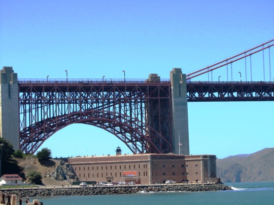
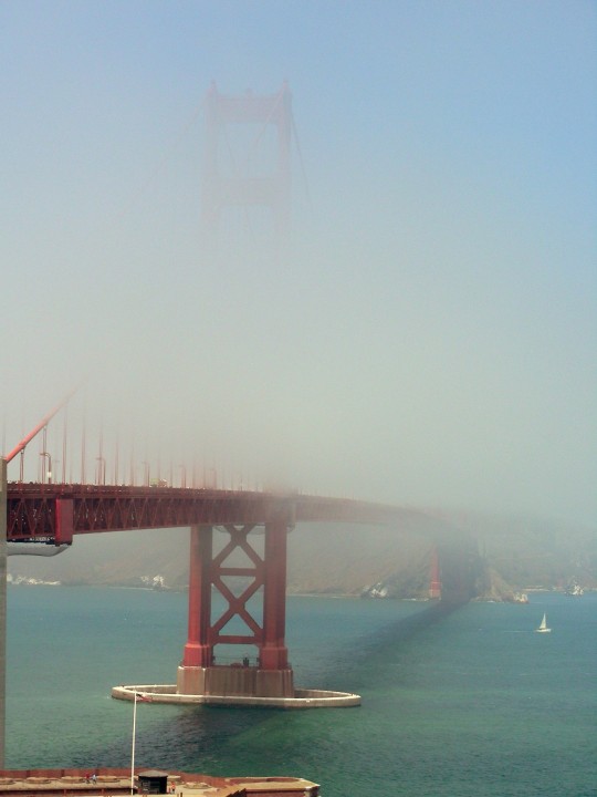
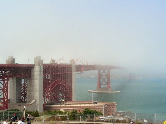
Fort Point National Historic Site was dedicated as a national historic site on April 14, 1971.
#Fort Point National Historic Site#national historic site#14 April 1971#US history#Golden Gate National Recreation Area#Golden Gate Bridge#San Francisco#San Francisco Bay#Pacific Ocean#architecture#cityscape#landmark#USA#West Coast#summer 2016#2008#original photography#summer fog#travel#vacation
12 notes
·
View notes
Text
A Prayer for God’s Blessings on Families, Nations, and the World, Day 74, Cayman Islands
Dear Heavenly Father, Thank you for today. Thank you for what you do for me each and every day and for that which I fail to notice. Thank you for taking care of my family, friends, and acquaintances. I ask that you shield and protect them and guide them in this life. Bring them safely home to you. Let them know that you are there for them. Never let me forget your presence in my life and guide…
#gratitude#Almighty God in Heaven#Cayman Islands#Cayman Turtle Centre#Fort George#Heavenly Father#high cost of living#Pedro St. James National Historic Site#Perpetual Adoration#Queen Elizabeth II Botanic Park#Rum Point#Seven Mile Beach#Stingray City#Wreck of the Ten Sail
0 notes
Note
How do we support Cubans and their resistance to western imperialism
I'm so glad you asked anon! A great way to start is to by actually listening to Cubans and their own stories and news. There are some really good organizations and accounts on Instagram (and many of them have their own publications outside of Instagram, so if you don't have the app, you can still follow what's going on)
Here are the ones I recommend:
@ bellyofthebeastcuba < news outlet that focuses on cuba
@ nationalnetworkoncuba < this is a coalition of many different orgs that are actively working to get the US gov to lift the blockade, etc; they post a lot of actionable things you can do to get involved physically, as well as opportunities for stuff like webinars! here is their website.
@ ratbcuba < this is a british org dedicated to solidarity with cuba
@ caribbeansolidaritynetwork < not strictly cuba oriented, but a network committed to the liberation of all of the caribbean! they also have events like study circles (and you can access their readings online if you can't go in person)
@ ghpartners < this is a nonprofit actively working to get donations in order to send medical supplies to cuba, right now they are working on delivering pacemakers to the island! here is their website.
Other than that, I really, really encourage you to start learning as much as you can on Cuban history and the history of their resistance, as well as their history of working alongside other resistance movements. Cuba worked in solidarity with the Black Panthers, with numerous African countries fighting for their own liberation, with Vietnam, and even more. National Network on Cuba has a really good political education page where you can start that includes a book list and articles list, as well as youtube videos of documentaries. This is a Google drive from NNOC that introduces the concept and history of Guantanamo Bay. There's going to be an Afro-Cuban reading list released on the NNOC site soon, so definitely check back for it.
This is a timeline of the Embargo to help you get introduced to that. This is an article about Afro-Cuban resistance fighters during the revolution. This is an article that discusses the atrocities committed by the Batista regime.
Before you read any of Fidel Castro's work (particularly his famous speech, History Will Absolve Me), read this page first on the history of the attack on the Moncada Fort on July 26, 1953, a year after Batista’s US backed coup d’état. It gives the historical context necessary to read Castro's History Will Absolve Me speech.
This is a PDF of some of Che Guevara's speeches in a collection called Che Guevara Talks to Young People. While the Introduction insists this is not "Che Guevara for beginners" I still think it's a good jumping off point. Here is an interview with Assata Shakur talking about her experiences in Cuba.
I hope this list helps, and of course, it's not exhaustive. I just hope I gave a good enough foundation for anyone who wants to start learning!
#vero.txt#t#asks#resources#< tagging this as well so you guys can find this again#feel free to reblog this ask also!#i feel like the way i answered this makes me sound like im not cuban. i am lol just unforch in the diaspora
475 notes
·
View notes
Text
Singapore’s prosperity has long set it apart from many other former British colonies. There is another difference, too: Singapore has clung to honouring its former colonial ruler — and it wants to keep doing so.
Special accolade has gone to Sir Thomas Stamford Raffles, who is considered to have founded modern Singapore in the early 1800s. For decades, Singapore’s textbooks credited Raffles with transforming the island from a “sleepy fishing village” into a thriving seaport. He has been the central character in a larger official narrative that says imperial Britain had set up Singapore for success as an independent nation.
Dedications to Raffles dot the landscape of Singapore. A business district, schools and dozens of other buildings bear his name. Two 2.5-metre likenesses of the man loom large in downtown Singapore.
But a new statue of Raffles, installed in a park in May, has revived a debate about the legacy of colonialism in Singapore. On one side is the broader establishment, which has held up British colonial rule positively. On the other are those who want a closer inspection of the empire that Raffles represented and the racial inequity he left behind, even as Singapore became wealthy.
This divide has surfaced before, perhaps most prominently a few years ago when Singapore celebrated the bicentennial of Raffles’ arrival on the island. Now, the new statue has set off a fresh debate, with critics pointing out that other countries have for years been taking down monuments to historical figures associated with slavery or imperialism, or both.
“The thing about Raffles is that, unfortunately I think, it has been delivered as a hagiography rather than just history,” said Alfian Sa’at, a playwright who wants to see the Raffles statues destroyed. “It’s so strange — the idea that one would defend colonial practice. It goes against the grain on what’s happening in many parts of the world.”
The new statue of Raffles stands next to one of his friend Nathaniel Wallich, a Danish botanist, at Fort Canning Park. Tan Kee Wee, an economist who pooled $330,000 with his siblings to commission the statues, said he wanted to commemorate the pair’s role in founding Singapore’s first botanic gardens, which were his frequent childhood haunt. He donated the sculptures in his parents’ name to the National Parks Board.
Opponents have also criticised the government for allowing the statue to go up at the park because it was the site of the tomb of precolonial Malay kings. The parks board said it considered historical relevance in the installation of the sculptures.
Questions about the statue have even been raised in Singapore’s parliament. In June, Desmond Lee, the minister for national development, responded to one by saying that Singapore did not glorify its colonial history. At the same time, Lee added, “We need not be afraid of the past.”
The plaque for the Raffles statue explains how Singapore’s first botanic gardens “cultivated plants of economic importance, particularly spices”. That, critics said, was a euphemism for their actual purpose: cash crops for the British Empire.
Tan defended the legacy of British colonialists in Singapore, saying they “didn’t come and kill Singaporeans”.
He added: “Singapore was treated well by the British. So why all this bitterness?”
Far from benign
But colonial Britain was far from benign. For instance, it treated nonwhite residents of Singapore as second-class citizens. Raffles created a town plan for Singapore that segregated people into different racial enclaves. And he did not interact with the locals, said Kwa Chong Guan, a historian.
“He was very much a corporate company man, just concerned with what he assumed to be the English East India Co’s interests,” Kwa said.
Raffles landed in Singapore in 1819 as Britain was looking to compete with the Dutch in the Malacca Strait, a crucial waterway to China. At the time, Singapore was under the sway of the kingdom of Johor in present-day Malaysia. Raffles exploited a succession dispute in Johor to secure a treaty that allowed the East India Company to set up a trading post in Singapore.
Within a handful of years, Singapore was officially a British territory. Convict labour, largely from the Indian subcontinent, was crucial to its economic development. So, too, were Chinese immigrants, which included wealthy traders and poor labourers.
Singapore achieved self-governance in 1959, then briefly joined Malaysia before becoming an independent republic in 1965. It has since built one of the world’s most open economies and among its busiest ports, as well as a bustling regional financial hub.
In recent years, the government has acknowledged, in small ways, the need to expand the narrative of Singapore’s founding beyond Raffles. Its textbooks now reflect that the island was a thriving centre of regional trade for hundreds of years before Raffles arrived.
In 2019, officials cast the commemoration of Raffles’ arrival as also a celebration of others who built Singapore. A Raffles statue was painted over as if to disappear into the backdrop. Placed next to it, though only for the duration of the event, were four other sculptures of early settlers, including that of Sang Nila Utama, a Malay prince who founded what was called Singapura in 1299.
To some historians and intellectuals, such gestures are merely symbolic and ignore the reckoning Singapore needs to have with its colonial past. British rule introduced racist stereotypes about nonwhites, such as that of the “lazy” Malay, an Indigenous group in Singapore, that has had a lasting effect on public attitudes. Colonialism led to racial divisions that, in many ways, persist to this day in the city-state that is now dominated by ethnic Chinese.
“If you only focus on one man and the so-called benevolent aspect of colonialism, and you don’t try to associate or think about the negative part too much, isn’t that a kind of blindness, or deliberate amnesia?” said Sai Siew Min, an independent historian. (Story continues below)
Role of race
Race relations played a role in Raffles’ ascension in Singaporean lore. Soon after Singapore became independent, the governing People’s Action Party — which remains in power decades later — decided to officially declare Raffles the founder of Singapore. Years later, S Rajaratnam, who was then the foreign minister, said that anointing a Malay, Chinese or Indian as its founder would have been fraught.
“So we put up an Englishman — a neutral, so there will be no dissension,” Rajaratnam said.
The decision was also meant to indicate that Singapore remained open to the West and free markets.
In a 1983 speech, Rajaratnam acknowledged that Raffles’ attitude toward the “nonwhite races was that without British overlordship the natives would not amount to much”.
Critics of the Raffles statues also argue that his legacy should reflect his time on the island of Java. Although Raffles outlawed slavery in Singapore, he allowed trading of slaves in Java, including children as young as 13, according to Tim Hannigan, who wrote a book about Raffles.
The new statues of Raffles and Wallich were created by Andrew Lacey, a British artist. The sculptures evoke the two men as apparitions — symbolism that Lacey said represented the world’s evolution away from the West.
Lacey said he had “wrangled” with the public reaction toward his sculptures and he had no qualms if Singaporeans wanted to take them down, destroy them or replace their heads with the Malay gardeners who were instrumental in creating the botanic gardens.
“I was cognisant of the complexities of making any dead white male,” he said of Raffles. “I wasn’t cognisant of the degree of complexity around him.”
16 notes
·
View notes
Photo

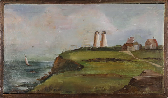
Lighthouse Keeper chest ?, 19th century
Painted with view of Gurnet Twin Lighthouses. Plymouth Light Station, also known as Gurnet Light, was first established on a high bluff at the end of Gurnet Point in 1768. Plymouth served as one of the major ports of colonial America. Increased shipping traffic necessitated a navigational aid to guide mariners in and out of Plymouth Harbor and further promote trade. The original structure resembled a house with a lantern room at each end of the roof. After a fire destroyed the first light station in 1801, a new pair of wooden towers was constructed by 1803.
In 1842 the crumbling towers were replaced with two white octagonal pyramidal towers. The north light was 110 feet above sea level, and the south tower 102 feet. However, the lights were too close together and often were seen as a merged single beam of light. 1871 a fourth-order fresnel lens was installed, greatly increasing the strength of the lights. And in 1914 the Cape Cod Canal opened, giving new importance to the Gurnet as a navigational aid. The Bureau of Lighthouses discontinued one of the twin lights in 1924 as it phased out multiple lights. The remaining light still stands.
On March 8, 1977, the Plymouth Light Station was officially listed on the National Register of Historic Places. In 1998 the Coast Guard moved the lighthouse back from the eroding 45-foot cliff. It was standing only 50 feet from the edge when it was placed on rollers and moved by tracks 140 feet from its previous site. It now sits on the property of Fort Andrew at Gurnet Point. And in 1999 the Coast Guard gave Project Gurnet & Bug Lights, Inc. the first of many 5-year licenses allowing us to restore, preserve, and maintain Gurnet Light.
#naval artifacts#chest#lighthouse keeper chest ?#gurnet twin lighthouses#19th century#lighthouse history
110 notes
·
View notes
Note
What's the itinerary? 👀
Hi, Anon! Happy to share.
My dream American Revolution trip itinerary, just including my must-sees, and a rough idea of transportation (still working on food stops and slipping in other points of interest):
Day 1:
Early morning flight to Boston, MA
Stay in Boston for 3 nights, 4 days
Rental car for Day 2 and 3
Boston Massacre Site
Boston Tea Party Ships & Museum
Bunker Hill Museum and Monument
Old North Church & Historic Site
Day 2:
Paul Revere House
Lexington Battle Green Tour, Lexington MA
Drive from Boston
Old North Bridge, Concord MA
Drive from Lexington
Day 3:
Adams National Historic Park, Quincy MA
Drive from Boston
General Nathaniel Greene Homestead, Coventry RI
Drive from Adams NHP
Day 4:
Early morning train/bus to Albany, NY
Stay in Albany 2 nights, 3 days
Rental car for Day 4 and 5
Saratoga National Historical Park, Stillwater NY
Drive from Albany
Fort Ticonderoga, Ticonderoga NY
Drive from Saratoga NHP
Day 5:
Schuyler Mansion tour
Washington’s Headquarters State Historic Site, Newbrugh NY
Drive from Albany
John Jay Homestead, Katonah NY
Drive from Washington Headquarters Newbrugh
Day 6:
Early morning train from Albany to New York City, NY
Stay in New York City for 4 nights, 5 days
Hamilton Grange National Memorial
Morris-Jumel Mansion
Day 7:
City Hall Park
Federal Hall
Fraunces Tavern Museum
Trinity Church & Cemetary
Day 8:
Museum of the City of New York
The Metropolitan Museum of Art
Day 9:
Van Cortlandt House Museum
Central Park
New York Historical Society Museum & Library
Weehawken Dueling Grounds/Hamilton Park, Weehawken, NJ
Take ferry to and from
Day 10:
Train/bus to Princeton, NJ
Stay in Princeton 2 nights, 3 days
Rental car for Day 11
Princeton Battlefield State Park
Day 11:
Monmouth Battlefield State Park, Manalapan, NJ
Drive from Princeton
Morristown National Historical Park, Morristown NJ (Includes: Ford Mansion/Washington’s Headquarters, Schuyler-Hamilton House, Jockey Hollow)
Drive from Monmouth Battlefield Park
Day 12:
Early train/bus to Trenton, NJ
Old Barracks Museum
Washington Crossing Park, Washington Crossing, PA
Train/bus from Trenton
Train/Bus from Washington Crossing to Philadelphia PA
Stay in Philadelphia 3 nights, 4 days
Rental car for Day 15 and 16
Day 13:
Independence Hall
Liberty Bell Center
First Bank of the United States
Carpenter’s Hall
Day 14:
Museum of the American Revolution
Elfreth’s Alley Museum
Day 15:
Valley Forge National Historical Park
Drive from Philadelphia
Moland House (Washington Headquarters), Warwick Township PA
Drive from Valley Forge NHP
Peter Wentz Farmstead (Washington Headquarters), Lansdale PA
Drive from Moland House
Day 16:
Cliveden of the National Trust (Chew House)
Drive from Philadelphia
Brandywine Battlefield (park), Chadds Ford PA
Drive from Cliveden
Afternoon or evening train from Philadelphia to Alexandria, VA
Stay in Alexandria for 2 nights, 3 days
Rental car for Day 18
Day 17:
George Washington’s Mount Vernon
Train/bus from Alexandria, VA
National Archives Museum, Washington DC
Train/bus from Alexandria, VA
Day 18:
James Madison’s Montpelier, Montpelier Station, VA
Drive from Alexandria, VA
Evening train from Alexandria to Williamsburg, VA
Stay in Williamsburg 2 nights
Day 19:
Colonial Williamsburg
Day 20:
Yorktown Battlefield
American Revolution Museum at Yorktown
Train/bus/taxi from Williamsburg
Day 21:
Fly from Williamsburg to Charleston, SC
Stay in Charleston for 4 nights, 5 days
Rental car for Days 22-24
South Carolina Historical Society Museum
Day 22:
Savannah History Museum, Savannah GA
Battlefield Park Heritage Center, Savannah GA
Drive from Charleston
Day 23:
Cowpens National Battlefield, Cowpens SC
Drive from Charleston
Eutaw Springs Battlefield Park, Eutawville SC
Drive from Cowpens
Day 24:
Magnolia Plantation and Gardens
Mempkin Abbey (site of Laurens family graves)
Day 25:
Fly home from Charleston SC
#my real challenge is finding someone to go with me#fun part about being visually impaired is you can’t legally drive#amrev#trips#road trip#the american revolution#american revolutionary war#new england#dream travel#traveling#18th century history
10 notes
·
View notes
Text
https://ictnews.org/news/biden-designates-avi-kwa-ame-a-national-monument
Joe Biden designates Avi Kwa Ame a national monument
President Joe Biden announced on Tuesday Avi Kwa Ame as a national monument in Nevada, following up on a promise he made in late 2022.
Biden also declared a national monument in Texas and the creation of a marine sanctuary in U.S. waters near the Pacific Remote Islands southwest of Hawai'i.
Biden spoke at the White House Conservation in Action Summit at the Interior Department with Fort Mojave Indian Tribal Chairman Timothy Williams commending him during his introduction.
“Under his leadership we have a seat at the table and we are seeing an unprecedented era and opportunity for our tribal communities,” Williams said. “And we are all grateful to the president for taking historic action to combat the climate crisis and conserve and restore our nation’s land and waters.”
Williams was among the proponents to make Avi Kwa Ame, also known as Spirit Mountain, a national monument. It’s considered sacred to the Mojave people and for the nine other Yuman-speaking tribes along the Colorado River, as well as the Hopi and Chemehuevi Paiute tribes, Williams said.
The site in southern Nevada spans more than 500,000 acres near the Arizona and California state lines. It’s home to bighorn sheep, desert tortoises and a large concentration of Joshua trees, some of which are more than 900 years old. It’s also listed on the National Register of Historic Places.
It took more than three months for Biden to make the announcement.
“It’s a place of reverence, it’s a place of spirituality, it’s a place of healing and now it will be recognized for its significance it holds and be preserved forever,” Biden said. “I look forward to visiting it myself.”
He thanked Williams and the legislative leaders who advocated for Avi Kwa Ame including Nevada Rep. Dina Titus, Democrat, who sponsored a bill to protect the rugged region near the Mojave National Preserve from development, including solar farms and a proposed wind farm.
“To the native people who point to Avi Kwa Ame as their spiritual birthplace, and every Nevadan who knows the value of our cherished public lands: Today is for you,″ Titus tweeted.
The Honor Avi Kwa Ame coalition, which includes tribes, local residents, state lawmakers and conservation groups, said its members were "overjoyed" to learn the site will be a new national monument.
"Together, we will honor Avi Kwa Ame today — from its rich Indigenous history, to its vast and diverse plant and wildlife, to the outdoor recreation opportunities created for local cities and towns in southern Nevada by a new gorgeous monument right in their backyard," the group said.
Interior Secretary Deb Haaland released a press release praising the announcement.
“I am grateful to President Biden for taking this important step in recognition of the decades of advocacy from tribes and the scientific community, who are eager to protect the objects within its boundaries,” Haaland stated.“Together with tribal leaders, outdoor enthusiasts, local elected officials, and other stakeholders, we will manage this new monument for the benefit of current and future generations.”
In Texas, Biden plans to create the Castner Range National Monument in El Paso. It’s the ancestral homeland of the Comanche and Apache people, and its cultural ecology is considered sacred to several Indigenous communities.
The designation will protect the cultural, scientific and historic objects found within the monument's boundaries, honor U.S. veterans, service members and tribal nations, and expand access to outdoor recreation on public lands, the White House said.
Located on Fort Bliss, Castner Range served as a training and testing site for the U.S. Army during World War II, the Korean War and the Vietnam War. The Army ceased training at the site and closed Castner Range in 1966.
The Castner Range monument "will preserve fragile lands already surrounded on three sides by development,'' help ensure access to clean water and protect rare and endangered species, said Rep. Veronica Escobar, Democrat-Texas.
“The people of El Paso have fought to protect this for 50 years. Their work has finally paid off,” Biden said.
Biden designated his first national monument, in Colorado, last year. In 2021, he restored the boundaries for Bears Ears National Monument in Utah after they were significantly narrowed by President Donald Trump, a Republican.
In the Pacific, Biden will direct the Commerce Department to consider initiating a new national marine sanctuary designation within 30 days to protect all U.S. waters around the Pacific Remote Islands. If completed, the 777,000 square miles, southwest of Hawaii, will help ensure the U.S. reaches Biden's goal to conserve at least 30 percent of ocean waters under U.S. jurisdiction by 2030, the White House said.
Among Hawaiian state leaders, Biden thanked Native Hawaiian leaders who “worked tirelessly to protect our oceans. I want to thank you. I genuinely mean it, it wouldn't have happened without you.”
Biden also announced a series of steps to conserve, restore and expand access to public lands and waters across the country, the White House said.
The proposals seek to modernize management of America's public lands, harness the power of the ocean to help fight climate change, and better conserve wildlife corridors. Biden also will announce new spending to improve access to outdoor recreation, promote tribal conservation and reduce wildfire risk.
Bidden added he’s committed to working with tribal leaders and legislative leaders on bringing “healthy and abundant” salmon run back to the Colorado River system.
“There’s nothing beyond our capacity if we work together,” Biden said.
66 notes
·
View notes
Text

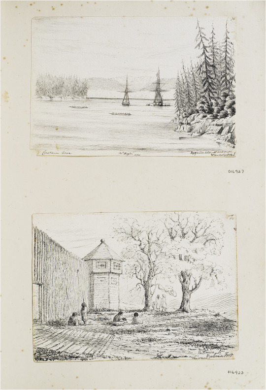


John Linton Palmer, Views near Fort Victoria, June–July 1851, pen and ink, From Chile to the Arctic Album, F030/4 © RGS-IBG.
First plate, top: Esquimalt harbour, with Constance Cove, and Mt Angeles in the distance.
First plate, below: ‘Entrance to Victoria Fort’.
Second plate, above: ‘Fort Victoria, Vancouver I.’.
Second plate, below: ‘From landing place at Victoria Fort’ [original caption].
Third plate: Sketches of people and artefacts, Vancouver Island, June–July 1851. Fourth plate: Tomb of King Freezy’s brother at the entrance of Victoria Inlet, B. Columbia, 1851′.
"In considering such archival images as traces of encounter, contemporary historians would of course seek to adduce more evidence about the meanings of such events for the participants, in this case both British and Hawaiian, situating these events in their time and place. From this perspective, the rituals of diplomacy, the expectations of the various parties, the knowing and unknowing ways in which these events were described, would all need to be investigated. The same is true of the many other examples of the art of encounter in Linton Palmer’s albums. From an art historical perspective, such imagery would also need to be carefully contextualized with reference to matters of style, genre and perspective. In many cases, as I have argued, the influence of the naval tradition of maritime view-making is clear. However, there is another way of seeing these visual archives, especially when encountered from a heritage perspective, in which the informational content – the documentary detail – may matter even more than the point of view.
In order to substantiate this final point, we should return to Linton Palmer’s Fort Victoria sketches. Fleeting views they may have been, but in their attention to detail – whether the rendering of the hair and adornments of the people he encountered, or the material evidence of Indigenous presence in the landscape – such pencil sketches by naval visitors sometimes record what other contemporary documents do not, and in ways that can be located precisely in space and time. The matt lodges around the Fort, the cedar plank houses across the harbour, a fishing station in the distance: all these features signal an active Indigenous presence at a particular moment preceding a disastrous era in the history of the Indigenous people of what became British Columbia. Since they were first made available to First Nations historians following their exhibition in a 2009 RGS-IBG exhibition (Hidden Histories of Exploration), Linton Palmer’s images have entered the visual archive of Indigenous history and made more widely available in digital form. In particular, they have been incorporated into understandings of local settlement history by Grant Keddie, a curator at the Royal British Columbia Museum in Victoria. As Keddie’s work indicates, there is an ‘archaeological’ way of reading such documents, cross-referencing with other sources of evidence about the precise geography and chronology of landscape change. As is clear from the contemporary significance of the Indigenous sites sketched by Linton Palmer, such work is far from merely of academic interest. In 2001, 150 years after the brief visit of HMS Portland to Fort Victoria, a claim was filed in Canadian courts asserting that the land on which the Parliament of British Columbia was built (near the original Fort) had originally been occupied by or promised to First Nations peoples. After a long and contested legal process, the Ministry of Aboriginal Affairs and Reconciliation eventually reached an out of court settlement with the representatives of the Esquimalt and Songhees nations, which has been valued at $31.5 million dollars. In this context, mapping the precise geography of Indigenous settlement in space and time mattered a great deal: in fact it truly was the multi-million dollar question. And in the process, as researchers and consultants pored over long forgotten maps and drawings not unlike Linton Palmer’s sketches, the visual archive of travel acquired a new value." - Felix Driver, "Material memories of travel: the albums of a Victorian naval surgeon." Journal of Historical Geography 69 (2020): 53-54
#linton palmer#historical geography#art album#royal navy#vancouver island#victoria#settler colonialism in canada#settler colonialism#indigenous land claims#indigenous history#british empire#canadian history#academic quote#first nations#indigenous people#british columbia history
6 notes
·
View notes
Text
Port Jervis, New York - A Historic Canal and Railroad Transport Hub

With roots as a pre-automobile transportation hub, Port Jervis, New York, is a historic burgh with a history of colonial settlement extending to the 1690s. Northeast of New York City, it’s situated amidst the fertile valleys of the Delaware and Neversink River systems. The valleys mark the boundary between the Appalachian Plateau and Shawangunk Mountains, and hundreds of miles of state and nationally-managed recreational lands surround it.
Initially known as Carpenter’s Point, Port Jervis was a landing point for timber raftsmen who plied the upper Delaware River. It was also a stop on the Old Mine Road, the country’s first 100-mile road (now United States Route 209), which took travelers south from Kingston.
Carpenter’s Point was incorporated into Deerpark in 1798. The locale was named Port Jervis in 1827, and it officially became a port of the Delaware River and Hudson Canal in 1828. As a repair point and boat basin, it formed an essential station on a 171-mile-long transportation network that brought anthracite coal from Pennsylvania’s northeastern mountains to New England and New York City. The name was in honor of the Hudson Canal’s chief engineer, John B. Jervis, from Rome, New York.
In 1847, Port Jervis became a hub for railroad operations and grew to house a main engine terminal facility while serving as the Delaware Division of the Erie Railroad’s headquarters. This property included the railroad’s primary maintenance and yard facilities.
Port Jervis officially became a village in 1853 and ultimately incorporated as a city in 1907. In the late 19th century, several glass factories began business, and an influx of employees producing glassware, silk, gloves, shorts, mittens, and saws moved in. The railroad yards and light manufacturing shops were a major part of the local economy through the 1960s.
Today, tourism is the mainstay of Port Jervis, with historic Front Street featuring eateries, a bookshop, antique shops, and other small businesses. The well-marked Delaware River Heritage Trail provides a walking tour of various gardens, historical structures, and an exceptional view of the Delaware River.
Among the well-preserved sites worth exploring is Fort Decker, a stone house on West Main Street that was initially constructed in 1760 and burnt by Joseph Brant alongside Native American allies in a 1779 raid during the Revolutionary War. Serving as the Minisink Valley Historical Society museum, Martinus Decker rebuilt the house in 1793 and used it as a tavern and hotel during the years of the Delaware and Hudson Canal construction. Indeed, John B. Jervis stayed at the location while engineering the canal.
Another historic remnant is the Port Jervis turntable, which comprises a circular area with a 115-foot diameter and a bridge. Able to carry a weight of more than 440 tons or a locomotive loaded with coal and water, the turntable is the largest that still operates nationwide.
Befitting its status as a scenic tourist destination, Port Jervis offers several popular events each year, including the Fall Foliage Festival, for which volunteers place 50 corn stalks on light poles decorating Pike and Front Streets. There are also popular holiday events such as the Downtown Spooktacular and the Chriskindlmarkt, with the latter featuring horse and carriage rides and traditional juggling as entertainment.
3 notes
·
View notes
Text
Historic Gotham: Part One
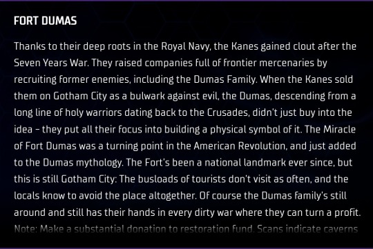
Fort Dumas: Thanks to their deep roots in the Royal Navy, the Kanes gained clout after the Seven Years War. They raised companies full of frontier mercenaries by recruiting former enemies, including the Dumas Family. When the Kanes sold them on Gotham City as a bulwark against evil, the Dumas, descending from a long line of holy warriors dating back to the Crusades, didn't just buy into the idea - they put all their focus into building a physical symbol of it. The Miracle of Fort Dumas was a turning point in the American Revolution, and just added to the Dumas mythology. The Fort's been a national landmark ever since, but this is still Gotham City: The busloads of tourists don't visit as often, and the locals know to avoid the place altogether. Of course the Dumas family's still around and still has their hands in every dirty war where they can turn a profit. Note: Make a substantial donation to restoration fund. Scans indicate caverns under cliff; could reinforce for water-borne operations?
I remember when Bruce was investigating the possibility of having multiple Batcaves around the city. Shame he never went through with it. - J. T.

Gotham City Cathedral: The Gotham Cathedral is the largest church in Gotham City and was the city's first supermassive structure. It was designed by Cyrus Pinkney in the 1840s and took almost thirty years to finish. It was officially completed in 1877. Pinkney was a very religious man and imbued the cathedral with designs that would "cast away evil spirits", like the gargoyles located around the church. He's also responsible for the design and construction of the mansion that later became Arkham Asylum. The Gotham Cathedral became such a renowned landmark that its style - dubbed the "New Gotham Style" - was recreated by various architects for other buildings across the city. This is also where my parents' funeral took place before they were brought to the Wayne family crypt at the Gotham City cemetery. I haven't gone inside since.
Gotham City Fire Department: The Gotham City Fire Department was established in the 1800s and was then known as the Gotham Town Fire Brigade. It was privately run and was composed of a small group of volunteers who patrolled the streets for signs of fires. At the onset of the Industrial Revolution, many factories opened their doors in Gotham, but due to a lack of volunteers and resources to protect the new warehouses, the fire brigade was turned into a government-run institution. This allowed the newly formed fire department to widen their efforts to the rest of Gotham. The GCFD puts out thousands of fires every year and are almost always accompanied by GCPD officers when responding to emergencies, as they are ill-equipped to deal with the city's criminal gangs, who are responsible for over 70% of all fires in Gotham.
City Hall: The original City Hall occupied Gotham Town's former Courthouse and was the site of the signing of the city charter in 1836. A statue was built in the adjoining plaza to honor Bartholomew Wycliffe, Gotham City's first mayor. The new building features a modern bas-relief wall design at street level, which portrays key moments from Gotham's foundation. As Batman, I tend to stay far away from City Hall, but as Bruce Wayne I've had to visit many times to acquire permits for various projects. City Hall has been the site of multiple riots through the years, like the one of 1840 that eventually led to the creation of the GCPD. This, in addition to the arrival of meta criminals, has forced the mayor to increase the building's security. It has been equipped with reinforced doors and windows as well as a safe room in the basement, where the mayor can retreat in case of emergency.
3 notes
·
View notes
Text
a personal reflection on decolonization
riel s. | 2022
Tansii kiiya (hello, how are you?) my name is riel starr and I am a Red River Michif artist and academic. my history on his land begins thousands of years ago among the peoples of the great plains, and my written history begins in the late 1600s with my first French ancestors and their unnamed first nations wives. my first First Nations ancestor is an unnamed woman referred to in my grandmother’s family tree as “Cree Woman”. I am Red River Métis on my mother’s side. Our historic Métis family names are Berthelet, Caron, St. Germaine, Dazé, Larivière and Dubois, and we come from the communities of Point à Grouette (now called St. Agathe), St. Norbert, and St. Vital (now modern-day Winnipeg) as well as the historic Batoche, Saskatchewan. My Berthelet ancestors were notable community leaders in Pointe à Grouette and my Caron ancestors including my fifth great uncle jean caron sr. fought in the North West resistance of 1885 at the battle of Duck Lake when he was fifty-two years old. Jean Caron Sr’s house is now a historic site in Batoche. As for myself my mother is a Métis educator and academic and my father is a settler archaeologist-turned-locksmith. I introduce myself in this way, the traditional way of Métis writers to contextualize my family, my knowledge and experiences, as well as my place on this land.
Natually, my native mother and my settler archaeologist father never married and split before I was old enough to form any memories. Museums and history have always been a fascination to me; the Royal Terrell Museum in Drumheller, which I dubbed “the dead dinosaur museum” and the Royal Alberta Museum which I called “the dead mouse museum” after my favourite display. The display was a larger-than-life diorama of a mouse, it’s intestines showing, the organisms that helped decompose the corpse were also displayed, massive daddy long legs, gigantic ants, worms thicker than my arm. The RAM is an interesting place. A few years ago, it was moved into a new building downtown and I could no longer spend hours finding fossils in the limestone exterior of the original museum. The place had changed drastically. As I reminisce on what I loved about the RAM I realize that all the things I disliked were their representations of Indigenous people; the uncanny wax figures with placid skin that did not resemble a single Native person’s skin that I had met. and the artwork they portrayed as artifacts. What makes a beaded bag so different from a Van Dyck if they’re the same age? And honoured the same amount by the people who made them?
Another place of importance growing up was Fort Edmonton Park. Like Heritage Park, Fort Edmonton has costumed interpreters, who teach visitors history as if the interpreters were of that time. In the summer of 2017, my lifelong dream came true, and I became a volunteer costumed interpreter with my mentor Sheldon Stockdale, another Métis person, and we were able to teach our history in the way we felt was right, something deeply important to the Métis people. An experience we had that stands out vividly is working on Fort Edmonton’s 1920 Street, and educating visitors on the history of pemmican, a sort of ancient protein bar made from berries, dried meat, and animal fat. Pemmican was a staple of survival for the Métis, and we were asking visitors to help us in redesigning the packaging for the bar. The historic package had a representation of an Indigenous person on it, a caricature of a race. We asked visitors if turning Indigenous people into mascots should be accepted, and sadly many people didn’t see the problem. Sheldon and I borderline argued with a man who seemed to see no problem in reducing us, the people speaking to him, to caricatures. In a similar vein, someone once gave me Chicago Blackhawk’s stickers when i was six, and not knowing a thing about hockey I asked my mother who the stickers were of. I’m guessing my mother did not want to explain the history of colonization and caricatures of Indigenous people, so she dismissed my question by telling me that the man in the tacky illustration was my ancestor.
Decolonizing art history seems like an impossible task, and perhaps it is. You cannot separate someone like Emily Carr from art history in Canada, however you can change the way you teach her work. Perhaps decolonizing art history means recognizing the ways in which “art history” as a field of study is deeply Euro-centric, and how the way of teaching this history is the same. I took my first semester at AUArts in the fall of 2020 after transferring from MacEwan after completing a two-year diploma at MacEwan University. I had a sculpture class a media arts class an art history class. The more I consider how to decolonize our history the more I understand that it is not the history that can be decolonized, it is the way we are teaching said history. It is the way that so much of our education is taught to us through a colonial lens, rather than a multifaceted history with a multitude of perspectives and peoples contributing until an entire picture is formed.
In the fall of 2020 in my media arts class my professor Kurtis Lesick was discussing an artist, a black artist who had him and others participate in a performance in which in that space the black artist allowed the participants to say the N-word. Rather than describing the piece in the way I just did removing the slur, Kurtis Lesick made the conscious decision to say the N- word twice. A person I had once thought to be an ally of mine, who knew the language of decolonization. Earlier this year a classmate in this class who was also in my sculpture class in the winter of 2022 told me that ‘knowing me has made her a better person’, this woman does not know me, and I do not know her, but I knew her in that moment. I knew that she wanted me to absolve her of her settler guilt. White settlers love referencing Tuck and Yang’s Decolonization Is Not a Metaphor but sometimes I wonder if they truly understand that it is simply not enough to know the language of decolonization, that you must be actively anti-colonial in a field that is built on colonization.
I spent a lot of time at Fort Calgary this semester for my FINA class, critiquing their exhibitions wondering how they can be improved if they can be improved, and I learned that given their budget that it is not possible. Fort Calgary, like other institutions cannot afford to replace their current exhibits and entirely redesign the way they teach history. What they can do is acknowledge the missing pieces, they can acknowledge the gaps they can acknowledge the fact that there’s more than one canon of history. Sometimes I wonder if the mosaic of history is too complex to decolonize; knowing that we will never return to a world like the one that existed pre-colonization. I think about my one classmate who tokenizes me, who knows how to use decolonial language to appear one way, but who never puts those concepts into practice. I think about the settlers who think that decolonization is re-colonizing the Americas but with “the Indians” in charge this time.
I now understand that decolonizing art history cannot happen without first decolonizing institutions. I have learned that we cannot forget that we once taught art history in an i way we cannot forget the way colonization has infiltrated every aspect of the education system down to the teaching styles of each professor. if we forget how colonial art history is in the first place, we will forget why we need to decolonize. Considering the hand that art history is hard in colonization around the world, I consider about the way southeast Asian women’s bodies are talked about in my textbooks versus European odalisque paintings. Brown people’s bodies were inherently sexualized and seen as dirty, while white people’s bodies were adored and deemed Classical.
Maybe colonization is another movement in the worldwide canon of art history. Another period in the bar graph of history- as google images seems to see art history. Perhaps Emily Carr and Paul Gauguin are the faces of this genre. Just as colonization cannot be forgotten among its victims, it cannot be forgotten by its perpetrators, who still believe they are a superior culture and race. Genres of literature such as post-colonial writing from India and Sri Lanka may suggest, there was a period of colonial art and literature, perhaps it is ongoing, possibly dying out, maybe here to stay. There will always be an antithesis, an attempt to view art and art history from a different perspective, and that is how we can decolonize art history.
#i posted this on my artist page but i only use it for professional reasons and i don't wanna share it here unless you're a mutual lolol#riel text#my writing#academia#institutional critique#art writing#decolonization#indigenous#métis#michif#indigenous art#first nations art#FNMI art#art#alberta#calgary#post colonialism#colonialism#canada#land back
7 notes
·
View notes
Text


The Golden Gate National Recreation Area was created on October 27, 1972.
#Golden Gate National Recreation Area#created#27 October 1972#US history#anniversary#Alcatraz Federal Penitentiary#San Francisco#California#USA#United States Penitentiary Alcatraz Island#Presidio of San Francisco#Crissy Field#cityscape#summer 2017#Golden Gate Bridge#Fort Point National Historic Site#Mori Point#Pacific Ocean#Pacifica#travel#San Francisco Bay#vacation#architecture#Sequoia sempervirens#tree#landscape#Pacifica Beach View Park#original photography#tourist attraction#landmark
1 note
·
View note
Text
What Black History Has To Do With The Cretaceous Period
Known Today As The “Black Belt,” The Southeastern United States Was Once Covered by an Ancient Sea—One That Continues To Shape Modern History.
— By James Edward Mills | February 26, 2025

A man with warm brown skin and a short tapped hair gazes upward and head tilted with one hand placed on top of the other. He is wearing a uniform with an emblem that is not fully visible. Photograph By Kris Graves
Frank Toland is a park ranger for Tuskegee Airmen National Historic Site at Moton Field in Alabama. It is here where the Tuskegee Airmen started training for aerial combat in 1941 during World War II. Nearby is a site historians say is "where the South as we know it today begins." Photograph By Kris Graves
As a public historian and National Geographic Explorer, I’m constantly on the trail of interesting stories that connect a series of events dating back several centuries but continue to resonate into modern times. On a recent road trip through the American South, my partner, National Geographic photographer Kris Graves, and I drove through Tuskegee, Alabama, where we found a connection to a time long before human beings walked the Earth.
It’s a story of how the geology of the Cretaceous Period, between 70 and 100 Million years ago, emphatically changed the course of American history.
Where The South As We Know It Began
About 80 miles from Tuskegee, along highway 431, we approached Horseshoe Bend National Military Park. Not to be confused the "Horseshoe Bend" segment of the Colorado River in Arizona, this site, established in 1959, is the site of the Battle of Horseshoe Bend. My first assumption was that this was a battlefield from the Civil War. But as it turns out, I was off by more than 50 years.

A Map that Shows Fortifications and Troop Positions During War with Native Americans in 1814. Map Via Library Of Congress, Geography And Map Division
It was here in 1814, during the War of 1812, that General Andrew Jackson came to national prominence by defeating the Muscogee Indians. The Native People who had settled on the land surrounding the Tallapoosa River watershed, offered the last resistance against the expansion of the newly founded United States of America into this southeastern corner of the continent.
After the Battle of Horseshoe Bend, the Treaty of Fort Jackson ceded more than 23 million acres of Native land to the U.S. Government and opened the Mississippi Territory for pioneer settlement. This area ultimately created the states we now call Alabama and Georgia. It has been suggested by historians that this is where the South as we know it today begins.
This was a geographic flash point of American history. After the Battle of Horseshoe Bend, the Muscogee Indians were summarily displaced and sent to reservations in Oklahoma and other points on the map west of the Mississippi River. From 1816 to 1840 native people were forced to travel west along a path known commonly as the Trail of Tears.
Once removed, Native People were replaced with white settlers who quickly discovered the rich soil in this location was perfect for the cultivation of cash crops such as indigo, corn, rice and cotton. In letters to his wife, Rachel, Andrew Jackson writes about the soil of Alabama: "The lands through which we passed are some of the richest this country can boast—well watered and abundantly fertile, they will no doubt soon be settled by a happy and prosperous people."


Left: A vintage, open-cockpit biplane called the PT-13D Stearman Kaydet was used to train the first generation of Black American combat pilots at the Tuskegee Institute. Photograph By Kris Graves. Right: A group of soldiers lined up with a plane in the background Tuskegee airmen training in 1942. Photograph By Library of Congress, Prints & Photographs Division, Farm Security Administration/Office Of War Information Black-And-White Negatives
Ancient Organism Laid The Foundation For The South’s Fertile Land
There’s a deep reason for the richness of the soil they remarked on there.
Over 70 million years ago, during the late Cretaceous period, the southeastern U.S. was a warm, subtropical region covered by a vast shallow sea known as the Western Interior Seaway. Much of the area was a coastal plain with swamps, rivers, and dense vegetation. Dinosaurs like hadrosaurs, tyrannosaurs, and ceratopsians roamed the land, while giant marine reptiles such as mosasaurs and plesiosaurs dominated the waters. The climate was humid, and the region was rich in diverse plant and animal life, resembling modern coastal wetlands and estuaries.
Over millions of years, marine organisms like plankton and shellfish accumulated on the seafloor, forming thick deposits of calcium-rich limestone. When the sea receded, these limestone deposits weathered into fertile, alkaline soils that became ideal for agriculture. This rich, dark soil gave the Black Belt—an area that stretches from east-central Mississippi through central Alabama and into western Georgia--its name and later made the region a prime area for cotton farming in the 19th century.

The National Memorial For Peace and Justice in Montgomery Alabama is dedicated to Black Americans who were terrorized by lynching throughout the late 19th and 20th Centuries. A series of pillars hang in the display to represent the many counties across the U.S. where incidents of public execution were perpetrated. The name of each victim is inscribed on the pillar of the county in which they were killed. Photograph By Kris Graves
The Ancient History Still Leaves An Imprint On The Present
The geological landscape of the Black Belt created the physical environment where Black Americans would be subjected to the cruel exploitation of their labor. First through chattel slavery, then by a system of inequitable sharecropping and convict leasing programs, people of African descent would be made to work the soil of this region so rich in fossil decay.
But labor-intensive commodities like cotton require a great many hands to reap their benefits. The necessity for a dedicated workforce provided the economic incentive to expand and intensify the institution of slavery. In this place, at this time, through the Civil War, we see an ever-increasing concentration of enslaved Black Americans. And, their descendants still live there today.
In the 21st Century, the descendants of the formerly enslaved make up large segments of the population in these areas. The Black Belt's geological, historical and demographic legacy, combined with ongoing advocacy efforts, has made it a critical region for Black voter registration and political empowerment throughout the United States.

Coretta Scott King, John Lewis and a crowd of 5,000, march across the Edmund Pettus Bridge from Selma, Alabama Saturday, March 8, 1975. The historic march takes place on land that was made fertile by an ancient sea. Photograph By Associated Press
The geographic footprint of the Black Belt directly overlays the route of the U.S. Civil Rights Trail. Defined by a series of historic parks and monuments managed by the National Park Service, this path traces a timeline through critical moments in Black American history. From the murder of Emmitt Till near Greenwood, Mississippi, to where Rosa Parks refused to give up her seat on a bus in Montgomery, to the site of the 16th Street Baptist Church Bombing in Birmingham, to where John Lewis led the march for voting rights in Selma across the Edmund Pettus Bridge, to the training base of the Tuskegee Airmen, each of these locations and corresponding events can be traced back in history to the formation of soil made fertile almost 100 million years ago.
Despite the passage of time, even ions of geological transformation, history never gets old. There is always something new to learn from the past.
— James Edward Mills is a Freelance Journalist and National Geographic Explorer who Specializes in Stories about the History our National Parks and Environmental Conservation on Public Land.
#History & Culture#Indigenous Peoples#African Americans#Native Americans#Black History#Cretaceous Period#���Black Belt”#Southeastern United States 🇺🇸#Ancient Sea#Modern History#Ancient Organism#South’s Fertile Land#James Edward Mills
1 note
·
View note
Text
15-Day South India Itinerary for 2025

South India is a land of rich history, diverse culture, and breathtaking landscapes. From ancient temples to serene beaches and lush green hills, this part of India offers an unforgettable travel experience. If you’re planning a two-week adventure, this 15-day South India Itinerary for 2025 is designed to help you make the most of your trip.

Itinerary to Visit South India in 15 Days
This carefully curated itinerary covers the most iconic and beautiful destinations in South India. Let’s dive in!
Day 1: Chennai

Chennai is your gateway to South India. This bustling metropolis blends tradition with modernity.
Highlights of Chennai:
Marina Beach – One of the longest urban beaches in the world
Kapaleeshwarar Temple – A stunning example of Dravidian architecture
Fort St. George – A historical landmark from the colonial era
San Thome Basilica – A beautiful church with deep-rooted history
Day 2: Mahabalipuram

A short drive from Chennai, Mahabalipuram is known for its ancient rock-cut temples and coastal charm.
Highlights of Mahabalipuram:
Shore Temple – A UNESCO World Heritage site
Arjuna’s Penance – An impressive open-air rock relief
Pancha Rathas – Five monolithic chariots with unique designs
Beachside relaxation and local seafood
Day 3 & 4: Pondicherry and Auroville

Pondicherry offers a unique blend of French and Indian cultures, while Auroville is a hub of spiritual exploration.
Highlights of Pondicherry:
Promenade Beach – Perfect for an evening stroll
Aurobindo Ashram – A center of spiritual practice
French Quarter – Charming streets with colonial architecture
Auroville – Visit the Matrimandir and experience peace
Day 5: Thanjavur

Thanjavur is famous for its temples and cultural heritage.
Highlights of Thanjavur:
Brihadeeswarar Temple – A UNESCO site and architectural marvel
Thanjavur Palace – A treasure trove of art and history
Saraswathi Mahal Library – A historical library with ancient manuscripts
Day 6 & 7: Madurai

Madurai is one of the oldest cities in India, known for its vibrant culture and historic temples.
Highlights of Madurai:
Meenakshi Amman Temple – A masterpiece of Dravidian architecture
Thirumalai Nayakkar Mahal – A grand palace with Indo-Saracenic style
Gandhi Memorial Museum – Insight into India’s freedom struggle
Day 8, 9 & 10: Munnar

Munnar is a haven of tea plantations, misty hills, and cool weather.
Highlights of Munnar:
Tea Gardens – Walk through endless tea estates
Eravikulam National Park – Home to the endangered Nilgiri Tahr
Mattupetty Dam – Scenic views and boating
Echo Point – Experience nature’s acoustic wonder
Day 11, 12 & 13: Backwaters of Alleppey

Alleppey’s backwaters offer a serene and unique experience.
Highlights of Alleppey (Kumarakom, Marari Beach, etc.):
Houseboat Stay – Drift through peaceful backwaters
Kumarakom Bird Sanctuary – Perfect for nature lovers
Marari Beach – A quiet and clean coastal escape
Day 14: Fort Kochi

Fort Kochi is a melting pot of cultures with its colonial history and artistic vibe.
Highlights of Fort Kochi:
Chinese Fishing Nets – Iconic and photogenic
St. Francis Church – India’s oldest European church
Jew Town and Synagogue – Explore Kochi’s Jewish heritage
Art Cafés and Street Murals – A lively creative scene
Map and Itinerary
A well-planned route makes your South India itinerary smooth and enjoyable. Start from Chennai and end in Kochi, covering diverse landscapes and cultures along the way.
Best Time to Visit the South of India
The ideal time to visit South India is from October to March. The weather is pleasant, making outdoor activities and sightseeing more comfortable.
How to Get Around the South of India
South India has a well-connected transport network.
How to Get from One City to Another
Trains: Affordable and scenic
Flights: Time-saving for longer distances
Buses: Well-connected and economical
Private Cabs: Flexible and convenient
How to Get Around Cities
Auto-rickshaws: Great for short distances
Taxis: Comfortable for family travel
Public Buses: Budget-friendly
Rental Scooters: Perfect for exploring at your own pace
Conclusion
This 15-day South India itinerary offers a perfect balance of culture, history, and natural beauty. From ancient temples and French quarters to misty hills and tranquil backwaters, every day brings a new adventure. Start planning your journey now and immerse yourself in the magic of South India.
FAQs | Itinerary for South India
Q: Is 15 days enough for a South India itinerary? A: Yes, 15 days allow you to cover key destinations without rushing.
Q: What is the best way to travel within South India? A: A mix of trains, flights, and road trips gives the best experience.
Q: What should I pack for this trip? A: Light cotton clothes, sunscreen, comfortable shoes, and a travel adapter.
Q: Is South India safe for solo travelers? A: Yes, South India is generally safe, but always stay cautious and aware.
Plan your South India adventure today with Ghum India Ghum and create memories for a lifetime!
#travel agency in delhi#rajasthan tour package#international tour package#jaipur tour package#himachal tour package#golden triangle package#travel agency in india#kerala tour package#varanasi tour package#south india tour package#15-Day South India Itinerary for 2025#travel agncy in india#tour operators in delhi#tour operator in delhi#tour operator#south india#south indian dishes#south indian movies#south indian food#kerala
1 note
·
View note
Text
Hyderabad Exploring In a Comfortable Tempo Traveller
Hyderabad exists as a place of memories because it derived its name from the ancient area of the city that entails royal history and the continuous flow of time. The following guide provides the best way to experience an ideal range of city attractions.
Understanding the Advantages that Make Hyderabad Choose a Tempo Traveller as Their Travel Option.
When vacationing as a large group in tempo traveller in Hyderabad combination offers both comfort and economical rental prices. These vehicles are designed with diverse amenities including air conditioning and reclinant seats along with push-back features while offering a big sufficient boot zone which suits extended journeys. A journey to Charminar or any other destination such as Ramoji Film City becomes comfortable when you use a tempo traveller as your transportation. Through this system, one avoids the need to contact multiple vehicle owners to transport all passengers in a single vehicle.
Several beautiful architectural landmarks throughout the modern city show that Hyderabad was formerly known for its artistic design value. Tourists often visit the Golconda Fort known for its specially designed sound acoustics while the Chowmahalla Palace draws attention for its two stunning chandeliers. A Hyderabad tempo traveller package lets you visit historical sites easily because it eliminates problems with parking and time constraints. Make a point to see the Salar Jung Museum because it houses some of the widest array of art collections ever assembled worldwide.
Popular Attractions in Hyderabad
Hyderabad boasts of some places that are of interest and should not be missed. Natural sightseers can go to the Nehru Zoological Park or go to the KBR National Park which is an open park. In fact, making and taking a tempo traveller in Hyderabad ensures that such spots can comprehensively be made in a single day without compromising the comfort of those in the vehicle.
Day Trips Around Hyderabad
The city of Hyderabad is equally surrounded by beautiful places. You can just drive for about half an hour and you’ll be at Ramoji Film City, the largest integrated film city in the world, or engage in trekking and relaxation at the Ananthagiri Hills. Chilkur Balaji temple is famous as Visa God Temple and religious tourists can go there to feel the divine. Hiring tempo traveller in Hyderabad means you can comfortably organize such day trips, which would otherwise be inconvenient without compromising on what you want to see around Hyderabad.
Some Useful Suggestions on the Fascinating Hyderabad Tour
Begin your route early enough in order to avoid being stuck in traffic, and visit more places.
Pack treats and bottles to drink during your trip so that you do not feel exhausted.
Savour the flavour of Hyderabadi biryani food, haleem and Irani tea.
Tempo traveller on rent in Hyderabad, try to plan out all your movements to ensure you get the most out of the tempo traveller on rent.
Hyderabad has everything that a tourist may consider, a perfect mixture of ancient glory, cultural visits, and sightseeing destinations of miscellaneous modernity. Hiring a tempo traveller means one gets to tour around the city of interest with ease, especially in style.
0 notes
Text
Mumbai Tourist Places: Best Spots for Travelers in 2025
Introduction
Mumbai, India's bustling metropolis of dreams, blends history, culture, modernity, and coastal beauty. From ancient caves and grand colonial architecture to vibrant markets and Bollywood glamour, Mumbai offers something for every traveler.
Whether you love history, nature, food, or shopping, Mumbai’s diverse attractions keep you engaged. This guide explores the best Mumbai tourist places in 2025, featuring hidden gems, must-visit landmarks, and travel tips for an unforgettable trip.
1. The Heritage Trail: Mumbai’s Historic Landmarks
Gateway of India – Mumbai’s Iconic Landmark

The Gateway of India remains Mumbai’s most famous monument. British architects built it in 1924 to honor King George V’s visit. Today, it stands as a popular tourist attraction and the starting point for ferry rides to Elephanta Caves.
📍 Location: Colaba ⏰ Best Time to Visit: Sunrise or sunset for the best views 🎟️ Entry Fee: Free 🚢 Travel Tip: Take a ferry for breathtaking views of the Mumbai skyline.
Chhatrapati Shivaji Maharaj Terminus (CSMT) – A UNESCO Heritage Site

This grand railway station, completed in 1888, showcases stunning Victorian Gothic architecture with intricate carvings and stained glass windows. It remains an operational station while reflecting Mumbai’s rich history.
📍 Location: Fort ⏰ Best Time to Visit: Evening when the station is illuminated 🎟️ Entry Fee: Free 📸 Photography Tip: Capture the building’s grandeur from across the road.
2. Coastal Charms: Mumbai’s Breathtaking Waterfronts
Marine Drive – The Queen’s Necklace

Stretching 3.6 km along the Arabian Sea, Marine Drive offers stunning sea views. At night, the streetlights create a necklace-like illusion, giving it the name "Queen’s Necklace."
📍 Location: South Mumbai ⏰ Best Time to Visit: Sunset for a peaceful experience 🎟️ Entry Fee: Free ☕ Must-Try: Enjoy a cup of cutting chai from a roadside vendor.
Juhu Beach – The Foodie’s Paradise

One of Mumbai’s most famous beaches, Juhu Beach, offers delicious street food and relaxing walks along the sandy shores.
📍 Location: Juhu ⏰ Best Time to Visit: Evenings for street food and entertainment 🎟️ Entry Fee: Free 🍴 Must-Try: Pav Bhaji, Bhel Puri, and Kulfi.
3. Cultural & Religious Landmarks
Siddhivinayak Temple – Seek Blessings from Lord Ganesha

Dedicated to Lord Ganesha, this temple attracts thousands of devotees daily, including Bollywood celebrities.
📍 Location: Prabhadevi ⏰ Best Time to Visit: Early morning for a peaceful darshan 🎟️ Entry Fee: Free 🛕 Tip: Avoid Tuesdays as they are the busiest.
Haji Ali Dargah – A Floating Mosque

Situated on an islet in the Arabian Sea, Haji Ali Dargah is a significant spiritual site with mesmerizing views of Mumbai’s coastline.
📍 Location: Worli ⏰ Best Time to Visit: Low tide for an easy walk to the shrine 🎟️ Entry Fee: Free 🌊 Tip: Wear comfortable shoes as the causeway can be slippery.
4. Bollywood & Entertainment Hubs
Film City Mumbai – Step into the World of Bollywood

If you love Bollywood, Film City in Goregaon offers tours of movie sets, live shoots, and behind-the-scenes action.
📍 Location: Goregaon ⏰ Timings: Tours available from 10:00 AM – 5:00 PM 🎟️ Entry Fee: Varies by tour package 🎬 Tip: Book an official Bollywood tour for an immersive experience.
Colaba Causeway – A Shopper’s Paradise

Colaba Causeway is Mumbai’s best street shopping destination, offering trendy clothes, handicrafts, and antique jewelry at bargain prices.
📍 Location: Colaba ⏰ Best Time to Visit: Morning for fewer crowds 🎟️ Entry Fee: Free 🛍️ Tip: Bargain hard to get the best deals!
5. Hidden Gems: Offbeat Mumbai Attractions
Kanheri Caves – A Peaceful Escape

Located within Sanjay Gandhi National Park, these Buddhist rock-cut caves date back over 2,000 years and feature meditation halls and intricate carvings.
📍 Location: Borivali ⏰ Timings: 7:30 AM – 5:30 PM 🎟️ Entry Fee: ₹15 (Indians), ₹200 (foreigners) 🏞️ Tip: Wear comfortable shoes for the short trek to the caves.
Bandra-Worli Sea Link – A Modern Marvel

This engineering wonder connects South Mumbai to the suburbs, offering stunning skyline views and reducing travel time between Bandra and Worli.
📍 Location: Bandra-Worli ⏰ Best Time to Visit: Night when it's beautifully lit 🎟️ Entry Fee: Toll charges apply 📷 Tip: Capture breathtaking shots of Mumbai’s skyline from here.
6. Plan Your Perfect Mumbai Tour
For a hassle-free city tour, book the MUMBAI DARSHAN BUS, covering all major attractions in a comfortable, guided manner.
Conclusion: Experience the Magic of Mumbai
Mumbai offers a mix of history, culture, beaches, spirituality, and Bollywood glamour. Whether you're an adventure-seeker, a foodie, or a history lover, Mumbai has something special for you. Plan your itinerary wisely and immerse yourself in the vibrant energy of this incredible city.
#mumbaidarshanbus#Bandra-Worli Sea Link#busserives#Kanheri Caves#Colaba Causeway#Film City Mumbai#Gateway of India
0 notes