#Featured Geoscience news
Explore tagged Tumblr posts
Visit Tumblr Blog
Explore Tumblr blogs with no restrictions, modern design and the best experience.
Last Seen Tumblr Blogs


Fun Fact
Premium Tumblr themes are available from anywhere between $9 to $49.
Text
New study sheds light on how much methane is produced from Arctic lakes and wetlands - Technology Org
New Post has been published on https://thedigitalinsider.com/new-study-sheds-light-on-how-much-methane-is-produced-from-arctic-lakes-and-wetlands-technology-org/
New study sheds light on how much methane is produced from Arctic lakes and wetlands - Technology Org
Brown research team finds small unmapped lakes in the Arctic are far less abundant than previously thought, greatly reducing the cumulative methane emissions they were thought to contribute to Earth’s atmosphere.
Arctic – illustrative photo. Image credit: Pixabay (Free Pixabay license)
When it comes to greenhouse gases, methane is one the biggest contributors. Not only is it massively abundant — it’s about 25 times more potent than carbon dioxide at trapping heat in the atmosphere.
That makes tracking methane emissions critically important, and nowhere more so than in the Arctic, which is now the fastest warming part of the globe. A new study conducted at Brown University helps shed light on the actual atmospheric methane emissions from Arctic lakes and wetlands, which are major producers of the gas but remain largely unmapped.
Using unprecedented high-resolution satellite and airborne imagery from NASA — harnessing the technology to overcome barriers posed by the region’s sheer size and numerous natural land formations that are major methane producers — a pair of researchers produced new estimates and found that these unmapped lakes are not the great methane emitters that previous research has made them out to be. Instead of contributing about 40% of the region’s methane emissions, small unmapped lakes contribute only about 3%, according to the study.
“What the research has shown is that these smaller lakes are the greater emitters of methane on a per area basis, which means even that though they take up a small amount of the landscape they have a disproportionate level of emissions,” said Ethan D. Kyzivat, who led the study as part of his Ph.D. at Brown. “Traditionally, we haven’t had a good picture of how much area they take up, but this new high-resolution dataset helped us scale it up to finally make those estimations much more accurately.”
These new findings, described in Geophysical Research Letters, contradict close to 15 years of research based on older datasets with much lower resolution quality. In the older data, the number of small lakes that could be seen were statistically extrapolated to produce estimates for the region on the total number of small unmapped lakes and how much methane they emitted.
The new analysis of the aerial imagery showed the researchers, including Brown professor Laurence C. Smith, that there are far fewer small, unmapped lakes than were previously estimated, greatly reducing the cumulative amount of methane they were thought to emit.
The study focuses on small lakes that are about a tenth of a square kilometer or smaller, which is equivalent to about 20 football fields. Kyzivat, who’s now a postdoctoral researcher at Harvard University, spent more than two years working on the study, initially compiling the data while working on his master’s degree and analyzing and writing the paper while working on his Ph.D. at Brown.
The project started as an effort to look for hidden lakes in the Arctic but morphed as the researchers examined the data more closely. The effort, which involved combining the high-resolution airborne data with a global map of lakes in the Arctic region, also unearthed a couple of unexpected but welcome results.
The work, for instance, shows that a lot of small and large lakes are still being double-counted as wetlands. This double-counting pumps methane emission estimates for the region, but taken with the new findings of fewer unmapped small lakes, the researchers believe the problem is on a smaller magnitude than what was previously thought.
Another unexpected result comes in methodology.
In the methane modeling field, there are two widely held trains of thought. One is “bottom up” estimates, which model methane emissions based on maps of the Earth, as the researchers do here. The other method is “top down” estimates, which model methane based on atmospheric measurements. For more than a decade, there has been a perplexing discrepancy between the figures produced by these two methods, according to Smith.
The new figures from the analysis may help reconcile the two opposing viewpoints by closing the difference between them.
“It’s probably been 15 to 20 years of loggerheads, but the takeaway is the satellite resolution is now there for the ‘bottom-up’ community to take a much better look at how much methane is actually being emitted,” said Smith, who is a professor of environmental studies and of earth, environmental and planetary sciences. “We can now actually see the very smallest of these water bodies and they’re not as abundant as we were extrapolating. The end result of all of this is going to reduce the bottom-up estimates to make them fall more in line with the top-down estimates. It’s going to unify these two communities.”
Because of this, Kyzivat and Smith see the work from the NASA-funded study as a proof of concept and now look to expand their methane modeling technique to other parts of the world.
“The next step is to go global,” Kyzivat said.
Source: Brown University
You can offer your link to a page which is relevant to the topic of this post.
#Analysis#Arctic#atmosphere#carbon#Carbon dioxide#Chemistry & materials science news#Climate & weather news#Community#data#datasets#Difference Between#double#earth#Earth’s atmosphere#Emissions#Environmental#Featured Geoscience news#gas#Geoscience & Environment news#Global#greenhouse#greenhouse gases#Heat#High-Resolution#how#it#Lakes#Landscape#LED#LESS
0 notes
Text

Hello everyone! I'm back with another realistic part-time career with a bit of The Sims 3 twist and this time, it's a teen internship! Drawing inspiration from science programs such as BRAINYAC and GeoSciences Bridge Program designed for high school students which is perfect for our teens and they can even be promoted to a full Science career.
If you are interested, click on ’Keep Reading’ below for more information and pictures of the Landgraab Science Internship Career.


Landgraab Science Internship

Generations Version: Sim File Share | Base Game Version: Sim File Share ⚠️Download and use only one!

Attention, aspiring scientists! Dust off your lab coats and tighten those safety goggles because the Landgraab Science Internship is here to make your scientific dreams a reality. From potion brewing to genetic decoding, discover the thrill of discovery alongside industry experts. Say goodbye to mundane careers and hello to a future where innovation meets aspiration, one bubbling beaker at a time with Landgraab Science Internship!

Career Type: Part-Time Available for: Teens Available Languages: English Levels: 3 Rabbit Hole: ScienceLab Work Days: M,F,S Work Hours: 4PM - 7PM Does it have Carpool? Yes Does it have Uniforms? Yes (details under Final Notes) File Type: Package Min. Required Game Version: 1.42 Packs Needed: The Sims 3, Generations 📣All descriptions for the levels, tones and metrics as well as skills required, salary, uniforms and other details are provided on the pictures above.

NRAAS Careers Mod Generations Expansion Pack - if you choose the Generations Version.

I've used fairly common level names for this internship as I couldn't think of any others that fit perfectly. Some might sound familiar as I utilized them from The Sims and Sims 2 console games, such as Lab Assistant and Lab Cleaner respectively, although I haven't played those games myself, so the tones used here may differ. The work days for this internship are scheduled for Mondays, Fridays and Saturdays due to Thursday is considered as a holiday if you have the Seasons expansion pack and Shop Club meetings are on Tuesday and Wednesday if you have the Generations expansion pack. The package file includes uniforms and one of them is taken from the Generations expansion pack, specifically from the Catalyst Chemistry Lab Station (Chemistry table) excluding the goggles. Recognizing that not everyone may have this expansion pack, I've created two versions. The Generations version features a lab coat for levels 1 and 2, while the Base Game version uses base game outfits for all three levels. Please download and use only one version in your game! 📣 Upon reaching level three in their internship, teens will be eligible for promotion to the Science career upon applying once they become young adults. Instructions are provided in the picture above; right-click on it and select 'Open image in new tab' for a clearer view. As stated above, you will need NRAAS Careers Mod for these careers to show up in the game and as long as you have the latest version of it, it should work for higher patches. You can also read my #psa regarding these careers, click here. I’m not fluent in any other languages to translate so if anyone is interested in translating this career, please don’t hesitate to send me a message here, comment on this post or let me know in my Ask/Contact form (if you don't have a Tumblr account) and will let you know the details. I have tested this career in my game, so far it is working and all scripts are showing up. All feedback is very welcome to help me learn and improve my skills so please let me know if you experience any problems on your end and I’ll do my best to sort it as soon as possible.

MissyHissy step-by-step tutorial Twallan for the Career Mod S3pe
#petalruesimblr#custom career#the sims 3#ts3#ts3cc#the sims 3 part time#sims 3#ts3 simblr#ts3 simmer#sims 3 download#sims 3 screenshots#ts3 download#ts3 mods#ts3 community#ts3 screenshots#ts3 career#the sims 3 mods#the sims 3 career#ts3 teen internship#the sims 3 internship
99 notes
·
View notes
Text

The red planet's hot again, cold again history: Explaining persistent hydrogen in Mars' atmosphere
The fact that the cold, dry Mars of today had flowing rivers and lakes several billion years ago has puzzled scientists for decades. Now, Harvard researchers think they have a good explanation for a warmer, wetter ancient Mars.
Building on prior theories describing the Mars of yore as a hot again, cold again place, a team led by researchers at the Harvard John A. Paulson School of Engineering and Applied Sciences (SEAS) have determined the chemical mechanisms by which ancient Mars was able to sustain enough warmth in its early days to host water, and possibly life.
"It's been such a puzzle that there was liquid water on Mars, because Mars is further from the sun, and also, the sun was fainter early on," said Danica Adams, NASA Sagan Postdoctoral Fellow and lead author of the new paper in Nature Geoscience.
Hydrogen was previously theorized as the magic ingredient, mixed with carbon dioxide in the Martian atmosphere to trigger episodes of greenhouse warming. But the lifetime of atmospheric hydrogen is short, so a more detailed analysis was required.
Now, Adams, Robin Wordsworth, the Gordon McKay Professor of Environmental Science and Engineering at SEAS, and team have performed photochemical modeling—similar to methods used today to track air pollutants—to fill in details of the early Martian atmosphere's relationship to hydrogen, and how that relationship changed over time.
"Early Mars is a lost world, but it can be reconstructed in great detail if we ask the right questions," Wordsworth said. "This study synthesizes atmospheric chemistry and climate for the first time, to make some striking new predictions—which are testable once we bring Mars rocks back to Earth."
Adams modified a model called KINETICS to simulate how a combination of hydrogen and other gases reacting with both the ground and the air controlled the early Martian climate.
She found that during Mars' Noachian and Hesperian periods, between 4 and 3 billion years ago, Mars experienced episodic warm spells over about 40 million years, with each event lasting 100,000 or more years. These estimates are consistent with geologic features on Mars today. The warm, wet periods were driven by crustal hydration, or water being lost to the ground, which supplied enough hydrogen to build up in the atmosphere over millions of years.
During the fluctuations between warm and cold climates, the chemistry of Mars' atmosphere was also fluctuating. CO2 is constantly hit by sunlight and converted to CO. In warm periods, the CO could recycle back into CO2, making CO2 and hydrogen dominant. But if it was cold for long enough, the recycling would slow down, build up CO, and bring about a more reduced state, a.k.a. less oxygen. The redox states of the atmosphere thus changed dramatically over time.
"We've identified time scales for all of these alternations," Adams said. "And we've described all the pieces in the same photochemical model."
The modeling work lends potential new insight into conditions that supported prebiotic chemistry—the underpinnings of later life as we know it—during warm periods, and challenges for the persistence of that life during intervals of cold and oxidation. Adams and others are starting to work on finding evidence of those alternations using isotope chemical modeling, and they plan to compare those results to rocks from the upcoming Mars Sample Return mission.
Because Mars lacks plate tectonics, unlike Earth, the surface seen today is similar to that of long ago, making its history of lakes and rivers that much more intriguing. "It makes a really great case study for how planets can evolve over time," Adams said.
IMAGE: Mars H, C, O chemistry including ground sinks and escape processes. Credit: Nature Geoscience (2025). DOI: 10.1038/s41561-024-01626-8
3 notes
·
View notes
Text
[ad_1] GG News Bureau Gwalior, 15th Dec. Vice President Jagdeep Dhankhar on Sunday inaugurated the Geological Survey of India (GSI) Geoscience Museum in Gwalior, Madhya Pradesh. The event, held at the Victoria Market Building, featured a ribbon-cutting ceremony and plaque unveiling, marking the official opening of the state-of-the-art facility. The ceremony was attended by several distinguished dignitaries, including Mangubhai Patel, Governor of Madhya Pradesh; Jyotiraditya M. Scindia, Union Minister of Communications and Development of North Eastern Region; Satish Chandra Dubey, Minister of State for Coal and Mines; Dr. Mohan Yadav, Chief Minister of Madhya Pradesh; Narendra Singh Tomar, Speaker of the Madhya Pradesh Legislative Assembly; and Bharat Singh Kushwah, Member of Parliament, Gwalior. The Gwalior Geoscience Museum is a unique destination for science enthusiasts, blending scientific exploration with artistic presentation. It houses two major galleries: Gallery I, titled Planet Earth: Its Uniqueness in Diversity, showcases Earth’s wonders, including volcanic rocks, meteorites, and rare geological specimens like Antarctic rocks and dinosaur eggs. Gallery II, Evolution of Life on Earth, takes visitors through the fascinating history of life, from ancient ecosystems to the rise of Homo sapiens. Vice President Dhankhar, along with the other dignitaries, toured the galleries and commended the Geological Survey of India for its continuous contributions to understanding and managing India’s geological wealth. He emphasized that the museum is a testament to GSI’s commitment to promoting scientific knowledge and sustainable resource management. On the occasion, Satish Chandra Dubey issued the first ticket for the museum, marking a significant moment in India’s celebration of its geological heritage. R.V. Karanth, retired professor from M.S. University, Baroda, was also felicitated for his valuable contributions to the gemstone gallery, where his personal collection of gemstones is now on display. Asit Saha, Director General of GSI, highlighted the museum’s role as a key resource for researchers, educators, and geoscience enthusiasts, and its potential in fostering a deeper understanding of Earth’s processes and their relevance to sustainable development. The post Vice President Dhankhar Inaugurates GSI Geoscience Museum in Gwalior appeared first on Global Governance News- Asia's First Bilingual News portal for Global News and Updates. [ad_2] Source link
0 notes
Text
[ad_1] GG News Bureau Gwalior, 15th Dec. Vice President Jagdeep Dhankhar on Sunday inaugurated the Geological Survey of India (GSI) Geoscience Museum in Gwalior, Madhya Pradesh. The event, held at the Victoria Market Building, featured a ribbon-cutting ceremony and plaque unveiling, marking the official opening of the state-of-the-art facility. The ceremony was attended by several distinguished dignitaries, including Mangubhai Patel, Governor of Madhya Pradesh; Jyotiraditya M. Scindia, Union Minister of Communications and Development of North Eastern Region; Satish Chandra Dubey, Minister of State for Coal and Mines; Dr. Mohan Yadav, Chief Minister of Madhya Pradesh; Narendra Singh Tomar, Speaker of the Madhya Pradesh Legislative Assembly; and Bharat Singh Kushwah, Member of Parliament, Gwalior. The Gwalior Geoscience Museum is a unique destination for science enthusiasts, blending scientific exploration with artistic presentation. It houses two major galleries: Gallery I, titled Planet Earth: Its Uniqueness in Diversity, showcases Earth’s wonders, including volcanic rocks, meteorites, and rare geological specimens like Antarctic rocks and dinosaur eggs. Gallery II, Evolution of Life on Earth, takes visitors through the fascinating history of life, from ancient ecosystems to the rise of Homo sapiens. Vice President Dhankhar, along with the other dignitaries, toured the galleries and commended the Geological Survey of India for its continuous contributions to understanding and managing India’s geological wealth. He emphasized that the museum is a testament to GSI’s commitment to promoting scientific knowledge and sustainable resource management. On the occasion, Satish Chandra Dubey issued the first ticket for the museum, marking a significant moment in India’s celebration of its geological heritage. R.V. Karanth, retired professor from M.S. University, Baroda, was also felicitated for his valuable contributions to the gemstone gallery, where his personal collection of gemstones is now on display. Asit Saha, Director General of GSI, highlighted the museum’s role as a key resource for researchers, educators, and geoscience enthusiasts, and its potential in fostering a deeper understanding of Earth’s processes and their relevance to sustainable development. The post Vice President Dhankhar Inaugurates GSI Geoscience Museum in Gwalior appeared first on Global Governance News- Asia's First Bilingual News portal for Global News and Updates. [ad_2] Source link
0 notes
Link
3 Min Read Mighty MURI brings the heat to test new longwave infrared radiometer – Credits: Leonardo Diagnostic/Retrieval Systems PROJECT Multiband Uncooled Radiometer Instrument (MURI) SNAPSHOT NASA’s new Multiband Uncooled Radiometer Instrument (MURI) features a novel bolometer that detects infrared radiation without a cryogenic cooler, greatly reducing the cost and complexity of dispatching infrared radiometers into low-Earth orbit. First-light data from NASA’s new Multiband Uncooled Radiometer Instrument (MURI) shows its novel, uncooled microbolometer is operational, setting the stage for future space missions dedicated to observing Earth’s surface temperature with a cost-effective instrument. MURI, which was launched into low-Earth orbit in January 2023, is not NASA’s first space-based infrared radiometer, but it is one of NASA’s smallest. MURI flies through space at roughly seven kilometers per second as a hosted payload on Loft Orbital’s YAM5 platform. During its technology validation mission, MURI will demonstrate a state-of-the-art microbolometer thermal imager that functions without a cryogenic cooler. This unique technology could become the foundation of future science missions dedicated to observing phenomena like volcanic activity. Bolometers detect infrared radiation in the form of heat and do not require cryogenic operation. These components are extremely sensitive to changes in temperature. Traditional space-based thermal sensors rely on bulky cryogenic coolers to remain at a constant temperature of about -300 degrees Fahrenheit. Cryogenic coolers add a lot of mass to space instruments. For example, the Moderate Resolution Imaging Spectroradiometer (MODIS), a space-based infrared radiometer serving aboard NASA’s Aqua and Terra satellites, weighs more than 500 pounds. By contrast, MURI only weighs only about 12 pounds. While its microbolometer still needs to be held at a constant temperature to maintain accuracy in space, that temperature can be room temperature. In airborne and laboratory tests, MURI achieved an absolute radiometric accuracy of around 1%, which is considered world-class for longwave infrared radiometers of any size, and first-light data suggests the instrument performs just as well within the rigors of space. As depicted in this image, MURI underwent flight testing over the California coast in 2022, prior to its launch in into low-Earth orbit in January 2023. Weighing just 12 pounds, MURI will be capable of gathering infrared data with high precision. Credit: Leonardo Diagnostic/Retrieval Systems MURI’s initial observations suggest the instrument can measure the Earth surface temperature at a sensitivity as low as 123 millikelvin, which is comparable to existing Landsat instruments. Creating an instrument so accurate and yet so compact required some innovative engineering. Philip Ely, Senior Director of Engineering at Leonardo Diagnostic/Retrieval Systems (DRS) and Principal Investigator for MURI, was especially concerned with image smear, a common issue with space-based remote sensors that collect high-resolution data. “Our approach to solving this problem was to mount the bolometer focal plane array on a piezo stage, and then move the stage at the same velocity as the image to effectively stabilize the image on the focal plane array,” said Ely. Through its Earth Science Technology Office, NASA worked with Leonardo DRS to transform MURI from an airborne instrument prototype to a spaceborne instrument in just 18 months. Partnering with private companies to develop and demonstrate space-based instruments helps NASA reduce the amount of time and resources necessary to produce cutting-edge science. Ely and his team presented a more detailed report describing MURI’s initial test results at the 2023 International Geoscience and Remote Sensing Symposium (IGARSS) conference in Pasadena, CA. PROJECT LEAD Philip Ely, Director of Engineering, Leonardo DRS SPONSORING ORGANIZATION Earth Science Division’s In-Space Validation of Earth Science Technologies (InVEST) Program; ESD’s Instrument Incubation Program (IIP) Share Details Last Updated Dec 19, 2023 Related Terms Earth Science Science-enabling Technology Technology Highlights
0 notes
Text
New archosaur species shows that precursor of dinosaurs and pterosaurs was armored
“We are just starting to understand that there were many dinosaur-like creatures across the planet well before dinosaurs evolved,” said the study’s lead author Sterling Nesbitt, associate professor of geosciences at Virginia Tech and a research associate in the American Museum of Natural History’s Division of Paleontology. “Dinosaurs were latecomers to the Triassic reptile party. They showed up well after many dinosaur-looking reptiles were established across our planet.” Archosaurs are reptiles that are divided into two major branches: the bird-line, which includes pterosaurs and dinosaurs, including living dinosaurs (birds); and the crocodilian line, including crocodiles, alligators, caimans, and gharials. The newly described archosaur species, named Mambachiton fiandohana, is the earliest diverging member of the bird line of archosaur evolution. The fossil, which is about 235 million years old, was found in 1997 in Madagascar by a team of researchers led by the Museum’s Frick Curator of Fossil Mammals John Flynn, who worked at the Field Museum at the time, in close collaboration with scientists and students at the University of Antananarivo in Madagascar. “This discovery documents the importance of the southern hemisphere fossil record in understanding this important period of the Triassic, when dinosaurs were first appearing,” Flynn said. “This time interval is really poorly known elsewhere in the world, showing the tremendous value of our quarter-century-long Madagascar-U.S. research and education partnership to advancing scientific knowledge.” A four-legged, long-tailed precursor to dinosaurs and pterosaurs, Mambachiton is estimated to have been 4-6 feet (1.5-2 meters) long, weighing between 25-45 pounds (10-20 kilograms). Unexpectedly, the species had an extensive series of bony plates called osteoderms covering its backbone. Although osteoderms are common in crocodilians and their relatives, they are rare in bird-line archosaurs, with the exception of dinosaurs like stegosaurs, ankylosaurs, titanosaur sauropods, and at least one theropod. Mambachiton shows definitively that the bird-line archosaur group was ancestrally armored. This armor was lost in the evolution of dinosaurs and pterosaurs but then re-appeared later several times, independently, in the dinosaur lineage. “The loss and re-evolution of armor is an important aspect of the story of dinosaur evolution — freeing them from some of the biomechanical body constraints of the ancestral archosaurs and potentially contributing to some of the locomotor shifts as dinosaurs diversified into a dizzying array of different ecology and body forms,” said co-author Christian Kammerer, a former Gerstner Scholar at the Museum and a research curator in paleontology at the North Carolina Museum of Natural Sciences. “Mambachiton demonstrates that retention of ancestral features or acquisition of new traits depend on interactions within the ecosystem,” said project co-leader Lovasoa Ranivoharimanana of the University of Antananarivo. “When a character is essential, it is retained, but when it is no longer useful, it disappears.” Other authors on the study include Emily Patellos from the University of Southern California and Virginia Tech, and André Wyss from the University of California, Santa Barbara. Funding or other support was provided in part by the National Geographic Society (grant #s 5957-97, 6271-98, and 7052-01); World Wide Fund for Nature/World Wildlife Fund, Madagascar; the Division of Paleontology at the American Museum of Natural History; and the Field Museum of Natural History Meeker Family Fellowship. The joint Madagascar-U.S. paleontological exploration, research, and education program was supported by the Université d’Antananarivo, Ministère de L’Enérgie et des Mines, and ICTE/MICET (Madagascar), and the American Museum of Natural History, Field Museum of Natural History, and University of California-Santa Barbara (U.S.).
0 notes
Text
Spec biology: typology, seminal works, references
A taxonomy of the main types of speculative biology for the benefit (I hope) of beginners, with examples of the earliest/most influential works and references hopefully useful to make your own. Full list below the cut; will be expanded over time. (Please contact me if a link is down; I’ll try to keep them updated.)
0a. General references: useful for any kind of specbio project. The Speculative Evolution Forum, Laws of Evolution (Pavel Volkov, 2005), Furahan Biology and Allied Matters (Gert van Dijk, 2008, ongoing), Spec Evo Wiki Tutorials (yours truly, ca. 2014; include planets, ecology, physiology, naming, &c), Chase for a Blue Chimera (Volkov & Kilyachkov, ca. 2015; general treatise on SpecBio) Worldbuilding Resources, Alien Biosphere Evolution (Phrenotopia, 2018, ongoing), The Equations of Life (Charles Cockell, 2018), Alien Biospheres (Biblaridion, 2019, ongoing), Exocosm (Abbydon, 2020, ongoing)
0b. Naming: Forming classical scientific names (Grensted & Bradley, 1958); Dictionary of Greek/Latin Roots (Donald Borror, 1960); Guide to Naming (me, ca. 2014); Guide to (Vernacular) Names (Dr Nitwhite, 2021), The Specposium Guide to Taxonomy (Henry Thomas, 2024), Common taxonomic affixes (Wiki)
0c. Planets and climate: Geoff’s Climate Cookbook (2006), Worldbuilding Videos (Artifexian, 2014, ongoing), Worldbuilding (Winchell Cheung), Worldbuilding Pasta (2019, ongoing)
Online textbooks on Biology, Chemistry, Geosciences, Astronomy; list of Biological Strategies
1. Future evolution: extending evolution into our future, imagining descendants of the species that live now on Earth; often the extinction of humanity is assumed to clear way to natural processes.
Key works: After Man (Dougal Dixon, 1981), The Future is Wild (multiple, 2002, TV; video), Neocene (Pavel Volkov, 2005), Demain: Les Animaux du Futur (Boulay & Steyer, 2015; original in French)
References: Future Evolution (Peter Ward, 2001), The Life and Death of Planet Earth (Ward & Brownlee, 2004), Our future Earth: how the planet will change in the next 100,000 years (Curt Stager, 2011), Supercontinent scenarios (EarthSky, 2019), Life Under a Dying Sun (me, 2020), Future of Earth (Wikipedia)
1a. Terraforming/seed world: Earth species brought onto another (usually empty) world, and let free to evolve naturally there.
Key works: Serina (Sheather, 2015)
1b. Posthuman evolution: future descendants of the human species, often involving artificial genetic manipulation.
Key works: Last and First Men (Olaf Stapledon, 1930), Man After Man (Dougal Dixon, 1990), All Tomorrows (C.M. Kosemen, 2006), Successors of Mankind (Pavel Volkov, 2018)
2. Alternative evolution: descendants of species from Earth's past, following a course of history alternative to our own.
Key Works: The Squamozoic (Darren Naish, 2013)
References: On sapient dinosaurs (multiple, since 1982)
2a. No-KT: the most popular type of alt-evo, assuming the survival of non-avian dinosaurs instead of their extinction at the end of the Cretaceous.
Key works: The New Dinosaurs (Dougal Dixon 1988), The Speculative Dinosaurs Project (multiple, 2001), Dinosauroids (Kosemen & Roy, 2008-19)
2b. Lost world: members of historically extinct or imaginary groups survive, and keep evolving, in isolated regions of Earth.
Key works: The Snouters (Gerolf Steiner, 1957), The World of Kong (Weta Workshop, 2005), Fragment (Warren Fahy, 2009), Diyu (Troll Man, 2014), R’lyeh (Troll Man, 2016)
2c. Spec paleontology: speculation about organisms that might have existed in Earth’s past (or hypothetical features of those that did).
Key works: All Yesterdays + All Your Yesterdays (Conway, Kosemen, Naish, 2012 and 2017)
References: The Silurian Hypothesis (Schmidt & Frank, 2018)
2d. Cryptid spec: giving a realistic and biologically plausible description of creatures from human myth, folklore, or fiction (Nessie, Bigfoot, and the like).
Key works: On the Track of Unknown Animals (Bernard Heuvelmans, 1955-95); Compendium of Dragonology (Dugald Steer, 2009), Cryptozoologicon (Conway, Kosemen, Naish, 2013)
3. Xenobiology: independent origin and evolution of life on worlds (planets, moons, &c) other than Earth.
Key works: Star Maker (Olaf Stapledon, 1937), Expedition (Wayne Barlowe, 1990; link in Russian) & Alien Planet (Discovery, 2005, TV), Epona (multiple, 1993), Natural History of an Alien (BBC, 1997, TV), Extraterrestrial part 1 & part 2 (National Geographic, 2005, TV), Sagan 4 (multiple, 2006), Snaiad (C. M. Kosemen, 2007), Furaha (Gert van Dijk, 2008, ongoing), Greenworld* (Dougal Dixon, 2010; only in Japanese!), Ilion (Emily Holland, 2012), The Museum of Alien Life (melodysheep, 2020)
References: Xenology (Robert Freitas, 1979), The Science of Aliens (Clifford Pickover, 1999), What Does a Martian Look Like? (Cohen & Stewart, 2002), Life in the Universe: Expectations and Constraints (Schulze-Makuch & Irwin, 2004), Plants under Alien Suns (Sol Company, 2007), Cosmic Biology (Schulze-Makuch & Irwin, 2010), Darwin’s Aliens (Levin & al, 2017), Superhabitable Worlds (multiple, 2020), The Biological Universe (Wallace Arthur, 2020), Habitats for Life in the Solar System (yours truly, 2020), The Zoologist’s Guide to the Galaxy (Arik Kershenbaum, 2020), Alien Bodies (Winchell Chung, updated 2021)
3a. Alternative biochemistry (many refs in the previous point also address it)
References: Life Beyond Earth (Feinberg & Shapiro, 1980), Many Chemistries Could Be Used to Build Living Systems (W. Bains, 2004), The Limits of Organic Life in Planetary Systems (multiple, 2007), Alternative Biochemistries (thomastapir, 2009), Alternative Forms of Life (David Darling, 2016), Silicon as Building Block for Life (Petkowski &al 2020), Hypothetical Types of Biochemistry (Wikipedia)
3b. Spec planetology: focusing more on the planet itself (geology, geography, climate) than on the life that inhabits it.
Key works: Planetocopia (Chris Wayan, 2002)
References: Worldbuilder’s Cookbook (John McMullen, ca. 2005), Geoff’s Climate Cookbook (2006), Atmosphere and Climate of Terrestrial Exoplanets (Kaspi & Showman 2011), Worldbuilding (Winchell Cheung), Worldbuilding Pasta (2019, ongoing), Exocosm Exoplanetology (Abbydon, 2020, ongoing)
3c. Exotic xenobiology: organisms living on celestial bodies other than rocky planets or moons, often based on processes fundamentally different from Earth’s biochemistry.
Key works: Dragon’s Egg (Robert Forward, 1980)
References: Neutron Star Life (David Darling, 2016)
4. Alternate universes: development of life in worlds governed by different physical laws (e.g. fantasy settings).
References: Life in the Multiverse (Jenkins & Perez, 2010)
4a. Two-dimensional universes:
Key works: The Planiverse (A.K. Dewdney, 1984), Dichronauts (Greg Egan, 2017)
References: from above, Two Dimensional Science and Technology* (A.K. Dewdney, 1980), The Wonders of a Planiverse (Martin Gardner, 1980), Existence of Life in 2 + 1 Dimensions (J.H.C. Scargill, 2020)
4b. Sci-fantasy: evolution in worlds where a form of “magic” is present and detectable; often imagining species based on creatures from human myth or fiction.
4c. Portal universe: a self-contained world with its own physical laws colonized by organisms from our universe.
Key works: Sheatheria (Sheather, 2013)
5. Multiple types
Tangent Worlds (C.M. Kosemen, 2016)
Pavel Volkov’s general specbio link archive, Curious Archive
Astrovitae Magazine (since 2021)
A massive list of specbio projects online (by RustyyOnions)
Most of the unlinked books can be found either on LibGen. You can read in full the books in the Internet Archive by “borrowing” them from the virtual library if you register to the site (it’s free and you don’t need to provide anything but an email address; note that books can only be borrowed by one user at a time). The books marked with * are especially hard to find; please let me know if you find any copy.
... since we’re still here, I’ll take the chance to shill my DeviantArt gallery and my own projects: A Matter of Time (snapshots of future history, from the next decades to the end of the universe); Settlers from the Deep (Earth’s surface is sterilized by a solar flare and recolonized by aquatic and subterranean survivors); Tagra (a civilization of sapient dinosaurs inhabiting Antarctica just before it’s covered in ice); Gods of Salt (the “““real”““ history of human origins); Ea: Our Second Chance (life on an Earth-like planet colonized by ideologically fractious humans)
#speculative evolution#worldbuilding#reference#speculative biology#speculativeevolution#speculativebiology#my work#alternate evolution#alternate universe#future evolution
244 notes
·
View notes
Text
Help us to restore the St Andrews Geology Wall!

St Andrews has a geologically informative feature: the geology wall, set up in 2001.
This wall contains examples of rocks from all over Fife:
Volcanic Ash, Columnar Basalt, Quartz Dolerite, Olivine Dolerite,
Andesite, Oil Shale, Tree Root, Algal Limestone, Massive Limestone,
Red Devonian Sandstone, Shelly Limestone, Rippled Sandstone,
Coral limestone, Conglomerate, Coal, Dolomitised Limestone,
Cross-Bedded Sandstone, Felsite, Fossil Rootlets, Agate Rich Andesite,
Crinoidal Limestone and Highland Schist! The wall was set up by geoHeritage Fife working with various geological associations and societies around Britain. New Campaign The Geology Wall of St Andrews
geoHeritage Fife: geoHeritage Fife is a registered charity (SC032509) and a fully-constituted society which was set up in 2000. geoHeritage Fife aims to publicise Fife's geological heritage, to provide educational resources in geology and to promote geotourism in Fife. It also has a duty to inform the local planning authority on new geologically-important sites. Contentious planning applications are referred to the group for assessment. The group currently has 38 members who participate in field excursions, suggest new itineraries and “test-walk” new trail leaflets. Its Chairman is Richard Batchelor, currently Honorary Research Fellow in the School of Earth and Environmental Sciences at the University of St Andrews. A new sister society has been set up in Angus, called the Angus and Dundee GeoSciences Society, aiming to do similar work in the Dundee and Angus area.
Angus and Dundee GeoSciences Society: This society is dedicated to honoring the lifetime work and achievements of Paul Ewing, geology teacher at Arbroath High School. He inspired 100s of students into the scientific field of geology and the wider geosciences. This society aims to inspire 100s more! Its current focus is on Angus County, the Mearns and the City of Dundee.
The geology wall has fallen into disrepair. And beside a leaflet it doesn’t have a lot of useful information that could help the public connect with the site!
So our society is launching a new initiative to help raise funds and get the site restored, along with a new phone app!
Our society is aiming to work with geoHeritage Fife and St Andrews GeoBus to create a new website and phone app for the wall. The aim is to integrate the wall into the geology walks in the area of Fife, Dundee and Angus.
30 notes
·
View notes
Text
Blogging’s Not Dead, It Just Smells Weird (or, Blogging’s Relevance in the TikTok Age)
2022: the year every cyberpunk novel told us would be streaked with neon as the disadvantaged get exploited by the ruling class, cities falling to riots and mass protests, new biker gangs driving around causing mayhem on hoverbikes, and evil mega-corporations micro-managing every aspect of our ever-increasingly connected lives. Unfortunately, only three of these four came true.

pictured: the future we want, but don't deserve
These days, dedicated blogs such as Tumblr, Blogspot and Wordpress have fallen by the wayside; in their place, the dominant social media platforms of the day are platforms with niches: Instagram with its photos and stories and TikTok with its 15-second clips. As Chaffey (2022) reports, these two platforms comprise over 3,500 million users with most of their users being below the age of 25; notably, previous stalwarts like Tumblr are practically gone from these rankings. That brings us to the question: is blogging dead in the Year of Our Algorithm, 2022? Has the proliferation of bite-sized algorithmically pushed short-form content eroded our attention spans so much that long-form blog writing is a thing of the past?
In the words of Rex Orange County himself, I don’t think so.

Conventional blogs may be less alive than Queen Elizabeth, but in the present day, blogging has evolved into a new stage of development, moulded by the structure of text-based platforms like Twitter. Twitter, with its 140-or-280-character tweet limit combined with its Thread feature that allows for one to chain a series of tweets together, has recreated a version of the blogging experience within the framework of modern Internet structures.
In this way, the little-nugget-of-information format of current social media is integrated into a larger blog-adjacent format; both preserving something like a long-form article while remaining shareable and discussable in the way that Twitter leads its users towards. This coalescence of long and short formats allows discourse on Twitter to gain a level of nuance inherited from blogging days that has been mostly lost (and some might say, unrecoverable) in 15-second clips and Canva-made infographics. This uniqueness places Twitter as a platform on which some semblance of semi-academic discussion to be had; as Lacassin et al. (2020) states, Twitter has facilitated post-disaster awareness both in the short-term and the long-term as a way to proliferate knowledge amongst those who need it.
As a result of this, blogs live on in the form of these threads. All Twitter users alike use their accounts and threads much in the same way that blogs once did. Academics use threads to expand on research:


People in fandom use threads to gush about their interests:


And there’s everything else in between:


Suffice it to say, Twitter has managed to fill the void that Tumblr and other blog sites left behind in today’s media environment, because sometimes, a Story may not be enough to tell a story, or a photo will not be able to show all sides of an event.
Because sometimes, Kevin from The Office is just wrong.

References
Chaffey, D 2022, “Global Social Media Statistics Research Summary 2022 [June 2022],” Smart Insights, viewed 2 October, 2022, <https://www.smartinsights.com/social-media-marketing/social-media-strategy/new-global-social-media-research/>
Lacassin, R, Devès, M, Hicks, SP, Ampuero, J-P, Bossu, R, Bruhat, L, Wibisono, DF, Fallou, L, Fielding, EJ, Gabriel, A-A, Gurney, J, Krippner, J, Lomax, A, Sudibyo, MM, Pamumpuni, A, Patton, JR, Robinson, H, Tingay, M & Valkaniotis, S 2020, “Rapid collaborative knowledge building via Twitter after significant Geohazard events,” Geoscience Communication, vol. 3, no. 1, pp. 129–146.
4 notes
·
View notes
Text
Protecting Polar Bears With Improved Radar Technology - Technology Org
New Post has been published on https://thedigitalinsider.com/protecting-polar-bears-with-improved-radar-technology-technology-org/
Protecting Polar Bears With Improved Radar Technology - Technology Org
Research testing new technology to more effectively locate polar bear dens across the Arctic is showing promising results.
Researchers from Simon Fraser University (SFU) and Brigham Young University (BYU), collaborating with Polar Bears International, hope that improving detection tools to locate dens—which are nearly invisible and buried under snow—will help efforts to protect mother polar bears and their cubs.
A Polar bear – illustrative photo. Image credit: Pixabay (Free Pixabay license)
Results of a pilot study aimed at improving den location in Churchill, Manitoba—using ARTEMIS Inc., an imaging system that relies on Synthetic Aperture Radar, or SAR—are published in the journal URSUS just ahead of Polar Bear Week (Oct. 29 – Nov. 4).
The team found that SAR increased den detection by more than 20 per cent, or 66 per cent, compared with the industry’s current 45 per cent accuracy rate using the aerial Forward Looking Infrared (FLIR) system as a den-detection tool.
“Our airborne imaging radar system has multi-band, interferometric, and polarization capabilities at microwave frequencies able to penetrate snow,” says SFU engineering science professor Bernhard Rabus, who holds an Industrial Research Chair in Synthetic Aperture Radar. “The system can ‘see’ both the top snow surface, the den roof surface and inside the den cavity.”
“While our method is still in its research and testing phase, an operational version is expected to be able to extrapolate from the radar signatures of live bears in the open, combined with computer modelled den cavity radar signatures, to develop a robust match filter detection for airborne multi-channel SAR data to detect polar bears reliably inside their dens.”
Unlike aerial FLIR, SAR technology performs well regardless of temperature and weather conditions, which is crucial in the Arctic, thus SAR may be an effective tool to guide conservation efforts for this vulnerable and iconic species.
“This report advances Synthetic Aperture Radar as a promising method for polar bear den detection, which is critical for protecting polar bears alongside human activity,” says Geoff York, senior director of research and policy at Polar Bears International.
“Brigham Young University and Simon Fraser University have been invaluable research partners, and we’re excited about the possibility of SAR in the Arctic as it performs well in all weather conditions.”
David Long, electrical engineering professor and director of BYU’s Center for Remote Sensing, noted that the research provided BYU undergraduate Capstone students “an opportunity to do original research to identify and locate polar bears using radar. This is the first time this has ever been done, and we have great confidence this can be used in the Arctic areas to detect polar bears in the snow.”
Denning is the most vulnerable time for polar bears, and with increased industry activity in the region, there is a need for more accurate tools that can detect polar bear dens to avoid disturbing them during this critical time.
Polar bears cubs are born blind with only a light layer of fur to protect them from the cold. They remain dependent on their mothers, living in winter dens under the snow. They are able to emerge from the den in spring when they have grown enough to withstand the harsh Arctic conditions.
A mother bear’s inability to successfully raise cubs contributed to the 40 per cent decline of the Southern Beaufort Sea subpopulation between 2000-2010. A critical part of polar bear conservation is keeping mothers and cubs safe while also addressing other threats such as climate change.
Written by Melissa Shaw
Source: SFU
You can offer your link to a page which is relevant to the topic of this post.
#Arctic#Biology news#Born#change#channel#climate#climate change#computer#Conservation#data#detection#engineering#Featured technology news#filter#Forward Looking Infrared#Geoscience & Environment news#human#human activity#Imaging#Industry#it#Light#Link#melissa#Method#Other#partners#photo#pilot#polar bears
0 notes
Photo

(via Earth's North Magnetic Pole Is Heading Towards Siberia – And Scientists Now Know Why | IFLScience)
The North Magnetic Pole is on the run – and scientists might finally know why.
It’s easy to think of Earth’s geomagnetic poles as features that are set in stone (or ice), but both poles are not stationary and remain in a permanent state of flux. Since it was first documented by scientists in the 1830s, the North Magnetic Pole has wandered some 2,250 kilometers (1,400 miles) across the upper stretches of the Northern Hemisphere from Canada towards Siberia. Between 1990 and 2005, the rate of this movement accelerated from less than 15 kilometers per year to around 50 to 60 kilometers per year.
A new study, published this week in the journal Nature Geoscience, argues the changes could be explained by the to-ing and fro-ing between two magnetic "blobs" of molten material in the planet's interior, causing a titanic shift of its magnetic field.
15 notes
·
View notes
Text

Explaining persistent hydrogen in Mars’ atmosphere
The fact that the cold, dry Mars of today had flowing rivers and lakes several billion years ago has puzzled scientists for decades. Now, Harvard researchers think they have a good explanation for a warmer, wetter ancient Mars.
Building on prior theories describing the Mars of yore as a hot again, cold again place, a team led by researchers at the Harvard John A. Paulson School of Engineering and Applied Sciences (SEAS) have determined the chemical mechanisms by which ancient Mars was able to sustain enough warmth in its early days to host water, and possibly life.
“It’s been such a puzzle that there was liquid water on Mars, because Mars is further from the sun, and also, the sun was fainter early on,” said Danica Adams, NASA Sagan Postdoctoral Fellow and lead author of the new paper in Nature Geoscience.
Hydrogen was previously theorized as the magic ingredient, mixed with carbon dioxide in the Martian atmosphere to trigger episodes of greenhouse warming. But the lifetime of atmospheric hydrogen is short, so a more detailed analysis was required.
Now, Adams; Robin Wordsworth, the Gordon McKay Professor of Environmental Science and Engineering at SEAS; and team have performed photochemical modeling – similar to methods used today to track air pollutants – to fill in details of the early Martian atmosphere’s relationship to hydrogen, and how that relationship changed over time.
“Early Mars is a lost world, but it can be reconstructed in great detail if we ask the right questions,” Wordsworth said. “This study synthesizes atmospheric chemistry and climate for the first time, to make some striking new predictions – which are testable once we bring Mars rocks back to Earth.”
Adams modified a model called KINETICS to simulate how a combination of hydrogen and other gases reacting with both the ground and the air controlled the early Martian climate.
She found that during Mars’ Noachian and Hesperian periods, between 4 and 3 billion years ago, Mars experienced episodic warm spells over about 40 million years, with each event lasting 100,000 or more years. These estimates are consistent with geologic features on Mars today. The warm, wet periods were driven by crustal hydration, or water being lost to the ground, which supplied enough hydrogen to build up in the atmosphere over millions of years.
During the fluctuations between warm and cold climates, the chemistry of Mars’ atmosphere was also fluctuating. CO2 is constantly hit by sunlight and converted to CO. In warm periods, the CO could recycle back into CO2, making CO2 and hydrogen dominant. But if it was cold for long enough, the recycling would slow down, build up CO, and bring about a more reduced state, a.k.a. less oxygen. The redox states of the atmosphere thus changed dramatically over time.
“We’ve identified time scales for all of these alternations,” Adams said. “And we’ve described all the pieces in the same photochemical model.”
The modeling work lends potential new insight into conditions that supported prebiotic chemistry – the underpinnings of later life as we know it – during warm periods, and challenges for the persistence of that life during intervals of cold and oxidation. Adams and others are starting to work on finding evidence of those alternations using isotope chemical modeling, and they plan to compare those results to rocks from the upcoming Mars Sample Return mission.
Because Mars lacks plate tectonics, unlike Earth, the surface seen today is similar to that of long ago, making its history of lakes and rivers that much more intriguing. “It makes a really great case study for how planets can evolve over time,” Adams said.
Adams started the work as a Ph.D. student at California Institute of Technology, which hosts the photochemical model she used. The study was supported by NASA and Jet Propulsion Laboratory.
2 notes
·
View notes
Text
Foreyia maxkuhni
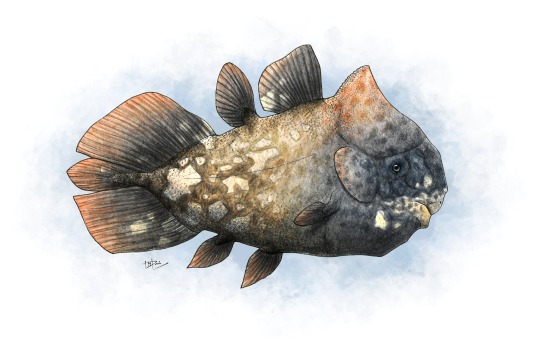
Etymology: Forey’s Fish
First Described By: Cavin et al., 2017
Classification: Biota, Archaea, Proteoarchaeota, Asgardarchaeota, Eukaryota, Neokaryota, Scotokaryota, Opimoda, Podiata, Amorphea, Obazoa, Opisthokonta, Holozoa, Filozoa, Choanozoa, Animalia, Eumetazoa, Parahoxozoa, Bilateria, Nephrozoa, Deuterostomia, Chordata, Olfactores, Vertebrata, Craniata, Gnathostomata, Eugnathostomata, Osteichthyes, Sarcopterygii, Actinistia, Coelacanthiformes, Latimerioidei, Latimeriidae,
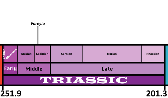
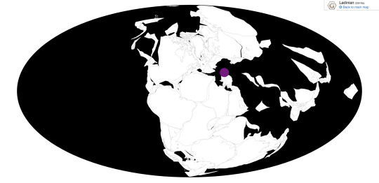
Time and Place: Foreyia lived about 240.91 million years ago, in the Ladinian of the Middle Triassic
Foreyia is known from the Prosanto Formation of Switzerland
Physical Description: Foreyia was a Coelacanth, a sort of Lobe-Finned Fish once thought to be a unique feature of prehistoric ecologies, and now known to survive in two different species today. This is wild, of course, but Coelacanths were weird in many different ways throughout their prehistoric tenure. Foreyia looked only a little similar to its cousins - it had a huge head compared to other Coelacanths, as well as a beak - something that you really only see in ray-finned fish and tetrapods - an underbite, and a horn on its head. That said, its body looks similar enough to other coelacanths, with dorsal fins and a wide tail fin, and large forelimb fins. However, the large size of its head makes it look like a Coelacanth that had been squished extensively, with the body looking quite short and squished compared to its close relative Ticinepomis. We aren’t sure as to what colors it may have been, but since it lived in a tropical region and may have had a similar niche as a Parrotfish, it is reasonable to suppose it may have been colorful. It was also very small, only around 20 centimeters long.
Diet: Given the beak, it’s likely that Foreyia ate hard food, potentially even similarly to living parrotfish - by chipping off algae covered rocks and reef builders, or potentially eating small shelled animals in the tidal pools.
Behavior: Foreyia’s head was huge, and so that likely impacted its swimming style, though it is unclear how. Modern Coelacanths moving very slowly through the water, moving their fins to help propel through. Since Foreyia reduced the size of its fins to an extent, it’s possible that the tail (which was very large compared to the rest of the body) was more vital in swimming, and the head may have been used to help steer (though this is just a hypothesis). The bony shield may have also been helpful in protecting Foreyia from danger, which makes sense ans many predators were present in its environment. This is at least somewhat supported by its strong clavicle muscles. It probably would have spent a significant amount of time grazing, either on small crunchy invertebrates or algae. Today, Coelacanths don’t seem to shoal much; however, that may not have been the case in the past, so we can’t infer a loner lifestyle for Foreyia.
Ecosystem: Foreyia lived in a coastal shelf environment, specifically in a tidal basin that would often become anoxic as the tide went out during the day, meaning that Foreyia had to move around a lot to avoid suffocation. This environment was probably at least somewhat reef or tidal pool like, with a variety of fish swimming around in the ecosystem. There were many ray-finned fish here, including Peltopleurus, Habrichthys, Archaeosemionotus, Saurichthys, Ctenognathichthys, Besania, Prosanticthys, Eoeugnathus, and Ducanicthys. There was also another Coelacanth, Ticinepornis. As for tetrapods, there was the Pachypleurosaur Neusticosaurus, the Helveticosaurid Eusaurosphargis, and the Tanystropheid Macrocnemus. These reptiles would have been major predators of Foreyia.
Other: Foreyia is so weird in its shape that the original authors proposed it was Heterochronic - ie, different aspects of baby Coelacanth anatomy were retained in order to provide useful adaptations for Foreyia. However, some later researchers have cast doubts on this idea, given that baby Coelacanths don’t… actually seem to resemble Foreyia. Clearly, the jury is still out!
~ By Meig Dickson
Sources Under the Cut
Arratia, G., and A. Herzog. 2007. A New Halecomorph Fish from the Middle Triassic of Switzerland and its Systematic Implications. Journal of Vertebrate Paleontology 27(4):838-849.
Bürgin, T., U. Eichenberger, H. Furrer and K. Tschanz. 1991. Die Prosanto Formation - eine fischreiche Fossil-Lagerstätte in der Mitteltrias der Silvretta-Decke (Kanton Graubünden, Schweiz). Eclogae Geologicae Helvetiae 84:921-990.
Bürgin, T., and A. Herzog. 2002. Die Gattung Ctenognathichthys (Actinopterygii, Perleidformes) aus der Prosanto-Formation (Ladin, Mitteltrias) Graubündens (Schweiz), mit der Beschreibung einer neuen Art, C. hattichi sp. nov. Eclogae Geologicae Helvetiae 95:461-469.
Carroll, R. L., and P. Gaskill. 1985. The nothosaur Pachypleurosaurus and the origin of plesiosaurs. Philosophical Transactions of the Royal Society B 309:343-393.
Cavin, L., H. Furrer, and C. Obrist. 2013. New coelacanth material from the Middle Triassic of eastern Switzerland, and comments on the taxic diversity of actinistans. Swiss Journal of Geosciences 106:161-177.
Cavin, L., B. Mennecart, C. Obrist, L. Costeur, and H. Furrer. 2017. Heterochronic evolution explains novel body shape in a Triassic coelacanth from Switzerland. Scientific Reports 7(13695):1-7.
Ferrante, C., L. Cavin, H. Furrer, R. Martini. 2018. Coelacanths from the Middle Triassic of Switzerland show unusual morphology. Swiss Geoscience Meeting.
Fraser, N., and H. Furrer. 2013. A new species of Macrocnemus from the Middle Triassic of the eastern Swiss Alps. Swiss Journal of Geoscience 106:199-206.
Herzog, A. 2001. Peltoperleidus obristi sp. nov., ein neuer, kleiner Strahlenflosser (Actinopterygii, Perleidiformes) aus der Prosanto-Formation (Mitteltrias) von Graubünden (Schweiz). Eclogae Geologicae Helvetiae 94:495-507.
Herzog, A. 2003. Eine Neubeschreibung der Gattung Eoeugnathus Brough, 1939 (Actinopterygii; Halecomorphi) aus der alpinen Mitteltrais Graubündes (Schweiz). Palaeontologische Zeitschrift 77(1):223-240.
Herzog, A., and T. Bürgin. 2005. A new species of the genus Besania Brough 1939 from the Middle Triassic of Canton Grisons (Switzerland) with a discussion of the phylogenetic status of the taxon. Eclogae Geologicae Helvetiae 98:113-122.
McMenamin, M.A. S. 2018. Coelacanth Vestiges. Deep Time Analysis, Springer Publishing.
Scheyer, T. M., J. M. Neenan, T. Bodogan, H. Furrer, C. Obrist and M. Plamodon. 2017. A new, exceptionally preserved juvenile specimen of Eusaurosphargis dalsassoi (Diapsida) and implications for Mesozoic marine diapsid phylogeny. Scientific Reports 7:4406.
#foreyia#foreyia maxkuhni#coelacanth#Triass March Madness#triassic madness#triassic#prehistoric life#paleontology
298 notes
·
View notes
Text
Algorithms and hi-res survey data lead to census of desert shrub in Nevada

- By University of Texas at Austin -
The creosote is the king of the desert. This scraggly shrub dominates the landscape of the American southwest, creating mini-oases from the harsh heat for desert wildlife. In a new study, researchers at The University of Texas at Austin leveraged computer algorithms and high-resolution survey data to conduct the first-ever creosote census – counting every creosote in a 135-square-mile conservation site in Nevada’s Mojave Desert.
The final count was 23 million creosotes among a total population of 66 million plants.

Image: Creosote plants in Las Vegas Valley.A recent University of Texas at Austin study used aerial survey data and computer algorithms to conduct the first ever census of the desert plant. Credit: Michael Young.
The researchers discovered important new information about the plant species, but they also demonstrate how data techniques can improve on conventional methods for studying plant communities.
“This was first and foremost a big data project,” said James “Jake” Gearon, a graduate student at the UT Jackson School of Geosciences who led the study. “The majority of time was data cleaning, data investigation, data prep. By the time you get to analysis, you have discovered so many things along the way you have a path forward.”
The study was published in November 2020 in the journal Landscape Ecology.
The census is a milestone for plant science. Most plant population data comes from samples of fewer than 1,000 plants or aerial surveys that capture community snapshots. This research presents a way to account for each and every individual in a plant community. The scientists also discovered that certain landscape features can influence how big creosotes grow and how far apart they are spaced.
“People are amazed at the size of the dataset. But we tried to avoid being dazzled by size and focus on the interesting things the data tell us,” said coauthor Michael Young, a senior research scientist at the Bureau of Economic Geology, a research unit at the Jackson School.
The creosote research is built on repurposed data collected by Young and colleagues during a 2017 aerial survey that collected aerial photos and elevation data from the Boulder City Conservation Easement in the Mojave Desert.

Image: Creosotes (larger plants) and white bursage (smaller plants) cover the ground in Nevada’s Boulder City Conservation Easement. Credit: Young et al.
The data were originally collected to find burrows belonging to the threatened desert tortoise. But the high-resolution photos (one pixel is equivalent to six inches) combined with the elevation data that measured variations in each square meter of the easement, created a rich resource for new research.
Counting the creosotes involved applying computer algorithms that could distinguish the bushes from the surrounding landscape and other plants. In addition to carrying out the census, the algorithms also extracted information on each creosote’s location, height, and canopy area, from which canopy volume was calculated.They also extracted information on the surrounding landscape, such as relative soil age, and slope angle and direction.
When the landscape and creosote information were analyzed together, the researchers discovered some notable trends about how the landscape influenced plant growth.
They found that direction of the slope, or aspect, was the main control on creosote volume – with the plants growing on east-facing slopes being about five times bushier than plants on west-facing slopes.
“That’s five times more cover on the ground for the critters, for land use, or for understanding just how hot the ground is going to get – that has a huge impact,” Gearon said.
They also found that soil age influences creosote volume, with plants in the younger soil being about 27% larger than plants in the oldest.
The connection between soil age and plant size is well documented, but the influence of hillslope aspect on plant size came as a surprise, Gearon said. That’s because the research record more often relates plant growth to north and south slope directions – with few studies on east and west slopes.

Image: Geomorphic units in Nevada’s Boulder City Conservation Easement. The research found that younger units are associated with larger creosote plants. Credit: Gearon et al.
But this study suggests that growing on an eastward slope could be an important way for desert plants to stay hydrated, with the placement allowing the plants to soak up the sunshine during the cooler, wetter morning hours, unlike westward slopes which receive the most sunlight during the hottest parts of the day when they’re most susceptible to losing water via transpiration.
Erik Hamerlynk, a research ecologist at the U.S. Department of Agriculture, said the study is significant because of the precision of the data that comes from accounting for every individual in a population.
“This is the first time I’ve seen something that takes plot level data and really expands it to a landscape scale, to a basin scale,” Hamerlynk said. “That’s just a huge accomplishment.”
He added that techniques presented in the study could help improve range management practices by offering an in-depth and standardized view of an entire plant community before and after a particular intervention.
The Clark County Desert Conservation Program funded the research.
--
Source: University of Texas at Austin
Full study: “Geomorphic controls on shrub canopy volume and spacing of creosote bush in northern Mojave Desert, USA”, Landscape Ecology.
https://doi.org/10.1007/s10980-020-01149-8
Read Also
AI indicates there are hundreds of millions of trees in the Sahara
#desert#plants#shrub#algorithms#survey data#big data#biology#geology#soil#ecology#environment#earth science
6 notes
·
View notes
Text
Geologists challenge conventional view of Earths continental history stability with new study
In a study led by Illinois geology professor Lijun Liu, researchers used previously collected density data from the Earth’s uppermost rigid layers of crust and mantle — known as the lithosphere — to examine the relationship between craton surface topography and the thickness of their underlying lithosphere layer. The results of the study are published in the journal Nature Geosciences. The lack of deformation within the cratons since their formation makes them the longest-lived tectonic units on Earth — surviving supercontinent cycles like the formation and breakup of the supercontinent Pangea, as well as the lesser-known and more ancient supercontinent Rodina, the study reports. “It is generally accepted that the cratons are protected by their thick underlying mantle roots, or keels, which are believed to be buoyant and strong and thus stable over time,” Lui said. Several recent papers from Liu’s research group directly challenge this wisdom by showing that these mantle keels are actually quite dense. In a 2022 study, the team demonstrated that the traditional view of buoyant craton keels implies that most of the Earth’s cratons would be sitting about 3 kilometers above the sea surface, while in reality, their elevation is only a few 100 meters. This requires the lithospheric mantle below the crust to be of high enough density to pull the surface down by about 2 kilometers, Liu said. In another study, the team used gravity field measurements to pinpoint the density structure of the craton keels to find that the lower portion of the mantle keel is most likely where the high-density material resides, implying a depth-increasing density profile below the cratons. In the new paper, the team shows that the lower portion of the mantle keel that has a high density and tends to repeatedly peel away from the lithosphere above when mantle upwellings, called plumes, initiate supercontinent breakup. The peeled-off — or delaminated — keels could return to the base of the lithosphere after they warm up inside the hot mantle. “The whole process is like what happens in a lava lamp, where the cool material near the surface sinks and the warm material near the bottom rises,” Liu said. This deformation history is expressed in some of the more puzzling geophysical properties observed in the lithosphere, the study reports. “For example, the repetitive vertical deformation of the lower half of the mantle keel allows the seismic waves that vibrate the rock vertically to travel faster, compared to the upper half of the keel, which experienced less vertical deformation,” Liu said. The team also determined that mantle delamination will cause the craton surface to rise, leading to erosion. “This is reflected in the strong dependence of crustal thickness on lithospheric thickness, an observation never made before this study,” Liu said. “In particular, there are two major uplift and erosion events in the past, when supercontinents Rodinia and Pangea each separated, the former causing what is known as the Great Unconformity — a feature in the Earth’s rock record shows no evidence of new deposition, only deep craton erosion. This is the reason why we see pieces of ancient lower crust exposed at the craton’s surface today.” With the help of numerical simulations, the team said that this episodic deformation style of the lower craton keels is how the craton crusts survived the long geological history. “We believe this newly hypothesized lifestyle of cratons will significantly change people’s view on how continents evolve and how plate tectonics operate on Earth,” Liu said. Illinois geology professor Craig Lundstrom and Illinois graduate students Yaoyi Wang, Zebin Cao, Lihang Peng and Diandian Peng; and Chinese Academy of Sciences professor Ling Chen contributed to this study. The National Science Foundation and the National Natural Science Foundation of China supported this research.
0 notes