#East Coast Greenway Alliance
Explore tagged Tumblr posts
Visit Tumblr Blog
Explore Tumblr blogs with no restrictions, modern design and the best experience.
Last Seen Tumblr Blogs


Fun Fact
Tumblr is used by 21% of adults online aged 18-29 years.
Text
April 2024 News: Shoreline Greenway Trail Extension; Jane's Walk Canal History Tour; Ride the State in June

Dear Friend of the Farmington Canal Greenway,
We wanted to wish you a happy springtime and provide you with a few important updates:

The City Services and Environmental Policy Committee of the New Haven Board of Alders will hold a public hearing on acceptance of state and federal funding for the proposed Shoreline Greenway Trail extension into New Haven, which will connect to the Farmington Canal and East Coast Greenway Alliance at Long Wharf. (We will be walking the proposed route on April 20, see below.)
Please come and testify in support of this important bike-ped project! The hearing is in the Aldermanic Chambers on the 2nd Floor of 165 Church Street, beginning at 6pm.
Written testimony can be submitted before the hearing by emailing [email protected].

* Walk the Route of the Future Shoreline Greenway Trail Extension in New Haven, April 20, 9:30am [Re-scheduled from Last Month]

The walk will be led by longtime advocate of a harborside trail, Chris Ozyck, along with Aaron Goode of NHFFCG and the Bioregional Group and Doug Hausladen from New Haven Coalition for Active Transportation and Shoreline Greenway Trail.
The walk will begin at Lighthouse Point Park at 9:30am. There will be an option for people wishing to do a shorter walk to join the group later at Eastshore Park. More details TBA.
RSVP here.
* Rock to Rock Earth Day Ride, April 27

New Haven’s premier environmental fundraising event, Rock to Rock, is celebrating its 16th Annual event on April 27 and registration is now open! Pick from one of six thrilling routes: 2 family rides (1-mile flat, 5-mile-summit); 12-mile; 20-mile; 40-mile; and the metric century, plus park walks! All rides will begin and end in East Rock Park (College Woods) where there is a Kids Bike Rodeo and a Green Fair with live music and food carts.
After you register, you get to choose which Rock to Rock partner organization you want to support. Please consider selecting our partners Farmington Canal Rail-to-Trail Association or Community Placemaking and Engagement Network (CPEN) as one of the organizations you are supporting. Thank you!We hope you can join us for the Rock to Rock Earth Day Ride!
* Jane's Walk: 200 Years of Transportation History on the Farmington Canal, May 4, 10am, Meet at William Lanson Statue

Join us on May 4 for a guided tour of Farmington Canal history as part of "Jane's Walk," a statewide program of guided tours taking place May 4-5 to celebrate the birthday of legendary urbanist Jane Jacobs. Explore 200 years of transportation history, from canal to railroad to beloved multi-use trail, with Aaron Goode of New Haven Friends of the Farmington Canal Greenway. Learn about the engineers, entrepreneurs, financiers, dreamers, and immigrant laborers who built the Canal and created New Haven as we know it today. We will discuss murals, historic sites and other placemaking efforts along the Farmington Canal Greenway that have made the Greenway one of the signature places in New Haven.
Meet at 10am at the William Lanson statue near Sachem Street. The walk is flat and about 2 miles total.
* SAVE THE DATE for Ride The State, June 22, 2024

This is a great opportunity to ride the Farmington Canal Heritage Trail all the way from New Haven to Massachusetts in a supported group ride setting. It is an amazing way to see the many sides of Connecticut including both historic cities and rural scenery. There will be a shuttle returning riders from Massachusetts to New Haven after the ride is complete. “Ride The State” is always a great experience and a unique way of seeing Connecticut! Registration will open soon -- stay tuned to our social media for updates!
* Phase IV Construction Update - Almost Finished!
Phase IV construction continues to advance steadily with the tunnel, new ramps and stairways essentially complete. If the weather remains favorable we anticipate (hopefully!) a project completion date by the time of Rock to Rock Earth Day Ride at the end of April.


Please follow our social media for additional updates on Phase IV.
* CT Trail Census - Get Involved with this Awesome Data Project!

We are really glad to be participating in the CT Trail Census again this year, as we have since 2017. Participating in this research project provides us really valuable data about trail usage in New Haven and across the state. Last year our infrared counters showed that there were over 150,000 trips taken on the trail in New Haven, and the trendline continues to go up, up, up! We need help this year with collecting manual count forms that enable us to calibrate our infrared sensors. Please contact us if you are interested in helping out with this fascinating and useful project – we really need help completing some manual counts to make sure our infrared counter is calibrated correctly!
_________________________________________
As always, thank you for your ongoing support.
Aaron G. New Haven Friends of the Farmington Canal Greenway www.newhavencanalfriends.org facebook.com/NewHavenCanalFriends
0 notes
Text
Amazon LotR Map Analysis
Unfortunately the LotR fandom, Silmarillion fandom, and general Tolkien fandom on Tumblr has seemed either entirely uninterested in this show, or openly hostile to it ever since its announcement. This, to me, is a shame, since the involvement of the Tolkien Estate, together with the learning experiences of the critically panned Hobbit trilogy and the immense budget given to this show all point to a series of good quality and impressive visuals. At the very worst case, we will get to see more Middle-earth on screen, and I for one am thrilled at that prospect.
Anyway, today marked the end of the long and emotionally fraught series of maps released by the “Lord of the Rings on Prime” account on their Twitter, Instagram, and Facebook. Through the whole process, many theories have been going around as to the meanings of the various maps, speculations on the inclusions of certain names, and so forth. Now that we have reached the apparent end of the map releases (since the Ring verse they’ve been accompanied by has been completed), it seems a good time for me to analyze the map in its final form, as well as any pertinent details from the previous incarnations that might appear striking. I’ll break the map down into sections to make it easier to go through all the details.
Without further ado, let’s begin!
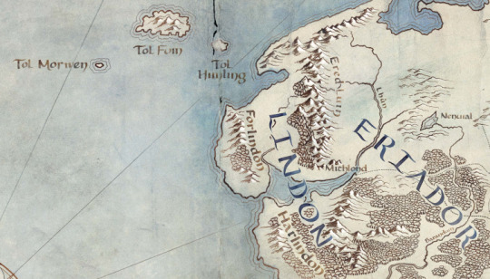
First thing I noticed was the addition of the Western Isles, Tol Morwen, Tol Fuin, and Tol Himling. Some brief lore discussion:
Tol Morwen: This island marks the grave of Túrin Turambar, Niënor Níniel, and Morwen Edhelwen. The Stone of the Hapless, or the Talbor (in Taliska) was the grave marker made for them by the people of Haleth, and was prophesied by Glirhuin the bard to remain standing even if the waves drowned the land, as indeed after befell.
Tol Fuin: This island is the remains of the pine clad heights of Dorthonion, where the people of Bëor dwelt in their land of Ladros. The most interesting facet of its inclusion on this map is that it only appears in The Unfinished Tales, and is not part of any map published along with Lord of the Rings or the Hobbit. This has some interesting implications, as we will discuss later.
Tol Himling: This island is the height where Maedhros had his city and fortress of Himring in the First Age, which was destroyed by Morgoth during their long war. It remains above the sea after the flooding caused by the War of Wrath.
The rest of this section is nothing too new, but there is one minor feature that caught my eye. The hills next to the names Forlindon and Harlindon were not present on any previous version of the map, nor are they present in any published Tolkien map. As we will see later when we examine the land where Gondor will come to be, he coastline is changed there. Both of these are connected, I think, to the fact that this map is in the Second Age, before the Downfall of Númenor. In this time the world was flat, but after the Cataclysm, the flooding caused by the destruction of the island led to great changes in the coastlines of Middle-earth, and I think these hills reflect the prior state of the coast.
Nenuil is included, which may indicate the possible presence of the native men of Eriador, who first met the Númenóreans in the hills to the north of the lake.
The inclusion of the names Lindon, Harlindon, Forlindon, and Mithlond all point to the inclusion of Gil-galad’s kingdom of Lindon in the series, which was the last and largest High-Elven kingdom in the Second Age.
The Ered Luin, Lhûn and Baranduin (Brandywine) are also named, but this is most likely just an indicator that the general region of Eriador will be a setting for the show.

This is a very exciting portion of the map! A lot of information is conveyed by the names here, so let’s break it down.
Eregion was the Noldorin realm founded by Galadriel and Celebrimbor, where the Rings of Power were eventually forged. Ost-in-Edhil was the capital city. Curiously, on this map, Ost-in-Edhil is moved from it’s canon location and placed where the city of Tharbad is meant to be. This may simply be a choice on the part of the showrunners to give Ost-in-Edhil a more interesting location by placing it next to the marshes of Nîn-in-Eilph, the Swanfleet, but at this point we can’t know for sure. Regardless, the inclusion of these names, including the Glanduin and Gwathló rivers, points very strongly to the setting of the show being during or before the forging of the Rings of Power in SA 1600, as Eregion was destroyed soon afterwards.
The Bruinen and the Mitheithel are named, but pointedly Imladris is absent from the location where it was on the previous iterations of the map. This indicates also that the show takes place during or before the forging of the Rings of Power, since Imladris was founded in the following war.
Khazad-dûm is also named, as well as the three mountains Fanhuidhol, Celebdil, and Caradhras which rise above it. Together with the Celebrant river and the valley of Nanduhirion (Azanulbizar in Khûzdul), these names suggest the inclusion of the Dwarves of Moria, or Hadhodhrond as it was called by the Elves in those days. The name Lórinand is also given, which was the name of the kingdom of Silvan Elves ruled by the Sindarin King Amdír. There are excellent meta-analyses of the source texts in existence that show his friendship with the Dwarves of Hadhodhrond was quite strong, which is strange for a Sindarin Elf.
Ninglor and the Hithaeglir and the Anduin are named, but I cannot see any hints there beyond the simple fact that they were around at that time, although the inclusion of the Ninglor (Gladden) is odd.
The North-South road later called the Greenway is present on this map, which is odd to me. I had always thought the road was built to connect Gondor and Arnor together, but since this is before they were founded, I am unsure why it is included. It ends where Fornost will be one day, but currently it is blank. Will we see a new settlement of Men in this place? Perhaps the center of the native Eriador civilization encountered by the Númenóreans?
Lond Daer is included on this map, which lets us know that the show must take place after SA 750/800 when that haven was created by Aldarion the crown prince of Númenor as a source of lumber and supplies for the fleets.
Speaking of lumber, this brings us to the last feature in the section we can comment on: the forests!! The entirety of Minhiriath (Land Between the Rivers) and Enedwaith (Middle-Folk) is covered in trees, and we learn from The Unfinished Tales that many Men dwelt there at this time, some of whom were wary of the Númenóreans due to their logging of the forest. In fact, in later years, the logging grew so bad that the Men were driven out of the lands and took refuge in the last remnants of the forests, most prominent of which was Eryn Vorn, the Dark Forest, which is also included on this map. Perhaps we will see a settlement of these Men here in the show?
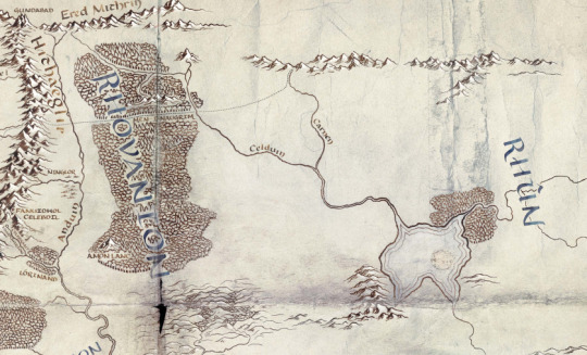
This section was sadly left very unnamed, but there are still plenty of tidbits here!
Gundabad is named, which functioned as the Awakening Place of Durin I, and was considered a sacred place to the Long-beard Dwarves. However, after the War of Wrath, Orcs came fleeing into the northern mountains, and they took it to the Dwarves dismay. Could we see this in the show?
The Men-i-Naugrim, the Old Dwarf Road, is also marked on its way through Mirkwood. However, they add an extension of the road leading all the way to the Iron Hills, which has never been included on any Tolkien map to date. The Long-beards founded their settlement in the Iron Hills in either the First or Second Ages, so I am unsure why it is not labeled here.
Amon Lanc is named on the map, which implies the inclusion of the Silvan Realm of Mirkwood. In the early Second Age, the Silvan Elves of Mirkwood lived across the river from their kin in Lórinand, dwelling about the slopes of Amon Lanc, the Bald Hill, later site of Dol Guldur. Their king was Oropher the father of Thranduil, a Sindarin Elf, who later died in the Last Alliance.
The terrain in this region is interesting in several respects. Firstly, the East Bight in Mirkwood has been filled in, since it was in fact not in existence until the Third Age when it was felled by the Northmen who lived there. Celduin and Carnen are named, but the significance of this is unclear. The most interesting feature of the terrain, however, is the inclusion of a series of forested hills across the Anduin from Fangorn. These occupy the later area of the Brown Lands, and in we learn from Treebeard that this land was once the Gardens of the Entwives, until the war of the Last Alliance when Sauron burned them brown. He says that Men lived near the Entwives and learned agriculture from them. It is unclear if we will see Entwives in the show, or if they are simply presenting a more accurate terrain map for the Second Age.
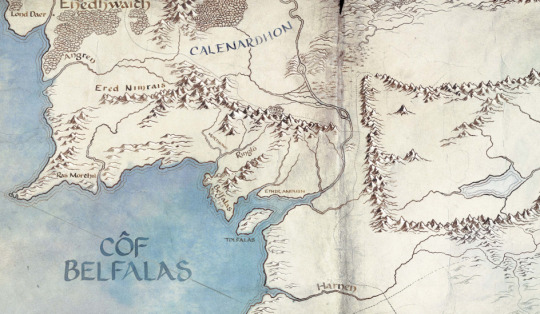
This is another relatively empty map section. However, there are some definite points of interest. Ethir Anduin, Belfalas, Tolfalas, Morthond, Ringló, and Ras Morthil are all geographical areas and features of Gondor, but I am unsure if they have any significance. Ras Morthil is particularly odd, since it is a very obscure place about which we know next to nothing. Drúedain were said to live there, so perhaps we will see them? There is a later unfinished story Tolkien wrote called Tal-Elmar, where the Númenóreans are seen from the perspective of native people living near the mouths of a river in Gondor. Perhaps we will see such a story?
Of particular note is the shape of the coastline. The Anduin does not have a delta, and the coastline is much smaller here than it is on Third Age maps. This is consistent with the lore for the effects of the flooding post-Cataclysm.
Mordor is devoid of names, suggesting that Barad-dûr is not yet built.
The last interesting thing here is the name Côf Belfalas (Bay of Belfalas) which is a name that only occurs in the very very obscure essay by Tolkien titled The Rivers and Beacon Hills of Gondor. It was never published by Christopher Tolkien, and appeared only in the linguistic journal the Vinyar Tengwar. The fact that this name is included here suggests that the rights the show has are far greater than we had previously thought.
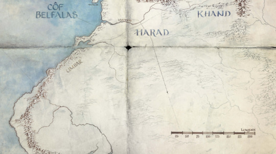
This section is the most new, as well as the least informative. Much terrain has been added, but it is faded quite a lot compared to the rest of the map, and I am unsure what this signifies. Khand is still included, which is very interesting to me. Perhaps we will see these empty areas filled out in a later promotion? So far there have been no new names or made-up named locations, so perhaps they are simply saving them for a later date? Regardless, the possibilities here are virtually endless.
Umbar is interesting in that the city is not marked on the map. We do not have a precise canon date for its founding, but it is odd that it would not be in existence at this time. Even more odd, however, is the fact that a heretofore unknown road is shown leading to its very site, and then off east towards Khand. Perhaps this whole area will be expanded upon at a later date?
This part of the map is only worth commenting on because it is entirely new in terms of the established maps for the Second and Third Ages. In some hasty maps of the First Age, Tolkien shows an eastern range, the Orocarni (Red Mountains) in the east, but it seems that they were further east than these. The identity of these mountains remains a mystery, as we have no new names to speculate with. Perhaps they will also gain some depth.
For the East and South there is the possibility that we will see the Blue Wizards. In Tolkien’s latest notes on the Istari, he said that the Blue Wizards came with Glorfindel in the Second Age around the year 1600, and were instrumental in disrupting Sauron’s plans in the East and South. Perhaps we will see this in the show?

And finally, we have arrived at the most exciting portion of the map: Númenor itself! The island is filled in with all the major names from the Unfinished Tales map, and features all the terrain details we expect. However, its inclusion, along with Tol Fuin from earlier, proves that the show has the rights to The Unfinished Tales, and if the elvish for the Bay of Belfalas is to be believed, it means they have the rights to even more.
So what does all of this mean? Well, based on the dates, there is only one significant global event during the time from SA800-SA1600: the forging of the Rings of Power. All the names for all the places we’d expect to see are present, and many different arenas are included on the map for a truly global showcase of the time. This could include the forging itself, the leadup to it including the political tensions between Galadriel and Celebrimbor and the arrival of Sauron disguised as Annatar, and the War of the Elves and Sauron following after. This war saw the death of Celebrimbor, the creation of Imladris, and the full might of the Númenórean navy.
This will, in my opinion, make for a fun, diverse, and complex show with many different perspectives and characters and races all competing together, as well as the familiar faces and ties to LotR that the show needs to gain popularity with movie fans. Then there’s this:
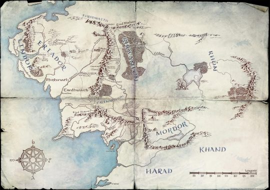
The second-to last map the account released. The inclusion of Arnorian cities like Annuminas and Fornost, as well as Gondorian places like Osgiliath and Minas Anor and Minas Ithil, suggest that the map is teasing the Last Alliance. Perhaps, as has been rumored, the show will be an anthology series, spanning the Forging of the Rings to the Last Alliance. If so, that will be an ambitious project, and one I look forward to with excitement and hope.
#meta#analysis#map#lotronprime#amazonlotr#fandom#lotr#silmarillion#rant#please excuse my absurdly long post#i really wanted to get all of this out.
152 notes
·
View notes
Photo

East Coast Greenway Alliance’s inaugural New York City-to-Philadelphia Ride with lots of Garden State greenway in between. 2-day, 130-mile fundraising ride May 16-17, 2020. Register Early. I believe this will fill up fast! I don't have a bucket list, but if I did, this would be on it! Click here for more info
0 notes
Text
Allen Iverson Virginia is for Hustler shirt
The Virginia native proudly presents his hometown on this Allen Iverson Virginia is for Hustler shirt. The state for a hustler, Virginia is known as the “Mother of Presidents,” because it was the birthplace of eight US presidents: George Washington (in Wakefield, Westmoreland County). Thomas Jefferson (in Shadwell, Albemarle County) James Monroe (at Westmoreland County). Woodrow Wilson (at Staunton), William Henry Harrison (at Berkeley, Charles City County), John Tyler (at Greenway, Charles City County) and Zachary Taylor (in Orange County)) more than any other state. Four of the first five presidents were from Virginia, and seven of the first twelve presidents. The most recent president from Virginia was Woodrow Wilson, the 28th president.
Allen Iverson Virginia is for Hustler shirt, hoodie, sweater, v-neck t-shirt and tank top
Sweater
Tank top
V-neck
Guys tee
Ladies tee
Official Allen Iverson Virginia is for Hustler shirt
This land has talented people, so this Allen Iverson Virginia is for Hustler shirt is worth to be proud of. Virginia was also known as the “Mother of States,”. Because part of the former colony was Kentucky, Indiana, Illinois and West Virginia as well as parts of Ohio. The state located on the East Coast and the largest area located near Virginia Beach. A city of 438,000 people, right next to the Atlantic Ocean. This city noted for having the longest beach in the world. Although most of the state covered in lush greenery. The western part of the state has the Appalachian Mountains creating a majestic setting. The capital of the state, the city of Richmond – also the capital of the Alliance in the American Civil War – is a rich and sunny city full of history and culture.
The post Allen Iverson Virginia is for Hustler shirt appeared first on Picturestees - Cool T Shirt Website.
Source http://bit.ly/2Mpkhza
0 notes
Text
5 Great Cities for Millennial Homebuyers
(TNS)—For millennials who are ready to become homeowners, finding an affordable house in a great community can be challenging. With housing inventory historically low, real estate in major metro areas is at a premium. It’s no surprise, then, that young buyers are moving to the suburbs, according to the 2017 Home Buyer and Seller Generational Trends Report by the National Association of REALTORS®.
Among millennials surveyed, 57 percent bought a house in the suburbs, spending an average of $205,000. Meanwhile, only 12 percent bought in an urban or central city. Affordability, convenience to work and neighborhood quality were among the top requirements for these buyers.
Using this information, we identified five cities that offer some combination of affordable housing, economic growth, job opportunities, proximity to major metro areas and recreational activities.
Great cities for millennial homebuyers:
Lancaster, Pa.
Columbus, Ohio
Garner, N.C.
Petersburg, Fla.
West Des Moines, Iowa.
Lancaster, Pa. Population: 59,218 Median value of housing: $109,300
One of the oldest inland cities in the country, Lancaster boasts unique features, such as the country’s oldest continuously running farmers market. It’s also home to an established arts community and a network of independently owned businesses.
There are a number of homes available in Lancaster, including new construction. There were 200 new housing units built in Lancaster in 2017. This year, the city is on track to add 125 more, according to Marshall Snively, president of Lancaster City Alliance.
“In the last 10 years, we’ve had more than $1.5 billion in public and private investment, including residential development, and more is on the table,” Snively says.
Nestled between Harrisburg and Philadelphia, Lancaster is a good option for people who want to work in one of these larger cities but own in a more affordable location. Residents can take a train to Harrisburg in less than 35 minutes, and trains into New York City take about two-and-a-half hours.
Local businesses abound, so many residents don’t have to look beyond the city for jobs. Medical center Lancaster General Health has a network of 300 physicians and more than 3,600 employees. Fulton Bank, one of the region’s most prominent financial institutions, is headquartered in Lancaster.
The city has a strong arts culture, which supports a variety of vintage and antique stores, as well as outdoor markets and performing arts. Gallery Row downtown consists of three blocks of galleries, restaurants and retail.
Columbus, Ohio Population: 860,090 Median value of housing: $131,800
You can own a home in Columbus without breaking the bank. Even in some of the more expensive neighborhoods, like Harrison West, you can find three-bedroom, two-bath homes for under $250,000.
Columbus supports many industries, including healthcare, education, finance, manufacturing, retail and technology. Columbus’ largest employer, the Ohio State University, has more than 30,000 full-time workers. Nationwide Insurance is also headquartered here, with about 13,000 full-time employees.
Columbus offers amenities for just about everyone. Kayakers can enjoy Columbus’ waterways, like Big Darby Creek, Griggs Reservoir and the Scioto River. There are also miles of bike trails and thousands of acres of parkland to hike.
Nightlife includes comedy clubs and live music venues, as well as hundreds of restaurants. Additionally, there are many large-scale attractions, like the Center of Science and Industry as well as the Columbus Zoo and Aquarium.
Garner, N.C. Population: 28,776 Median value of housing: $164,800
This small town is about six miles south of Raleigh and is also near the Research Triangle, which includes Duke University, North Carolina State University and the University of North Carolina at Chapel Hill.
For people who work in any of these areas, Garner offers more affordable housing than some of the other nearby communities.
Garner’s business landscape is a mixture of information, utilities, retail and public administration. Companies like Butterball and Direct Distributors are headquartered in Garner. The median household income in Garner is $59,812, above the national median of $57,617, according to Census data.
Outdoor enthusiasts will appreciate Garner’s 1,200 acres of parkland and open space. White Deer Park offers bikers, runners and walkers two miles of paved trails, playgrounds, an arboretum and a 2,500-square-foot nature center.
Garner also has a mix of chain stores, shopping plazas and locally owned businesses. Local watering holes, like The Beerded Lady, offer a place for residents to see live music.
St. Petersburg, Fla. Population: 260,999 Median value of housing: $154,800
St. Petersburg has rejuvenated its downtown, which is home to a mixture of business offices, residential property, restaurants and entertainment.
The Gulf Coast city boasts more than a dozen companies that employ over 1,000 people, including HSN, Raymond James Financial and Jabil Circuit, in addition to many other mid- and small-sized companies.
Mayor Rick Kriseman, who was just recently awarded the 2018 Small Business Advocate award by the U.S. Conference of Mayors for his commitment to small businesses, said that creating opportunities for young people is a top priority for St. Petersburg. The city’s Grow Smarter initiative developed by the city and the Chamber of Commerce to assess, develop and create programs to grow the local economy is an example of that focus.
“We are working hard to ensure we are an inclusive and welcoming city where people of all ages can grow and thrive,” Kriseman says. “We are specifically aiming to bolster and support our population of young professionals, as their skills and interest align well with our Grow Smarter economic development strategy.”
St. Petersburg is home to world-class museums, such as the Salvador Dali Museum and the Fine Arts Museum, as well as chefs honored with James Beard awards, including Lauren Macellaro of The Reading Room.
The city hosts events like the Firestone Grand Prix and is home to the Tampa Bay Rays baseball team.
West Des Moines, Iowa Population: 64,560 Median value of housing: $195,500
West Des Moines borders Des Moines to the west, about eight miles from Des Moines International Airport. This small city reaps the benefits of the booming financial and publishing industries in Des Moines while retaining a grass-roots community.
“What we’re seeing is that a lot of young people are buying in our older neighborhoods,” says Clyde Evans, director of Economic Development for West Des Moines. “They’re fixing up houses from the ’60s, ’70s and ’80s. It’s affordable for them to do that here.”
Finance and insurance companies, including Wells Fargo, Farm Bureau and Athene, are located in West Des Moines. Small businesses also make up a large part of West Des Moines’ economy, adding to the 2,800 businesses in the city, according to the West Des Moines Chamber of Commerce. West Des Moines is only 11 miles east of Waukee, the future home of Apple’s $1.375 billion data center announced last year.
West Des Moines has a variety of restaurants and shopping destinations, including Jordan Creek Town Center and Valley West Mall. There are also microbreweries for beer connoisseurs, like locally owned Twisted Vine.
The 632-acre Raccoon River State Park offers an array of activities like fishing, boating and even swimming along the 500-foot beach, which is part of Blue Heron Lake. There’s also an extensive network of almost 50 miles of greenway trails, park trails and side paths.
©2018 Bankrate.com Distributed by Tribune Content Agency, LLC
For the latest real estate news and trends, bookmark RISMedia.com.
The post 5 Great Cities for Millennial Homebuyers appeared first on RISMedia.
from News | RISMedia http://ift.tt/2FA7SSF via IFTTT
1 note
·
View note
Video
youtube
Virginia to North Carolina, Weeks 5 & 6 of River Relay with East Coast Greenway Alliance! #sustainableliving
0 notes
Text
3,000-mile-long bike path coming to the East Coast
3,000-mile-long bike path coming to the East Coast
The East Coast Greenway Alliance (ECGA) has already completed just under a third of the 3,000-mile-long path, which would ultimately connect 15 states. The ECGA uses its resources to fund and organize local groups and volunteers to build sections of the path. The Durham, North Carolina-based organization has highlighted that this approach fosters a feeling of community ownership of the path while…
View On WordPress
0 notes
Photo

We will be at this year's New England Bike-Walk Summit in Providence, RI! Learn more about this East Coast Greenway Alliance event: http://bit.ly/186bBkO
2 notes
·
View notes
Text
Got Trail? Get Bike Tourist Dollars
The tourism industry is a powerhouse: the World Travel and Tourism Council calculated its pre-pandemic value at 10.4% of global GDP (USD 9.2 trillion). Of course, like many industries, tourism took a hit during the pandemic and might not fully recover until 2024.
But the domestic tourism market is rebounding—Americans want to “revenge” spend on travel. The US Travel Association’s June report found that 62% of American adults “feel comfortable taking a vacation,” reflected in the uptick in air travel over the 4th of July weekend.
Add in Americans’ new love of cycling, and it’s reasonable to think that businesses near a bike trail can be part of a trail-related tourist boom.
Before the pandemic, the Outdoor Industry Association said that Americans spent $97 billion on “wheel sports” (cycling and skateboarding)—more than $13 billion on gear and nearly $83 billion on trip-related expenses.
Source: “The Outdoor Recreation Economy,” Outdoor Industry Association.
Flash-forward to the pandemic: bicycle sales soared as people sought a new hobby or safer mode of transportation.
We asked Gary Smith, owner of TLC for Bikes in Raleigh, NC, if that was his experience, and we got a resounding “yes.” High demand means it now takes at least 3–4 months of lead time to find the components he needs to build a new bike.
This demand means that businesses located on or near a bike trail may be sitting on a tourism gold mine. People are ready for adventure, and bike tourism checks many boxes—it’s outdoors, socially distanced, and possibly a more sustainable method of travel.
Economic Impact of Trails
Trails draw tourists—and the tourism industry, in turn, supports many small businesses across various sectors. For example, North Carolina Department of Commerce Secretary Machelle Baker Sanders told WRAL that more than 45,000 small businesses depend on NC tourism spending.
Bike touring’s economic potential is staggering even when narrowed down to specific trails.
One model showed that Baltimore could have total retail spending up to $113 million per year and support up to 1,163 workers by building 10 new miles of trail to complete its 35-mile trail network. Those numbers include the impact of both neighborhood and tourist users, but it’s still impressive.
The East Coast Greenway (ECG), a 3000-mile route connecting Maine to Florida, is another example. The ECG Alliance says that “spending from trail users induces an additional $59,726,000 in annual spending in the region”—all related to the 70 miles of trail in the Triangle area of North Carolina. Another study shows that completing the ECG near Philadelphia could generate $840 million in annual tourism benefits for that region.
Even partially finished trails have an economic impact: New York’s 750-mile Empire State Trail generated “$274 million in annual economic impact” 3 years before the route was even finished.
What Bike Tourists Want
Cyclists are hungry, thirsty, and tired tourists who want to support small-town businesses. They value car-free trails and seek to show their appreciation by spending money in the local communities.
Cyclists can only support businesses they know about, though—and often, it’s not clear what’s available. Is there a brewery near the trail? If so, does “near” mean 2 or 10 miles from the trail? Is the route even rideable (e.g. paved with a low-traffic or wide shoulder)?
Consider working with your local tourism organization or chamber of commerce to create a tourism nerve center that helps cyclists access the information they need. If that isn’t an option, collaborate with other small business owners to develop wayfinding solutions and a cyclist-friendly guide to the area.
Small Business Ideas for Trail Towns
Here are some services that bike tourists need:
Bicycle Rentals
Some cyclists bring their own bikes, but many need to rent one. Shops that rent bicycles, tour operators that rent out unused bikes, and bike share franchises near trailheads could do well.
Bicycle Repair
Inevitably, something always breaks on a bike tour—like a flat tire, a broken spoke, or a snapped cable. Bike repair services—a bike shop offering trail-side pickup or mobile repair service—are needed.
Entertainment
Most bike tourists don’t ride all day, which means they need off-the-bike entertainment options. This includes local shopping (with shipping options, of course, as no cyclist wants to carry more weight), music, and guided tours.
Cyclists will pay for guided tours, especially to visit sites located some distance from the trail. A beautiful waterfall or historical site within a short driving distance of the trail is a shuttle-and-guide tour opportunity.
Food and Drink
Cyclists eat and drink constantly—it’s their fuel.
Restaurants, coffee and sandwich shops, bakeries, breweries, wineries, and even grocery stores can benefit from bike tourism by offering dine-in service, as well as meals and snacks packaged to-go in bike-friendly containers.
Lodging
Bikers need to sleep before, after, or during a tour on a multi-day trip. Luxury B&Bs, inns, and campgrounds all fit the bill if the lodging is easily accessible from the trail and has bike storage options.
Shuttle Service
Bike tourists need a lift sometimes. Scheduled shuttle services (e.g., to return to the starting point on a 1-way point-to-point route) or ad hoc pickups (e.g., ride abandonment due to bad weather or mechanical breakdowns) are always welcome.
If you have a trail nearby and you’re ready to start a business helping bike tourists, Lendio can help you find the business loan you need to fund your dream.
The post Got Trail? Get Bike Tourist Dollars appeared first on Lendio.
from Blog – Lendio https://ift.tt/2W3xyoc via IFTTT
0 notes