#Divergent Plate Boundary
Text
Plate Tectonics: A Comprehensive Guide
Introduction
Plate tectonics is a fascinating and crucial geological concept that helps us understand the dynamic nature of our planet. It explains the movement of Earth’s lithosphere, the outermost shell of the Earth, and provides insights into various natural phenomena such as earthquakes, volcanoes, mountain formation, and the distribution of continents and oceans. In this SEO article, we will…

View On WordPress
#Convection Current#Convergent Plate Boundary#Divergent Plate Boundary#Earth#earthquakes#Fossil Evidence#Plate Boundaries#Plate Tectonics#Ridge Push#Slab Pull#Volcanic Activity
0 notes
Text
HE'S NOT JUST GONNA BREAK THE BED HE'S GONNA CREATE A MASSIVE EARTHQUAKE THAT'LL THE BE REASON WHY A NEW DIVERGENT PLATE BOUNDARY IN KOREA WAS FORMED SEPARATING BOTH NORTH AND SOUTH, SENDING THE WHOLE UNDISCOVERED ANIMALS UP IN THE SHORE FROM THE DEEPEST OF MARIANA TRENCH BC OF A TSUNAMI WELCOME TO SCIENCE CLASS
#enhypen hard headcanons#enhypen hard hours#jake smut#enhypen hard thoughts#enhypen smut#jay smut#heeseung smut#sunghoon smut#enhypen oneshots#heeseung hard headcanons#heeseung hard thoughts#heeseung x reader#heeseung x y/n#heeseung scenarios#heeseung fanfic#heeseung imagines#heeseung fanfiction#heeseung oneshots#heeseung ff#enhypen heeseung smut#enhypen fanfiction#enhypen scenarios#enhypen ff#enhypen fanfic#heeseung x you#lee heeseung smut#lee heeseung fanfiction#lee heeseung x reader#lee heeseung imagines#lee heeseung ff
448 notes
·
View notes
Text
Submitted via Google Form:
Hi, I'd like to build a planet with land across the entire planet that is mostly an alpine. I'm thinking that the majority of the land will be tall mountains with almost all shorelines being tall cliffs so even areas close to the ocean can quickly become tall mointains. Places near the equator will have the highest mountains to offset being closer to the sun. How about resources though? What would be abundant, what puld lack? How about other geographical features and conditions that allow a planet to look like this?
Tex: What happens when the tectonic plates meet? Mountains are created via only one type of plate movement (Wikipedia), but due to physics the opposite side of that plate would create the opposite result (Wikipedia). In order to dissipate the forces caused by a plate causing convergent and divergent boundaries, the horizontal movements of a transformation fault would develop (Wikipedia).
Resources can be boiled down to approximately two things: what grows in water, and what grows in soil. For the former, oceans, seas, lakes, and related areas would need to exist and be large enough to develop life of higher trophic levels. For the latter, it would need enough erosion of rocks to create soil, and be propagated by bacteria to facilitate a healthy environment to propagate photosynthetic life and the upper trophic levels that rely on it. (Birds exist, but also birds must roost, so for all intents and purposes they rely on what grows in soil.)
Anything that has above-water places high enough to create what we would subjectively perceive as mountains would have to be an extremely geologically-active planet, where the plates are constantly moving. This would mean things like lots of volcanoes, and likely an atmosphere saturated in gases like sulfur. Extremophiles can grow in these conditions, but because of energy conservation in a geologically-hostile environment, they’re not likely to grow very big.
If you wish for something different, it might be a “dead” planet, in which there’s little geological activity and the state of things like mountain ranges and placement of oceans are effectively locked into place. This would mean an inert core, and possibly a dying planet or else one in a solar system where it’s faced with a dying sun or outside the goldilocks zone of a reasonably active sun.
Addy: So, resources. That's my jam. If you've got a heavily alpine area, you're generally on mountains or mountain slopes, which generally means you're going to be on a whole bunch of rock. That rock could be sedimentary or metamorphic (igneous is also possible, basalt mountains do exist), but it's still rock. Things that rely on heavy amounts of soil - sand, clay, loam, otherwise - will struggle to form into industries.
You might have 3-4 feet of soil ("soil" includes sections that are mostly gravel – if you're looking for dirt, probably only a foot or two). Looking at a couple examples, I'd say you're probably going to get sandy loam, loamy sand, and gravelly loam. Great drainage, not good for food crops. Since you're alpine, that's going to mean you're above the tree line, so timber is going to be scarce as well. Neutral pH to somewhat alkaline, if that matters to ya. Also, above the tree line, the winds get to be very, very harsh - harsh enough that most plants can't survive up there, so crops are doubly not an option.
If you've got a freeze-thaw cycle, then the ground is going to sprout rocks every year in the spring (literally, the freeze-thaw cycle pushes rocks up towards the surface from under the ground, so you get new rocks in your fields every spring as it starts to thaw), so stone for walls and homes will be plentiful. Insulation will likely come from packed earth (e.g. Icelandic turf homes) or animal hides (e.g. yurts). Without good soil for growing, you're going to likely see a lot of animal husbandry - yaks, goats, oxen, and sheep. Maybe small horses, but no large horses; large, Western horse breeds don't do well if they're only grazing - they generally have feed grown for them. Draft horses are large enough that they have to have food grown for them. But ponies are an option.
Your sand will likely be difficult to get separated from the loam/gravel, so glass will be a tricky industry. Clay will be hard to find, so pottery is limited. Also limiting those industries is a lack of easily available fuel - without timber or peat, you've got limited options on what you have available to burn.
If, by alpine, you're also talking about mountain slopes (and maybe valleys?), then you'll have lots of timber. Lots and lots and lots of timber, so long as you don't clear-cut. Berries will be plentiful in the spring and fall, you'll generally have a decent supply of water, you can grow crops if you're careful about your growing seasons (and the ground acts as a refrigerator, so root cellars and similar structures act as a way to preserve food through the winter months), and you've got wild game to supplement.
Animal husbandry is still an option, though you'll almost certainly need to grow feed to keep them fed over the winter. Goats would do better than sheep, I think, but birds (chickens, ducks, partridge, geese) would probably be the easiest animal to raise. With birds, you'll also get down, which will help for quilts and bedding to keep yourself warm at night. Sheep/goats will get you wool, which will be good for clothing to keep warm. If you've got different animals, whatever birds/mammals they've got nearby that can fill the niche.
For fuel, you've got wood and charcoal. Charcoal is made from wood, and it burns hotter and cleaner than wood. Good for large kitchens… or for kilns. Or for metalworking. Or for writing/art. Wood is easier to get, and more suitable to everyday use.
Valleys tend to accumulate clay, gravel, or sand, depending on how fast the water flows. Steep slopes mean fast water, so you'll mostly get gravel. Mild slopes mean slow water, so you'll get a lot of clay (such as many river deltas, where they meet the ocean). Moderate slopes mean medium-speed water, so you'll get sand (or sand with gravel). River sand may not get you high-quality glass, but you can still make basic glass out of it. When the rivers freeze in the winter, you'll have lots of ice. That can be stored underground in ice houses, so that you have ice year-round.
For lime/quicklime, you'll need shells (so beach) or limestone (so depends on mountains type). Lime is used for a variety of things - making mortar for bricks, removing impurities when making iron, making concrete, etc - but you need limestone (or shells, like oyster shells) and fuel to make it. So that really depends on the type of stone the mountains are made of.
Salt may or may not be plentiful, depending on what the mountains are made of. You've got very little ocean access (since cliffs), so drying out seawater for salt isn't going to be effective for large-scale production.
Either way (with or without trees), trade will be difficult. Overland trade will have to deal with snow, ice, and uneven terrain (plus possible food issues for pack animals). Sea-based trade would have to deal with getting goods up or down those massive cliffs without damaging or dropping them.. and also getting people down there, too. Huge altitude changes.
Wootzel: If your main concern is having your planet chilly, you could look at Earth during the last ice age as inspiration. This would probably result in having a planet with a LOT of nigh-unlivable area near the poles, but it could be a way to make most of your land quite cold without having to rely as heavily on high altitudes, if that’s something you want to look into.
18 notes
·
View notes
Text
Convergent and divergent tectonic plate boundaries are two of the three main types of plate boundaries, along with transform boundaries. They represent two distinct ways in which tectonic plates interact and move, resulting in different geological features and processes.
39 notes
·
View notes
Text

Volcano Map for Jom'Gol. Orange dots represent active or semi-active volcano regions globally. The lines in between represent tectonic plates, red being converging, blue being diverging, and yellow being transform boundaries.
#art#digital art#artists on tumblr#worldbuilding#speculative biology#speculative evolution#spec bio#jomgol#spec evo#speculative worldbuilding#plate tectonics#volcanism#mapmaking#maps#planets
11 notes
·
View notes
Text
THESE MOUNTAINS SHOULD NOT EXIST
a rant/essay about dreamland's topography

disclaimer: i am a second year ENVS student and may get some details wrong. i don't really feel like sending this to my advisor (the local geologist) to proofread, so it'll have to do. i think she has more important things to do right now than read my kirby rant
to begin, we have to establish some basic rules about geology:
how do mountains form?
mountains come to be in a few ways: shifting plates and hot spots. hot spots are technically also to do with shifting plates, but we'll get to that later. let's talk about the plates first.
there are two kinds of tectonic plates: continental and oceanic. ocean plates are denser than continental plates, which means when an ocean and continental plate converge, the ocean plate will subduct under the continental plate. when two continental plates converge, because they are of similar density, they will collide. this process creates mountains.
mountains created by converging continental plates can be seen, for example, with the Himalayas. in this case, the mountains were formed by the Indian plate pushing up into the Eurasian plate. this method is off the table for dreamland because it is shown to be a peninsula (or at least a thin strip of land) surrounded by water.
ocean-continental convergence also creates mountains, but in a different fashion. this is the more relevant method because dreamland also has a volcano, an active one at that.
when ocean plates subduct under the land, they are forced down into the earth until they reach a melting point. sometimes this newly formed magma travels back to the surface, creating a hot spot. if this magma breaches the surface, it forms a volcano (that eventually cools into a mountain). this method can be seen in the Cascade mountains and the Andes.

the volcano/mountain's proximity to the coast depends on how steep the ocean plate's descent is. if we take a look at how close dreamland's mountains are to the shore...

...the ocean plate would have to be hitting its melting point almost immediately after subducting. forgive me for thinking this is unrealistic.
however, the inclusion of a volcano in this range is realistic! an O-C convergence would create a volcano like this. its portrayal within the show isn't really correct, but that's a post for a different day.
how this could potentially happen
not all hope is lost for the ocean-bordering mountain range, sort of. there are a few things that could have happened in popstar's history to cause something like this.
firstly, we should look at the Appalachian mountains. how did they get there? the North American plate is bordered on its east side by a mid-ocean ridge, where new crust is being created.
the Appalachians came to be around the time Pangea was coming together--the collision of the North American and African plates created the mountain range, and over time Pangea split apart, forcing the mountains away.
any map of tectonic plates will reveal a large split through the Atlantic ocean--this is a divergent boundary, where plates are being pushed apart in favor of creating new lithosphere (crust/upper mantle).
so, with all this in mind, there are a few things it could mean for our mountain range:
dreamland is actually an island, and we don't know because the overhead view doesn't show it
this would mean hot spots are relevant again: if a plate moves over a hot spot, magma can form into islands, especially volcanic ones. this is how Hawaii was formed, and why it is prone to volcanic activity. given that dreamland is an island, this would explain the presence of mountains. Hawaii's tallest peaks are still inland rather than right on the coast, but it's close enough.
2. a new fault/divergent boundary formed between dreamland's mountains and the opposing plate that created them
new faults aren't uncommon, though they don't always succeed. the New Madrid Seismic Zone, for example, made a small break in the American Midwest, but didn't get much farther than that. a successful fault or new divergent boundary could potentially push dreamland's mountains away from their neighboring plate. this is more like what happened to the Appalachians--though they're pretty far inland, so take that as you will. the new boundary would have to form quite close to the mountain range for them to be right on the shore like this.
3. the water has eroded away the land leading up to the mountains
now this isn't really one i have any backup for, i just wanted to throw it in because it came to mind. while it's possible for the ocean to have greatly eroded the land if it's been here for a long time, the mountains would still have to be very close to the shore to end up where they are. dreamland's proximity to the ocean could imply it has a delta at the end of the peninsula, and maybe one of the routes is along the mountains so the channel eats away at the shore for a while...who knows. but this one doesn't feel too realistic, either.
conclusion
as far as i'm aware, it isn't completely impossible for these mountains to exist, but they aren't exactly realistic, either. their proximity to the shore leaves too many questions that are hard to answer without any information about popstar's history and plate tectonics. most likely, dreamland is on an island, and was created as its plate moved over a hot spot. the existence of an active volcano implies that it is still sitting over this hot spot, and will eventually move away from it.
i must really miss my geology class if this is what i'm doing with my spare time. thank you for reading.
#kirby#kirby right back at ya#rhyn rambles#long post#i'm taking hydrology next term which means i might end up being annoying about something else soon#at the very least the river system looks pretty realistic#rivers are harder to mess up than mountains#i'll complain about the volcano if anyone's interested#i have some things to say that include comparing it to dante's peak
17 notes
·
View notes
Text
Miasma Streams and Elements
Let's do it again. Editing and completing things said there.
Also thanks @crookedvoidbird for talking about the parasite.
So here's our default map:

In the past, a meteorite crashes into Mount Vellenge (and destroys the giant crystal that was there). The meteor parasite that came along settles there. It starts producing miasma that spread around the world, but also creates some underground rifts; we can imagine it does that by growing very long tentacles or roots. They are aiming for the main elemental sources scattered over the continent.
Even if it's a move from a living organism that aims to survive, the path that the new rifts take isn't purely from its will and is constrained by geology to some extent, so they happen where the earth's crust already shows some weakness or near tectonic plates boundaries.

So the rifts are created, miasma also goes into them and flows around the world. Most of the time this path is underground, but sometimes it goes higher and reaches ground level. This is where we get our miasma streams as shown in the game. They look like rifts too; what we see is a bridge above some kind of void and very strong winds all around.
The miasma that travels through those rifts gets imbued with elements on its way. Eventually it goes back to Mount Vellenge to bring the food —the elements— to the parasite. A secondary path is made after the main water source to allow the cycle to repeat and ensure permanent feeding.
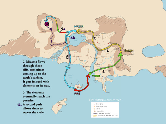
A new rift is created by the parasite, circling Mount Vellenge, leading to a new miasma stream. On their usual cycle, the streams/elements don't merge together, they just swift and let the place to the next element. But if they're stuck together, like they end up doing around Mount Vellenge, the elements are forced to fuse and give birth to the unknown element. The parasite now has a solid barrier to prevent predators from coming too close (like humans who'd want to destroy it by any chance).

(Compared to the initial (black) rift that is located underground, the unknown element (bright yellow) travels on a higher level so they don't meet.)
But geology and randomness are still a thing. Located where three plates meet/diverge in the ocean, a new breach opens to the south, weakened by the miasma stream that runs nearby, unplanned by the parasite. Some miasma goes in there too and ends in a closed circle underground, the same way it does around Mount Vellenge. A new stream of unknown element is made. Some of it finds its way between smaller breaches until reaching Lynari island and rising to the surface there, in the desert.
And as we see in game, there's still some enigma to solve there to find it, but that's not the topic.

Voilà. More notes under the cut.
Note 1: this is basically how I imagine the miasma stream to flow when it reaches the land just after the wind source, when it seems to pop up from the ocean.

Note 2: If I really wanted to stay true to the cycle from the game, the earth and fire sources should be swapped. I'll say screw that after all. I already diverge from canon for many things and it would just affect the gameplay/traveling options, which is not exactly my problem.
So the miasma streams' elements change each year like this:

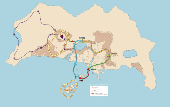
Note 3: If you wonder why I suggest there's a whole continent that isn't seen in game, here's why.
Note 4: I'll never pretend that everything makes sense geologically wise. Also I'm just doing my headcanons with my own logics and subjects affinities, but I'm sure there could be other nice explanations for miasma streams. Just gonna go with that for now. If needed, it has time to evolve before I get to write more post-game stuff :')
As a last bonus, there could be other elemental sources on the continent, it's just not my point of focus. But something like this could also be true and reinforce the cycle (more sources to the north of the continent are possible):
#ffcc headcanons#ffcc#crystal chronicles#spent too much time on that i need to stop#there are many other related topics that could be addressed but later#next thing to do is rearranging my tags on this blog cause it's a big mess
9 notes
·
View notes
Text
Arctic Ocean
The world's smallest and most shallow ocean. It is also the coldest and least salty ocean.
About the size of Russia.
The Arctic Ocean is divided by an underwater ocean ridge called the Lomonosov ridge
Located at the North Pole, the Arctic Ocean has polar ice. Over the years, glaciers have melted threatening sea levels to rise.
Despite the IHO recognizing it as the “Arctic Ocean”, some oceanographers still call it the “Arctic Sea”.
The Arctic Ocean is the most diverse in terms of fish species. It has a wide variety of marine species including whales, jellyfish, etc.
But because of its frigid temperatures, it has little plant life. This makes it one of the most fragile ecosystems on the planet.
Area
Total: 15.558 million sq km
Area - Comparative: Slightly less than 1.5 times the size of the US
Includes: Barents Sea, Beaufort Sea, Chukchi Sea, East Siberian Sea, Greenland Sea, Kara Sea, Laptev Sea, Northwest Passage, Norwegian Sea, and other tributary water bodies
Coastline: 45,389 km
Ocean Volume: 18.75 million cu km
Percent of the World Ocean Total Volume: 1.4%
-------------------------------------------------------------------------
Bathymetry
Continental Shelf: A rather flat area of the sea floor adjacent to the coast that gradually slopes down from the shore to water depths that are typically less than 200 m (660 ft). Dimensions can vary: they may be narrow or nearly nonexistent in some places or extend for hundreds of miles in others. The waters above the continental shelf are usually productive in both plant and animal life, both from sunlight and nutrients from ocean upwelling and terrestrial runoff. More than one quarter of the Arctic sea floor is continental shelf. The Eurasian shelf is very wide extending out 1,500 km (930 mi) and is the largest continental shelf in the World.
Barents Shelf
Beaufort Shelf
Davis Sill
Chukchi Shelf
East Siberian Shelf
Kara Shelf
Laptev Shelf
Lincoln Shelf
Continental Slope: Where the ocean bottom drops off more rapidly until it meets the deep-sea floor (abyssal plain) at depths exceeding 3,000 m (9,850 ft) water depth. The deep waters of the continental slope are characterized by cold temperatures, low light conditions, and very high pressures. Sunlight does not penetrate to these depths, having been absorbed or reflected in the water above. The continental slope can be indented by submarine canyons, often associated with the outflow of major rivers. Another feature of the continental slope are alluvial fans or cones of sediments carried downstream to the ocean by major rivers and deposited down the slope.
Litke Trough
Novaya Zemlya Trough
Svyataya Anna Trough (Saint Anna Trough)
Voronin Trough
Abyssal Plains: At depths of over 3,000 m (10,000 ft) and covering 70% of the ocean floor, are the largest habitat on earth. Sunlight does not penetrate to the sea floor, making these deep, dark ecosystems less productive than those along the continental shelf. Despite their name, these “plains” are not uniformly flat; they are interrupted by features like hills, valleys, and seamounts.
Baffin Basin
Canada Basin
Fram/Amundsen Basin
Greenland Abyssal Plain
Iceland Basin
Makarov Basin
Molloy Deep; note - deepest point in the Arctic Ocean
Nansen Basin
Norwegian Basin
Mid-Ocean Ridge: Rising up from the abyssal plain, is an underwater mountain range, over 64,000 km (40,000 mi) long, rising to an average depth of 2,400 m (8,000 ft). Mid-ocean ridges form at divergent plate boundaries where two tectonic plates are moving apart and new crust is created by magma pushing up from the mantle. Tracing their way around the global ocean, this system of underwater volcanoes forms the longest mountain range on Earth. Fracture Zones are linear transform faults that develop perpendicular to the line of the mid-ocean ridge which can offset the ridge line and divide it into segments.
Gakkel Ridge
Mohns Ridge
Undersea Terrain Features: The Abyssal Plain is commonly interrupted by a variety of commonly named undersea terrain features including seamounts, guyots, ridges, and plateaus. Seamounts (see Figure 1) are submarine mountains at least 1,000 m (3,300 ft) high formed from individual volcanoes on the ocean floor. They are distinct from the plate-boundary volcanic system of the mid-ocean ridges, because seamounts tend to be circular or conical. A circular collapse caldera is often centered at the summit, evidence of a magma chamber within the volcano. Flat topped seamounts are known as guyots. Long chains of seamounts are often fed by "hot spots" in the deep mantle. These hot spots are associated with stationary plumes of molten rock rising from deep within the Earth's mantle. These hot spot plumes melt through the overlying tectonic plate as it moves and supplies magma to the active volcanic island at the end of the chain of volcanic islands and seamounts. An undersea ridge is an elongated elevation of varying complexity and size, generally having steep sides. An undersea plateau is a large, relatively flat elevation that is higher than the surrounding relief with one or more relatively steep sides. Although submerged, these features can reach close to sea level.
Lomonosov Ridge
Gakkel Ridge
Alpha Ridge
Mendeleev Rise
Chukchi Plateau
Ocean Trenches: note - there are no oceanic trenches on the Arctic sea floor
Atolls: note - there are no atolls found in the Arctic Ocean
-------------------------------------------------------------------------
Highest Point: Sea level
Lowest Point: Molloy Deep -5,577 m
Mean Depth: -1,205 m
Ocean Zones: Composed of water and in a fluid state, the ocean is delimited differently than the solid continents. The Ocean is divided into three zones based on depth and light level. Although some sea creatures depend on light to live, others can do without it. Sunlight entering the water may travel about 1,000 m into the oceans under the right conditions, but there is rarely any significant light beyond 200 m.
The upper 200 m (656 ft) of the ocean is called the euphotic, or "sunlight," zone. This zone contains the vast majority of commercial fisheries and is home to many protected marine mammals and sea turtles. Only a small amount of light penetrates beyond this depth.
The zone between 200 m (656 ft) and 1,000 m (3,280 ft) is usually referred to as the "twilight" zone, but is officially the dysphotic zone. In this zone, the intensity of light rapidly dissipates as depth increases. Such a minuscule amount of light penetrates beyond a depth of 200 m that photosynthesis is no longer possible.
The aphotic, or "midnight," zone exists in depths below 1,000 m (3,280 ft). Sunlight does not penetrate to these depths and the zone is bathed in darkness.
-------------------------------------------------------------------------
Natural Resources: Sand and gravel aggregates, placer deposits, polymetallic nodules, oil and gas fields, fish, marine mammals (seals and whales)
Natural Hazards: Ice islands occasionally break away from northern Ellesmere Island; icebergs calved from glaciers in western Greenland and extreme northeastern Canada; permafrost in islands; virtually ice locked from October to June; ships subject to superstructure icing from October to May
Geography - Note: Major chokepoint is the southern Chukchi Sea (northern access to the Pacific Ocean via the Bering Strait); strategic location between North America and Russia; shortest marine link between the extremes of eastern and western Russia; floating research stations operated by the US and Russia; maximum snow cover in March or April about 20 to 50 centimeters over the frozen ocean; snow cover lasts about 10 months
-------------------------------------------------------------------------
Environment
Environment - Current Issues: Climate change; changes in biodiversity; water pollution from use of toxic chemicals; endangered marine species include walruses and whales; fragile ecosystem slow to change and slow to recover from disruptions or damage; thinning polar icepack
Climate: Polar climate characterized by persistent cold and relatively narrow annual temperature range; winters characterized by continuous darkness, cold and stable weather conditions, and clear skies; summers characterized by continuous daylight, damp and foggy weather, and weak cyclones with rain or snow
-------------------------------------------------------------------------
Ports and Terminals
Major Seaport(s): Churchill (Canada), Murmansk (Russia), Prudhoe Bay (US)
Transportation - Note: Sparse network of air, ocean, river, and land routes; the Northwest Passage (North America) and Northern Sea Route (Eurasia) are important seasonal waterways
4 notes
·
View notes
Text
This third series of maps for @jayrockin‘s “Runaway to the Stars” project represent the planet their Bugferret alien species calls home, a cold, seasonless world with much of its water held up in immense ice sheets and extensive cave systems. As such, a great deal of this world’s oceanic crust is exposed to the air, concentrating what little seawater remains at the subduction trenches and other extremely old, low-lying portions of crust.
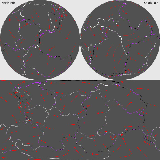
First, the planet’s plate tectonics, with the plate boundaries defined in white (for divergent boundaries), black (for convergent boundaries), and purple (for transform boundaries) and the directions of drift marked by red arrows, in Equirectangular Projection and Poles-Centered perspective.
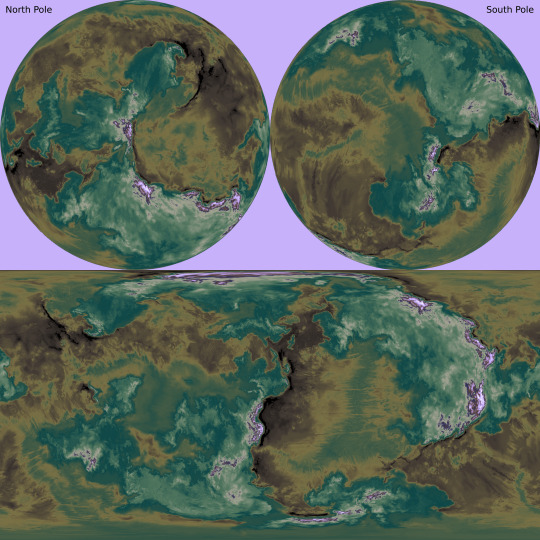
The maps below show the planet’s elevation data, first in grayscale with no color gradient applied, in Equirectangular Projection and Poles-Centered perspective;

then with the color gradient applied, also in Equirectangular Projection and Poles-Centered perspective;
and then with the color gradient once again removed but now showing the planet’s liquid water, in Equirectangular Projection only.

The second phase of this commission focused on the planet’s ice sheets and the liquid water hidden beneath it them.
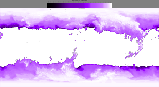
First, there’s the raw elevation data for the ice in relation to “sea level” -with no contiguous ocean to define this, it is instead defined as 200 meters above the average continental shelf’s edges, correlating to Earth’s own sea level-, along with a key, in Equirectangular Projection;

then, the same data with a color gradient applied;
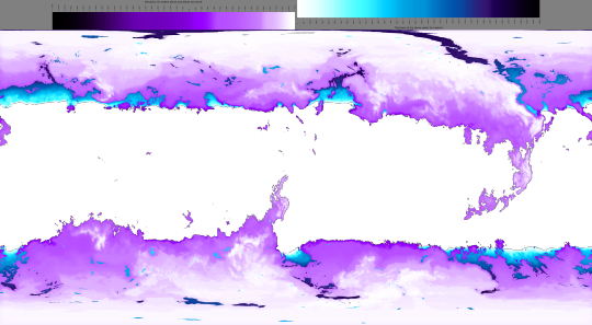
and again, this time also showing how many meters of ice sit atop the subglacial bodies of water;
and lastly, the thickness of the ice over land as well as water, first in grayscale;

and then with a color gradient applied.

The thickest point in Earth’s own ice sheets is 4,776 meters deep, just a fraction of the Bugferret planet’s maximum of 18,000 meters between the top of the ice sheet and the trench-sea hidden beneath it.
The map below shows the volcanic activity on this planet. Volcanoes marked in pink have erupted in the past millennium, and those marked in white have erupted in the past 300 years Looking back to the ice-cover map that also shows the subglacial water, you can see how some of those lakes are caused by recent eruptions, as are the few ice-free mountain peaks in the higher latitudes.

Lastly, the third phase of this project mapped out the cave systems, expanded tremendously both by modern Bugferret activity and previous eons of dissolution and upheaval by organisms more comparable to fungi, plants, and burrowing detritivores.
The first map below shows all of the major caverns combined into one layer, color-coded by vertical position in relation to the so-called sea level, instead of depth beneath the local surface.
I mapped out these caves in four overlapping layers, here color-coded to represent the tallness of a given chamber. The first of these layers contains those caves closest to the surface;

a bit further beneath the surface;

further down still;

and the lowest layer of all, with its shallowest caves sitting no less than 8,500 meters beneath their local surface.

All the caves shown here can be accessed from the surface, either directly or in connection to other caves, even if the connecting passages are too narrow to be visible at this resolution. Some of these connections can be fully seen or at least suggested in the cross section below, showing the vertical positions of the caverns beneath a mountain range, or a small slice thereof.

This cross section is shown again with a map that marks its location, and that also includes the ice sheets, subglacial and exposed liquid water, and combined caves.

These maps were all created in Photopea. My reddit post dedicated to this project, wherein you can see the highest resolution versions of these images, is linked here.
2022
#runaway to the stars#mapmaking#imaginary maps#worldbuilding#commission#digital painting#photopea#Bugferrets#fictional planets#elevation map#color gradients#ice maps#liquid water map#cave systems#major project#alien planet#Christopher Maida Artwork
62 notes
·
View notes
Text
cultures innovating on contact borders like oceanic divergent plate boundaries
58 notes
·
View notes
Text
The Mind Starts at Conception
Every abortion risks the creation of a bodily traumatized abortion survivor. The body remembers what our conscious mind does not record. It seems ridiculous to suggest to a survivor that what happened did not happen to them. Why?
Even if the body isn't harmed physically by an abortion, the stress still registers in the body-mind. You CAN stress out an embryo, literally. But then aren't epigenetics (inherited stress) part of a mind? I think so. That doesn't mean I think every cell with genes is a mind.
Gametes cease to exist upon fusion. They don't go through a stage of development; they become an entirely new thing. When their substances change there is a break in continuity between the gametes and the human minds to whom the gametes contribute genes and material. Meanwhile, a human organism doesn't cease to be at any point between fertilization and death, substantially or metaphysically.
A gamete not only ceases to be in physical substance at fertilization, (sperm in particular more or less dissolve,) but also metaphysically, in identity. For a lone gamete, the possibilities for which humans would inherit its DNA and material is an infinite set. It is unspecific. The zygote, on the other hand, is limited to about 4 potentialities. They are a specific, individual set. After the primitive streak, that set converges. Ergo, the set of a gamete is divergent, the set of a zygote is convergent.
"Markov blankets" is a theory related to the Free Energy Principle of Karl Friston that the mind is statistically boundaried to its most complete set. In other words, we can make a reasonable guess that a mind is definitely in some locations, not others.
I think we have good reason to suspect that the boundary lies somewhere between where the subsets of convergent series end (all the proprietary cells of the new person) and the divergent series begin (gametes). (We treat gamete cells more as 'your property' than as 'you'.) You could fairly speculate that the donor gamete MIGHT be in an individual's markov blanket. But if it is, it appears to be a statistical outlier. (One of these things is not like the other = outlier.) We're not unreasonable in saying gametes fall outside the line of best fit.
This shift from divergent series to convergent series seems like an extremely reasonable place to draw the metaphysical boundary of "I end and you begin". Like drawing the fault lines where two geological plates shift in different directions, but mereological! Of course, I could be wrong. If you can show me that the sets I am including pre-brain birth are meaningfully metaphysically different than the sets post-brain birth, then I'll reconsider my mereological stance. Perhaps the blanket is smaller than I think. But perhaps not.
When I ask myself, "which subsets of markov blankets act within this surprise-minimizing system" (a bare-bones definition of an individual mind,) I cannot say the donor gamete is clustered with the whole. On its own the gamete minimizes surprise in singularity, not individuality—individual, here referring to indivisible.
When I cut my hair, I don't look down and say "that's me on the floor". That hair isn't contributing to my system's perceptions in order to minimize surprise. I also wouldn't say that about my eggs if I froze them. They're divisible! But if you touch the living skin connected to my surprise-minimizing system, I'd say, "stop touching me". Not divisible. My zygote? Not divisible! Its perceptions are continuous with my system. If you tamper with a gamete, infinite individuals could inherit the effects. But once the tampered gamete fuses into a zygote, the effects are limited to an individual set of about 4 specific people. (4 because that's about how many times an embryo can bud a twin.)
An individual set of people in one blanket? You know what's cool about this?? This means up to about four people can exist as an individual set simultaneously in a single spatial and temporal location!! That's fucking neat. Yes, while these people's specific markov blankets will eventually diverge, they originate with convergent overlap. In this way, identical siblings can be said to LITERALLY share a mind, to some extent! Their markov blankets overlap!!
We cannot draw the boundary line for personhood based on substance, location, time, or ability alone. I'm drawing upon bayesian logic to make metaphysical inferences. Ergo, the pertinent question to me is not "is this a mind". Yes, I think my surprise-minimizing system, my sophisticated ability to think in predictions, is continuous with and contingent upon the rudimentary perceptive ability of my zygote.
The question is rather, why should you care? I think you should care about minds that are not like yours, but if all keeps going well, will be. I think you should care about minds that would be like yours, but all did not go well, so they are not. I think you should have unconditional regard for human minds in all forms.
17 notes
·
View notes
Text


New Ocean Forming in Africa
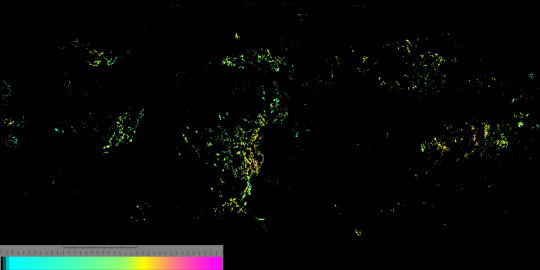
Recent research and satellite data have confirmed that Africa is splitting into two, resulting in the formation of a new ocean in the continent. This remarkable phenomenon is taking place in one of the driest and hottest deserts on Earth, the Afar desert, which spans across Ethiopia, Kenya, and Eritrea.
The genesis of this split and ocean formation can be traced back to a long rift that appeared in the Ethiopian deserts in 2005, following a volcanic eruption. Since then, the Afar desert has undergone a dramatic transformation, with fissures filled with cooled molten rock and a large crack formation appearing in the Kenyan Rift Valley in 2018.
While some Ethiopians have asserted the appearance of the rift in the deserts, many people around the world have questioned the possibility and cause of a continent tearing apart. However, science tells us that the formation of continents and oceans is a natural process that has been occurring for billions of years, driven by earthly collisions, volcanic eruptions, earthquakes, and other natural phenomena.
It is important to note that the ocean formation in Africa is not a result of environmental degradation induced by humans, but rather a natural cause. As we continue to study and understand this remarkable phenomenon, we can appreciate the incredible power and beauty of our planet and the natural processes that shape it.
The formation of the ocean that we witness today is a direct result of the powerful movements that occur within the Earth's crust. These movements cause the peeling of tectonic plates, which in turn allows material from deep within the Earth to rise to the surface and form oceanic crusts in the ridges.
According to the journal Geophysical Research Letters, the development of rifts is driven by processes similar to those found at the bottom of the ocean. The tectonic plates of Africa and Arabia have been gradually separating for about 30 million years, as they collide in the desert. This same motion has also split the Red Sea, but at a much slower rate of only a fraction of an inch per year.
Dr. Edwin Dindi, an expert at the Department of Geology in the Faculty of Science and Technology at the University of Nairobi, explains that the tectonic plates are in a constant state of flux, with some shifting against each other along fault zones, some falling beneath one another, and others crashing against each other, tearing apart at divergent plate boundaries. This motion has led to the formation of the various continents that we know today, including Africa, South America, North America, Europe, Asia, and Australia.
The continuous motion within the continental crust has also led to the formation of the East African Rift valley, which continues to widen and be active. This could potentially lead to the formation of a new ocean in Africa, although the future is uncertain.
The possibility of a new ocean forming in Africa is due to the fissures in the Afar desert that were filled with cooled molten rock after the 2005 volcanic eruption. These fissures are now developing, and it is likely that the Indian ocean will flood them, leading to the creation of a new ocean. The current movements and natural disasters, such as the 2023 cyclone Freddy and the 2022 cyclones Ana and Batsirai, are also contributing to the split.
Furthermore, the large crack formation that emerged in the Kenyan Rift Valley in 2018, despite originating from East Africa, continues to widen and remain active. This serves as evidence of the new ocean and the eventual split of the African continent.
The Rift, also known as the Afro-Arabian Rift Valley, is one of the most extensive rifts on Earth's surface. It stretches from Jordan in southwestern Asia, southward through eastern Africa to southern Africa, specifically Mozambique. It spans approximately 6,400 kilometers in length and averages between 48 to 64 kilometers in width.
According to Dr. James Hammond, a seismologist from the University of Bristol, some parts of the area lie below sea level, and the ocean is only blocked by a 20-meter block of land in Eritrea. However, the formation of the ocean in Africa could take millions of years. Dindi asserts that it has taken over 30 million years for the thickness around the rift valley to reduce from 40 kilometers to 35 kilometers. Therefore, it takes many years for just one kilometer to wear off.
It is a privilege to witness the development of this new discovery of a new ocean formation. However, this generation and possibly many more to come may not experience and live in a separated Africa. The future could regard this as a historical myth.
Biblically, the formation of the earth and the current formation of the ocean are scientific human knowledge based on research and studies. This is because no one today has lived millions of years ago. However, the theories are similar to the Biblical and other religious knowledge of God's creation of the earth.
#planet earth#eat her good#earth science#earth day#african history#geography#magazine#africa#panafrican#social media#my writing#african politics#afrique#art#afrofuturism#artists on tumblr#biblical#christian bible#bible in a year#bible shitpost#bibleversoftheday#bible devotions#science#scientifically proven#research scientist#scientific discovery#scientific american#scientific art#a certain scientific railgun#future
9 notes
·
View notes
Text
Plate Tectonics With Grain!
Nearly everyone knows the the earth is made of layers (like an onion, or an ogre) and that we live on the crust, the outermost layer. But very few people understand the magicly and wizardry behind the formation, destruction, and recreation of the crust.
So Let's Get Started :)
The earth's crust is composed of big funky dudes called plates. These are major slabs of rock that have well defined boundaries where they meet other slabs of rock.
These plates all like to push and shove against each other, and sometimes they gang up into cool lil creations called supercontinents.
but before we get to the cool fun epic stuff, two things must be established:
Plate types
Plate boundaries
First, plate types. There are two major types of plates:
continental
oceanic
Continental plates (more commonly called continental crust) are what make up continents and large landmasses. They are generally less dense than oceanic plates and are made mostly of the epic rocks you know as granite and andesite, with sedimentary sandy rocks on top.
Oceanic plates (or crust) are generally denser and made of darker, heavier rocks like basalt. Continental plates, because of their lower density, float higher than oceanic plates on the spicy mantle. this allows them to create landmasses where oceanic crust cannot.
Secondly, plate boundaries. There are three kinds of boundaries that can form where plates meet:
a convergent boundary
a divergent boundary
and a transform boundary
A convergent boundary is where two plates violently collide with each other, usually with one plate sliding under the other into the mantle, where it violently melts into molten magma lava rock. This causes the plate that is above to bunch up like when you ram two flatish slabs of clay into each other on a flat surface, forming mountains in the process. A great example of this type of boundary is on the American west coast, where the pacific plate subducts (goes under) the north american one. This is what drives the formation of the Rocky mountains that run north-south along the entire pacific coast, as well as what causes the increased geologic activity along that coast (earthquakes and volcanoes). Such boundaries tend to occur between continental and oceanic crust, because the oceanic crust usually goes down into the mantle because it's denser than the continental stuff. Funny enough, once it's sorta melted in the mantle it floats back up as granite and adds to the continental crust. Anyway, these also like to form big underwater trenches where the seafloor subducts and is why the Mariana Trench exists.
A diverging boundary is the exact opposite, where two plates are sliding apart under pressure from the mantle, where fresh magma pours out and cools into freshly baked igneous rock seafloor. This is (to my knowledge, feel free to fact check) what causes phenomena like the east african rift valley and mid-atlantic ridge. Generally such divergent zones will have a trench or a ridge along the fault line and can be some of the places where the crust is the thinnest on earth. The diverging plates will push other plates in turn, and cause the formation of convergent boundaries. due to the rising hot stuff (spicy rocks) from where the plates are pulling apart, new oceanic crust is usually formed because the fresh magma pours out from below.
The final type of boundary is a transform line (not related to the geometric function of taking a shape and moving it to a different space on a coordinate plane), which is responsible for most silly little majorly devastating tiny little silly earthquakes like the very recent one in Turkey. Such boundaries are places where crust is not created (like in divergent boundaries) or destroyed (in convergent boundaries). Instead, plates slide past each other in opposite directions. Structures built on top of such a boundary would slowly split down the line, as one side is dragged in one direction and the other is carried in the opposite direction. One of the most well-known examples of such a boundary is the San Andreas fault line, off the coast of California.
With the types of boundaries covered, it's now very very important to understand how oceanic and continental crusts are created. Oceanic crust is formed at divergent boundaries, where new magma can rise up and solidify into the igneous rocks that form the seafloor. these rocks are then slowly pushed towards continental plates, which subduct them back into the mantle to be melted again. This time around, they are pushed up into the continental crust and cool there, turning into granite and other metamorphic rocks. This is then weathered down back into sand and sent into the ocean or plains, where eventually it might find itself as a sedimentary rock until it can be carried all the way back to the mantle.
As for how continents move and collide, it actually relies on the same force that creates the ocean currents and jet streams. like boats on a strong current, the plates move based on the convective motion of the mantle. They rely on the coriolis effect, convection, and even the gravitational pull of the sun and moon to move as well as pressure from the new seafloor at divergent boundaries, and they essentially act as a giant jigsaw puzzle of stones and spicy rocks. The movement of magma within the mantle carries the plates around, and they can then crash into, slide past, or move away from each other. Below is a helpful diagram:

Plate tectonics are visible nearly everywhere you go, in the coastlines of continents to the mountains you might aspire to climb. A lot of geology relies on plate tectonics turning up old rock layers like they have in the massive formations of rocky mountain national park or in the east African rift valley, where much of human evolution can be found in the fossil record.
The East African Rift Valley, which is the result of diverging continental plates
The Pacific Ring Of Fire, which is the result of converging plates
The Himalaya Mountains, the result of converging plates
The Rocky Mountains, see above
The Andes Mountains, see above
The Atlas mountains, see above
The Alps, see above
The Mediterranean, same(ish) reason as the alps, just with the caveat of being formed by the drifting of the African plate closing in the Arabian peninsula through the oligocene and miocene periods.
The Japanese archipelago, again from plate subduction (pacific ring of fire)
Fun fact actually, what happened with the Himalayan Mountains is pretty unique when it comes to plate tectonics, since they weren't formed by subduction or divergence. See, they were formed by the Indian and Asian plates colliding some 40 million years ago, but both plates had more or less the same density. This means that neither could subduct into the mantle, so instead they both began to buckle and crush the stone upwards, forming what is now the Himalayas. This is unique in that both plates began to form mountains instead of only one, and that the Himalayas are now the tallest mountains on the planet because these two massive plates came together when they did.
Final note, the Hawai’ian islands as well as a few other are not formed along plate boundaries. They are formed through a different phenomenon called Hotspots. This is when a jet of ridiculously hot magma is shot up through the seafloor and ocean to make new islands. the plate then moves while the hotspot stays in the sameish spot, so the islands are formed in a line that follows the movement of the plate. This is what happened with the hawai’ian islands and probably a few others that I dont know about.
For further reading on plate tectonics check out the US National Oceanic and Atmospheric Administration(NOAA) and the US National Park Service (NPS) resources, as well as the wikipedia page if you want an in depth summary that goes into a lot more detail than me.
#geology#rant#long post#yes i am autistic how did you know#plate tectonics#science#new thingy'#learn something new#you cna do it learn something new#read hte psot and learn something enw cmon#its rlly lat egod why did i do this
7 notes
·
View notes
Text
Divergent boundary, also known as a constructive boundary or an extensional boundary, is a linear geologic feature that exists between two tectonic plates that are moving away from each other.
12 notes
·
View notes
Text
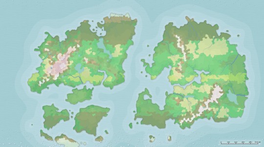
Worldbuilding Journal
Project Alora Update #1
Origin
Solar system
Continents
It seems fitting to begin our journey at the very beginning when the worlds came into being. I wanted to establish a blend of science and magic very early on, as this will be used in a D&D campaign(s), so I began piecing together a creation story based on a magic version of the Big Bang and more science based cosmos.
The Great Abyss - In the beginning, the first Eternal being beyond time and matter was the Mother Nov’ya. She suffered millennia alone until she carved into the inky darkness with her sickle and pulled matter from the abyss she created. From this matter, beings similar to her began to emerge and shape the cosmos into being.
Essentially this creates a trickle down of celestial beings and bodies filling the cosmos with life and magic. It also sets up an original “pantheon” that goes further than the specific world this campaign will be working out of while also allowing other DMs to use the setting for more than just your standard fantasy dnd campaign.
From there, I worked out the base idea of how this planet world come to be using a couple different resources. Generating a map using Azgaar’s Fantasy Map Generator, I got a general starting point for how this world was going to shape up. From there, I input some planetary data to get realistic data to base the planet Alora on. (Linked below) This gave me the data I needed to work out the habitability of the planet, biomes, water composition, number of suns and moons, etc.
Planet Alora of the Silarius Spiral Galaxy is the closest of 4 planetary bodies nestled around the 2 Suns: Faebon (yellow/white) and Kua (yellow/orange). Alora’s companion planets are Vigil (Gas Giant), Frygd (Ice Terrestrial), and Solus (Ice Gas Dwarf). She also has 2 moons orbiting her, Siva (grey/white) and Azra (blue).
Now that the number bit was out of the way, I moved on to tectonic plates to solidify the shape of the continents. This was more like piecing together a puzzle than anything. Having the generated map to work off of, I simply overlayed some shapes with the idea of how they would react to each other. This helped me flesh out which areas would have mountains or valleys and have a story to how the continents moved from a Pangea formation to what it would be like in the campaigns current day, setting the foundation for cultures, flora, and fauna.
Alora has 2 main continents and an island group. The 2 continents are separated by a divergent boundary on one side and a convergent boundary on the other, slowly driving the two further apart. The islands sit on a series of smaller plates slowly converging with the smaller continent on the left.
I'll have the next update tagged under #projectalora! Up next is Cultures, Religions, and Countries ~
Resources:
#dnd#dnd worldbuilding#worldbuilding#dm#dnd5e#gm#worldbuilding journey#project alora#fantasy worldbuilding#worldbuilding journal
6 notes
·
View notes
Note
I must ask all the scientists and bookworms in any of the AU’s, is the ocean soup? -🐹 I love Xavier!!!
Ahh I'm confused if this is a question for my ocs lol so I'll answer it like that! Imma answer as Jedrek since he's my main scientist character!
Jedrek: Um. Huh I never really given that much thought. If we're referring to the commonly accepted definition of the term "soup" which is, and I'm quoting this from an online source "a liquid dish, typically made by boiling meat, fish, or vegetables, etc., in stock or water" Id have to say no. An ocean as a whole is not hot enough to be considered soup. But there are areas in the ocean called Hydrothermal vents that usually occur on divergent plate boundaries, which are areas of tectonic plates that are moving away from each other. Those Hydrothermal vents are extremely hot so you could consider those areas boiling. However the organisms that live near those vents wouldn't be boiled alive since they've adapted to those areas. Unless you throw a bunch of boiled fish and broth into the whole ocean, than it is definitely not a soup.
(Ahh I hope I did my best to sound smart! Thank god for google I'm I right? I'm glad you like Xavier! I plan on redesigning him soon! We'll as soon as I can start drawing again. I'm gonna try cause I really miss it)
2 notes
·
View notes
Last Seen Blogs