#Cyclades Island Group
Explore tagged Tumblr posts
Text

Naxos, Cyclades Island Group, Greece
3 notes
·
View notes
Text
Prehistoric Figurine of a Harp Player, from the Cyclades (Greece), c. 2700-2300 BCE: this figurine was shaped from a block of solid marble and then slowly sanded into form using pumice and emery
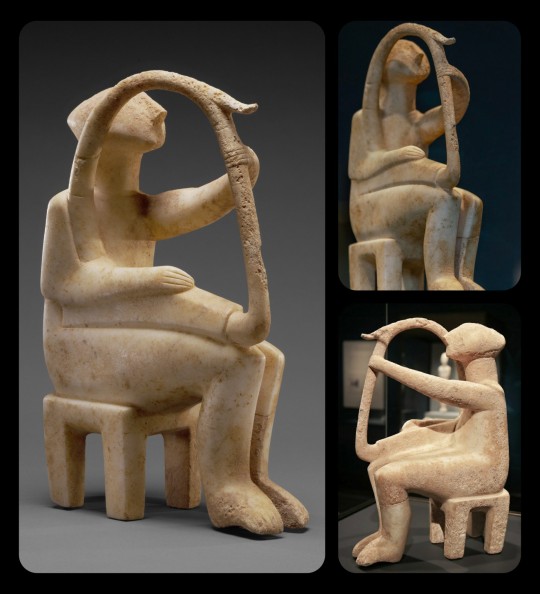
The figurine depicts a musician with a frame harp, an instrument that originated in the Near East and then later spread to the peoples of the Aegean. A sound box forms the section along the base of the instrument, and a small protrusion can be seen near the top of the harp's frame; some experts have argued that this protrusion might represent an ornamental carving of a waterfowl's head, while others argue that it represents a musical extension that facilitates the projection of sound (a feature that often appears on the stringed instruments of the ancient Near East).
This piece measures 35.8cm (about 14 inches) tall.
Musical performances like this are rarely depicted in Cycladic artwork. Depictions of male characters are similarly rare, representing only 5% of the Cycladic sculptures that are known to exist. When male figures are depicted, however, they are frequently shown playing musical instruments, as seen here.
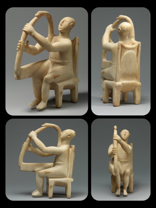
Figurine of a Harpist, c. 2800-2700 BCE: a similar example of a Cycladic sculpture that features a musician with a frame harp
The Museum of Cycladic Art provides a more detailed explanation of the process by which these figures were created:
As we can deduce from the few unfinished figurines that have been discovered so far, the first step in the process was to roughly shape the raw piece of marble into a figure by the impact of a mallet. Emery powder was then used to abrade the surface until it obtained the desired shape and size. Once the desired shape was achieved, the surface was smoothed carefully before the fine work of carving the details started. At the end, the figurine was polished to a high degree that is still amazing.
And according to The Met:
Many of these figures, especially those of the Spedos type, display a remarkable consistency in form and proportion that suggests they were planned with a compass. Scientific analysis has shown that the surface of the marble was painted with mineral-based pigments—azurite for blue and iron ores, or cinnabar for red.
The Cycladic Islands (also known as the Cyclades) are a group of about 30 separate islands in the Southwest Aegean, off the coast of mainland Greece. These islands contain a wealth of natural resources, including marble, emery, pumice, obsidian, and an assortment of precious metals. The prehistoric peoples of the Cyclades made use of these resources for many different purposes, but the marble figurines/sculptures that they crafted during the Bronze Age are perhaps their most famous creation.
The vast majority of these figurines are stylized depictions of the female form. The cultural significance of the sculptures remains unclear; they may have simply been created as decorative pieces/artwork, without any additional function, or they may have been used as fetishes, totems, religious idols, grave goods, or votive offerings.
Sources & More Info:
The Getty Museum: Figurine of a Harp Player
The Met: Cycladic Harp Player
The Met: Early Cycladic Art and Culture
The Museum of Cycladic Art: Techniques
#archaeology#history#artifact#ancient history#prehistoric art#art#sculpture#music#greece#cycladic#bronze age#anthropology#harp
1K notes
·
View notes
Text

Santorini, Greece: Santorini is a Greek island in the southern Aegean Sea, about 200 km southeast from its mainland. It is the largest island of a small, circular archipelago formed by the Santorini caldera. It is the southernmost member of the Cyclades group of islands, with an area of approximately 73 km2. Wikipedia
139 notes
·
View notes
Photo

Linear A Script
Linear A Script was used by the Minoan civilization centred on Crete during the Bronze Age. Used from around 1850 to around 1450 BCE, the script has never been deciphered. Artefacts bearing Linear A script, most commonly clay tablets, have been found across the Mediterranean, evidence that Minoan trade was conducted with such islands as Rhodes, Thera, and the Cyclades.
Origins & Development
Linear A script is one of a group of written languages that linguists identify as related syllabic scripts used during the Bronze Age in the Aegean and the wider Mediterranean. The oldest identified script in Europe is the Cretan Hieroglyphic script, which was in use from around 2000 to 1650 BCE. This script, which uses pictures to denote objects and later representative sounds, remains undeciphered. Linear A, perhaps arriving a little later (the point is still under debate by historians), was prevalent from around 1850 to 1450 BCE and has also never been deciphered. At the early Minoan palaces, Cretan Hieroglyphic and Linear A script were used simultaneously for a period. There is a clear (but not absolute divide) in terms of artefacts bearing Cretan Hieroglyphic script and Linear A script, with the former appearing more in the north of Crete and the latter more in the south. Linear A script was being used across the whole of the island by the late 16th century BCE.
Linear A script is composed of at least 90 characters, which can be grouped into syllabic signs, ideograms, and symbols which denote numbers and fractions. In addition, monograms were made from the clustering of two or three symbols. The historian H. Thomas suggests that there are over 800 words identifiable in Linear A script. The famed Greek historian S. Alexiou gives the following description of the script:
This script is termed Linear because it is made up of signs which, although derived from ideograms, are no longer recognizable as representations of objects, but consists of lines grouped in abstract formations. (127)
The later Linear B script of the Mycenaean civilization was developed from Linear A (about 70% of Linear A symbols appear in Linear B) and was used to express the language we today call Mycenaean Greek (deciphered in 1952 CE). Linear A script, then, is an important indicator of a continuing though changing culture in the ancient Aegean.
Continue reading...
107 notes
·
View notes
Photo

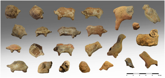


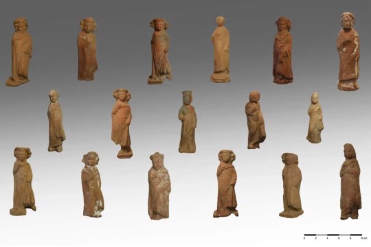
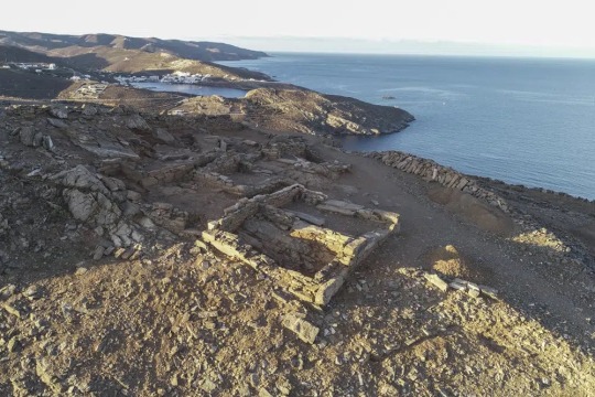
Greek Temple Complex Reveals Thousands of Votive Figurines
Archaeologists excavating a hilltop sanctuary on the Aegean Sea island of Kythnos have discovered “countless” pottery offerings left by ancient worshippers over the centuries, Greece’s Culture Ministry said Wednesday.
A ministry statement said the finds from work this year included more than 2,000 intact or almost complete clay figurines, mostly of women and children but also some of male actors, as well as of tortoises, lions, pigs and birds.
Several ceremonial pottery vessels that were unearthed are linked with the worship of Demeter, the ancient Greek goddess of agriculture, and her daughter Persephone, to whom the excavated sanctuary complex was dedicated.
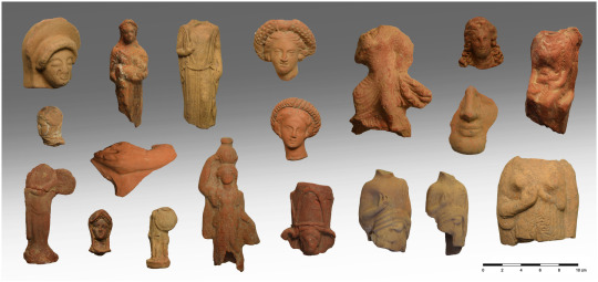
The seaside site of Vryokastro on Kythnos was the ancient capital of the island, inhabited without break between the 12th century B.C. and the 7th A.D., when it was abandoned for a stronger position during a period of pirate raids.
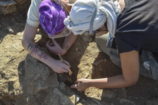
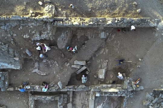
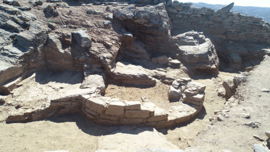
The artifacts came from the scant ruins of the two small temples, a long building close by that may have served as a temple storeroom and a nearby pit where older offerings were buried to make space for new ones. The sanctuary was in use for about a thousand years, starting from the 7th century B.C.


The excavation by Greece’s University of Thessaly and the Culture Ministry also found luxury pottery imported from other parts of Greece, ornate lamps and fragments of ritual vases used in the worship of Demeter and Persephone at Eleusis, an ancient Athens suburb.
It is unclear to what extent the site on Kythnos was associated with Eleusis — one of the most important religious centers in ancient Greece, where the goddesses were worshipped during secret rites that were only open to initiates forbidden to speak of what they saw. The sanctuary at Eleusis is known to have owned land on the island.
Kythnos, in the Cyclades island group, was first inhabited about 10,000 years ago. Its copper deposits were mined from the 3rd millennium B.C., and in Roman times it was a place of political exile.
The excavations are set to continue through 2025.
#Greek Temple Complex Reveals Thousands of Votive Figurines#island of kythnos#pottery#pottery offerings#ancient artifacts#archeology#archeolgst#history#history news#ancient history#ancient culture#ancient civilizations#ancient greece#greek history#greek art#long reads
531 notes
·
View notes
Text
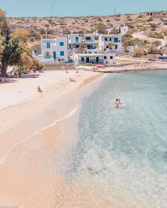
This is the tiny island of 📍iraklia (Ηρακλειά) - @cyclades-islands ❤️
It belongs to the small cyclades islands group!
Calm atmosphere away from mass tourism makes it ideal for relaxing!!
Pic by: https://www.instagram.com/p/Cs4HPVuMGS_/?igshid=MzRlODBiNWFlZA==
#cyclades#greece#travel#summer#cyclades_islands#κυκλαδες#ελλαδα#aegeansea#visitgreece#greeksummer#small cyclades#iraklia#iraklia cyclades#Cyclades greece#explore cyclades#explore greece
93 notes
·
View notes
Photo

Mykonos is an island in the Cyclades group in the Aegean Sea.
132 notes
·
View notes
Text
📍Naxos island,Greece 🇬🇷
The biggest and most fertile island in the Cyclades group, located right in the centre of it. According to the Greek Myth, god Dionysus met Ariadne, the Minoan princess, on Naxos Island, where she was abandoned by Theseus, the Athenian prince, during his return voyage from Crete to Athens.
Καλημέρα Ελλάδα μου!!
2 notes
·
View notes
Text

Oia village is built along the rim of the massive volcanic caldera of Santorini Island, southernmost of the Cyclades island group, Greece.
2 notes
·
View notes
Text

Painted blue door with climbing plants, flower mural and yellow watering can. Lagada,
Amorgos, Greece.
Amorgos is a tiny island in the Cyclades Greek island group with only about 2000 residents. It measures only 48 square miles, but it seems as if every square inch is packed with outstanding beauty.
2 notes
·
View notes
Text
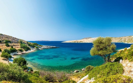


Look no further if you're seeking a serene escape from the bustling crowds. I've got a list of the five smallest Greek islands you can visit.
1. Kastellorizo (Megisti) Nestled in the southeastern Mediterranean, Kastellorizo is a colourful and vibrant island perfect for a relaxing getaway. This Dodecanese gem is only 9 km², but it's filled with charm. Stroll through its picturesque harbour, dive into crystal-clear waters, and admire the unique architecture. Don't forget to visit the Blue Grotto, one of the most spectacular caves in Greece.
2. Halki Located just 6 km off the coast of Rhodes, Halki is an enchanting island perfect for a peaceful retreat. Measuring only 28 km², Halki offers pristine beaches and charming traditional villages. Make sure to wander through the colourful streets of Nimporio, the island's main village, and take in the stunning views of the Aegean Sea from the hilltop Chorio.
3. Agathonisi With an area of 13.5 km², Agathonisi is the northernmost island of the Dodecanese group. This tranquil paradise offers unspoiled nature, crystal-clear waters, and traditional Greek hospitality. Visit the quaint villages of Megalo Chorio and Mikro Chorio, and unwind on its secluded beaches.
4. Paxos Lying just south of Corfu, Paxos is a lush, verdant island covering an area of 30 km². Famous for its stunning blue caves, it's an ideal destination for snorkelling and diving enthusiasts. Explore the charming villages of Gaios, Lakka, and Loggos, and indulge in delicious local cuisine. Take a boat trip to the nearby Antipaxos island for an unforgettable beach experience.
5. Anafi is an idyllic Cycladic island, and is a true hidden gem covering just 38 km². Discover its unspoiled sandy beaches, hike to the ancient Temple of Apollo, and enjoy breathtaking sunsets at the island's highest point, Mount Kalamos.
#goexploregreece#goexplore#exploremore#exploregreece#exploretheworld#explore#greecestagram#greecetravel#greece#travel tips#traveling#traveller#travelling#travel#traveltips#corfu#paxos#anafi#aegean#dodecanese#beaches#mustvisit#must visit#must see#mustsee#greek islands
13 notes
·
View notes
Text


Santorini, Cyclades Island Group, Greece
2 notes
·
View notes
Text
#day cruise Mykonos#sunset cruise Mykonos#Mykonos Yacht Charter#private cruise Mykonos#Mykonos beaches#Psarou beach#Paraga beach#Kalafatis beach#Mykonos
8 notes
·
View notes
Photo
Orange Santorini views
Santorini
Island in the Aegean Sea
Santorini is one of the Cyclades islands in the Aegean Sea. It was devastated by a volcanic eruption in the 16th century BC, forever shaping its rugged landscape. The whitewashed, cubiform houses of its 2 principal towns, Fira and Oia, cling to cliffs above an underwater caldera (crater). They overlook the sea, small islands to the west and beaches made up of black, red and white lava pebbles.
Administrative region: South Aegean
Area code(s): 22860
Postal code: 847 00, 847 02
Regional unit: Thira
Santorini is an island in the southern Aegean Sea, about 200 km (120 mi) southeast from the Greek mainland. It is the largest island of a small circular archipelago, which bears the same name and is the remnant of a caldera. It forms the southernmost member of the Cyclades group of islands, with an area of approximately 73 km2 (28 sq mi) and a 2011 census population of 15,550. The municipality of Santorini includes the inhabited islands of Santorini and Therasia, as well as the uninhabited islands of Nea Kameni, Palaia Kameni, Aspronisi and Christiana. The total land area is 90.623 km2 (34.990 sq mi). Santorini is part of the Thira regional unit.


Firá is the modern capital of the GreekAegean island of Santorini (Thera). A traditional settlement, "Firá" derives its name from an alternative pronunciation of "Thíra", the ancient name of the island itself.

Oia is a small village and former community in the South Aegean on the islands of Thira (Santorini) and Therasia, in the Cyclades, Greece.

Nea Kameni is a small uninhabited Greek island of volcanic origin located in the Aegean Sea, within the flooded Santorini caldera.

Santorini ancient Thera, view from Mount Elias
Ancient Thera is the name of an ancient perfectly round volcano island now known as Santorini. It was named after the mythical ruler of the island, Theras..
It is the most active volcanic centre in the South Aegean Volcanic Arc, though what remains today is chiefly a water-filled caldera
Santorini - Wikipedia

6K notes
·
View notes
Photo
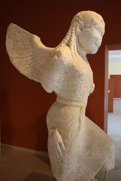
Paros
Paros is an island in the Cyclades group in the central Aegean. It is the third largest island of the Cyclades and its position on important sea routes between mainland Greece and the coast of Asia Minor made it an important centre from the early Bronze Age through to Roman times. The island was also famous for the high quality of its marble which became a popular material for sculptors and architects throughout antiquity.
Bronze Age Paros
First inhabited from c. 3200 BCE (or perhaps even earlier), important settlements from the Early Cycladic Period include those at Drios, Avyssos, Galana, Gremna, Kampos, and Plastiras. The relatively high level of culture in the early Bronze Age is attested by the wealth of decorated pottery finds and in Cycladic sculpture which produced elegant marble figures rendered in a minimalistic style.
At the island's capital Parikia (Paroikia) on the west coast the first indications of settlement date to the early 2nd millennium BCE and the area was continuously occupied through Minoan and Mycenaean times and settled by colonists from Attica c. 1000 BCE being occupied until around 700 BCE. On the north coast at Naoussa there was a major Mycenaean settlement which prospered in the 13th century BCE but was destroyed in c. 1200 BCE. Nevertheless, the site was reoccupied from the 10th century BCE and once again enjoyed a period of prosperity from the 9th to the mid-7th century BCE. Koukounaries on the east coast was also an important Mycenaean centre in the 13th and 12th centuries BCE and continued into the mid-7th century BCE. It was here at Koukounaries that the oldest temple on the island was built, the temple to Athena dating to c. 700 BCE and which survived into Classical times.
Continue reading...
59 notes
·
View notes
Text
0 notes