#Caldor Fire
Explore tagged Tumblr posts
Visit Tumblr Blog
Explore Tumblr blogs with no restrictions, modern design and the best experience.
Last Seen Tumblr Blogs


Fun Fact
Tumblr Inc. has $15.1M in annual revenue.
Text
Writing Patterns
rules: Share the first line of your last ten published works or as many as you are able and see if there are any patterns!
I was tagged by @roughlytwentytwofrogs
1. Fire Falling from the Sky (Baldur's Gate 3)
“Vlaakith gha’g shkath zai!” The warrior snarled as Shadowheart parried his blade, the polished steel glinting in the dim light before the githyanki gurgles and collapses, bloodied blade sliding out of the warrior as he slumps over, Caldor grimacing with concentration; having come up behind the alien warrior to strike the fatal blow.
2. Vyper's Mask (Original Sapphic BDSM Romance)
Synport.
3. Favored Princess (Baldur's Gate 3)
What the hell was she thinking?!
4. I Am the One (Dragon Age: Origins)
The world slowly came back into focus, ears ringing and the back of her head throbbing painfully from where it had smacked the stone floor.
5. Wrong Turn at Faerun (Baldur's Gate 3)
The Moonsilver Solstice was Kalach’s favorite holiday.
6. Kiss Me Until You're Drunk (Baldur's Gate 3)
Shadowheart woke in a cold sweat, her right hand seized up and clawed in pain as the black scar on the back of her right hand weeps black ichor.
7. Descend Beyond Avernus (Baldur's Gate 3)
Two Months Prior…
8. A Questionable Use of Dominate Person (Baldur's Gate 3)
“You want to… what?” Hestra retorts, not sure she heard her githyanki paramour correctly.
9. Tear up the Town (Love, Death, Robots)
Sonnie looked at the bottle in her hand.
10. Possessive (Baldur's Gate 3)
The victory tastes like ash in Shadowheart’s mouth.
Hmm, the pattern seems like a favor my 'hook' to focus on the main protagonist in some manner... or at least one of them, if there's multiple. It seems to, always, happen in the middle of an event, action, thought, etc.
What do you guys think?
Also check out the fics, cause why not? they're there.
Also gonna tag @larissel @robeca-black @dilutedpilk & @cobalt-cactus... cause this was kinda fun to do.
#check the tags before you read#I write a lot of smut#ao3 writer#ao3 link#I like these kinda interactions gimme more#I apparently make up 1% of the Shad'zel fics on AO3#I also make up 1% of the Lae'Tav fics on AO3#I never planned on being a writer but here we are
4 notes
·
View notes
Text
Junkshow Media House - Season 11
(Written by The Crew - December 19, 2023)
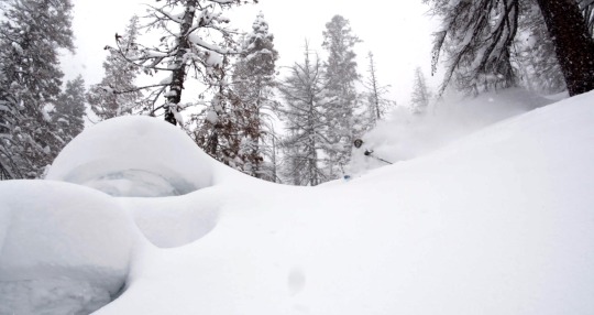
Junkshow Media House is back with their 11th season. The first installment of the year features Josh Daiek and Stan Rey, crushing the Tahoe backyard during the depths of a storm. Enjoy.


In the spirit of keeping shit simple, we batched the episodes into one post - Episode 2, Ring The Bell is full of spines, lines and some fucking good times.

4 notes
·
View notes
Photo

CAMPout is a minimal residence located in Truckee, California, designed by Faulkner Architects with Nicole Hollis. As wildfires continue to ravage the West Coast, architects are increasingly taking into consideration the threat of fire in their designs. One such project is a family home near Lake Tahoe in the Sierra Nevada range, which was built with fire-resistant materials and a protective posture in response to the Caldor Fire that came within 25 miles of the location in 2021, destroying over a thousand structures
15 notes
·
View notes
Text
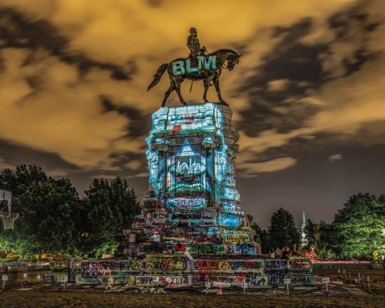
One month after George Floyd was murdered while in police custody in Minnesota, Kris Graves photographed the remnants of the Confederacy in and around Richmond, Virginia. “One late night on statue-lined Monument Avenue, I came across projections by artist Dustin Klein on the monument of Robert E. Lee,” he writes. “We stood and watched a seemingly endless rotation of Black lives that had been ended at the hands of police.” Officer Derek Chauvin was convicted of Floyd’s murder one year later, but Graves writes that “this continues to be an epidemic in the United States.” Photograph By Kris Graves, National Geographic

Wildlife ranger Joseph Wachira comforts Sudan, the last living male northern white rhino, as he laid dying at the Ol Pejeta Conservancy in Kenya in March 2018. “He died surrounded by people who loved him,” wrote Ami Vitale, who was there to capture his last goodbyes. She added that she hoped that Sudan's legacy “will awaken us to protect this magnificent and fragile planet.” Photograph By Ami Vitale, National Geographic
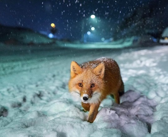
While documenting the treacherous waters and fishing culture of the Aleutian Islands, photographer and salmon fisherman Corey Arnold captured this image. “Every night in Unalaska, I'd spot this red fox near the side of the road, charming drivers with its irresistible cuteness into throwing it snacks out the window,” he writes. “On this evening, I spent a few hours watching this fox at work, using my headlights to light the scene.” Photograph By Corey Arnold, National Geographic
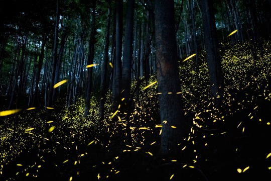
“I don’t know about you, but fireflies take me back to childhood,” writes Kiliii Yuyan, who captured these synchronous fireflies flashing at early nighttime in the forests of the Great Smoky Mountains National Park. “Here, in the space all around me, a thousand tiny green-yellow lights are miniature lanterns, blazing long enough to be seen but always escaping my cupped hands.” Photograph By Kiliii Yuyan, National Geographic

This is a rare example of performing polar bears, a controversial but not illegal practice in Kazan, Russia. Polar bears are a threatened species and a powerful symbol for conservation—yet these bears are fitted with metal muzzles and their trainer holds a metal rod. Photographer Kristen Luce and writer Natasha Daly traveled the world to learn about the suffering behind the scenes of wildlife tourism. “Our intention is not to shame tourists who have had these encounters,” Luce writes, “but to arm our readers with information that will help them identify potentially abusive situations for animals.” Photograph By Kristen Luce, National Geographic

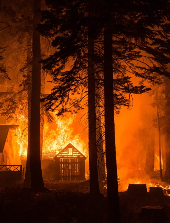
Left: “A reminder to breathe,” writes photographer, filmmaker, and mountaineer Jimmy Chin of this striking image of the Middle Teton in Grand Teton National Park. Photograph By Jimmy Chin. Right: The Caldor Fire rips through a valley south of Lake Tahoe on August 29, 2021. Lynsey Addario documented the California wildfire season—the second worst on record—on assignment for National Geographic. Photograph By Lynsey Addario National Geographic
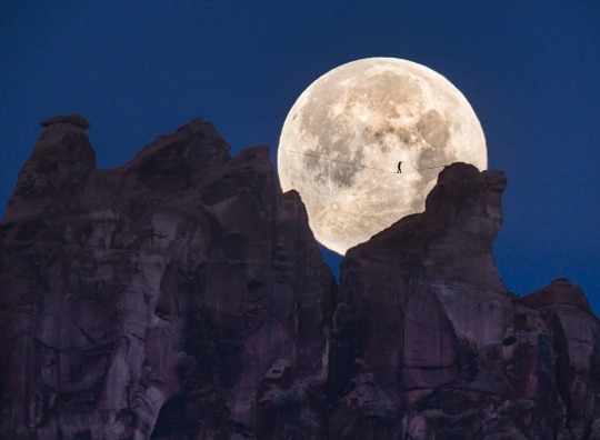
Andy Lewis crosses a slackline high above the valley floor in Moab, Utah. Photographer Renan Ozturk dedicated this photograph to his late friend Dean Potter, who first envisioned a free-solo image like this "moon walk," captured without digital manipulation within a single frame. After missing his first chance at the shot, Ozturk writes that he “stumbled through the night, arriving tired and bloody to the moonset/sunrise location on the opposite side of the towers.” Photograph By Renan Ozturk, National Geographic
3 notes
·
View notes
Text
https://www.mercurynews.com/2022/11/04/more-bay-area-rain-is-expected-this-weekend-could-it-bring-an-end-to-fire-season/
According to Cal Fire, crews have battled 7,211 wildfires in the state this year that have burned 362,351 acres, caused nine deaths, and destroyed 876 structures. The worst of those were the Mosquito Fire in Placer and El Dorado counties (76,788 acres, 78 structures destroyed, two firefighters injured) and the McKinney Fire in Siskiyou County (60,138 acres, 185 structures, four deaths, seven injuries).
In 2021, a far worse year, wildfires in California burned 2.57 million acres and destroyed 3,846 structures, according to Cal Fire records. The Dixie Fire in Butte, Plumas, Lassen, Shasta, and Tehama counties burned nearly 1 million acres. Five other fires cut through huge swaths of vegetation: The Monument Fire in the Shasta-Trinity National Forest (223,124 acres); the Caldor Fire in El Dorado County (221,835); the River Complex in the Klamath National Forest (199,359); the McFarland Fire in Trinity, Shasta and Tehama counties (122,653), and the Beckwourth Complex in the Plumas National Forest (105,670).
And 2020 was even worse: fires burned 4.3 million acres in the state, killing 33 people and destroying 11,116 buildings, according to Cal Fire records. Cal Fire crews battled 8,648 wildfires that year.
1 note
·
View note
Text
How Do We Deal With Our Planet's Unprecedented Decline?
September 14, 2023 Throughout the world, scary “natural” fire, flood, and heat records were set this summer season. Flames from the Caldor Fire crown in trees at Echo Lake, Calif., in August 2021. (Carlos Avila Gonzalez/ San Francisco Chronicle by means of Getty Images) This short article initially appeared at TomDispatch.comTo remain on top of essential short articles like these, register to…

View On WordPress
0 notes
Photo


Watching it burn
435 notes
·
View notes
Text
Flee for Your Life? Wildfires transform hiking in California's mountains
This is an excerpt from an article published on August 21, 2022 in the Santa Cruz Sentinel. I wish so many of our posts were not related to wildfires but fires have become a critical issue in trip planning and trip safety. Make sure you read to the recommendations at the end of the piece.
By Ethan Baron
Andrew Schrock woke around midnight smelling smoke on a backpacking trip late last month in California’s far north.
“I heard what I thought was rain but was ashes on the tent,” said Schrock, 43.
Using a satellite-based device from the Klamath National Forest near the Oregon border, he texted family and friends back home to find out what was happening – but “no one was up.”
He’d had cell service a mile back along the iconic Pacific Crest Trail that stretches from Mexico to Canada, so he set out alone in the dark, got online, and discovered that the McKinney Fire – which has since grown to more than 60,000 acres, killed four people and required the rescue of 60 hikers from the California side of the trail – had ignited behind him to the south the previous afternoon.
Ask anyone who hikes in California’s mountains about wildfires and you’ll likely get an earful about canceled trips, detours, lung-burning smoke and, possibly, harrowing escapes. Backcountry travelers are increasingly finding themselves on the dangerous edge of a changing climate that is driving drought, parching forests, spreading tree-killing beetles and altering weather patterns. Add in heavy vegetation buildup from decades of fire suppression, and you have frequent, ferocious forest fires that scramble hikers’ best-laid plans and demand new tactics for staying safe.
Schrock, of Long Beach, flew from Ashland, Oregon, to Fresno and then caught a bus to Yosemite to get back into the Sierra Nevada and finish his vacation covering more ground and enjoying the wilderness on his multi-year quest to complete the Pacific Crest Trail, he recalled while taking a snack break beside Lower Echo Lake near Lake Tahoe.
Dallan Clancy of Belmont, 68, finishing up a day hike 100 miles west of Sacramento at Carson Pass, said he had to cancel an overnight trip last September in the southern Sierra because the U.S. Forest Service shut access to all but one of California’s national forests over fire risks, including what the agency called “fire behavior that is beyond the norm of our experience and models such as large, quick runs in the night.” Clancy said he and four friends are aiming to do the trip this year, “unless it gets really bad.”
“We’ve always made note of escape routes, but on this trip, we actually planned our escape routes. We wanted to know the routes we could take to get out to a road,” said Jack Daro, a Southern California musician taking a break at Carson Pass during a backpacking trek to Yosemite National Park.

Hikers in years past “just went and did whatever you wanted to do wherever you wanted to go,” Wilkinson said. But 2020 marked a transformation, with the million-acre August Complex Fire, the Creek Fire northeast of Fresno that led to helicopter evacuations of hundreds of people including hikers on the John Muir Trail, and other massive blazes launching California into the age of mega-fires, Wilkinson said.
Nine of California’s 20 biggest fires since 1932 have occurred in the past three years, torching 4.1 million acres, according to Cal Fire. This year’s five biggest blazes have burned 116,000 acres, and “we’re just now getting into peak wildfire season,” Wilkinson said.
U.S. Forest Service spokeswoman Adrienne Freeman noted that fire can move much faster in today’s baked-crisp forests. “The window between OK and not OK,” Freeman said, “is becoming shorter and shorter.”
Backcountry journeyers who think seeing smoke but no flames means they’re fine may be mistaken, Wilkinson said. “Fire can move like a freight train, much faster than a person can run.”
Some hikers have dramatically changed the way they travel. Loetitia Saint-Jacques, 50, a Tahoe City veterinary technician, was on an overnight trip this month near South Lake Tahoe. Before the mega-fires, she and her companions would take long trips into deep wilderness. “We don’t go as remote now,” Saint-Jacques said. “Now it’s shorter trips. We do overnights, instead of five to eight days.”
Long-distance speed-hiker Ella Raff had multiple run-ins with wildfire and its fallout after embarking on the Pacific Crest Trail in June to walk from Mexico to Canada. Last month, the Washburn Fire in Yosemite shrouded her in smoke for two days. “I was just breathing heavy smoke 24/7. It’s not very fun,” said Raff, 29, of Portland. Farther north in California, traversing 85 miles of trail charred from last year’s nearly million-acre Dixie Fire left Raff covered in ash and dismayed by a “surreal” landscape with little animal life.

Soon after, she smelled smoke from the McKinney Fire. As she was nearing the Oregon border, authorities shut the trail ahead. More than 100 miles of the route remain closed, with the fire, which started July 29, now almost contained. Raff made her way to Portland, then to Washington to hike the trail southward from Canada.
Changing jumping-off points, routes, destinations, or timing to cope with uncertainty about fires is now routine for hikers in California. The Caldor Fire, which ravaged 220,000 acres southwest of Lake Tahoe last year from August to October, forced Truckee artist Danae Anderson, 63, to cancel three backpacking trips. “Everything was too smoky up here,” said Anderson, hiking beside Lower Echo Lake. She went to Yosemite instead.
Reckless target shooting by a father and son allegedly caused the Caldor Fire. The inferno’s scar stretches nearly 50 miles southwest of Echo Lakes in a swath up to 15 miles wide, much of it a blackened wasteland of lifeless trees, some downed, some standing without greenery, granite on many boulders shattered in places by the intense heat. More than 80 miles of the Pacific Crest Trail were closed from the fire’s start last August until early this year. Hikers passing through such areas may find water scarce, and standing dead trees can pose a deadly toppling hazard, said Matt Rump, a trail stewardship staffer for the Pacific Crest Trail Association.
Crews take down the most dangerous trees, but because there are so many dead, and they provide important wildlife habitat, officials accept some risk to hikers, under the calculus that “if you get whacked, it’s your time,” said Cheryl Bailey, 73, a volunteer for the Tahoe Rim Trail Association, as she walked along the 2 1/2 miles of the rim trail that run through the Caldor scar and that she’s been helping rebuild.
Some hikers console themselves with fire’s importance to forest health, but many of today’s blazes burn so hot they kill trees accustomed to lower-intensity fires.
In the Echo Chalet store where Schrock, who fled the McKinney Fire, bought snacks, cashier Georgia Sprague, 22, chatted with the trekkers whose ebbs and flows depend on fires and smoke. Many expressed urgency over climate change.
“They feel a lot of a push to get out,” she said, “and see the world before it burns up.”
Wildfire safety tips for hikers
Recommendations for staying safe while hiking in the age of mega-fires:
Check websites such as InciWeb for fire information and PurpleAir for air-quality information before, and if possible during, backcountry trips.
2. Give friends and family your itinerary, always know your location and pay close attention to your surroundings in case you need to retreat.
3. Know whether fires are prohibited where you’re going.
4. Carry paper maps in addition to any digital maps or apps.
5. Use cell phones and satellite-based devices to monitor weather, fires, wind, air quality and alerts such as Red Flag wildfire warnings, and to stay in close contact with people not in the wilderness who may have better access to weather and fire information. Many satellite-based messaging devices such as the popular Garmin inReach also act as rescue beacons; trekkers wishing to stay less connected may prefer personal locator beacons that are only for emergency rescue.
6. Pay attention to signs at trailheads and trail junctions.
7. Gather crowd-sourced fire and trail information from reliable websites and forums.
8. Carry an N95 mask in case of smoke.
9. Watch the sky for smoke, and use your nose to detect it.
27 notes
·
View notes
Text
Some photos from the Caldor fire

A snow gun sprays water at the Sierra-at-Tahoe resort. (Josh Edelson/AFP via Getty Images)

Flames surround a chairlift at the Sierra-at-Tahoe resort. (Josh Edelson/AFP via Getty Images)

Flames from the Caldor Fire rip across a hillside near South Lake Tahoe. (Josh Edelson/AFP via Getty Images)

Flames consume multiple homes as the Caldor Fire pushes into South Lake Tahoe, Calif. (Josh Edelson/AFP via Getty Images)

A unit of the U.S. Forest Service fighting the fire. (Paul Kitagaki Jr./Zuma Press Wire)

A spot fire from the Caldor Fire begins to establish itself off Highway 50 below the Echo Summit Monday afternoon. Elias Funez

A spot fire from the Caldor Fire establishes itself well in front of the head of the blaze Monday evening, causing issues for firefighters off of U.S. Highway 50 below the Echo Summit. Photo: Elias Funez
36 notes
·
View notes
Text
Hey fam. So this is what I am currently dealing with.

This is the Caldor Fire.

The red zone is mandatory evacuation. Yellow is evac warning. I live near the blue dot to the west. The park I used to manage is going to burn.

This is the lake as of two hours ago.
This fire was 2500 acres at 8am and now at 4pm it’s FORTY NINE THOUSAND
20 notes
·
View notes
Text
wildfire
Elemental: Reimagine Wildfire www.elementalfilm.com
vimeo
A documentary inviting us to reimagine our relationship with wildfire.
Elemental takes viewers on a journey with the top experts in the nation to better understand fire. We follow the harrowing escape from Paradise as the town ignited from wind-driven embers and burned within a few hours of the fire’s start. We visit fire labs where researchers torch entire houses to learn why some homes burn and others survive. We learn from Native Americans as they employ fire to benefit nature and increase community safety as they have for thousands of years. We follow researchers who work to understand the effects of climate on forests and the crucial role that natural forests play in storing vast amounts of carbon. Along the way we listen to people who have survived the deadliest fires to underscore the importance of this quest.
FAQs: https://www.elementalfilm.com/faqs
What did we witness with the 2020 and 2021 wildfires?
The 2020 and 2021 fires broke barriers in recent fire history. In 2020, fire burned across over a million acres in Oregon. The 2021 Dixie fire became California’s largest fire and the first in recent history to cross the Sierra Nevada crest to the east. In August, the Caldor fire also spread east across the Sierra Nevada crest. In Oregon, the Bootleg fire became an intense fire that spread rapidly in heavily managed, relatively flat, tree plantations, unusual for an early July fire. The December 30th front range urban interface Marshall fire destroyed the largest number of structures in a Colorado fire.
Were the 2020-21 fires unusual?
No, they were a continuation of recent fire history. For proof, look at the 2020 Oregon Labor Day fires for similar, wind driven, drought influenced fires that burned through forests and communities (Beachie Creek), tree plantations (Holiday Farm), urban areas (Almeda), coastal communities (Echo Mountain).
In 2022, we have seen similar wind and drought driven fires throughout the West and in Alaska, and loss of homes and communities.
1 note
·
View note
Text
How Do We Deal With Our Planet's Unprecedented Decline?
September 14, 2023 Throughout the world, scary “natural” fire, flood, and heat records were set this summer season. Flames from the Caldor Fire crown in trees at Echo Lake, Calif., in August 2021. (Carlos Avila Gonzalez/ San Francisco Chronicle by means of Getty Images) This post initially appeared at TomDispatch.comTo remain on top of essential posts like these, register to get the current…

View On WordPress
0 notes
Text

I’m gonna be doing some emergency commissions because I may lose my house to the Caldor Fire, you can support me by purchasing a commission or buying me a Ko-Fi here: https://t.co/FnRtPaXNCz anything will help!
#emergency#art commisions#artist#commisions open#art#furry#furry art#furry commissions#emergency commissions#evacuated#caldor fire#comissions#furry oc#original characters#undertale#anime#digital art#characterdesign
18 notes
·
View notes
Photo

Holy smokes (no pun intended) -- as of this morning, evacuation warnings (not actual evacuations so far) have been issued down to the bottom of the mountains that I live near. The arrow in the map shows the distance from me to the evacuation warning zone (just under five miles away, and the ground is mostly level between me and where the arrow points -- so if it reaches there, it could very well reach me).
I’m getting nervous, especially given the larger debris from the fire that has been landing here for the past two days.
I drove my parents to the airport yesterday. The last thing I want is for them to come home at the end of the month to having no home.
9 notes
·
View notes
Photo


Monsoonal Rain for all California, Including the Burn Areas
Sept. 9, 2021
The Dixie and Caldor fires up north are being doused with rain tonight. Hopefully this will be an early end to wildfire season in California, which other than in the very north of the state, was not nearly as eventful as the media portrays. As the rain reaches the Dixie Fire, new evacuation orders have been issued as though the rain isn’t really coming.
We aimed the chembuster to the southwest the other day and have left it there. The monsoonal reversal of the jet stream brought moisture from the desert westward toward the coast, and then northward and east again in northern California, reaching much farther north than usual.
There has even been rain and lightning in the Bay Area with this storm, and the deserts of southeast California are experiencing flash floods. This rain was “unexpected” by meteorologists in many places, including in Fresno. Mudslides caused the closure of Highway 18 in the San Bernardino Mountains.
More rain is expected tomorrow. We are very excited at the Project Monsoon results, as rain is very uncommon in California at this time of year. We have had an uncommonly rainy summer as a result of releasing the energy blockage of Phoenix, AZ with about 500 DOR sources (cell towers) neutralized in June. I found this chart on an Aug. 30 news story from Spectrum News 1 titled, “Significant summer rain not enough to erase SoCal drought.” It’s very encouraging to see these totals, regardless of the negative spin the media always puts on our geo-restoration successes.

#orgone#orgone energy#orgonite#project monsoon#monsoon#monsoon season#california#wildfires#dixie fire#caldor fire#thunderstorms#flooding#flash floods#desert#mountains#san francisco#fresno#free energy#rain#drought#climate change#geo-restoration#arizona#phoenix
5 notes
·
View notes
