#Boardwalk Loop Trail
Explore tagged Tumblr posts
Visit Tumblr Blog
Explore Tumblr blogs with no restrictions, modern design and the best experience.
Last Seen Tumblr Blogs


Fun Fact
Tumblr has been providing a Korean-language service since 2013.
Text
Colorful Clays of the Painted Hills area

The Painted Hills are one of the most popular and well-known of Oregon's scenic treasures. The towering ridges of yellow, red, and black clays reveal part of the complex geologic story of Oregon when the area was a tropical rainforest, or a hardwood temperate forest, or a volcanic hellscape at different times. The different bands and layers are folded, warped, and faulted by complex plate tectonics. Here though, at Painted Cove just behind the main Painted Hills viewpoint, the story is just a little different.

Painted Cove is a couple of shallow gullies linked in a loop by a boardwalk and trail. In here, you pass through areas of bold red and yellow clays before reaching a gully flanked with a light purple rock. The light purple is of a completely different origin than the clays, which are effectively fossilized soil layers.
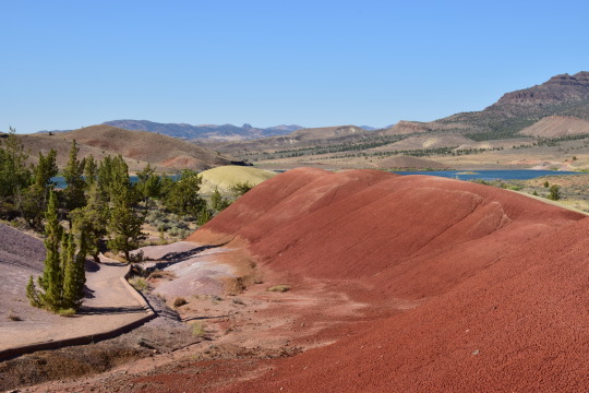
This is a weathered outcrop of rhyolite lava, a lava composition that is mostly quartz by mass. This area grades from purple to brown to red. This is an actual preserved soil horizon. If you dig a hole, you go through different soil horizons - or chemical and physical conditions - before you reach bedrock. Commonly these are O (for organic-rich), A, B, and C. B and C are closest to bedrock and include chunks of weathered, eroded source rock. Here, the purple is that C horizon, then the brown layer is B, and the red is an A horizon mantling the rhyolite lava flow. This whole stack of soil is somewhere around 25 million years old!
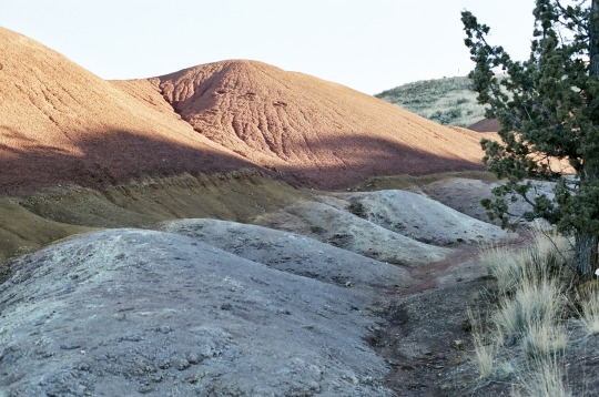
This is one of my favorite rock outcrops in all of Oregon because of how elegantly and simply it displays soil development processes from more than 25 million years ago!
(A note for other geologists: my soil horizon analogy isn't completely accurate since these paleosols have different classifications than regular young soils do, and I'm not very well-versed in those at all)
If you're in to photography, these are (with the exception of the 2nd to last shot) shot on Fuji Color 400 with my Nikon FM2.
#oregon#geology#photography#pacific northwest#bettergeology#adventures#rocks#fujifilm#photographers on tumblr#nikon#film photography#central oregon#eastern oregon#painted hills#john day fossil beds national monument#john day fossil beds
48 notes
·
View notes
Text
National Historic Preservation Month - Trails
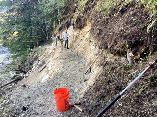
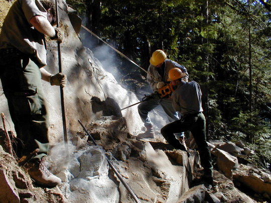
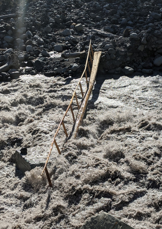
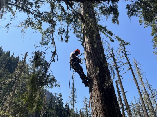
Did you know that Mount Rainier’s Wonderland and Northern Loop Trails are also considered part of the National Historic Landmark District? The first version of the around-the-mountain trail was completed in 1915, at a lower elevation than the current version. Although it has been relocated in places and maintained and rebuilt when required, the Wonderland Trail as a whole has extensive integrity and is one of the most significant and historic trails in the national park system. The trail’s integrity is thanks to a dedicated and hardworking trail crew that works every year to maintain trails throughout the park. On this dynamic mountain, foot bridges frequently wash out, sections slide way, rocks need to be cleared, and more. The park is also 97% designated Wilderness, so often trail crews are doing this repair work without any equipment besides what they can carry in. Have you seen trail crews at work while out hiking or volunteered with a trail crew?
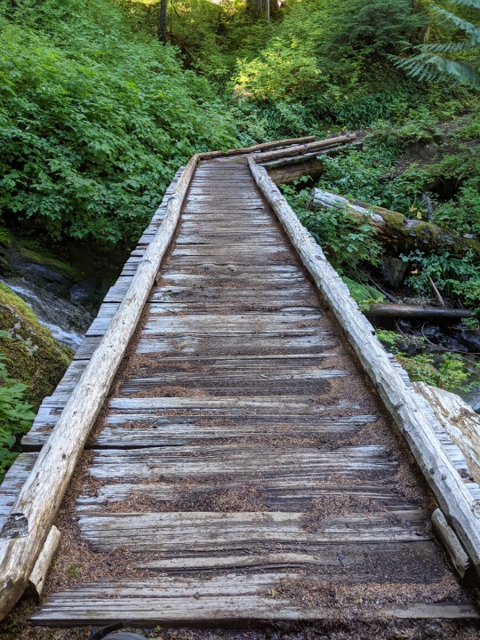
NPS Photos: Trail crew members rebuild a section of trail that had washed out on the Wonderland near Carbon River. Crews drill rocks along a section of the Northern Loop Trail. A washed-out footbridge over the Carbon River. A crew member climbs a tree to install a high lead rigging system to lift a log to place it across a river crossing. A section of wood boardwalk at Doe Creek along the Wonderland Trail after 10 years.
#Historic Mount Rainier#National Historic Preservation Month#Wonderland Trail#Northern Loop Trail#trail crew#trails#trail maintenance#history
25 notes
·
View notes
Text
Cajas National Park Tour
Around 6am the driver was yelling out Cuenca and I wondered if we were here already or if he was shouting out to get people at this station to get onboard for the ride to Cuenca. I wasn’t expecting to arrive until 7 or 8am and my phone didn’t load a map at all which is usually when it’s a random place I’ve never loaded on it before. The driver came down and told me that this was Cuenca, the final stop so I asked for directions to a taxi and headed off. I jumped in one waiting cab and gave him the names of the two streets that my hotel was on the corner of and he found it no problem. The ride on the meter came out to be $1.49 so I gave him $2 and then checked in. I’d booked for the night before so my room was ready waiting and Andrés the receptionist led me upstairs. He was kind and only charged me for one night since I hadn’t been there last night due to the flood that was no fault of my own, and I had contacted him in advance. I would’ve paid the 2 nights if he’d asked but I kept my mouth shut and paid him in cash as he requested. I messaged Edison my tour guide and let him know that I had arrived in Cuenca and was ready for the tour as soon as he was ready. He replied back quickly and said he would pick me up at 8:45am so I took a shower and then went for a quick coffee at Cafe Ñucallacta. Edison picked me up on time and we drove out to Cajas National Park through various different neighbourhoods to get a feel for Cuenca city on our way out. He told me the history of Cuenca, founded in 1557 and it’s the 3rd largest city in Ecuador after Quito and Guayaquil. The historic city centre is a unesco protected world heritage site. This city trades in agricultural products, cattle, hides, and marble. He gave me a few tips on places to visit with my afternoon, evening, and morning before I fly out tomorrow afternoon. It took about 45 minutes to reach the trailhead of the trek in the park we would be doing today. It was about 3400m above sea level and I felt the air was thinner and I was a bit light-headed up here. We began our walk on some rocks and boardwalk, and then for most of the rest of the trek it was a spongy kind of moss that was comfortable to walk on. We walked slowly due to the altitude, and stopped often to look at some trees, birds, plants, and flowers that were unique to the area. Edison kept saying how lucky I was to have this beautiful sunny day to explore Cajas as it’s mostly foggy and cloudy and had snowed there yesterday. I figured by this point I was due some luck! He helped me cross a stream that was terrifying for me with the slippery rocks combined with my bad ankle but I made it and then we stopped for a lunch break at the best viewpoint on the trail. I enjoyed my banana chocolate chip muffin that I’d carried with me from Baños. The loop back to the start was on an incline so it was a bit tougher, and there were some shady spots that were muddy and slippery. We passed a lot of tussock grass, the King Kong rock formation, some spiky pineapple plants, and a tree with layers of papery bark. There were some people beginning their walk in the opposite direction sloshing past us in the muddy spots so I was glad to be wrapping up after having almost the entire walk to myself. He offered to drive me up to the highest elevation point in the park, a lookout at Tres Cruces at an elevation of 4167m above sea level. It was a nice view but very windy up there, and a bunch of children screaming too. Edison drove us back to Cuenca at breakneck speed and dropped me off back at the hotel asking me only for a 5 star review to help the company get more tour business after the difficulties of covid and the negative press on Ecuador and its drug cartels and public safety recently.
3 notes
·
View notes
Text


Alex and I went adventuring out to the state park about 20min from my house. They have this little boardwalk over the lake, and there's a whole ass beach with volleyball and grills and picnic tables too.
This trail also leads over a huge dam which sounds like a beautiful waterfall. It's so peaceful. The loop is about a mile, too, so I did two this morning and then two miles on my treadmill when I got back. It's lovely out there I will be back 💕
4 notes
·
View notes
Text
Top 10 Motorcycle Routes in Singapore to Explore in Motorcycle: Rent and Ride
Singapore, though small in size, holds a plethora of scenic and thrilling motorcycle routes waiting to be explored. Whether you're a seasoned rider or a novice adventurer, the Lion City has something for everyone. With the convenience of motorcycle rental services, exploring these routes has never been easier. So, gear up, hop on, and let's delve into the top 10 motorcycle routes in Singapore that promise breathtaking views, cultural immersion, and unforgettable experiences.

Marina Coastal Expressway (MCE) to East Coast Parkway (ECP) Loop Kickstart your journey with a scenic ride along the Marina Bay skyline via the MCE. Cruise down the ECP, soaking in panoramic views of the coastline and lush greenery. Stop by East Coast Park for a refreshing seaside break before looping back to complete the journey.
Mandai Road to Bukit Timah Nature Reserve Escape the urban hustle and bustle as you navigate through Mandai Road's winding paths surrounded by verdant foliage. Make a pit stop at the Bukit Timah Nature Reserve, where winding roads lead to breathtaking viewpoints amidst Singapore's only remaining primary rainforest.
Punggol Promenade to Coney Island Experience the serenity of Singapore's northeastern coastline with a ride from Punggol Promenade to Coney Island. Traverse along picturesque waterfronts, mangrove swamps, and wooden boardwalks, offering a glimpse into the island's rich biodiversity.
Southern Ridges Trail Embark on a journey through lush greenery and elevated walkways along the Southern Ridges Trail. Start from Mount Faber Park, traverse through Henderson Waves, and culminate your ride at Labrador Nature Reserve, offering panoramic views of the city skyline and the harbor.
Changi Village to Changi Beach Park Explore Singapore's eastern charm with a leisurely ride from Changi Village to Changi Beach Park. Marvel at rustic kampong houses, historical landmarks, and pristine beaches, offering a glimpse into Singapore's rich heritage and natural beauty.
Kranji Countryside Discover Singapore's rural side with a scenic ride through the Kranji Countryside. Meander through quaint farms, orchards, and nature reserves, immersing yourself in the tranquility of lush countryside landscapes juxtaposed against urban skyscrapers.
Sentosa Island Circuit Embark on an exhilarating ride around Sentosa Island's scenic circuit, offering breathtaking views of pristine beaches, iconic attractions, and lush greenery. Explore hidden coves, seaside promenades, and adrenaline-pumping activities along the way.
Western Adventure: Lim Chu Kang Road to Kranji Traverse through Singapore's western frontier with a ride from Lim Chu Kang Road to Kranji. Wind your way through rustic villages, marshlands, and historical landmarks, offering a glimpse into Singapore's agrarian past and natural heritage.
Coast-to-Coast Trail Embark on an epic cross-island adventure along Singapore's Coast-to-Coast Trail, spanning 36 kilometers from Jurong Lake Gardens to Coney Island Park. Experience diverse landscapes, from urban parks and nature reserves to park connectors and scenic waterfronts.
Murai Reservoir to Chestnut Nature Park Conclude your journey with a scenic ride from Murai Reservoir to Chestnut Nature Park, traversing through tranquil reservoirs, lush forests, and idyllic picnic spots. Immerse yourself in the sights and sounds of nature, rejuvenating your spirit amidst Singapore's urban landscape.
Conclusion: From coastal highways to verdant nature trails, Singapore offers a myriad of motorcycle routes waiting to be explored. With the convenience of Singapore's Best Motorcycle rental service, riders can embark on thrilling adventures, immersing themselves in the Lion City's rich tapestry of culture, heritage, and natural beauty. So, rev up your engines, embrace the open road, and embark on an unforgettable journey through Singapore's top 10 motorcycle routes.
#motorcycle rental near me#Singapore's Best Motorcycle rental service#motorcycle rental near Pioneer Point Singapore#Motorcycles for Rent in Singapore#best motorcycle rental in singapore#Singapore motorcycle rental#motorcycle rental near Singapore#Motorbike Rental Singapore#best motorcycle rental near me singapore#motorcycle singapore#motorcycle rental singapore#bike rental sg
2 notes
·
View notes
Text
D.C’s Best Picnic Spots!

Where to go, what to bring
Dining al fresco in D.C. doesn’t have to break the bank. In fact, if you want to avoid making reservations, waiting in line and eating elbow-to-elbow with strangers, planning a picnic is a great alternative. There are so many scenic (Instagram-worthy) spots to throw down a blanket and enjoy this simple and charming tradition. Here we’re sharing some of the best places in D.C. for a picnic – as well as some tips to make your picnic pleasant for all involved.
Hauling your provisions
Although traditional picnic baskets are cute, your best bet is to purchase a modern, sensible picnic backpack since activities in D.C. typically involve walking some distance from your car or taking the metro and hauling a heavy hand-held basket will be cumbersome. Check Amazon for some great options. You can find backpacks with comfortable padded straps and efficiently organized compartments for cutlery, plates, napkins, a cooler, a blanket and more. You might want to invest in two backpacks and share the load with a friend.
Picnic food ideas
Reimagine the ordinary sandwich, chips, and soda. Take it up a notch and serve baguettes; or take it up two notches with quiche, charcuterie boards, fancy salads, and refreshing cocktails. Make sure most of your meal consists of finger foods (easy to eat) so you don’t have to worry about multiple plates/cutlery. And don’t forget dessert!
Another culinary option: order food-to-go from your favorite D.C. restaurant. You’ll still need a method to transport it to your picnic destination, but letting someone else prepare and pack the meal will involve less work on your end.
Don’t forget to pack
Sunscreen
Anti-bacterial wipes
Wet naps
Garbage bags
Bug spray
Places to picnic
We’re providing some tried-and-true venues here, but there are so many more possibilities. Wherever your destination, make sure you learn about parking options (or Metro stops) in advance. Also, do a little research to make sure your spot is picnic friendly and open for visitors.

Between Constitution and Independence Ave., SW
Known as “America’s Front Yard,” this iconic spot is punctuated by the Lincoln Memorial and the Washington Monument and flanked by Smithsonian museums. The long, grassy swath is often crowded, but people-watching can be just as fun as gazing at the patriotic landmarks.
1100 Ohio Drive SW
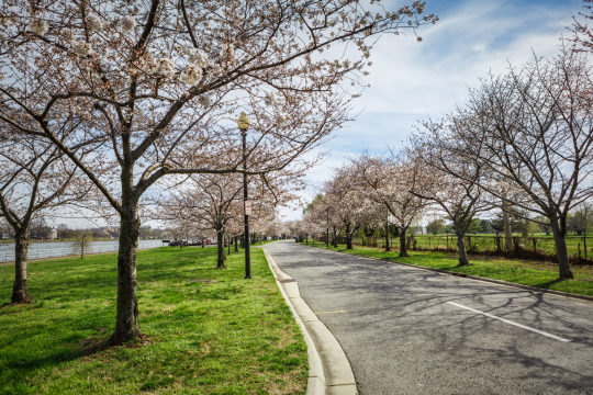
Located at the southern tip of East Potomac Park between the main branch of the Potomac River and the Washington Channel, Hains Point offers beautiful views of the Potomac River, the Anacostia River and the Washington Channel. It’s an ideal spot for bird watching and also has a playground and restrooms. A four-mile loop allows you to take in the many different species of cherry trees while hiking or biking.

Located on the Potomac River and accessible by George Washington Memorial Parkway
This 90-acre island is a memorial to America’s 26th president and features miles of trails through wooded uplands and swampy bottomlands. Ranger-led programs are available.

16th Street and W Street NW
A spectacular cascading fountain, reflecting pool, statues, and more will be your backdrop at Meridian Hill Park (also known as Malcolm X Park). If you’re there on a Sunday afternoon, you’ll most likely be able to watch a full-blown weekly drum circle party starting at 3 p.m., a tradition that began in the 1960s.
The Yards Park (and Dancing Fountains)
355 Water Street SE
This public space along the Anacostia River has gardens, water features, a dog run, a boardwalk and a shaded overlook.
Wisconsin and K St., NW
This 10-acre park curves along the Potomac River shoreline and includes a large fountain, benches, overlooks and large open lawn areas. A labyrinth with geometric turns encourages quiet contemplation as you wind your way from the outer edge to the center. Stadium-like steps leading to the river edge are a favorite place for picnickers.
Hirshhorn Museum and Sculpture Garden
Independence Ave. SW and 7th St. SW
The sculpture garden is free to enter, offering more than 30 works of contemporary and modern art displayed year-round — and picnics are permitted.
#jamierichards#realtorjamier#realestate#realestateagent#realestatetips#picnic#picnics#picnic spots#dmv#dmv picnic spots#picnic in dmv#how to picnic#where to picnic
2 notes
·
View notes
Text
Yosemite Valley Loop Trail Pt 6: Merced River at Swinging Bridge, Sentinel Rock/Falls

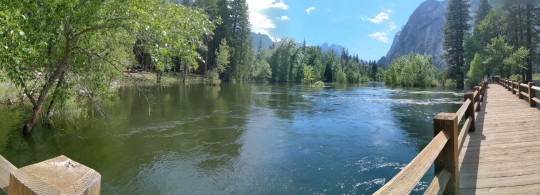
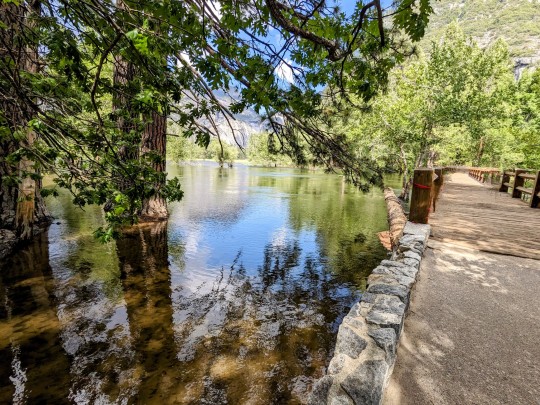


Looking South towards Sentinel Rock and Falls as we cross river at Swinging Bridge.
Trying to give an idea how wide the Merced River is right now. It's like 3x normal width in this area. Swinging Bridge looks like a boardwalk resting on top of the water it's so high at this point.
Video shows panorama from Sentinel Falls around to Yosemite Fall behind us and the river below us.
#yosemite national park#yosemite#yosemite falls#sentinel#sentinel rock#waterfall#merced river#swinging bridge#hiking#video#panorama#scenic#nature#national park
5 notes
·
View notes
Text
My favorite hiking trail is the Nauset Marsh Trail. It is a 1.3 mile loop along the edge of a salt pond with a boardwalk and a gentle forest path.
when i say i like hiking, i don’t mean “eight mile backpacking trip with special gear and an emergency beacon” sort of hiking, i mean a three mile loop to go look at pretty things and then a huge brunch after.
100K notes
·
View notes
Text
Trail Boardwalk
Tho’ a thousand sets of eyes have looked O’er hundreds of years this way trekked The mysterious loop ’round Cooper Island Among the skunk cabbage, foamflower, and turtlehead None yet have found ancient lost treasure Ne’ertheless, wide-eyed wanderers endeavor Scampering across raised boardwalk planks Ducking und’r bellies of mighty trunks Hoping to stumble ‘cross never before seen…
#flora#landscape#mighty trunks#nature#New England#photography#pirate jewels#planks#secret chest#treasure#vision#writing
0 notes
Text
Happy Trails: Family-Friendly Hiking Destinations That Everyone Will Love
Exploring the great outdoors through hiking is an excellent way for families to bond, instill a love of nature in children, and encourage a healthy lifestyle. However, not all trails are suitable for little legs or strollers. Finding the perfect family-friendly hiking destination requires consideration of trail difficulty, safety features, and exciting elements that can keep children engaged throughout the adventure. This guide highlights some of the best family-friendly hiking destinations across the country, ensuring a memorable and enjoyable outdoor experience for hikers of all ages.
1. Great Smoky Mountains National Park, Tennessee/North Carolina
The Great Smoky Mountains National Park offers a range of family-friendly trails that showcase the diverse flora and fauna of this stunning region. One of the most popular hikes is the Laurel Falls Trail, an easy 2.6-mile round trip that leads to a beautiful waterfall. The path is well-paved, making it accessible for strollers and walkers of all skill levels, and the waterfall itself provides a perfect backdrop for family photos.
2. Acadia National Park, Maine
Acadia National Park features trails that offer breathtaking views of the Atlantic Ocean alongside dense forest landscapes. The Ocean Path Trail, in particular, is a gentle 4-mile round trip that takes families along the rocky coast with plenty of spots to stop, explore tide pools, and observe wildlife. The trail is primarily flat and well-maintained, ideal for families with young children or those looking for a leisurely walk with spectacular views.
3. Yosemite National Park, California
Yosemite is known for its majestic landscapes and family-friendly hiking options. The Lower Yosemite Falls trail is a short 1-mile loop that offers stunning views of the highest waterfall in North America. The trail is mostly flat and paved, and the awe-inspiring sight of the waterfall is a beautiful reward for hikers of all ages. The park also offers various educational programs geared towards young visitors, making it a great learning experience in addition to being physically active.
4. Rocky Mountain National Park, Colorado
Rocky Mountain National Park provides a variety of trails that cater to families looking to explore the rugged beauty of Colorado. The Bear Lake Trail is an easy 0.8-mile loop that circles a picturesque lake set against the backdrop of towering mountains. The trail is well-traveled and primarily flat, perfect for families with toddlers or those pushing strollers. Moreover, the park's frequent wildlife sightings of elk and deer thrill children and adults alike.
5. Shenandoah National Park, Virginia
Shenandoah National Park, with its rolling hills and spectacular views, is a haven for families seeking a peaceful hike. The Stony Man Trail is a relatively easy 1.6-mile round trip that leads to one of the park's highest points. The trail is not too steep and offers incredible views of the Shenandoah Valley, making it a rewarding hike for families. The trailhead is also close to Skyline Drive, making it easily accessible for families traveling by car.
6. Zion National Park, Utah
Zion National Park's Emerald Pools Trail is an excellent choice for families. This hike ranges from easy to moderate and features multiple stops at beautiful waterfall-fed pools. The Lower Pool is just a short 1.2-mile round trip and has minimal elevation gain, making it manageable for families with young children. The trail offers shaded areas, scenic views, and the chance to spot local wildlife.
7. Glacier National Park, Montana
The Trail of the Cedars in Glacier National Park is an accessible, flat loop that runs for about a mile through ancient cedar forests alongside a flowing stream. This trail is wheelchair and stroller-friendly, featuring boardwalks and raised platforms that make it easy for everyone in the family to enjoy the natural beauty. It's particularly magical for kids, who love the fairy-tale feel of the lush forest.
8. Olympic National Park, Washington
Olympic National Park's Hoh Rain Forest offers the Hall of Mosses Trail, a short 0.8-mile loop that immerses families in a dense, green world of old-growth forest and moss-draped trees. This trail is like stepping into another world, with its easy terrain and enchanting landscape that captivates children’s imaginations and adults’ sense of wonder.
Choosing the right trail can make hiking an enriching experience for families, fostering a lifelong appreciation for nature and physical activity. These family-friendly hiking destinations provide safe, accessible, and beautiful environments for creating lasting memories. Whether it’s witnessing the majesty of waterfalls, exploring tide pools, or wandering through ancient forests, these trails ensure that everyone, from toddlers to grandparents, will have a delightful experience. So pack your bags, grab your hiking boots, and set off on a family adventure that will be talked about for years to come.
0 notes
Text
Tuesday, October 15 - Robinson Crusoe Island, Chile


What a perfect day. Today was our final stop on this incredible journey, and it was a fitting end. Robinson Crusoe Island is where Alexander Selkirk was marooned for over four years, and although it was uninhabited then, there is now a population of less than 1000. With inhabitants, there also came a variety of non-native plants and animals, much to the detriment of the native, endemic species. Being early Spring here, the gardens were in full bloom, though, and everything was colorful and lush.
We had a whole day here, and our morning choices were two different hikes (an extremely strenuous hike or a moderately strenuous hike), a town stroll, or exploration on one's own. We chose the moderately strenuous hike since it was going up into the forest, but also had terrific views, and more importantly, Joe, our ornithologist. There were ten of us with a local guide and we quickly broke into two groups - the fast hikers and the birders. Robinson Crusoe Island is home to two birds found no where else, and we were determined to find them. One is the endangered Juan Fernandez Firecrown - a fairly large orange-red hummingbird sometimes seen in gardens, but more often out in the forest. The other is the Juan Fernandez Tit-tyrant, a small flycatcher. It's nice to have a goal.
We started climbing through the town, as there is very little flat terrain on this volcanic hunk of rock. The highest point is just over 3,000 feet, which is considerable on an island of just 18 square miles. Eventually the concrete road became a dirt track and we entered the National Forest (most of the island is in the National Forest except for the town of San Juan Bautista and a few other places along the shore). We located several Tit-tyrants in some bushes, and continued on. Our trail finally led to a flat plazoleto with picnic tables, flush toilets and a grill and outdoor sink, at about 1000 ' elevation. From here there was a lovely circular boardwalk route that took us through dense native (and non-native) vegetation. Although we had had glimpses of the Firecrown earlier in the distance, here one chose to land on a branch right in front of me, and I got some good shots before he decided to fly off. We also saw the female as well as the Green-baked Firecrown, which has somehow made its way here from South America.
The boardwalk was well-constructed, and every step was edged in yellow, which was helpful in the dim light of the forest. The ground was covered in forget-me-nots, adding a blue carpet everywhere. We were lucky that the weather was perfect for hiking - in the upper 50's with mostly overcast, and very little wind. The temperatures here are tempered by the Humboldt Current, which runs between here and the mainland, over 400 miles to the east. It appears to be cold enough for some fruit trees, as they were in bloom, but also warm enough that the geraniums (pelargoniums) grow into bushes.
After our loop, we headed down the trail a ways, and chatted with our local guide (he is currently a teacher here, but did his Masters on the Juan Fernandez Fur Seal, and has worked with Nat Geo both here and in Antarctica, where he also did research on penguins). Unlike Easter Island, this island does seem to more resemble coastal Chile, as it was never settled by Polynesians, and the Chilean flag flies everywhere. Closer to town, we split off on our own to explore a bit in the various neighborhoods. Seabourn had scheduled a "pirate party" at a local establishment in the early afternoon, so we had time to try to find a trail we had on our map that would lead to another bay. We never really found it, but did manage to get more steps in climbing a few hills searching for it.
The party was a blast, especially since it was our last day on land together. Locals were dressed as pirates and we had lovely crab and chicken empanadas, as well as generous tastes of local lobster and octopus, and potent pisco sours. The live band played mostly local music and was excellent, and it was a great way to end the cruise. We even have a detour on our Zodiac ride back to the ship to visit some fur seals playing in the water in a cave down the coast line.
Once everyone and all the Zodiacs and subs were back on board we took our time sailing away, and the island was still visible to the west as the sun went down and we sat on the patio for dinner. Afterwards, Lupi and the two guest entertainers, Chris and Dave, put on a show, singing solos, duets and finally a three-person medley from Les Miz. What a great day.
One note on the pics - the round tank with the little gun reminded me of a Dalek, so I had to take its picture. Tomorrow we finish packing and get ready for disembarkation the following morning. There's a lot going on with activities, but we'll see how much we want to participate. It should be good whale and bird watching on deck, too.
0 notes
Text
Saturday September 7, 2024
Awesome day #5. The Camino Portuguese has 4 different routes: the Central Route, the Variante Espiritual which includes a boat ride through the world’s only maritime stations of the cross, the Coastal, and the Senda Litoral which follows the actual coastline. We’ve been following the coastline, but today opted to take the Coastal. Today we climbed a bit more, went through some really cool towns and saw over a hundred other pilgrims!
We walked through what seemed like a continuous village for the first 4 miles. We enjoyed peering into the gardens and looking at their landscaping and architecture. We stopped at a church that had a water fountain and clean bathrooms. Fewer cafes on this route, but great trail markings and adequate water and toilet stops!
We stopped at a cafe that had a few pilgrims and also many locals. We bought coffees and hot chocolate and had snacks from our packs. The locals were drinking beer and wine (it was 10:30am). The locals would greet us with cries of “Bom Caminho!”
After about 4 miles, we entered a magical forest with pines and eucalyptus trees! The smell was amazing! It was the first time we employed our hiking sticks and we were glad we had them! It felt great to be hiking on a path over rocks and roots as opposed to boardwalks and cobblestones?
We came to a river with a small stone dam / bridge where the trail crossed. We took the opportunity to take a break and some of us soaked our feet. Blister on my little toe where I used to have a callus before I started getting pedicures regularly! It’s not bothering me however.
We continued through small neighborhoods and alternated woodland paths where we basked in the scent of pine and eucalyptus and enjoyed the shade.
As we approached the village of Chafe, we could hear loud, festive music, which was unusual. We wandered through the village and came to an actual festival! There were food trucks and drink stands set up, and Jeff and I decided we needed a cheeseburger and the others needed a beer! As we were waiting, a parade gathered and went by - mainly drums, and a few accordions. It was fantastic. There were 5 different groups, and they made a loop around the little church square. Some ladies in costume were starting to gather, but we didn’t hang around to see what happened next.
We continued on and started to pass a lot of end of day stragglers who appear to be in pain. As a group, we’re all doing well so far - good conditioning.
We booked a family room in the hotel - Matt and Sandra have the queen bed; Jeff, Janet and I each have a single bed in a separate small room - one bath to share. Needless to say, we’re all getting more comfortable with one another!
Out for a beer until the pizza restaurant opened at 7pm. Salad and pizza, with some leftover for tomorrow’s snack! We finished the dinner with a couple glasses of Grapa. Jeff tipped the server well and he brought two more glasses of Portuguese Grapa, which was awesome! We’ll look for some of it to take home.
0 notes
Text
Exploring Austin's Best Morning Walks: A Guide to Scenic Trails and Urban Paths

Austin, Texas, is a city that boasts an eclectic blend of urban sophistication and natural beauty. Its vibrant culture, thriving music scene, and an array of outdoor activities make it a perfect destination for those who love to explore on foot. Morning walks in Austin offer a unique opportunity to witness the city's charm while soaking in the tranquility of its scenic trails and urban paths. Whether you're a local or a visitor, here’s a guide to some of the best morning walks in Austin.
1. Lady Bird Lake Hike-and-Bike Trail
One of Austin's crown jewels, the Lady Bird Lake Hike-and-Bike Trail, offers a picturesque escape right in the heart of the city. This 10-mile loop around Lady Bird Lake provides stunning views of the water, the downtown skyline, and lush greenery. The trail is well-maintained and accessible, making it a favorite for walkers, joggers, and cyclists alike.
Start your morning walk at Zilker Park, where you can catch the first rays of sunlight over the lake. As you stroll along the trail, you'll pass by landmarks such as the Pfluger Pedestrian Bridge and the Stevie Ray Vaughan statue. Early mornings here are serene, with birds chirping and the occasional paddleboarder gliding across the water. Don’t forget to stop by the Boardwalk section for some of the best panoramic views of the city.
2. Barton Creek Greenbelt
For those looking to immerse themselves in nature, the Barton Creek Greenbelt is a must-visit. This 7.25-mile stretch of trails offers a variety of terrains, from rocky paths to smooth trails, all surrounded by lush forests and the soothing sounds of Barton Creek. The Greenbelt is a haven for outdoor enthusiasts, with opportunities for hiking, rock climbing, and even swimming in natural swimming holes.
Begin your walk at the Barton Springs Pool entrance, where you can enjoy the cool morning air and the sound of water flowing through the creek. As you venture deeper into the Greenbelt, you’ll encounter spots like the Twin Falls and Sculpture Falls, perfect places to take a break and enjoy the natural beauty. The early hours are ideal for avoiding the heat and crowds, making it a peaceful retreat.
3. Mount Bonnell
For a walk that combines a bit of a workout with breathtaking views, Mount Bonnell is the perfect choice. Rising to about 775 feet, Mount Bonnell offers one of the highest points in Austin and provides an expansive view of the city and the Colorado River.
The walk up to Mount Bonnell involves a series of steps, but the effort is well worth it. Once at the top, you’ll be greeted with a panoramic view that’s especially stunning at sunrise. Bring your camera to capture the golden hues reflecting off the river and the city awakening below. There are also picnic areas at the summit, making it a great spot to enjoy a quiet breakfast with a view.
4. Mueller Lake Park
Located in the trendy Mueller neighborhood, Mueller Lake Park is a delightful urban oasis perfect for a morning stroll. The park features a 30-acre lake, walking trails, playgrounds, and an array of public art installations. It’s a family-friendly destination that also attracts bird watchers, joggers, and those looking to relax by the water.
A walk around Mueller Lake is about 1.2 miles, making it a leisurely yet fulfilling route. Start your walk at the lake, where you can observe ducks and other waterfowl beginning their day. The trail is dotted with benches and shaded areas, providing plenty of spots to sit and enjoy the surroundings. The park also hosts a weekly farmers' market on Sundays, so if your walk extends into the late morning, you can indulge in some local treats.
5. South Congress Avenue
For a more urban walking experience, South Congress Avenue (SoCo) offers a vibrant and eclectic route. This iconic street is lined with boutique shops, art galleries, cafes, and restaurants, making it a cultural hub of Austin.
Start your morning walk at the Congress Avenue Bridge, where you might catch a glimpse of the famous Austin bats returning from their nighttime foraging. As you head south, you’ll pass by landmarks like the historic South Congress Hotel and the quirky "I love you so much" mural. The street comes to life early, with cafes opening their doors to serve breakfast and coffee. It's the perfect place to end your walk with a delicious meal or a cup of locally brewed coffee.
Conclusion
Austin’s blend of urban landscapes and natural beauty offers an array of options for morning walks, each providing a unique perspective of the city. Whether you prefer the tranquility of a lakeside trail, the challenge of a hill climb, or the vibrancy of an urban stroll, there’s a perfect route waiting for you. So lace up your walking shoes, grab a water bottle, and set out to explore the best of Austin on foot. Your morning walk awaits!
0 notes
Text
Pedal through Brooklyn to Have Fun Rides for Children and Adults on Bikes
Brooklyn, with its vibrant neighborhoods and scenic views, offers a fantastic setting for bike rides suitable for both children and adults. Whether you're looking to spend a fun day with your family or seeking a peaceful solo ride, Brooklyn has numerous bike-friendly routes and trails to explore. Here’s a guide to some of the best bike rides in Brooklyn for all ages.

Prospect Park:
Prospect Park is a haven for cyclists. This 585-acre park boasts a dedicated bike lane that circles the entire park, making it a safe and enjoyable option for riders of all ages. The loop is about 3.35 miles long, perfect for a leisurely bike rides for children and adults in Brooklyn. You can enjoy scenic views of the lake, the zoo, and plenty of green space where you can stop for a picnic.
Brooklyn Bridge Park:
Located along the East River, Brooklyn Bridge Park offers stunning views of the Manhattan skyline. The park has well-maintained bike paths that are ideal for both novice and experienced cyclists. Children will love the various playgrounds and picnic areas, while adults can appreciate the beautiful waterfront and recreational piers. The park’s paths connect seamlessly to the Brooklyn Greenway, offering extended riding opportunities.
Ocean Parkway Bike Path:
The Ocean Parkway Bike Path is one of the oldest bike paths in the United States. Stretching from Prospect Park to Coney Island, this path is flat and straight, making it a great choice for families with children. The route is approximately 5 miles long and provides a direct and enjoyable ride to the beach. Once you reach Coney Island, you can take a break to enjoy the boardwalk, amusement parks, and the beach.
Shore Parkway Greenway:
For a longer and more adventurous ride, the Shore Parkway Greenway offers a picturesque route along Brooklyn’s southern coast. This bike path runs about 4.5 miles from Bensonhurst Park to the Verrazzano-Narrows Bridge. The path is wide and smooth, suitable for riders of all skill levels. It’s an excellent choice for families wanting to spend a day biking by the water and enjoying the sea breeze.
Red Hook:
To enjoy bike rides for children and adults in Brooklyn, Red Hook is a trendy neighborhood with a unique industrial charm. The area features several bike lanes and quiet streets, making it a pleasant place for a family ride. Visit the Red Hook waterfront to see the Statue of Liberty and enjoy the local parks and eateries. The area is relatively flat, making it accessible for younger riders.
Tips for Safe and Enjoyable Bike Rides:
Wear Helmets: Always ensure that both children and adults wear helmets for safety.
Follow Traffic Rules: Obey all traffic signals and signs, and stay in designated bike lanes whenever possible.
Pack Essentials: Bring water, snacks, and a basic first aid kit.
Plan your route: Choose routes that match the skill level of all riders, especially when biking with children.
Stay Together: Keep an eye on younger riders and stay together as a group.
Exploring bike rides for children and adults in Brooklyn is a delightful way to experience the borough’s beauty and charm. With diverse routes catering to different skill levels and interests, there’s something for everyone. So, grab your bike and helmet, and embark on an exciting biking adventure in Brooklyn!
0 notes
Text
Exploring Delaware: A Guide to Outdoor Activities
Delaware, often celebrated for its rich history and small-town charm, also boasts a remarkable array of outdoor activities that cater to adventure seekers, nature lovers, and families alike. Delaware provides countless outdoor exploration and enjoyment opportunities, from its picturesque coastline to lush state parks. This article highlights some of the top outdoor activities in the First State.

Beach Adventures on the Delaware Coast
Delaware's coastline is a haven for beach enthusiasts. The state's famous beach towns, such as Rehoboth Beach, Bethany Beach, and Dewey Beach, offer clear waters, sandy shores, and a variety of Delaware recreational activities. Visitors can enjoy swimming, sunbathing, and beachcombing along the Atlantic Ocean.
Rehoboth Beach, known for its vibrant boardwalk, is perfect for family outings. The boardwalk has shops, eateries, and amusements, creating a lively atmosphere. Surfing, paddleboarding, and jet skiing are popular water sports here. Cape Henlopen State Park, located near Lewes, also provides scenic beaches, hiking and biking trails, and historic sites, making it a good destination for a full day of outdoor fun.
Hiking and Biking in Delaware's State Parks
Delaware's state parks offer some of the region's best hiking and biking trails. White Clay Creek State Park, located near Newark, features over 37 miles of trails that wind through forests, meadows, and along the creek. The park's diverse terrain caters to novice and experienced hikers and bikers. Its serene landscapes and wildlife make it a favorite among nature enthusiasts.
Lums Pond State Park, the largest freshwater pond in Delaware, provides numerous trails, including the famous Swamp Forest Trail, which offers a scenic loop around the pond. The park also has a Go Ape Treetop Adventure course, where visitors can enjoy zip-lining and treetop obstacles.
For a unique hiking experience, the Brandywine Creek State Park, near Wilmington, features trails that meander through rolling meadows and along the Brandywine River. The park is perfect for birdwatching, with various species of birds making their home in the area.
Kayaking and Canoeing on Delaware's Waterways
Delaware's rivers, creeks, and ponds provide excellent opportunities for kayaking and canoeing. The scenic Nanticoke River flows through southwestern Delaware, offering a peaceful setting for paddling adventures. The river's calm waters are ideal for beginners, and the surrounding landscape is rich in wildlife, including bald eagles and herons.
Camping and Fishing for Nature Enthusiasts
Delaware offers several state parks with well-maintained campgrounds for those who love camping. Killens Pond State Park, located in Felton, features a campground with modern amenities and access to the park's 66-acre pond. Visitors can enjoy fishing, boating, and hiking in the park.
Freshwater fishing is also plentiful in the state's numerous ponds and lakes. Records Pond in Laurel and Silver Lake in Dover are well-known fishing spots where anglers can catch bass, crappie, and catfish.
Wildlife Watching and Birding
Delaware's diverse habitats provide excellent opportunities for wildlife watching and birding. Bombay Hook National Wildlife Refuge, located near Smyrna, is a premier birding destination. The refuge's tidal salt marshes, freshwater pools, and upland habitats attract a wide variety of bird species, including migratory shorebirds, waterfowl, and raptors. The refuge features driving and walking trails, observation towers, and blinds for optimal birdwatching.
Prime Hook National Wildlife Refuge, near Milton, is another top spot for birding. Its extensive trails and waterways allow visitors to explore different habitats and observe wildlife. The refuge is mainly known for its fall migration when thousands of birds pass through it.
The rich natural resources and diverse landscapes make it a prime destination for Delaware outdoor activities. Whether you're looking to relax on the beach, hike through scenic trails, paddle along serene waterways, or enjoy golf, Delaware has something to offer everyone. The state's commitment to preserving its natural beauty ensures that these outdoor adventures can be enjoyed for generations. So, pack your gear and explore the many outdoor activities Delaware offers!
#Exploring Delaware#explore Delaware#Delaware#Delaware outdoor activities#Delaware recreational#outdoor activities in Delaware#outdoor activities
0 notes
Text


Lake Williams Boardwalk June 2, 2024 Marlborough, Massachusetts
The "boardwalk" is actually a 3,000-foot floating walkway that stretches all the way across the lake, and if you're feeling ambitious, there is a nature trail that loops back around to the parking lot.
#massachusetts#marlborough#lake williams#boardwalk#floating walkway#nature trail#summer day#beautiful day#day at the lake#googly eyes#our adventures
0 notes